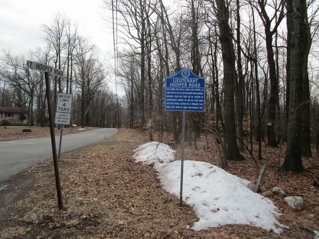
Was named for 2nd Lt. Josiah (Joe) Hooper. As chief pilot of a B-24, he flew many WWII bombing missions from Italy over the oil centers of Southeastern Europe. He and his crew were lost over Vienna, Austria on 21 February 1945 when shot down by . . . — — Map (db m92645) HM
Refuge of local signer of The Declaration of Independence while hiding from the British. His estate ransacked by Hessians, he was financially ruined and died in 1779. — — Map (db m229683) HM
Built west from Elizabeth and Jersey City in the 1830s, reaching Easton in 1852. This stop spawned the town of Clinton Station, renamed Annandale in 1873. — — Map (db m16926) HM
Established in 1760 by Captain Thomas Jones. During the Revolution was one of the recruiting stations for the militia of Hunterdon County. — — Map (db m18184) HM
Settled by Baptists in the 1720s. One of the area's older towns astride the Old Kings Highway (now Rte. 519), it offered a tavern, stores, and various artisans. — — Map (db m16662) HM
Continental troops camped here in December 1778 while escorting British and Hessian prisoners to Virginia.
The enemy troops were captured in the Battle of Saratoga. — — Map (db m16664) HM
Once Charlestown and Larisonville; renamed by 1859 after early resident. An 1823 tavern, blacksmith shop & several stores formed the town's business core. — — Map (db m30637) HM
Midpoint of the Musconetcong Mountain Range was named for 1761 "Jug" Tavern at the bottom of the hill to the west. The 4900' Lehigh Valley RR tunnel beneath was the longest in the East in 1875. Second tube opened in 1928. — — Map (db m62292) HM
Frequent dangerous accidents on Jugtown Mountain led to the first installation here of the concrete road dividers, which later became famous and are now also in use to defend against terrorists. — — Map (db m36097) HM
Dating back to the 1840's, this farm was purchased for Thomas Edison's storekeeper, Frederick Devonald, in 1932 and remained in the family until 1983. Unusual springhouse consists of two levels. — — Map (db m68387) HM
Known earlier as California, its name dates to the gold rush days. By the 1870s, its water powered mills and the High Bridge RR brought growth. Post office est. 1878. — — Map (db m21811) HM
Founded by Lance family in 1749, and occupied by descendants until 1926. Home to Jehovah's Witnesses
for 57 years, until 1999. Now in the County Park System. — — Map (db m16705) HM
Railroad operated between Scranton and Hampton from 1856 until 1959 when bridge was razed by Delaware, Lackawanna And Western Railroad. — — Map (db m16612) HM
Connected the Central Railroad to the Delaware, Lackawanna & Western Railroad along the Delaware River. Completed 1862; track torn up c1960. — — Map (db m16671) HM
Known earlier as Dogtown for the 1737 tavern built here. Named for the Cherry family in 1839. The church was organized in 1849, the post office in 1850. — — Map (db m21929) HM
The first regiment of Minute Men in the colonies formed here in 1775. Built in 1767 on the main road
from New Brunswick to Easton. — — Map (db m16707) HM
Built by Johannes Cristofel Vought in 1759, the house features unique aspects of Germanic construction. Vought was the active loyalist leader in his area during the Revolution. — — Map (db m21804) HM
Until 1930 this intersection was the turn-off point for west-bound motorists who opted to drive northward to avoid the Jugtown Mtn. grades toward Phillipsburg and Easton. — — Map (db m45880) HM
Born in High Bridge in 1808 to the iron-making family, he lived in Clinton. Hunterdon's only Civil War general. Killed in 1862 at Manassas, Va. while leading the 1st NJ Brigade. Buried west of the church. — — Map (db m18182) HM
Red Mill ca. 1810. Processed wool, plaster, grist, talc, graphite. Once generated electricity. Limestone quarry mined from early 1800's to 1963. — — Map (db m52939) HM
1837 grist mill ground various products until 1952 when it became a cultural center. Presents visual arts exhibitions and education programs. — — Map (db m16628) HM
This point marks the intersection of the upper and lower Minisink Trails connector used by Lenape for travel and trade between the Delaware and Raritan Rivers. — — Map (db m45882) HM
1890 structure included 300-seat theater and two offices. Hosted variety acts in 1880’s, then live touring shows until 1904. Opened briefly in mid-1960’s and 1970’s. — — Map (db m16625) HM
Boy scout camp 1938-1974. Named for Samuel Buck (1874-1937), first High Bridge Troop 149 Scoutmaster & V.P. of Taylor-Wharton Iron & Steel Co. — — Map (db m55268) HM
A pure example of Greek Revival architecture, erected in 1851. Seven other early churches in nearby counties use this basic design. — — Map (db m16672) HM
By 1816 copper ore was found here, and north towards Flemington. The mining craze lasted through 1865. It was never profitable, but gave Copper Hill its name. — — Map (db m60787) HM
Lenape Tribes used the abundant Hunterdon mineral for arrowheads and tools. One of their trade routes, later the Easton-Trenton Road, ran southwards toward Sanhican (Trenton). — — Map (db m59401) HM
Originally called Everitts Mill, the village once comprised of a mill, post office, schoolhouse, tavern, blacksmiths shop, tailor shop, two storehouses, and approximately 25 dwellings situated on the Nishisakawick Creek. Founded in 1759. — — Map (db m55266) HM
Known as Everitts Mills by 1759, then Everittstown by 1816. A post office served the town from 1848 until 1912, also a blacksmith shop, stores, a tailor, the grist and oil mill, plus the old tavern. — — Map (db m71544) HM
Founded in 1727, the congregation was originally German Reformed. First a log building. A series of
larger structures followed. Present building erected in 1851 and remodeled in 1902. — — Map (db m16933) HM
Major Lambert Boeman of the 15th NJ Infantry is buried here just to the east. He was killed at Cedar Creek, VA in October of 1864 while in command of the 10th NJ. — — Map (db m72696) HM
Found here and south towards the area of Copper Hill as early as 1816. Mining craze lasted 50 years, but limited amounts of ore never allowed commercial success. — — Map (db m33205) HM
The country’s first, and, at one time, the largest,
cooperative egg auction. Operated here from 1932 until the death of the egg business in the 1960s. — — Map (db m16682) HM
Site of the County's second longest continuously operated agricultural fair from 1865 until moved in 2001 to county property below Ringoes. Also the site of the renowned 5/8 mile oval Flemington Speedway 1910-2002. — — Map (db m62382) HM
Johann Kase purchased land from Penn family 1738. Built a log cabin with help of Chief Tuccamigan’s tribe. Stone mansion house built ca. 1798. — — Map (db m16690) HM
The first confirmed burial here was 1794 concurrent with the erection of the church. It originally had a section for "colored and strangers" who were eventually honored with a 1999 monument. Today, it is the resting place of founding church members, . . . — — Map (db m83102) HM
In 1864 provided Flemington’s second rail line.
Passenger station erected here. A turntable to the west reversed the locomotives. — — Map (db m16687) HM
The former estate of Judge George K. Large, who willed it to the public in 1963. The buildings are gone, but the land is now a park and Green Acres area. — — Map (db m21263) HM
Top
Town takes its name from the many French families that followed Paul Henri Mallet-Prevost, a Swiss refugee from the French Revolution who moved here in 1794. Bottom
Called "Sunbeam" in 1759. Later Sherrard's Ferry. Present name for . . . — — Map (db m17079) HM
The Belvidere-Delaware Railroad c.1853.
Later leased to the Penn R. R. System, the line allowed transit of Lehigh & Hudson R. R. passenger trains. — — Map (db m16648) HM
Lenape tribes used this abundant Hunterdon mineral for spearpoints and tools. One of their trade routes followed the River Road (now Rte. 29) southwards toward Sanhican (Trenton). — — Map (db m114648) HM
In 1778 the Continental Congress moved 4,916 British and German troops captured at Saratoga, south from Boston along today's Route 513, crossing the Delaware at Sherrard's Ferry (Frenchtown). Many escaped along the way but 3,600 reached Virginia, to . . . — — Map (db m46194) HM
Named In 1871 For Chair Factory Family Eveland’s Tavern In 1760, It Was Later Known As Sodom, And In 1820, Clarksville, After A Local Merchant. — — Map (db m17409) HM
Hunt family was major benefactor to Glen Gardner. House owned by Dr. A.A. Hunt in late 1700's. House across street built by his son, Dr. T. E. Hunt, in 1853. — — Map (db m17410) HM
It served as a burial ground from 1844 to 1915. Built by "Stuttering Jake" Swackhammer for the ministry of his uncle, Rev. Lambert Swackhammer, an opponent of slavery and alcohol, its church members over the years were predominantly of the Lutheran . . . — — Map (db m83711) HM
Present building was dedicated in 1871. Three structures preceded it on the site; erected in 1730, 1760, and 1830. Many Continental Army soldiers buried here. — — Map (db m16630) HM
The original 1763 home was here. Commissary-General Charles Stewart feted officers of the Continental Army. House replaced c. 1800 by the imposing stone residence across the road. — — Map (db m71560) HM
The meeting place of the NJ Central and DL & W RRs, earlier known as Junction. Extensive RR shops and a huge coal storage yard were sited here. — — Map (db m21189) HM
Known for years before 1909 as junction. Central RR of NJ & DL&W railroads met here. Site of extensive machine shops and a huge coal storage facility set up to get nearer the city areas to the east. — — Map (db m16702) HM
The nearby Union Ironworks built this house in 1760 as the residence of the superintentent . Enlarged in the 1830s, it was purchased by the State of NJ in the 1960s , when the reservoir was being built. It is now open as a historical museum. — — Map (db m92614) HM
Home of Union Forge, maker of early farm equipment,
cannonballs for Continential Army. Factory, later known as Taylor Wharton ceased operations in 1971. — — Map (db m5039) HM
Constructed 1859-1865 for the Central Railroad of New Jersey, this 112 foot earthen embankment double arch culvert supports the original bridge from which the Borough of High Bridge is named. — — Map (db m5040) HM
Patriots imprisoned loyalist Pennsylvania Governor John Penn and Crown Supreme Court Justice Benjamin Chew here during the Revolutionary War. They named the place “Solitude.” — — Map (db m73998) HM
Taylor Iron & Steel Company
Was the center of the original 1742 Union Iron Works. Late 1800's push to rename High Bridge to "Tisco" failed. — — Map (db m36997) HM
Furnace produced iron ore for the Continental Army, cannon balls, farm implements. Forgemaster's house is stucco building on slope. The William B. Honachefsky Memorial Tract encompasses 64 Acres, abutting Union Furnace — — Map (db m92789) HM
Foster M. Voorhees, born in Clinton in 1856, served as the 37th & 39th governor of NJ from 1898 to 1902. After his death in 1927, his farm here became Voorhees Park — — Map (db m71406) HM
A rock formation here on Pero's Hill in East Amwell Township stands among the more unusual in an area of diverse geology. Local legend persists the three brothers hoping to overcome the Devil were turned to stone to stand here today. — — Map (db m95585) HM
Founded 1816,
the first Methodist Church
in Hunterdon County.
Building erected in 1860.
Steeple removed in 1878
after a severe storm — — Map (db m17583) HM
A log tavern on this site ca. 1764 offered shelter to travellers on the King’s Hwy. Later tavern ca. 1790 known for years as Johnson’s. — — Map (db m16829) HM
Revolutionary War Lieutenant, and pallbearer of George Washington is buried here, along with Sam Holcombe, one of Gen. Washington's spies. — — Map (db m16861) HM
Used during the Revolutionary War by both Gen. George Washington and British Gen. Charles Cornwallis to view opposing activity up & down the river. This local promontory has long since been known as Washington's Rock. — — Map (db m62383) HM
Earlier known as Coates' Ferry, then Coryell's Ferry.
The Lambert family settled here circa 1735, and gave the town its current name. — — Map (db m16860) HM
From 1949 Until 1971 Many Famous Film And Stage Stars
Got Their Start In One Of The Country’s First Tent Theaters Located First In Lambertville And Then Here In West Amwell. — — Map (db m17082) HM
The Belvidere-Delaware Railroad c.1851. Later leased to the Penn R.R. System, the line allowed transit of Lehigh & Hudson R.R. passenger trains. — — Map (db m16857) HM
The Bel-Del Railroad shops stood between the station and the river. Along with repairing trains, the shops built locomotives between 1864 and 1872. — — Map (db m16855) HM
Washington's army left Valley Forge in 1777 and moved northeast. They crossed the Delaware at Coryell's Ferry (Lambertville), remained for two days, then marched along today's Rte.518 on their way to the Battle of Monmouth on June 28th. — — Map (db m49216) HM
Originally named “Jacksonville” after Andrew Jackson.
Major stop on Easton-New Brunswick Turnpike from 1806. Town set off from Clinton Township in 1926. — — Map (db m16769) HM
Established in 1929, the facility promoted the farm school ideas of communal living and outdoor health. Like similar institutions of the era and in keeping with the ideals of juvenile reform, the facility originally had no fences to disrupt the . . . — — Map (db m40681) HM
In 1913, the State of New Jersey acquired 747 acres to establish a farm colony to treat the mentally ill. During World War I, inmates from the reformatory at Rahway farmed the property to provide emergency food supplies for the war effort. After the . . . — — Map (db m40766) HM
Grist mill and several houses here in mid 1700's.
Known as Burnt Mills after fire in 1769. Ferry to Pennsylvania here until 1842 when a bridge was built. — — Map (db m16646) HM
The Belvidere-Delaware Railroad c.1853. Later leased to the Penn R.R. System, the line allowed transit of Lehigh & Hudson R.R. passenger trains. — — Map (db m16750) HM
The Oswaego Express plunged through a washed out bridge over Quequacommisscong Creek just to the south on 4 October 1877 after its last stop in Milford. Eight died. — — Map (db m85969) HM