By Alan Edelson, February 20, 2016
Lieutenant Hooper Road Marker
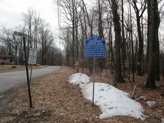
| On County Route 579 at Lt. Hooper Road, on the left when traveling west on County Route 579. |
| On Lindbergh Road at Zion Road, on the right when traveling south on Lindbergh Road. |
| On Beaver Avenue at Dewey Avenue, on the right when traveling west on Beaver Avenue. |
| On Main Street at East Street, on the left when traveling east on Main Street. |
| On Beaver Avenue, on the right when traveling west. |
| On County Route 519, on the right when traveling south. |
| On County Road 519, on the right when traveling north. |
| On Kingswood Road (County Route 519) at Oak Summit Road, on the right when traveling north on Kingswood Road. |
| On Kingwood Road (County Route 519) at Oak Summit Road on Kingwood Road. |
| On Kingwood Road (County Road 519) 0.1 miles south of Barbertown - Point Breeze Road, on the right when traveling north. |
| On New Jersey Route 173 at Mine Road, on the right when traveling east on State Route 173. |
| On New Jersey Route 173 at milepost 6.9 at Mine Road, on the right when traveling west on State Route 173. |
| On Mountain View Road, on the right when traveling west. |
| On Church Street (County Road 579 at milepost 37) at North Street, on the right when traveling north on Church Street. |
| On Church Street (County Route 579) at Brunswick Avenue, on the right when traveling east on Church Street. |
| On Main Street (County Route 512) at County Route 513, on the right when traveling east on Main Street. |
| On Raritan River Road, on the right when traveling north. |
| On Pleasant Grove Road, on the right when traveling north. |
| On Musconetcong River Road at Port Colden-Changewater Road, on the left when traveling south on Musconetcong River Road. |
| On Musconetcong River Road at Port Colden-Changewater Road, on the left when traveling south on Musconetcong River Road. |
| On Cherryville Road at Cherryville - Stanton Road, on the right when traveling north on Cherryville Road. |
| On Pittstown Road at Interstate 78, on the right when traveling south on Pittstown Road. |
| On Greyrock Road near Beaver Avenue, on the right when traveling north. |
| On Center Street at Leigh Street, on the right when traveling west on Center Street. |
| On Center Street, on the right when traveling west. |
| On Main Street, on the left when traveling east. |
| On Main Street, on the left when traveling east. |
| On Leigh Street at Center Street, on the left when traveling south on Leigh Street. |
| On W. Main Street (New Jersey Route 173), on the right when traveling east. |
| On Camp Buck Road, on the right when traveling east. |
| On Cokesbury Road, on the right when traveling north. |
| On U.S. 202-31 at milepost 9.6, on the right when traveling south. |
| On New Jersey Route 31 at milepost 13.6,, 0.4 miles east of County Route 579, on the right when traveling south. |
| On County Route 513 at County Route 519, on the right when traveling east on County Route 513. |
| On County Route 519 at Mount Pleasant Road, on the right on County Route 519. |
| On Old Turnpike Road (County Route 517), on the right when traveling south. |
| On Old Turnpike Road (County Route 517) south of Beacon Light Road, on the right when traveling south. |
| On Kuhl Road, on the right when traveling east. |
| On North Main Street, 0.1 miles north of East Main Street, on the right when traveling north. |
| On Mine Street just east of Shields Ave., on the right when traveling east. |
| On Park Avenue, on the right when traveling south. |
| On New Jersey Route 31, 0.1 miles north of Walter E. Foran Blvd., on the right when traveling north. |
| On U.S. 202 at milepost 8, on the right when traveling north. |
| On Church Street, on the left when traveling north. |
| On New Jersey Route 12 at Mine Street, on the right when traveling west on State Route 12. |
| On N. Main Street, on the left when traveling north. |
| On Old York Road (New Jersey Route 613 at milepost 1.2), on the right when traveling north. |
| On Main Street, on the right when traveling north. |
| On River Road, on the right when traveling west. |
| On Main Street, on the right when traveling south. |
| On Barton Hollow Road, on the right when traveling north. |
| On New Jersey Route 12, on the right when traveling west. |
| On 3rd Street, on the right when traveling east. |
| On Bridge Street, on the right when traveling east. |
| On Trenton Ave. (New Jersey Route 29) just south of S. Washington St., on the right when traveling south. |
| On Frenchtown - Everittstown Road (County Route 513) 1.3 miles west of Palmyra Corner Road, on the right when traveling south. |
| On Black Brook Road at Hackett Road, on the left when traveling north on Black Brook Road. |
| On Fountain Grove Road, on the right when traveling west. |
| On Main Street, on the right when traveling north. |
| On Hunt Place, on the left when traveling east. |
| On Anthony Road, 0.9 miles east of Hollow Road, on the right when traveling west. |
| On Race Street, on the right when traveling west. |
| On Hamden Road, 0.1 miles south of Lower Landsdown Road, on the right when traveling south. |
| On Hamden Road, on the left when traveling east. |
| On Sidney School Road at Landsdown Road, on the left when traveling south on Sidney School Road. |
| On Railroad Avenue at Main Street, on the left when traveling south on Railroad Avenue. |
| On Main Street at New Jersey Route 31, on the right when traveling north on Main Street. |
| On Valley Road, on the right when traveling west. |
| On Church Street, on the right when traveling north. |
| On Van Syckles Road when traveling west. |
| On W Main Street (County Route 513), on the right when traveling south. |
| On Washington Avenue, on the right when traveling north. |
| On Main Street at McDonald Street, on the right when traveling north on Main Street. |
| On Van Syckles Road, on the right when traveling west. |
| On High Bridge - Califon Road (County Route 513), on the right when traveling south. |
| On Rileysville Road at Mountain Church Road, on the right when traveling south on Rileysville Road. |
| On Kingwood-Stockton Road (County Road 519), on the right when traveling south. |
| On Kingwood Road (County Route 519) at Byram - Kingwood Road, on the right when traveling north on Kingwood Road. |
| On N. Union Street at Church Street, on the right when traveling south on N. Union Street. |
| On George Washington Road, on the left when traveling west. |
| On N. Main Street, on the right when traveling north. |
| On N. Main Street (New Jersey Route 29), on the right when traveling south. |
| On New Jersey Route 179 at Music Mountain Blvd., on the right when traveling south on State Route 179. |
| On Bridge Street at Station Court, on the right when traveling east on Bridge Street. |
| On Mt. Hope Street at Canal Street, on the right when traveling west on Mt. Hope Street. |
| On Brunswick Road (County Route 518) 0.2 miles east of Hewitt Road, on the right when traveling east. |
| On Main Street at U.S. 22, on the right when traveling east on Main Street. |
| On Brunswick Avenue, on the right when traveling west. |
| On Petticoat Lane, 0.1 miles south of East Main Street, on the right when traveling north. |
| On Petticoat Lane at East Main Street, on the right when traveling south on Petticoat Lane. |
| On County Route 614 at Schick Road, on the right when traveling west on County Route 614. |
| On Locktown Sergeantsville Road at Locktown School Road, on the right when traveling south on Locktown Sergeantsville Road. |
| On Water Street at Park Lane, on the right when traveling south on Water Street. |
| On Bridge Street at Railroad Avenue, on the right when traveling west on Bridge Street. |
| On Bridge Street, on the right when traveling west. |
| On New Jersey Route 179 at Mt. Airy Village Road, on the right when traveling north on State Route 179. |
| On Mt. Pleasant - Everittstown Road, on the right when traveling south. |
171 entries matched your criteria. The first 100 are listed above.
The final 71 ⊳