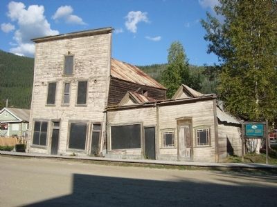
[English] In Dawson City’s history, permafrost ranks second only to fire as the bane of buildings. These three structures, dating from 1901, illustrate what can happen when heated buildings are placed on frozen ground; the frost melts, mixing water . . . — — Map (db m49305) HM
The Arctic Brotherhood was a fraternal organization formed onboard the steamer Seattle while anchored at Skagway. In 1901 Camp #4 Dawson City built a fraternity hall, known as the Arctic Brotherhood Hall to host their meetings as well as uphold . . . — — Map (db m49348) HM
[English:]
The BNA, which opened Dawson City’s first bank in a tent in 1898, moved into these premises in 1899. By providing the essential services of assaying, buying and shipping gold, it helped integrate the local currency of dust and . . . — — Map (db m44857) HM
[English] This building stands as a testament to the way frontier businesses changed and adapted to new realities. It began life in 1899 as the two storey Great Northern Hotel, to service the needs of a rapidly growing population. By 1907, as the . . . — — Map (db m49304) HM
[English] The Dawson Daily News moved into this building in 1910, the sole survivor among 7 gold rush newspapers. It provided Dawson City with a window to the outside world and remained a profitable business until the early 1920s. Thereafter, it . . . — — Map (db m49301) HM
[English] Built for Dr. Brown, a dentist, in 1902, this attractive little bungalow was tangible proof that affluent residents had confidence in the future of Dawson City and were willing to put down roots. While this may have been somewhat . . . — — Map (db m49345) HM
[English] Like other grocers at the turn of the century, Harrington provided a cosmopolitan clientele with every conceivable foodstuff, from beans to truffles. This was made possible by the coincidence of improved transportation systems with new . . . — — Map (db m49303) HM
[English] Built in 1899, this warehouse was taken over by the Klondike Thawing Machine Company 1n 1913. The growing hardware company was it the process of buying out other firms and expanding its line of goods even as Klondike gold claims were . . . — — Map (db m49302) HM
This fine two storey house, built in 1901, was owned by Henry C. Macaulay, Dawson City’s first mayor. Subsequently, it housed such affluent individuals as a merchant, a Territorial Commissioner, a surveyor, and senior management of the . . . — — Map (db m49343) HM
While this building dates from 1899, it did not become Mme. Tremblay’s, a dry goods and novelty shop, until 1913. Émillie Tremblay had first come to the territory as a young French Canadian bride in 1895 with her husband Jack. After 15 . . . — — Map (db m44933) HM
[English] This handsome residence was built in 1902 for the commanding officer of the North West Mounted Police. It lent dignity, authority and a degree of permanence to the presence of law and order in Dawson City. While the police presence was . . . — — Map (db m49341) HM
[English] One of the complex of four warehouses that covered an entire city block in 1898, this and numerous other warehoused like it provided the life blood of Dawson City. For four months a year, the river was open for shipping and in the ensuing . . . — — Map (db m49346) HM
[English:]
“Arizona” Charlie Meadows, showman and self-made heroic figure built a lavish structure in 1899 to prospect gold directly from the miner’s pokes. Hugely successful over its first winter, the theatre offered vaudeville acts, . . . — — Map (db m44890) HM
[English:]
Prime Minister Laurier himself recognized the need to link the Klondike with the rest of the country. In 1900, he urged that the building of a Post Office “...be proceeded with at once.” As the first substantial building erected by the . . . — — Map (db m44936) HM
Credited with saving many lives, Father Judge was one of the true heroes of the Klondike, serving the area from May 1897 until his death January 16, 1899. In this short period he built St. Mary’s Hospital, a church and residences, doing much of the . . . — — Map (db m70916) HM
Within 5 years of Robert Service's departure in 1912, the local press referred to his rented cabin as a “shrine”. It became Yukon’s foremost tourist attraction virtually from the day it was abandoned. Maintained, altered and . . . — — Map (db m42695) HM
Opened as a boarding house and laundry in 1902, the building was taken over by Mathilde “Ruby” Scott in 1935. For over 27 years, this former Paris Madame operated a brothel here, finding a ready clientele in the seasonal workers from the . . . — — Map (db m44887) HM
[English] This substantial Presbyterian Church was a reflection of the prosperity and commitment of the congregation it served. Erected in 1901, it boasted a pipe organ and carved oak pews that could accommodate 600. The church bore the . . . — — Map (db m49307) HM
[English:] This structure, built in 1900, is all that remains of a larger complex that included a warehouse and dock. At the time of the gold rush and for years afterwards, the riverfront was the transition point between Dawson City and the rest of . . . — — Map (db m44859) HM
“What fools we mortals be.”
About 150 people, “many of whom were ladies”, attended the first formal gathering to see the midnight sun on June 21, 1899. Weary mountaineers were greeted with a selection of nuts, candies and soft drinks at suitably . . . — — Map (db m44762) HM
Dedicated to the Klondike Gold Miners past, present and future in recognition of their contributions to Dawson City and the Klondike Region.
In 1896, gold was discovered on Rabbit Creek (later known as Bonanza Creek) by Skookum Jim, George . . . — — Map (db m49349) HM
[English] When it was built in the fall of 1898, the Binet Block stood at the southern end of the business district extending north to King Street. A two-storey log building with a facade of milled lumber, it was typical of commercial structures . . . — — Map (db m49306) HM
The Yukon Saw Mill Company was one of the first to cut timber in the Klondike, registering its first timber lease in March of 1898. At its peak, the company’s machine shop was the largest north of Vancouver, and its lumberyard stretched over three . . . — — Map (db m44761) HM
The church was built in 1954 by Father E. Morriset O.M.I. the first Catholic priest to preach the gospel in the area. Resources were scarce and Father Morisset ingeniously converted an old Quonset but, which had been used by the American Army during . . . — — Map (db m302678) HM
Built in 1944, this was the first church northwest of Whitehorse on the new Alcan highway. Father Morisset, the auxiliary chaplain to the U.S. Army at the road construction camps, was asked by the local residents to start a mission and day . . . — — Map (db m302653) HM
Scotia Mac
"Scotia Mac" John McDonald joined the BYN Co. after working on several steamers for numerous organizations starting in 1896, mostly on Kootenay Lake in British Columbia.
In 1902, MacDonald worked on the sternwheeler . . . — — Map (db m248717) HM
"To Dad,
Well, here were are, sailing up the Taku Arm, in the wilderness of the Yukon, on the quaintest old stern-wheeler steam-boat you ever saw.
The plumbing is the bowl and pitcher type, but it is all so much fun."
The southern . . . — — Map (db m248654) HM
The first steamboat, tested in 1807, was heralded as "the wonder of the age". The technology was developed and refined until a powerful steam engine, mounted on the light frame construction of a shallow hull, drove a side or stern-wheel vessel. This . . . — — Map (db m248716) HM
This reproduction lifeboat and three others were built in the mid-1980s as part of the SS Tutshi restoration project. The Tutshi had space for four lifeboats on the boat deck (so-named for the presence of the lifeboats). Each lifeboat . . . — — Map (db m248660) HM
The Carcross and Tagish people gathered at Tagiush and the mouth of the McClintock River to trade and fish and camped by the Natasaheen Ruver when the Woodland Caribou migrated across the river.
The Klondike Gold Rush brought tremendous . . . — — Map (db m248719) HM
The Yukon steamers were all sternwheelers rather than sidewheelers. The paddlewheel at the rear of the boat allowed grounded steamers to wash the sand away from the hull by reversing their engines. Sternwheelers had a narrow beam enabling them to . . . — — Map (db m248668) HM
During World War II, Carcross played an important role in Alaska Highway construction. The connection here between the White Pass rail and water transportation systems gave the U.S. Army access to the Yukon’s interior.
By early 1942, Carcross . . . — — Map (db m68899) HM
The Caribou Hotel is one of the oldest buildings in the Southern Lakes Region and is one of Yukon's longest-operating hotels.
The Yukon Hotel was moved here from Bennett City and named Anderson Hotel, Carcross/Tagish First Nation citizen . . . — — Map (db m248664) HM
The first southern lakes sternwheelers were constructed on the shores of Lake Bennett during the Klondike Goldrush. They carried freight and passengers from Bennett City to Canyon City at the head of Miles Canyon just upstream from present-day . . . — — Map (db m248729) HM
English:
"Skookum" Jim, a Tagish of the Dakhławèdí
clan and the Wolf moiety, found a nugget on
Rabbit (Bonanza) Creek in August 1896 that
began the Klondike Gold Rush and changed
the history of the Yukon. He made . . . — — Map (db m93750) HM
Welcome to the Tagish Valley Trail. The Carcross/Tagish people have traditions such as the moiety and clan system that have been followed for thousands of years and are still honored today. For centuries they have lived in this region, an area of . . . — — Map (db m248662) HM
The SS Tutshi was built by the British Yukon Navigation Company in 1917 at Carcross and was pulled out of service in 1955. The Yukon Government purchased the SS Tutshi in 1971 and began an ambitious restoration project that was . . . — — Map (db m248655) HM
Tagish Lake contains a number of reefs and sand bars especially at Golden Gate where Taku Arm and Taku Inlet meet.
Tagish and Bennett lakes are prone to fierce winds and in the fall of 1933, a heavy wind blew the Tutshi broadside against . . . — — Map (db m248722) HM
Construction of the WP & YR railway began on May 28, 1898, at Skagway and took 26 months to complete from Tidewater to Alaska. to Whitehorse, Yukon.
The rail line reached Bennett City, on the south end of Lake Bennett, on July 6, 1899. Land was . . . — — Map (db m248653) HM
The pieces rescued from the 1990 fire represent the hundreds of meters of steam line and equipment that made the SS Tutshi an efficient and comfortable vessel.
Steam Winch:
A twin-cylinder horizontal steam winch was installed on the SS Tutshi . . . — — Map (db m248720) HM
The Dakl'aweidí and Yanyeidí clans of the Wolf moiety, and the Deisheetaan, Gaanaxteidí, Ishkahíttaan, and Kookhíttaan clans of the Crow moiety welcome you to the Traditional Territory of the Carcross/Tagish First Nation. The Tagish Valley Trail . . . — — Map (db m248659) HM
The little engine known as the DUCHESS was once part of a matched set. She and her partner, the DUKE, were built in September 1878 for the Dunsmuir and Diggie Company.
For a time the two little locos hauled coal for the Wellington Colliery . . . — — Map (db m248651) HM
On December 24th, 1909, fire swept through Carcross and destroyed many of the prominent buildings such as the depot, Caribou Hotel and General Store.
The Caribou had been an established hotel for some time and was once owned by Dawson Charlie, . . . — — Map (db m248652) HM
Construction of the White Pass & Yukon Railway began on May 27, 1898 at Skagway, Alaska during the height of the great Klondike Gold Rush.
Undaunted by those who said the railway could not be built a small group of devoted White Passers composed . . . — — Map (db m49366) HM
The golden spike was driven to mark the completion of the White Pass & Yukon Route Railway on July 29, 1900. It was the beginning of a fully integrated rail transportation system – which grew to include lakes & river steamboats, stage lines, . . . — — Map (db m72917) HM
The story of the White Pass & Yukon Route railway really begins in April of 1898, with a chance meeting in a Skagway saloon. A group of British financiers named the Close Brothers had acquired the charters that would allow them to build a railway . . . — — Map (db m248650) HM
White Pass and Yukon Railway
Completed in 1900
A tribute to the American and Canadian engineers who conceived, designed and
constructed the 110 mile narrow gauge railway to develop the
Yukon gold fields. The railway has since . . . — — Map (db m282328) HM
Construction of the WP & YR railway began on May 28, 1898, at Skagway and took 26 months to complete from Tidewater to Alaska. to Whitehorse, Yukon.
The rail line reached Bennett City, on the south end of Lake Bennett, on July 6, 1899. Land was . . . — — Map (db m248728) HM
[English:] The Tatshenshini River
The Tatshenshini River, known as Shawshe Chu in the Southern Tutchone language, begins in northwestern British Columbia and flows nearly 200 kilometers through the traditional territory of the . . . — — Map (db m49612) HM
The names Robert Henderson, Skookum Jim, Tagish Charlie and George Carmack are inextricably linked to the discovery of gold on Bonanza Creek. Henderson was first to systematically explore the gold bearing potential of the region, only to . . . — — Map (db m44702) HM
Yukon Highway No. 9 began as a pack trail out of Dawson City shortly after the Gold Rush. It serviced Sixtymile and neighbouring gold creeks. The trail was gradually improved and came to be known as Ridge Road.
In the 1930s, the road was . . . — — Map (db m298816) HM
The territorial government contracted the White Pass & Yukon Route (WP&YR) to build a winter road from Whitehorse to Dawson in 1902. The company had the winter mail contract, and used its Royal Mail Service coaches to carry passengers, baggage and . . . — — Map (db m108780) HM
The Northern Tutchone who now live at Pelly Crossing traditionally led a semi-nomadic life in the lower Pelly River area.
When Robert Campbell built Fort Selkirk, the site was already a meeting place for trading with the coastal Tlingit. The . . . — — Map (db m108781) HM
High water on the Stewart River peaks in late May and early June. The water level then declines for the rest of the summer to the point where only sternwheelers with a very shallow draft could navigate its swift current and shifting channels. . . . — — Map (db m108782) HM
West Dawson was settled c. 1899 by people wanting to avoid overcrowding and typhoid outbreaks in Dawson. Farms also became established and later, as mining in the Sixtymile area increased, a link with Dawson became necessary. In 1902 a ferry guided . . . — — Map (db m44711) HM
In 1942, during the construction of the Alaska Highway, the United States Army Corps of Engineers erected mileage posts at their camps that listed places, distances and directions in the Yukon, other Canadian cities, cities within the United . . . — — Map (db m72697) HM
(left marker)
At this site on 1 April 1946
the United States Army
officially handed over
the Alaska Highway and
associated facilities to
the Canadian Army
This plaque is dedicated
to the those who built and cared
for . . . — — Map (db m42832) HM
This immense slab of native copper weighs 2590 pounds or 1175 kilograms. In 1905, prospectors found the copper on the upper White River, 250 miles northwest of Whitehorse. This is the Yukon’s largest copper nugget, possibly a Canadian record. . . . — — Map (db m42727) HM
The Reverend Richard Bowen and his wife, veterans of the Klondike Goldrush arrived here August 1, 1900 at the call of Bishop Bompas. Bowen immediately undertook with volunteer labour to build this church of logs and held his first service on October . . . — — Map (db m42864) HM
English:
The largest vessel ever to ply the Canadian portion of the Yukon River, this sternwheeler was built by the British Yukon Navigation Co. and launched at Whitehorse in 1937 to replace her namesake, which sank the year before. . . . — — Map (db m42699) HM
English:
Built at the time of the Klondike Gold Rush, the 177 km narrow gauge railway was the heart of the Yukon transportation system for over 80 years. Completed in 1900, it linked the tidewater port of Skagway in Alaska with Whitehorse, . . . — — Map (db m42863) HM