On East Pearl Street at Depot Street, on the left when traveling east on East Pearl Street.
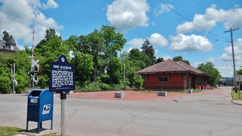
Perhaps nothing contributed more to the growth of Wellsville than the arrival of the Erie RR in 1851. The railroad brought many new families and businesses to our area and the population almost doubled in size. The old depot was on Loder Street at . . . — — Map (db m175134) HM
On North Main Street just north of Jefferson, on the right when traveling north.
In 1832 a group of leaders met at Van Buren's Tavern to choose a name for their community. They selected "Wellsville" after Gardiner Wells who was one of the first settlers and the largest landowner. Wells built the first log house on Main Street . . . — — Map (db m175133) HM
On South Main Street just north of West Dyke Street, on the left when traveling north.
From 1845 to 1905, Wellsville was home to several tanneries that were reported to be the largest in the world. They provided work for hundreds of people in lumbering and tanning. Hemlock bark was used in the tanning process and was stacked in huge . . . — — Map (db m175132) HM
Near Jungle World Road west of Bronx River Parkway, on the right when traveling west.
Grazing, wallowing, and other bison behaviors turn out to be beneficial for plants and animals.
As seen on "The Zoo!"
Keepers noticed that one of the zoo's bison calves developed a bowed leg, caused by one leg bone growing faster than . . . — — Map (db m193265) HM
On East 163rd Street east of Melrose Avenue, on the right when traveling east.
What was here before?
A Scottish surveyor named the Bronx neighborhood of Melrose in tribute to Sir Walter Scott's (1771-1832) popular work Melrose Abbey. This part of the southeastern Bronx was part of the land granted to the Morris . . . — — Map (db m241502) HM
On East 161st Street west of Courtlandt Avenue, on the right when traveling west.
This park at the intersection of Courtlandt Avenue, East 161st, and East 162nd Streets in the Bronx neighborhood of Melrose takes its name from the nearby railroad station.
A Scottish surveyor named the Bronx neighborhood of Melrose as a . . . — — Map (db m241504) HM
On Saint Ann's Avenue at East 139th Street, on the right when traveling south on Saint Ann's Avenue.
Padre Plaza honors Father Roger Giglio (1943-1990), founder of St. Benedict the Moor Neighborhood Center. A native of Woburn, Massachusetts, Father Giglio was ordained in 1970 and served as the director of the Christian Formation Retreat Center . . . — — Map (db m209734) HM
On East 140th Street just west of Brook Avenue, on the right when traveling east.
This playground is named for the Saw Mill Creek, also known as the Mill Brook, which once flowed by this parkland. The creek originated in Gates Place in the North Bronx, ran along what is now Brook and Webster Avenues, and emptied into the Bronx . . . — — Map (db m209723) HM
On Mosholu Avenue at West 254th Street, on the left when traveling north on Mosholu Avenue.
Vinmont Veteran Park serves as a memorial honoring local veterans who served their country in past wars. the park is named after both the surrounding Vinmont neighborhood and adjacent Vinmont Road. These, in turn, are named after Robert C. . . . — — Map (db m193300) HM
On Hugh J. Grant Circle at Metropolitan Avenue on Hugh J. Grant Circle.
What was here before?
This site was once a tract of farmland owned by the Pugsley family in the early 19th century. The land became part of the Cobb and Larkin family farms in the late 1800s, until the City acquired it incrementally in the . . . — — Map (db m238051) HM
On June 27, 1654, beneath a nearby oak, Thomas Pell signed a treaty with Siwanoy Sachems acquiring the Manor of Pelham and pledging “mutual peace and love be maintained.” Fire destroyed the tree in 1906. — — Map (db m192136) HM
Located at the convergence of the Chenango and Susquehanna Rivers, Confluence Park is the hub of the Two Rivers Greenway and a meeting of Binghamton’s past and present.
[captions] The South Washington Street Bridge, shown here, was designed by . . . — — Map (db m198124) HM
The valleys of the Upper Susquehanna River were natural routes for Indians, traders and settlers. Oquaga, near Windsor, was an Indian fur-trading post, and became an objective of the Sullivan-Clinton Campaign of 1779. From a dam at the outlet of . . . — — Map (db m35164) HM
On Second Street, on the right when traveling west.
Set apart from Ulster and
Otsego Cos., 1797; Named
for Delaware River, which
was named for Lord Delaware,
Governor of Virginia, 1609 — — Map (db m92745) HM
On Second Street, on the right when traveling west.
This Boulder Marks The
Fort Stanwix Treaty Line
The deed from the Indians to the whites
was signed November,5 1768
The line was run in 1769
from the Delaware River almost due north
to the mouth of the Unadilla River
It afterward became the . . . — — Map (db m92769) HM
On Main Street, on the right when traveling south.
Historical Marker
Village of Deposit Incorporated 1811
Originally Cookhouse Site of John Hulce's home
First permanent settler 1789 — — Map (db m93293) HM
Revolutionary War veteran. Professor at Kings College. Deputy Secretary of State. Pioneer of Local Lands. Namesake of Harpursville and Harpur College. — — Map (db m93548) HM
On Hawleyton Road (County Route 117) at Saddlemire Road (County Route 125), on the right when traveling south on Hawleyton Road.
First called The Hemlocks.
You are here X
1. Water Powered Mill
2. Blandings Store
3. Town Hall
4. Hawleyton Creamery
5. Hawleyton ME Church and Parsonage Given by James Hawleyton
6. Lyceum Hall - Later Blacksmith Shop
7. Hawleyton . . . — — Map (db m220880) HM
On Death Valley Road at Fredericks Road, on the right when traveling south on Death Valley Road.
Cautionary Tales of Murders,
Hangings, Drownings, and
Scattered Bones near This
Road Have been Told By
Residents for Generations.
— — Map (db m202081) HM
First People in the Valley
The earliest inhabitants of this Susquehanna River valley were here more than 400 years ago. A 1614 map drawn by Dutch traders shows the existence of a village spelled Ogehage. Over time- and many different . . . — — Map (db m94489) HM
David Hotchkiss founder, ca 1787,
gave village green to
Presbyterian Society 1802.
Town of Windsor-1807
Village incorporated 1897 — — Map (db m93053) HM
On New York State Route 242, 0.1 miles west of Pittsburgh Buffalo Highway (U.S. 219), on the right when traveling west.
10/6/1815, Grove Hurlburt bought lot 57, 150 acres for $525.00, built a log house, the first dwelling in Ellicottville, New York — — Map (db m175141) HM
On Salamanca Sugartown Road (County Route 98) 0.1 miles east of Cadiz Road (Route 69), on the left when traveling west.
The first settlers arrived here in 1806 and this area was called Conrad's Mills. Later the name was changed to Cadiz. Dairy farming was the main occupation in this tiny hamlet within the Township of Franklinville. The famous Ontario Knife Company . . . — — Map (db m86625) HM
On Freedom Road (County Route 23) at Osmun Road, on the right when traveling east on Freedom Road.
Welsh Settlement circa 1840, immigrants from Wales settled in Freedom and nearby towns and contributed to the economic, religious, and social life of the area. — — Map (db m86648) HM
On Rock City Road (New York State Route 16) 0.5 miles east of Knapp Creek Road, on the left when traveling east.
The Settlement of Knapp Creek, formerly known as Knapps Creek, was a genuine boomtown in the early days of the Bradford Oil Field, beginning about 1877. It was on a narrow gauge railroad and later an electric street car line. The town boasted a . . . — — Map (db m60154) HM
On Roszyk Hill Road (County Route 16) 0.2 miles east of Maple Avenue (County Route 62), on the left when traveling east.
Dedicated to our Revolutionary War Veterans and The Early Residents buried in Gulf Cemetery Nelson Lingenfelter 1821 1842; Charles Lingenfelter 1822 1841; Darius C. Brace; Amanda Chatfield 1767 1829; Hannah Brown 1727 1809 ; Andrew . . . — — Map (db m133041) HM WM
On South Street just west of S. Barry Street, on the left when traveling east.
In recognition of Olean's 200th birthday, we dedicate this prehistoric Olean conglomerate rock. In 1804 Major Adam Hoops bought a large parcel of land at Olean Point and founded our city. We celebrate that occasion and honor all of our citizens and . . . — — Map (db m60155) HM
On South Union Street (New York State Route 16) just south of E. State Street (New York State Route 417), on the right when traveling north.
In Memory of Major Adam Hoops
A soldier of the Revolution and founder of Olean, N.Y.
1804
and to keep in remembrance the patriots of the War for Independence who are buried in Cattaraugus County, New York — — Map (db m60156) HM
On Broadway Road (County Route 4) 0.2 miles north of Point Peter Road, on the left when traveling south.
Ahaz Allen Pioneer settler in town of Persia in 1810. Built first saw and grist mill, bridge, frame house, Forty Rd. Gave land for cemetery in 1836. — — Map (db m104212) HM
On Allegany State Park Route 1, 0.2 miles south of the Red House Store and campground, on the right when traveling north.
On this site in 1859, the first log house was built on what is now known as Allegany State Park. It was built by Giles Stoddard Jr., and his wife Sarah Niles Card on 132 acres then known as Stoddard's Hollow. Giles Stoddard Jr. helped fell the . . . — — Map (db m98119) HM
On New York State Route 16, 0.2 miles south of New York State Route 39, on the left when traveling south.
Erie Indians were the first inhabitants of this region. In 1654, they were driven out by the Senecas who occupied several sites along the banks of Cattaraugus Creek. The Cattaraugus, the principal stream of many that divide the Cattaraugus Hills, . . . — — Map (db m86681) HM
On Genesee Street, 0.1 miles east of James Street, on the right when traveling east.
Hon. Theodore Medad Pomeroy (1824-1905) was born in Cayuga to Rev. Medad Pomeroy and Lillian Maxwell. His father moved the family to Elridge where Theodore studied at Munro Academy under Lemuel S. Pomeroy. A graduate of Hamilton College, Theodore . . . — — Map (db m88309) HM
On East Main Street (New York State Route 370) at South Street (New York State Route 34), on the right when traveling east on East Main Street.
Jakway's Corners Village formerly so called from Dr. John Jakway settling 1809, associate of Ethan Allen. Platt Titus first settler 1805. — — Map (db m83764) HM
On West Main Street (New York State Route 370) 0.2 miles west of North Street (New York State Route 34), on the right when traveling west.
Old Mill First grist mill in Ira. Built in 1818 by John Hooker, associate of Ethan Allen. Mill was old part of present building. — — Map (db m83777) HM
On Atwater Road (County Road 32) at Bartnick Road, on the right when traveling east on Atwater Road.
Settled Ca.1820 at intersection of 4 military tracts with stores, church, post office and school on direct route to Cayuga Lake — — Map (db m172110) HM
On Main Street (New York State Route 370) 0.1 miles east of Bonta Bridge Road (County Route 18B), on the right when traveling east.
Cato Four Corners Geo. Loveless and Abel Pasko first settlers in 1804. Jesse Elwell and Abner Hollister settled in 1805. Called Meridian since 1849 — — Map (db m83812) HM
On Main Street (New York State Route 370) 0.1 miles east of Bonta Bridge Road (County Route 18B), on the right when traveling east.
For many years a Magistrate of this Town & County. The founder of this Village and this Church which he served with christian fidelity as ruling Elder from the time of its organization until his death. Born at Glastonbury Conn. Sept. 26, 1782, . . . — — Map (db m83813) HM
On New York State Route 38A at Dresserville Road, on the right when traveling north on State Route 38A.
Built 1812. Judge Walter Wood
Co-founder Cayuga Academy
1801. First Judge Cayuga County
1810-17. Taught Pres. Fillmore
Law 1819-21, while living here. — — Map (db m205461) HM
On NY-38A (New York State Route 38A), on the right when traveling south.
Set off from Sempronius in 1833. First settled 1792. Named from Elder Robt. Niles, a pastor of the 1st Baptist Church of Sempronius — — Map (db m230524) HM
Near Utica Street (New York State Route 31), on the right when traveling east.
Erie House
The 1890s Erie House saloon was built by Italian immigrant brothers near Lock 52 for canalers, drydock workers, and the many Italians farming the rich mucklands. In this 1901 view, the brothers, Peter and Salvatore Van Detto, stand . . . — — Map (db m182181) HM
The Erie Canal in Port Byron When the original Erie Canal or "Clinton's Ditch" was completed here in 1819, Port Byron was transformed from a frontier settlement to a thriving canal town. Indeed, the local citizens were so hopeful with the new . . . — — Map (db m103580) HM
On New York State Route 104A at MacNeil Road, on the left when traveling north on State Route 104A.
Sterling Valley First settlement made here 1805 by Peter Dumas, a soldier with Lafayette. Earlier called Coopers Mills after John Cooper 1810 — — Map (db m79783) HM
On New York State Route 104A near Center Road (County Route 98).
Town of Sterling Named after a Revolutionary officer, Lord Wm. Alexander Sterling. Set off from Cato 1812. First grist and saw mill built here in 1813 — — Map (db m79753) HM
On West Cayuga Street (New York State Route 38) west of Keeler Street, on the right when traveling north.
Owasco Flats
Site of Indian Village.
Land Cultivated Prior to
White Settlements.
Neighboring Settlers Came
to Harvest Hay 1789 - 1790 — — Map (db m213823) HM
On South Seneca Street (New York State Route 34) at Furnace Street, on the right when traveling north on South Seneca Street.
Cayuga County Weed's Basin named after Elihu and Edward Weed who constructed a basin on Old Erie Canal 1821. P.O. established 1822 Weedsport Inc. village 1831 Village of Weedsport — — Map (db m83727) HM
On Chautauqua-Stedman Road (County Route 33) 0.3 miles north of Webber Road, on the left when traveling north.
Pioneer Home June, 1806 William and Mehitable Wing Prendergast and family settled in a log house. Sons notable in county history. — — Map (db m117534) HM
On Main Road (U.S. 20) at Erie Street, on the right when traveling west on Main Road.
First non-Indian settler of Hanover and Chautauqua County, built his home nearby in 1796. Indian friend, farmer, fiddler, and worker on the HLC survey. — — Map (db m64673) HM
On North Main Street at West 4th Street, on the left when traveling north on North Main Street.
"Keyes' Carpenter Shop" Here in 1816, Royal Keyes, cabinet maker, erected a small carpenter shop. In its second story he made simple articles of furniture for the pioneer community. From this small beginning grew the great furniture industry of . . . — — Map (db m94864) HM
Near South Main Street at Shearman Place, on the right when traveling north.
Before white men came to this area the Indians blazed a trail between Lake Erie and Lake Chautauqua over which they, early explorers and settlers, portaged their canoes. At the Chadakoin River rapids the canoe was portaged again. Here is where the . . . — — Map (db m64674) HM
On North Main Street at West 2nd Street, on the right when traveling south on North Main Street.
In a small house which stood here, James Prendergast founder of Jamestown lived from 1815 to 1836. Judge Prendergast was born in Pawling, New York, 1764 and died 1846 in Kiantone. To his vision, his enterprise his Christian character and his many . . . — — Map (db m94839) HM
On North Main Street at West 4th Street, on the left when traveling north on North Main Street.
Keyes' Carpenter Shop Here in 1816 Royal Keyes cabinet maker erected a small two-story carpenter shop. In its second story he employed his spare time in making simple articles of furniture for the pioneer community. From this small . . . — — Map (db m94865) HM
Near Pine Street just south of East 4th Street, on the left when traveling south.
Here at the home of Silas Shearman pioneer settler and ardent abolitionist was the principal Jamestown “station” of the Underground Railroad where in the late fifties escaping slaves from the south were sheltered and assisted on their way to . . . — — Map (db m177999) HM
On Frewsburg Road (U.S. 62) 0.2 miles south of Jamestown Road (New York State Route 394).
First commercial enterprise in southeastern Chautauqua County
Doctor Thomas Ruston Kennedy built first mill October 1805 after purchase of 3000 acres in the area which became the Town of Poland — — Map (db m60146) HM
On East Chautauqua Street (New York State Route 430) at South Erie Street (New York State Route 394), on the right when traveling east on East Chautauqua Street.
Chautauqua Lake, eighteen miles long and one to three miles wide, has as its outlet a branch of Connewango Creek, a tributary of the Allegheny River. This gives Chautauqua an indirect connection with the Gulf of Mexico by way of the Ohio, and . . . — — Map (db m64687) HM
2073 entries matched your criteria. Entries 101 through 200 are listed above. ⊲ Previous 100 — Next 100 ⊳