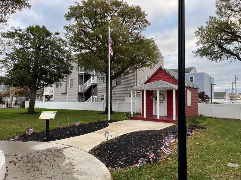
On East Burk Avenue west of Pacific Avenue, on the left when traveling west.
This park is home to the first school in Holly Beach in 1882 at the age of 15, Mary Van Valin, the daughter of the Mayor started a one room school for ten students. The first school was located at Taylor and Beach Avenues. This Mini House was . . . — — Map (db m209327) HM
On East Burk Avenue west of Pacific Avenue, on the left when traveling west.
This maypole
erected here in 1886
to serve the children of
Holly Beach School
is dedicated to the memory of
a loyal citizen and educator
Lanning Myers
1882 - 1945
First High School Principal
1906 - 1924 . . . — — Map (db m209330) HM
Endowed as free school for poor children by Zachariah Barrow. Oldest educational building in Cumberland Co., it served until the advent of public supported learning. Militia trained here-1812. — — Map (db m92313) HM
On North 2nd Street (New Jersey Route 47) at East Main Street (New Jersey Route 49), on the right when traveling north on North 2nd Street.
The Millville Bank was built in 1857. It was the city's first banking institution, chartered by the New Jersey legislature. The masonry building was expanded in 1883.
When the bank moved to a larger site in 1908, the building became the . . . — — Map (db m153655) HM
On South 7th Street just south of East Elmer Street, on the right when traveling south.
Born in 1853 in Philadelphia, Mary J. Dunlap was awarded her medical degree in 1886 from the Woman's Medical College of Pennsylvania. Dr. Dunlap was the first female Superintendent and Medical Director for the newly established Home for . . . — — Map (db m153760) HM
Near West Parker Avenue west of Valley Street, on the left when traveling west.
Created by Columbia High School Students in 1968.
Bernard "Buzzy" Hellring, Jr. •
Jonny Hines •
Joel Silver •
Inducted into the Columbia High School Hall Of Fame - 2022 — — Map (db m212279) HM
On Maplewood Ave west of Durand Road, on the right when traveling east.
He became the first permanent schoolmaster in Maplewood in 1871 and he shaped the educational system for 20 years. A world traveler, explorer and photographer he opened the eyes of his students to the world. — — Map (db m193334) HM
On Raymond Blvd. at Park Place, on the right when traveling west on Raymond Blvd..
On May 24, 1916 the Newark Board of Education on the recommendation of Charles A. MacCall, Supervisor of Attendance and Felix Dunn of the Newark Police Department established the first School Safety Patrol in our nation. Patrol members through . . . — — Map (db m40712) HM
On Washington Place, on the right when traveling west.
The first academy in Newark was erected near this spot in 1774 by the gifts of generous citizens.
Dedicated to learning, it found, in time of war, a new mission in the cause of liberty, giving useful service as a barracks and hospital for . . . — — Map (db m6998) HM
On DeGraw Avenue, on the right when traveling south.
Built in 1893, this house served the Karr and Milburn families for more than 90 years. Lucy Karr Milburn (1895-1998), was a lifelong champion of human rights, a high school teacher, and a poet. Before World War I she marched for women's suffrage . . . — — Map (db m70172) HM
On Christopher Columbus Drive south of Bloomfield Avenue, on the left when traveling south.
The Essex County Stephen N. Adubato, Sr. Sports Complex Recognizing the spirit of a 40-year-old organization, The North Ward Center, and the vision of its founder, who built a storefront operation into a community institution. A former . . . — — Map (db m52263) HM
On Bloomfield Avenue east of Gould Street, on the right when traveling west.
On this site stood the brick Bloomfield Avenue School. Nearby and within the confines of the civic center were the previous two buildings which were removed in 1923 when the municipal center was constructed (the 1851 building was dismantled and its . . . — — Map (db m46080) HM
On Library Street at South Main Street, on the right when traveling north on Library Street.
Formed February 8, 1878 and opened its doors July 1, 1878
Thomas Bodine offered the property at Main St. and Library St. Providing a 10 year lease of $1.00 so the library could be built at Main and Library Streets. First Superintendent John . . . — — Map (db m146774) HM
On N Broad Street (County Route 551), on the left when traveling south.
This property, the home of Captain James Lawrence while attending school in Woodbury, was presented to the Gloucester County, N.J. Historical Society by George M. Beckett Edward Tonkin Bradway Fannie V. Watson Bradway James Cooper Griscom Howard . . . — — Map (db m29418) HM
On River Street at Hudson Place, on the right when traveling north on River Street.
This site was once close to the geological edge of the Hudson River. This building, CIRCA 1889, close to major transportation was once Hoboken's largest commercial structure. Built as the Second National Bank, it housed a variety of uses, most . . . — — Map (db m6881) HM
This land was a part of the Island of Hoboken which was deeded on Feb. 15, 1663 by Peter Stuyvesant, Governor of Nieuw Amsterdam, for the benefit of his sister Anna, Widow of Samuel Bayard of Amsterdam.
In 1784, these 564 acres belonging to . . . — — Map (db m6860) HM
On this site stood the Martha Institute from 1866-1999. Built on land donated by Hoboken philanthropist Martha Bayard Stevens and named in her honor, the Martha Institute served as home to Hoboken's first German-American school, the Manual Trade . . . — — Map (db m6879) HM
Near W. Main Street at Quarry Road, on the right when traveling west.
Although this tiny school house was uncluttered with even the most basic of modern conveniences, it provided a quality education.
The original school house for Hunterdon County District 31, often referred to as the Old Church School, was a . . . — — Map (db m140752) HM
1837 grist mill ground various products until 1952 when it became a cultural center. Presents visual arts exhibitions and education programs. — — Map (db m16628) HM
This 1860 frame schoolhouse stood near St Thomas' Church in Alexandria Township. It remained open until 1921. In 1974, the building was moved to the Clinton Historical Museum grounds. — — Map (db m63101) HM
On Maple Street at Main Street, on the right when traveling east on Maple Street.
Original portion of the building erected with the generous bequest made January 6, 1906 by Dr. William H. Bartles. Land for the building donated by a devoted friend of the library, Hiram E. Deats. Library building enlarged in 1939. — — Map (db m19525) HM
On New Jersey Route 31, on the right when traveling north.
This was the original site of an 1802 Log Schoolhouse. The current structure was built in 1854, and served Raritan Township as a One-Room Schoolhouse until 1949. Used as an office for The Flemington Fair and Carnival Association. — — Map (db m30949) HM
On Petticoat Lane at East Main Street, on the right when traveling south on Petticoat Lane.
In 1913, the State of New Jersey acquired 747 acres to establish a farm colony to treat the mentally ill. During World War I, inmates from the reformatory at Rahway farmed the property to provide emergency food supplies for the war effort. After the . . . — — Map (db m40766) HM
On County Route 579, on the right when traveling east.
This building served as a school from 1837 to 1871 on Old Franklin School Road. It was used as a variable storage shed on Locust Grove Road until 1977, when it was moved here and restored. Its structural frame and windows remain original to the . . . — — Map (db m94961) HM
On Quakertown Road (County Route 579), on the right when traveling east.
Attended school at the site from which this school came.
Graduate: Swarthmore College
Civil Engineer
Township Official
Boy Scout Leader — — Map (db m19530) HM
On Larison Lane, on the right when traveling west.
Conducted 1876-1909 by Dr. Conrnelius Larison.
Also publishing house for his “Fonic Speling Wurks in Orthoepy.” His old home lies to the east. — — Map (db m16697) HM
On Old York Road (New Jersey Route 179), on the right when traveling south.
Built in 1811 as a private school. In 1869 the Larison brothers, Dr. C.W. and Rev. A.B. opened their seminary at Ringoes. Building is one of the finest examples of Federal Architecture in N.J. — — Map (db m16732) HM
On South Main Street (New Jersey Route 29), on the right when traveling north.
Stockton Borough School remains the oldest continously operating public school on its original site in New Jersey. In 1827, this property was set aside for the construction of a school house. The original school building, constructed in 1832, was . . . — — Map (db m27073) HM
On River Avenue east of U.S. 202, on the right when traveling west.
Before 1813 a 16' X 16' schoolhoouse stood here. Rebuilt in 1840, it served until 1872 when a new building which has housed the town's fire company since 1954 was erected on this site. — — Map (db m35673) HM
Howell Living History Farm depicts family farm life during the first years of the 20th Century, when both crops and livestock, were raised from livelihood. The farmhouse on the property, while dating back to the early 1800’s, is used to illustrate . . . — — Map (db m94717) HM
Near Nassau Street, on the right when traveling east.
In the nation’s service. In the service of all nations. On the occasion of its 250th anniversary Princeton University here records its gratitude to its alumni for their devotion to the University and its mission of education, scholarship and . . . — — Map (db m44846) HM
On Nassau Street at Palmer Square, on the right when traveling west on Nassau Street.
On the occasion of the 250th anniversary of Princeton University, the area communities express appreciation to the University for its contribution to their cultural, intellectual and economic vitality. — — Map (db m44851) HM
Betsey Stockton (1798-1865) began life as a slave for the prominent Stockton family in Princeton. When she gained her freedom at the age of 20, she became a missionary, traveling to Hawaii (Sandwich Islands), Canada and Philadelphia, teaching school . . . — — Map (db m94762) HM
Near Nassau Street, on the right when traveling east.
Preacher “One of the most useful qualifications of a good minister is that he have a lively sense of religion upon his own heart.” John Witherspoon Born in Gifford, Scotland, in 1723, Witherspoon was educated at the . . . — — Map (db m44842) HM
Near Nassau Street, on the right when traveling east.
has been designated a Registered National Historic Landmark Under the provisions of the Historic Sites Act of August 21, 1935 this site possesses exceptional value in commemorating and illustrating the history of the United States U.S. . . . — — Map (db m44814) HM
Near Nassau Street, on the right when traveling east.
This building, erected in 1756 by the College of New Jersey and named Nassau Hall in honor of King William III, was seized by British forces for military purposes in 1776, and retaken by the American Army January 3, 1777. Here met from June 30, . . . — — Map (db m44832) HM
Near Nassau Street, on the right when traveling north.
Near this spot lie the remains of Nathaniel Fitz Randolph, the generous giver of the land upon which the original buildings of this University were erected. In Agro Jacet Nostro Immo Svo — — Map (db m62343) HM
Near Nassau Street, on the right when traveling east.
I could not but think that if the great and noble men whom this institution necessarily recalls, the founders of our country, were here today, as, thanks be to God, they may be invisibly to us, what joy would fill their hearts as they saw the . . . — — Map (db m44847) HM
Near Nassau Street, on the right when traveling east.
Princeton University 1726 1746 1896 The Log College Opened 1726 at Neshaminy, was discontinued in 1746, when members of the Synods of New York and Philadelphia and supporters of the Log College united in the organization of The College . . . — — Map (db m166093) HM
From 1871 to 1965 Reunion Hall stood between West College and Stanhope. Its name commemorated the reunion of the new and old schools of the Presbyterian Church. The stars marked the rooms of students who gave their lives in military service during . . . — — Map (db m44848) HM
On Nassau Street, on the right when traveling east.
has been designated a Registered National Historic Landmark Under the provisions of the Historic Sites Act of August 21, 1935 this site possesses exceptional value in commemorating and illustrating the history of the United States U.S. . . . — — Map (db m44813) HM
Near Nassau Street, on the right when traveling north.
Walter Cope, FAIA Oct. 1, 1860 Oct. 31, 1902 John Stewardson, FAIA Mar. 21, 1856 Jan. 6, 1896 --------------- Architects of Blair Hall, Little Hall and the University Gymnasium. Masters in their Art and an Uplifting Influence in the development . . . — — Map (db m62344) HM
On North Warren Street (U.S. 206) at West Hanover Street, on the right when traveling south on North Warren Street.
A free public school system was organized here in 1832, with separate schools for males, females; and African-Americans. A generation later, this was the first school built for African-American students. Of the 700 African-Americans in Trenton’s . . . — — Map (db m208098) HM
On West State Street at Barrack Street, on the right when traveling east on West State Street.
(On the right side of front door)
This building was erected by
Henry Cooper Kelsey
as a tribute
to the memory of his wife
Prudence Townsend Kelsey
and for the use of
the students of arts and crafts
of the City of Trenton
. . . — — Map (db m4475) HM
On North Warren Street (U.S. 206) at West Hanover Street, on the right when traveling south on North Warren Street.
Founded in 1897, the State Museum collects, preserves, interprets and exhibits over a wide range of subjects – from fossils to fine art, native American tools to the finest silver, quilts to comets and prehistory to the future. A planetarium and . . . — — Map (db m208099) HM
On North Warren Street (U.S. 206) at West Hanover Street, on the right when traveling south on North Warren Street.
The Trenton Public Library Company was founded in 1750 by Dr. Thomas Cadwalader, the city's chief burgess. It and other lending libraries came and went, until an April, 1900 referendum for a free public library was approved by a 3-to-1 margin. This . . . — — Map (db m208094) HM
Born Dec. 18, 1824, in New York City.
Early in life he was principal and teacher of mathematics at the grammar school of Columbia College. He left Columbia in 1845 to join the Cooper Iron Works in Trenton. Responsible for various inventions . . . — — Map (db m4467) HM
Born April 8, 1786, in Hunterdon County, N.J.
A graduate of the College of New Jersey (Princeton University), he studied at the University of Pennsylvania Medical Department (1812) under Dr. Benjamin Rush, signer of the Declaration of . . . — — Map (db m4468) HM
Born June 19, 1856, in Wilkes-Barre, Pa.
He graduated third in the class of 1877 at Princeton University.
He served on the Trenton Board of Education (1894-1896); Trenton Common Council (1896-1900); Trenton Board of Trade (1896-1900); New . . . — — Map (db m4471) HM
Born 1824, in Mill Hill, now a part of Trenton.
In 1854, he was the first, with Jesse M. Clark and Randolph H. Moore, to publish a city directory that included all the names, addresses and occupations of the people of Trenton.
He was . . . — — Map (db m4466) HM
On East State Street at Carroll Street, on the right when traveling west on East State Street.
The Trenton Business College was founded on October 1, 1865 at the corner of Broad and Front Streets. After several relocations, the college constructed this building and occupied it on January 1, 1921. On February 4, 1921, the institution was . . . — — Map (db m4198) HM
On Academy Street, 0.1 miles east of North Montgomery Street, on the right when traveling west.
Here stood the first municipal building in Trenton, 1809 – 1837. Later used as a public school, the present building, erected 1850, was the first school house to be built from public funds in the Trenton of that day. — — Map (db m3788) HM
On Market Street at Mercer Street, on the right when traveling west on Market Street.
Trenton’s first public school, built here in 1874, had room for 304 students. When city growth prompted the 1902 building of a new high school at Hamilton Avenue and Chestnut Street, this became the William McKinley Elementary School. — — Map (db m3572) HM
Near Lamberton Street (New Jersey Route 29) north of New Jersey Route 29.
A group of Trenton ladies forms The Contemporary Club to “stimulate an interest in science, literature, art, philanthropy and social culture” — — Map (db m166102) HM
On Lamberton Street north of New Jersey Route 29, on the left when traveling north.
The United States Army constructs Camp Dix in Burlington County to house and train soldiers enlisted to fight in World War I, many of whom hail from the Trenton area — — Map (db m211773) HM
On Lamberton Street north of New Jersey Route 29, on the left when traveling north.
The New Jersey State Capitol Complex, expands with the completion of new facilities for the State Library, museum and planetarium — — Map (db m211783) HM
Civil rights, the rights to freedom from discrimination that every citizen and inhabitant enjoys by law, have evolved gradually over the years in the United States. For African-Americans, civil rights have been hard-won and are still an issue. . . . — — Map (db m166124) HM
On Avenel Street at Park Avenue, on the left when traveling east on Avenel Street.
First Elementary school No. 4 built 1912
Served as civic center
and community meeting place
School No. 5 added 1948
Additions in 1921 and 1968 — — Map (db m206823) HM
On Chain O'Hills Road near Dover Road, on the right when traveling west.
Site of Jones sawmill
Grist mill built 1682 by Jonathan Bishop
Library built 1939, bricks from Savage estate.
Colonia town meeting place — — Map (db m190054) HM
On Main Street (County Route 615) at Rutgers Road, on the left when traveling north on Main Street.
Built on an indian camping ground, this library faces the route of America's first steam train.
Across the river, stage coaches once plied their way from South Amboy to Burlington. In 1778 Washington's troops passed near the library site on their . . . — — Map (db m96087) HM
On Oak Tree Avenue at North Dover Road, on the right when traveling west on Oak Tree Avenue.
The Oak Tree neighborhood is named for the large oak tree which stood at the Oak Tree Corner. A market was located here during the Colonial era. It was through this crossroads during the Revolutionary War that Generals Howe and Cornwallis lead the . . . — — Map (db m53346) HM
On Vernam Street at Wilus Way, on the right when traveling east on Vernam Street.
Designated mission church of
St. Mary's 1915
First Church 1923
Parochial School 1951-2012
Church/School built 1953
Modern Church consecrated 1989
1914 — — Map (db m208856) HM
Close-knit, family-centered development
School opened 1958; now grades K-5
Heart of community
Home to local groups
Neighborhood playground 2013
1954 — — Map (db m208852) HM
On South Main Street, on the right when traveling south.
Erected in 1889, the building served as Milltown School No. 78 until 1908 when the Milltown Public School was built on West Church Street. Once the move was made to the newer facility, this structure was used as the Milltown Municipal Building and . . . — — Map (db m95772) HM
On College Avenue at Somerset Street, on the right when traveling south on College Avenue.
Rutgers The State University of New Jersey ---------- Alexander Johnston Hall 1830 ----------Alexander Johnston Hall, the second oldest building at Rutgers, was designed by Nicholas Wyckoff in 1830 to provide a home for the Rutgers Preparatory . . . — — Map (db m62727) HM
On George Street south of Liberty Street, on the right when traveling south.
Here in 1791, at what was then the end of George Street, stood College Hall, the second home of Queen’s College, now Rutgers University. The first home of the college with its grammar school, 1771-1791, was at the north-east corner of Albany and . . . — — Map (db m62694) HM
Rutgers
The State University of New Jersey
Daniel S. Schanck Observatory
1866
The Daniel S. Schanck Observatory, a two-story edifice which includes a revolving roof and a rear wing connected by a passageway, was . . . — — Map (db m10068) HM
On George Street north of Bishop Place, on the right when traveling north.
Built in 1956, Frelinghuysen Hall is named for the Frelinghuysen family, including U.S. Senator Frederick Frelinghuysen (1753-1804), who enslaved Black people. He was a trustee and the first instructor at Queen's College (renamed Rutgers College). . . . — — Map (db m188172) HM
Rutgers
The State University of New Jersey
Geology Hall
1872
This brownstone structure was designed by Henry Janeway Hardenbergh, the great-great-grandson of Rutgers’ first president. The building served as home to . . . — — Map (db m10017) HM
On George Street, 0.2 miles west of Bishop Place, on the right when traveling west.
Hardenbergh Hall was built in 1956 and named for Jacob Rutsen Hardenbergh, who profited from the enslavement of Black people. Hardenbergh was a founder of Queen's College (renamed Rutgers College) and appointed its first president. He was a Dutch . . . — — Map (db m185252) HM
On Morris Street just east of Livingston Avenue (New Jersey Route 171), on the right when traveling east.
The Henry Guest House is the second oldest structure in New Brunswick. In 1760, Alderman Henry Guest, a tanner, constructed this sturdy home of native stone near the bank of Lyell's Brook at what later became the corner of Livingston Avenue and New . . . — — Map (db m208907) HM
Kirkpatrick Chapel, designed by Henry Janeway Hardenbergh (great-great-grandson of the first president of Rutgers, also the architect of Geology Hall), was built as a chapel and library. The library was removed in 1903, thus increasing the . . . — — Map (db m10016) HM
On George Street at Somerset Street, on the right when traveling south on George Street.
Built in 1873 in the High Victorian Gothic Revival style, this chapel was designed by New Brunswick native, Henry J. Hardenbergh, the great-great-grandson of Rutgers' first president, Rev. Jacob Hardenbergh. Its vibrant glass windows are some of the . . . — — Map (db m208911) HM
To the memory of the men of Rutgers College
Who fought for the cause of independence in the American Revolution
This tablet is placed by the
New Jersey Society
of the Sons of the American Revolution
on the 150th anniversary
(November 10, . . . — — Map (db m10071) HM
On Livingston Avenue (New Jersey Route 171) just south of Morris Street, on the right when traveling north.
In 1902, industrialist and philanthropist Andrew Carnegie offered the City of New Brunswick $50,000 for a new library building. The next year, in November 1903, the building opened to the public. George K. Parsells was the architect who designed and . . . — — Map (db m208910) HM
Near Seminary Place just north of College Avenue, on the left when traveling north.
Paul Robeson was one of the 20th century's greatest voices and trailblazing human rights and peace activist. The son of The Rev. William Drew Robeson, who escaped from slavery at the age of 15, and Maria Louisa Bustill, a free Black educator of . . . — — Map (db m168734) HM
On Somerset Street at George Street, on the right when traveling west on Somerset Street.
Rutgers
The State University of New Jersey
Queen’s Campus
1809
Queen’s College (now Rutgers University) opened for instruction in 1771 in a tavern known as “the Sign of the Red Lion” on the corner of . . . — — Map (db m10013) HM
On Somerset Street at College Avenue, on the right when traveling west on Somerset Street.
Rutgers
The State University of New Jersey
Queen’s Campus
1809
Queen’s College (now Rutgers University) opened for instruction in 1771 in a tavern known as “the Sign of the Red Lion” on the corner of . . . — — Map (db m10040) HM
[Upper Right Hand Marker]:
“Expediens est seminaria verae
sophiae ericere”
XXX MAI MDCCLV
Queen’s College
Founded by Royal Charter 10, Nov. 1766
Fixed its third site by the erection of this . . . — — Map (db m10069) HM
Near Somerset Street, on the right when traveling west.
Rutgers, The State University of New Jersey --------------- In memory of the men and women of Rutgers who were innocent victims of the terrorist attacks September 11,2001
Paul A. Acquavina RC ’94 • Evan J. Baron NCAS ’81 • David O. Campbell . . . — — Map (db m62733) HM
On Somerset Street west of College Avenue, on the right when traveling west.
This building was erected in 1830 to house the grammar school known later as Rutgers Preparatory School. Contributions from the citizens of New Brunswick and the Trustees of Rutgers College financed its construction.
Rutgers Preparatory . . . — — Map (db m208918) HM
On Neilson Street at Albany Street (New Jersey Route 27), on the left when traveling north on Neilson Street.
were held in November of 1771
at a former tavern
The Sign of the Red Lion
located at the northeast corner of
Albany and Neilson streets
Frederick Frelinghuysen (1753-1804)
graduate of the College of
New Jersey (Princeton) . . . — — Map (db m192414) HM
Also known as the "Kissing Bridge," this favorite landmark was donated to Douglass College by the Class of 1926. Restored in the 1970's and again in 2001. Its original purpose was the span the ravine dividing the original campus from the land given . . . — — Map (db m95770) HM
On College Ave at Mine Street, on the right when traveling north on College Ave.
The Reformed Dutch Church founded Queens College in 1766 in New Brunswick and the New Brunswick Theological Seminary in 1784 as a professorate in New York City. In 1810, the Seminary relocated to New Brunswick, at which time its 1st professor, . . . — — Map (db m168344) HM
From 1811 to 1856 students preparing for ministry in the Reformed Church in America received their theological education in Old Queens.
Erected on the occasion of the Bicentennial of New Brunswick Seminary
1784-1984 — — Map (db m10072) HM
Rutgers
The State University of New Jersey
Van Nest Hall
1847
Originally two stories, Van Nest Hall was designed by Nicholas Wyckoff. Two nineteenth-century student literary societies, Peithessophian and . . . — — Map (db m10019) HM
On Hamilton Street east of College Avenue, on the right when traveling east.
This plaque honors Will, an enslaved black man who worked to lay the foundation for the Old Queens building in 1808. In recognition of Will’s labor and the role of slavery in Rutgers’ early history, the walkway from Hamilton Street to the entrance . . . — — Map (db m165148) HM
Rutgers
The State University of New Jersey
Winants Hall
1890
Designed by New York City architect Van Campen Taylor (Rutgers College, Class of 1867), Winants Hall was Rutgers’ sole dormitory until 1914. It is named . . . — — Map (db m10018) HM