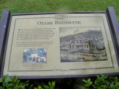
The mission style of the Ozark Bathhouse may relate to the claim that Spanish explorer Hernando de Soto visited the hot springs. The building’s twin towers are strictly decorative. On Bathhouse Row, the Quapaw, the Fordyce, and Hale Bathhouses, . . . — — Map (db m61794) HM
The Caddo, Quapaw, and Choctaw tribes lived in or visited the area during the 1700s and 1800s. This edifice pays homage to their lasting influence. The owners named the bathhouse for the Quapaw Indians, and incorporated an Indian head design over . . . — — Map (db m61795) HM
Compared to its elaborate neighbors, the Superior Bathhouse has a modest appearance. Its owners emphasized a therapeutic program and interior rooms where marble and brass fostered a hygienic environment. Known for “superior” service to patrons, it . . . — — Map (db m211033) HM
The Arlington Hotel, designed
for luxury accommodations,
opened April 1, 1875. The
wooden structure was three
stories tall with two huge wings
enclosing a large court. At the
time, the Arlington was the
largest hotel in Arkansas. — — Map (db m211144) HM
As you view the formal entrance to Hot Springs National Park today, several pieces of the original architectural design from the 1890s are no longer present. For example, a distinctive stone and wood pavilion called the Bandstand graced the top of . . . — — Map (db m145650) HM
1903/4 Built / Barnett Brothers Department Store (Jim, Charles & Ira Nelson); 1938 & 1978; Remodeled 1988; Sheid Furniture; Furniture Gallery; 2001 Pro Dentec main offices. (Renaissance Revival style; splayed stone . . . — — Map (db m221104) HM
Built in 1877 in the brick commercial
craftsman style with segmental arched
windows and pressed tin lintel caps,
this building originally housed the Boggs
Grocery Store. However, it was best remembered
as the home of the Menard Grocery, owned . . . — — Map (db m221115) HM
1908 built by S. A. Hail - single story dry
goods store; 1914 - second story
warehouse added; 1925 - third story
warehouse and brick front added;
1979 - Hail Dry Goods closed,
thereafter served as a hardware . . . — — Map (db m221113) HM
This site has been the location of three Independence
County courthouses. The first, built in 1857, was
destroyed by fire in the 1880's and replaced by a
Gothic style structure. Batesville's finest example of
Art Deco style building . . . — — Map (db m221135) HM
Originally constructed in 1875 as an opera house,
eight years later in 1883 it was converted to a
mercantile store. In 1939, then known as the
Brewer Store, it was purchased by Commonwealth
Theaters, remodeled in the Art Deco style and, . . . — — Map (db m221126) HM
This two story native sandstone building in the
vernacular commercial was given an Italianate flavor
by its arched windows. It was built in 1886 by H.L.
Miniken as an extension of his brother George
Miniken's general mercantile next door at 134 . . . — — Map (db m221130) HM
1872 built as Archer Mercantile on
ground floor and a saloon on the
second; 1888 altered to include present
arched windows (renamed Rutherford
Hall); housed a brothel, Ford Motor
dealership (Model T's stored on second
floor); . . . — — Map (db m221123) HM
1924 built by Victor Wade - print
shop/Batesville Record that became
Batesville Daily Guard;
late 1940's - Sears store (city's first);
variety of retail establishments follows.
Vernacular-panel brick, raised . . . — — Map (db m221132) HM
This property
has been placed on the
National Register
of Historic Places
by the United States
Department of the Interior
Williams Building
1887: Built/Richard Williams (formerly Evening Shade) Mercantile; 1898: Barnett . . . — — Map (db m221093) HM
This property
has been placed on the
National Register
of Historic Places
by the United States
Department of the Interior
B. D. Pennington House
circa 1888 — — Map (db m225357) HM
This bell was in use at the school at Lone Pine 1921-1953. The bricks in this monument were made on the site and used to build the Hagarville Academy in 1918. — — Map (db m225423) HM
The cabin before you is a good example of the kind of home built in early Powhatan.
A structure like this cabin, made of hand-hewn cypress logs, could be built
quickly with a few simple tools. Though its exact construction date is not
known, . . . — — Map (db m242579) HM
In early Powhatan, the kitchen was the center of life.
Just as we do today, the people who lived in Powhatan need a central place to store and prepare food.
While most people prepared their meals in the fireplace, wealthier families . . . — — Map (db m242583) HM
In 1815 Lawrence County was formed from the Territory of Missouri. It became part of the Arkansas Territory in 1819 when Missouri became a state. Thirty-one other counties were formed from Lawrence County, giving it the name, "Mother of Counties." . . . — — Map (db m155965) HM
This property has been placed on the National Register of Historic Places by the United States Department of the Interior Owners Joe Mason Sr Peggy Mason — — Map (db m238098) HM
This property has been placed on the National Register of Historic Places by the United States Department of the Interior Owner Elizabeth Pickens — — Map (db m238097) HM
This property has been placed on the National Register of Historic Places by the United States Department of the Interior Owner: Gene Yarbrough Family — — Map (db m238096) HM
The Lonoke Depot has been placed on the National Register of Historic Places by the United States Department of the Interior. Built in 1912, it was an important stop on Arkansas' oldest railroad, the Memphis to Little Rock line. The depot is a . . . — — Map (db m211575) HM
Kirkbride Potts, with help from his wife Pamelia Logan Potts, designed and constructed this large and stately building between 1850 and 1858. He patterned it after the Classical Revival style he knew in his home state of Pennsylvania; however, he . . . — — Map (db m120871) HM
This property
J. Madison White
has been placed on the
National Register of
Historic Places
by the United States
Department of the Interior — — Map (db m225429) HM
In 1854, Mr. J. L. Shinn established a business at this location in what was then called a cactus prairie. By 1870, other businesses had been established and residence had been built so the community was incorporated and was named Russellville, . . . — — Map (db m225435) HM
First Presbyterian Church
Des Arc, Arkansas
has been place on the
National Register
of Historic Places
by the United States
Department of the Interior — — Map (db m172139) HM
Near this spot stood the substantial brick home of Alexander George (1812-1877), a wealthy German immigrant active in Little Rock's business, civic, social and political circles. Built during the 1858 to 1859 period, the George House with its . . . — — Map (db m121455) HM
Ed and Hilda Cornish built this Tudor Revival style house in 1919. Theo Saunders was the architect.
Ed Cornish (1871-1928), a prominent banker, was president of the German Trust Company, and later president of the American Bank of Commerce and . . . — — Map (db m211500) HM
This property
First Missionary
Baptist Church
has been placed on the
National Register
of Historic Places
by the United States
Department of the Interior — — Map (db m211329) HM
This property
First United Methodist Church
Built in 1899
has been placed on the
National Register
of Historic Places
by the United States
Department of the Interior
1986 — — Map (db m211360) HM
[Left marker]
This property
has been placed
on the
National
Register of
Historic Places
by the United States
Department of the
Interior — — Map (db m211488) HM
This property
has been placed on the
National Register
of Historic Places
by the United States
Department of the Interior
Southern Trust Building
1907 — — Map (db m211324) HM
This property operated as horse stable in the late 19th century followed by the construction of single family dwellings. The primary user of the property during the 20th century was the Tuf-Nut Garment Manufacturing Company. Founded by James D. . . . — — Map (db m102093) HM
This property has been placed on the National Register of Historic Places by the United States Department of the Interior Arkansas Historic Preservation Program — — Map (db m229495) HM
This property
has been placed on the
National Register
of Historic Places
by the United States
Department of the Interior
The Second
Sarlo Cottage
1899 — — Map (db m211364) HM
Curran Hall, built in 1842, exemplifies the key elements of Greek Revival style: symmetrical form; horizontal emphasis of the rectangular form; classical elements of columns, pilasters, temple-like porch with pediment, transom and sidelights at the . . . — — Map (db m160932) HM
This property
Nash House
has been placed on the
National Register
of Historic Places
by the United States
Department of the Interior — — Map (db m211350) HM
This property
The Chisum House
has been placed on the
National Register
of Historic Places
by the United States
Department of the Interior
1894 — — Map (db m211463) HM
In 1904, John E. Geyer and his business partner John D. Adams moved their wholesale grocery business into a building located on this site. The partners replaced that building with this structure, designed by Charles Thompson, in 1914. The Geyer and . . . — — Map (db m102091) HM
Max Hilb and William Probst built this structure, designed by Joseph Willis, in 1882 for Probst & Hilb Liquor Company. The upper floor contained a two-story space that housed Concordia Hall, a Jewish social club. F. M. Fletcher and T.J. McCarthy . . . — — Map (db m102056) HM
This property has been
placed on the
National Register
of Historic Places
by the United States
Department of the Interior
Built in 1900 — — Map (db m211526) HM
deMun, a French aristocrat (Chevalier or Knight),
emigrated to the U.S. in the 1790s. A trained
draftsman, he became the right hand man of
Benjamin Latrobe, architect of the U.S. Capitol.
deMun oversaw the construction of the west wing . . . — — Map (db m170292) HM
The Old Randolph County Courthouse has been placed on the National Register of Historic Places By the United States Department of the Interior April 24, 1973. — — Map (db m172011) HM
Imagine spending 5 years building a home only to abandon it. That is exactly what the first Fort Smith soldiers did. They quarried rock and shaped logs to build the fort by hand. Shortly after completing it in 1824, they were reassigned to repeat . . . — — Map (db m156997) HM
In 1888, First National Bank built its first bank building, a modest two-story brick building at South Sixth and Garrison. A few years into the 20th century, bank president Samuel McLoud ordered plans drawn up for what would be the tallest building . . . — — Map (db m92366) HM
Before automobiles or airplanes, trains were the popular way to travel. At speeds of up to 65 mph (105 km), people traveled faster and farther than ever before. Besides visiting family and friends, trains took people to new and exotic places for . . . — — Map (db m156899) HM
The first Catholic church in Fort Smith was a log structure at North 3rd
and D Street. The Church of St. Patrick was dedicated March 5, 1848.
Bishop Andrew Byrne had purchased a square mile of land on the
outskirts of Fort Smith in 1847, upon . . . — — Map (db m236804) HM
Marble Hall, the oldest building on Garrison Avenue, was built in 1859 by Ethelbert Britton Bright. Judging from the surviving newspapers ads, his mercantile store held the very wonders of the world, steadily supplied by steamboats docking at the . . . — — Map (db m93241) HM
Ten years before the outbreak of the Civil War, the Old Red Mill stood on the future site of the New Theatre. The mill was used as a hospital during the Civil War, was damaged by the 1898 cyclone and finally disappeared around 1908. On the back . . . — — Map (db m92362) HM
From 1836 to 1878, the log cabin of Jeremiah and Sophia Kannady stood on the present-day 500 block of Garrison Avenue. In that cabin Kannady's uncle John Rogers, founder of the city, died in 1860. In 1877, Kannady sold land around his cabin to make . . . — — Map (db m93253) HM
In December 1878, Teddy Vogel and Michael C. Wallace bought the old rough hewn log store building and home that had been been constructed on this lot circa 1845 by Samuel Boothe. They razed the log structure and began building a stout, stone . . . — — Map (db m93246) HM
Stone fruit cellars, like this one, were once popular in the Ozarks. They were designed to keep food cool in the summer months and above freezing in the winter months.
Most were constructed in the 1920s and early 1930s as home canning was . . . — — Map (db m240312) HM
Zebulon “Zeb” Edmiston was the patriarch of one of Cane Hill's most prosperous Victorian era families. Zeb and Eunice Jane Gray were married in 1852 and had four children: Nina, James, David and John The Edmistons farmed in what is now Clark County, . . . — — Map (db m225063) HM
One of the first erected after Old Main,
Buchanan Hall was among the prettiest
buildings on campus while it stood. It
was built as a men's residential hall and
occupied by early 1888.
It was named for John L. Buchanan, the
sixth president of . . . — — Map (db m224278) HM
The Chi Omega was the first Greek organization to build its own chapter house on the University of Arkansas campus. Chi Omega (Psi chapter) purchased this lot in the Oakland Place Addition in 1928. Construction begin that that same year and the new . . . — — Map (db m224732) HM
[Top plaque]
Built A.D. 1930
Chi Omega
Greek Theatre
has been placed on the
National Register
of Historic Places
by the United States
Department
of the Interior
[Bottom plaque]
The Chi Omega fraternity . . . — — Map (db m224254) HM
Civil War in Northern Arkansas
The first battle in Arkansas occurred on February 16, 1862, at Big Sugar Creek just south of the Missouri border. The next day, Union Gen. Samuel Curtis' Army of the Southwest continued its southward march. . . . — — Map (db m224112) HM
Gray Hall was built as a men's residence hall in 1906 at the same time as Carnall Hall. It was named for Oliver C. Gray and stood near what later became the west entrance to Mullins Library. Its basement was used as dressing rooms for the football . . . — — Map (db m224276) HM