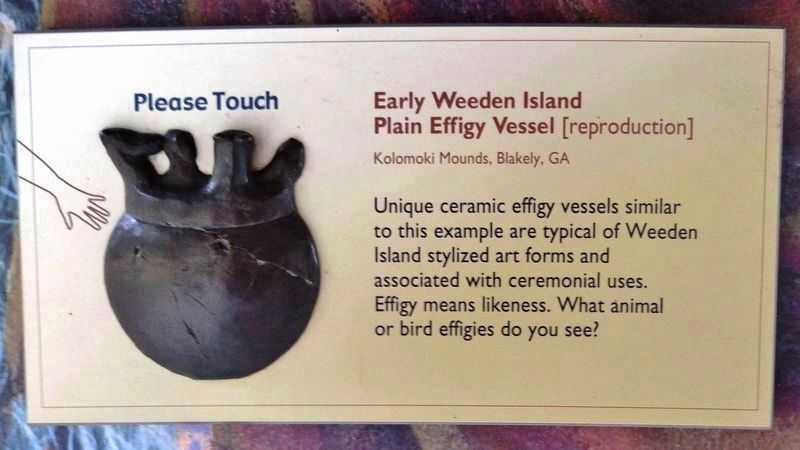
If you were able to travel back in time over 1,100 years to the peak period of the Weeden Island civilization, you would witness the construction of one of the greatest feats of American Indian architecture in the region now known as Florida. You . . . — — Map (db m153298) HM
After the 1850s, Dunlawton's days as a serious sugar venture were through. John Marshall moved away, tried to rid himself of the Florida plantation, and finally snared a buyer in 1871. His successors included Charles Dougherty (a noted . . . — — Map (db m46551) HM
The ruins here include chimneys and other structures made of coquina, Spanish for "tiny shell." Quarried locally (and elsewhere in the Southeast), this native stone contains mollusk shell fragments and quartz sand, bound together by . . . — — Map (db m46539) HM
Welcome to DeBary Hall Historic Site - once the winter retreat of a wealthy New York wine merchant. European-born Frederick deBary (who used a small d while others capitalized) built this house in the 1870s, acquired thousands of acres, . . . — — Map (db m175936) HM
One reality of this sugar plantation was its isolation. When owner John Marshall asked for help against the Seminoles, an army commander in St. Augustine offered muskets and a lecture: "I need scarcely add," he warned, "that the best reliance of the . . . — — Map (db m46550) HM
How do we know what we know about Dunlawton? The information sources range from period documents to objects in the ground. Questions remain, but researchers have made a start at uncovering the plantation's key stories. Among the written sources, . . . — — Map (db m46549) HM
When Sarah Anderson and her sons owned Dunlawton, Mosquito County settlers formed a militia unit called the Mosquito Roarers. Even with its fine name, this group reportedly lacked anyone who had ever "seen a gun fired in anger." By the mid-1830's, . . . — — Map (db m46547) HM
Dunlawton's new metal roof is meant to protect stonework and machinery. But it also makes an important point. Though not an exact replica of the wooden roof that protected it, this shelter reminds us that a large, enclosed factory once stood here. . . . — — Map (db m46544) HM
The Dunlawton Plantation was no leisure spot. As a frontier agricultural and processing site, it demanded hard, physical, un-glamorous work. Without the labor of African-American slaves and hired free workers, this nineteenth-century venture would . . . — — Map (db m46545) HM
Hotel Ormond, named for Volusia County pioneer James Ormond, was built in 1887 by John Anderson and Joseph Price. The large frame building was bought and enlarged by Henry M. Flagler in the 1890's. Operated by Flagler's Florida East Coast Railway, . . . — — Map (db m34552) HM
These are the ruins of people's dreams, left by successive landowners, free workers, and slaves. Hoping to make sugar in the nineteenth century, they faced isolation, hurricanes, and dispossessed Seminoles. Some lost money in their ventures, and . . . — — Map (db m46537) HM
Welcome to Dunlawton's boardwalk - a modern structure offering views of the former sugar factory while reducing foot traffic inside. (More on the nineteenth-century floorplan can be found in an interpretive panel near the ruins' south side.) Today's . . . — — Map (db m46543) HM
In the early nineteenth century, many of this region's large agricultural ventures focused on sugar - coarse, brown, and valuable. To get the most from their sugar cane, some planters had their own crushing and cooking operations. At plantations . . . — — Map (db m46541) HM
When Daytona Beach was founded in 1876 two of its founders, John Tolliver and Thaddeus S. Gooden, were African American. Over the years, Jim Crow laws changed the state drastically, and by the 1920s, African Americans were banned from most of . . . — — Map (db m136030) HM
As the U.S. government expanded to new territories and established reservation lands, conflicts ensued between the U.S. government and the native peoples of North America. Reservation lands currently total 55.7 million acres in the continental . . . — — Map (db m154860) WM
Bosnian War
1993 - 1995
The U.S. joined NATO in this international conflict, which ended an ongoing three-year civil war, and resulted in the Dayton Agreement.
Total Active Serving Unknown
Killed In Action Unknown
Wounded In . . . — — Map (db m154963) WM
Sparked by global Cold War tension, United Nations forces, led primarily by the United States, intervened to support South Korea. After an almost two-year stalemate, where battles raged but no land was gained, a protracted armistice negotiation . . . — — Map (db m154874) WM
U.S. forces joined a multi-state coalition to bring an end to the Libyan civil war, ultimately leading to the fall of the Gaddafi regime.
Total Active Serving Unknown
Killed In Action Unknown
Wounded in Action Unknown — — Map (db m154983) WM
On October 7, 2001, U.S. and coalition forces invaded Afghanistan in response to the 9/11 attacks and began combat action against Al Qaeda terrorists and Taliban supporters. After 13 years of combat, the operation was officially concluded on . . . — — Map (db m154966) WM
The United States led a coalition of forces to disarm Iraq and establish a democratic Iraqi government. Coalition forces also helped to secure the new government, and combat the insurgency that followed. The majority of U.S. ground troops . . . — — Map (db m154975) WM
Operation Just Cause
1989
The United States invasion of Panama led to the capture of Dictator Manuel Noriega, and the restoration of a democratic government.
Total Active Serving 27,684
Killed In Action 23
Wounded In Action 324 . . . — — Map (db m154953) WM
Operation Urgent Fury
1983
The U.S. led invasion of Grenada resulted in the overthrow of the revolutionary forces in power, and the restoration of a constitutional government.
Total Active Serving 7,300
Killed In Action 19 . . . — — Map (db m154928) WM
After the invasion of Kuwait by Iraq, U.S. and coalition military forces were deployed to liberate Kuwait and protect Saudi Arabia. Allied forces acted swiftly, driving the Iraqi forces out of Kuwait within 100 hours. Combat operations ended on . . . — — Map (db m154952) WM
Following a series of aggressions by North Vietnam, including attacks on U.S. forces in the Gulf of Tonkin, the U.S. Congress authorized the deployment of U.S. forces for warfare against North Vietnam. Beginning in 1964, U.S. forces gradually . . . — — Map (db m154921) WM
After communist losses during the Tet Offensive and increasing political pressures at home, in 1969, the U.S. began a gradual withdrawal of ground forces, with U.S. military involvement ending in the spring of 1975.
The war ended after the . . . — — Map (db m154925) WM
On December 8, 1941, the United States declared war against Japan in response to the bombing of Pearl Harbor. Days later, Germany formally declared war against the United States, starting a global war which ultimately claimed between 50-85 . . . — — Map (db m154861) WM
European Theatre
Beginning with Germany’s invasion of Poland, by June of 1940, Germany had taken control of a large portion of Western Europe, and was moving to invade the United Kingdom. Allied forces, led by the U.S. and British forces, . . . — — Map (db m154863) WM
Pacific Theatre
After three years of fighting over a vast area of the southwest Pacific, the war against Japan culminated in the atomic bombings at Hiroshima and Nagasaki. The Japanese unconditional surrender formally took place aboard the . . . — — Map (db m154872) WM
In 1899 the Tasker family purchased this block and built a house on the southwest corner. Phoebe A. Verrill bought the house in 1909 and sold it to the Cason family in 1921. The Casons converted the house into apartments and c.1924 built a second . . . — — Map (db m96763) HM
The raft to your left washed ashore in Volusia County in 1989. Clothing found onboard suggests that children were among those on the raft. The orange life vest was left behind by the Coast Guard to indicate that these refugees were rescued at sea. . . . — — Map (db m114262) HM
The jewel of this park is its spring, a popular attraction for tourists and travel writers over the years. Green Springs (also known in the past as Green Sulphur Spring and Green Spring, without an s) struck people as exotic and strange. A guidebook . . . — — Map (db m265522) HM
Welcome to Green Springs Park-a 36-acre public area with a remarkable past, a famous sulphur spring, and recreational features including a playground and trails. Volusia County hopes that your visit will be as special as the resource itself. . . . — — Map (db m265504) HM
Green Springs had many owners after Cornelius Taylor first claimed these lands in 1842. Certainly the most exotic were the deBarys — NewYork wine merchants who wintered near Enterprise starting in the 1870s. European-born Frederick deBary and his . . . — — Map (db m265518) HM
Though it no longer exists for visitors to see, a prominent landmark once stood on the lakeshore southeast of
here. The Enterprise midden was a refuse heap for people occupying
these spring lands thousands of years ago. Its mass of freshwater . . . — — Map (db m265525) HM
Some watercourses in Green Springs Park are former orange grove ditches. But below this overlook flows a natural creek draining both the ditches and receiving water from the area's springs. One named spring has vanished since hotel guests . . . — — Map (db m265524) HM
After the Civil War, as people eagerly explored America, Florida saw a travel boom that continued for decades. One guidebook writer in 1885 called tiny Enterprise "the Mecca of tourists." Well into the 1920s, visitors bound for Lake Monroe could . . . — — Map (db m265509) HM
This Volusia County beach access is named for a part-time Ormond resident known as “the richest man in the world.” Through his Standard Oil empire, John D. Rockefeller controlled U.S. refining in the late nineteenth century. One . . . — — Map (db m153411) HM
Born in Potsdam, New York on May 2, 1824, French served as a Surgeon with the 21st and 35th New York Regiments, New York Volunteers during the early years of the Civil War. In 1863 he moved to Eau Clair, Wisconsin but susceptibility to rheumatism . . . — — Map (db m52228) HM
People have lived near the spring for over 6,000 years! Since the late 1800s, the spring has attracted visitors from all over the world. Until 1982, De Leon Springs was privately owned. In 1980 the owner, George Thofehrn, wanted to sell the . . . — — Map (db m261983) HM
Founded soon after the U.S. Civil War, the settlement that would become “Freemanville” was established by Dr. John Milton Hawks, an abolitionist and Union Army surgeon, along with other Union Army officers and the Florida Land & Lumber . . . — — Map (db m45453) HM
This corner was the site of DeLand's first newspaper, The Volusia County Herald, first published on May 10, 1877 by Henry DeLand. It was succeeded in 1878 by The Agriculturalist, edited by Col. C. C. Codrington, Gov. General of the . . . — — Map (db m45727) HM
(side 1)
African American families living in DeLeon Springs in the 1920s needed a better school. The Mt. Zion African Methodist Episcopal Church was no longer adequate and classes moved to St. Joseph Lodge, but it also was too small. In . . . — — Map (db m101681) HM
During the Second Seminole War (1835-1842), troops under the command of Brig. Gen. Abraham Eustis left Volusia County headed toward the Withlacoochee River as part of a military action in response to the December 28, 1835 massacre of Major Francis . . . — — Map (db m56224) HM
The Lake Monroe Bridge was the first electrically operated swing bridge in Florida. In 1932-33 the State used federal assistance to build this bridge, which replaced a wooden toll bridge that was manually operated. The construction of the bridge . . . — — Map (db m45490) HM
On February 9, 1960, students from DeLand's all-Black Euclid High School staged a sit in at the lunch counter at the DeLand Woolworth's store, which occupied this building. One of the leaders that day was Dr. Joyce M. Cummings Cusack, who went on to . . . — — Map (db m268282) HM
On February 9, 1960, students from DeLand's all-Black Eucilid High School staged a sit in at the lunch counter at the DeLand Woolworth's store, which occupied this building. One of the leaders that day was Dr. Joyce M. Cummings Cusack, who went . . . — — Map (db m268275) HM
This terra cotta wall is all that remains of what was to be a grandiose hotel and resort. It was started during the great land boom of the 1920's. The developer, Robert (Bob) Pacetti was a native of this area. His ancestors first came to this . . . — — Map (db m52457) HM
(Side 1)
Greetings from Daytona Beach
Home of Daytona International Speedway
(Side 2)
America250FL Road Trip
Volusia County roars at Daytona International Speedway, a global motorsports icon. Tour this . . . — — Map (db m311320) HM
The monument near this panel honors young men who served in a conflict hardly known by modern Americans. Yet in 1917 and 1918, the U.S. joined in a war that touched many Florida families, including people in rural Osteen. From Volusia County, nearly . . . — — Map (db m150967) HM
The year was 1946, Daytona Beach was the only city in racially segregated Florida, perhaps in the entire South, that accepted integrated professional baseball. City officials ignored Jim Crow laws when the Brooklyn Dodgers and their top minor . . . — — Map (db m213921) HM
On March 16. 1864 Acting Ensign Sanborn, commanding the USS Columbine of the Union fleet, which was patrolling the St. Johns River into Lake Monroe, landed at Enterprise and sent Mr. Davis and a squad of men from the 48th New York infantry to . . . — — Map (db m127266) HM
The Orange City Colored School was the first building in town constructed for education of African Americans. Before it opened in 1927, various buildings had been adapted for use as classrooms but were small and poorly lighted. Inspired by her . . . — — Map (db m101682) HM
Welcome to Volusia County's Mary McLeod Bethune Beach Park—once part of a nationally known African-American resort. Named for a noted educator and presidential advisor, this spot gave black people a place of their own when most Florida beaches . . . — — Map (db m131762) HM
On May 9, 1931, the land beyond this sign was donated to the Betsy Ross Air Corps, a pre-World War II organization of female pilots. Designated the Betsy Ross Airport, the airfield was the only airport in the nation entirely owned and operated by . . . — — Map (db m251266) HM
In 1888, Henry A. DeLand donated land for the construction of a wooden courthouse after the city of DeLand became the new seat for Volusia County. Starting in 1927, construction began on a new courthouse designed in the Neoclassical style. Competed . . . — — Map (db m136023) HM
In 1888, Henry A. DeLand donated land for the construction of a wooden courthouse after the city of DeLand became the new seat for Volusia County. Starting in 1927, construction began on a new courthouse designed in the Neoclassical style. Competed . . . — — Map (db m136024) HM
In the early 1920s, F. N. Conrad purchased the spring and some of the surrounding property. His plan was to "preserve and enhance the natural beauty of this historical place." With a design from a landscape architect, Conrad constructed the Ponce . . . — — Map (db m195497) HM
In 1843 Enterprise became county seat of Mosquito County, organized December 29, 1824, and changed to Orange County in 1845. On Dec. 29, 1854 the part of Orange County east of the St. John's River became Volusia County with Enterprise as County . . . — — Map (db m276893) HM
The convict cage wagon was used to transport prisoners who were leased to corporations for road work, timber harvesting and turpentining They were often chained together, as in this photo. The leasing program was abolished in Florida in 1923, . . . — — Map (db m135545) HM
The process for sugarcane syrup production on farms in Florida has not changed that much for well over 100 years. It takes the cane a year to reach maturity and its peek sweetness along with a light frost in the fall generally in November to early . . . — — Map (db m135548) HM
The log cabin is the only building at the settlement that is not original to Florida. Jim Lewis of Georgia built it in 1876. In 1992 his descendants purchased the cabin and sponsored it’s transportation and reconstruction. It is an excellent . . . — — Map (db m135521) HM
Named Midway because Barberville was half way between Jacksonville and Tampa on the Methodist Minister’s circuit. The church was built in 1890. It served the community until 1964 and was donated to the Pioneer Settlement by the DeLand District of . . . — — Map (db m135539) HM
Built in the 1920's, the house was moved from New Smyrna Beach in 1997. The shotgun style is indicative of the homes built to quarter workers in the Naval Stores Industry (turpentine). The structures were cheaply built and occupants frequently . . . — — Map (db m135594) HM
Originally the Guenther
Blacksmith Shop in DeLand, it
was built in around 1900.
The building served as the
Settlement’s smithy until 1987
when it was re-purposed
to serve as the Firehouse.
It contains fire-fighting . . . — — Map (db m135443) HM
During the post Civil Was era, numerous Swedish people came from northern states and directly from Sweden to settle and help develop the still largely wilderness area of central Florida.
In 1868, John A. Bostrom, a native of Sweden’s Island . . . — — Map (db m135590) HM
The center of the turpentine camps, the still was used to process pine resin into turpentine and rosin. This still is the only known still open to the public in Florida. The Tomoka Land Company near Daytona Beach built the still in 1924. It was . . . — — Map (db m135501) HM
The roadside tourist attraction industry started in the 1930's after the Great Depression. During this time, automobiles replaced trains as the main mode of transportation. After World War II, millions of visitors began making Florida their annual . . . — — Map (db m188500) HM
William Bartram's Travels Famed naturalist, artist and poetic writer William Bartram first visited Blue Spring in January 1766. His writing and artwork inspired many, from naturalist artist John James Audubon to Romantic poet Samuel . . . — — Map (db m184662) HM
The pioneer families of this cemetery put down roots on the Florida frontier—a place considered "desolate" at the time. In the 1850s, George and Adeline Sauls settled two miles west of here on a stage road. They constructed a large log home . . . — — Map (db m93337) HM
Huntington was a small community located west of
Crescent City and east of Lake George. After the
railroad came through the area in 1885, the post office
was built to accept mail for the community.
It was donated and moved to . . . — — Map (db m135491) HM
Sites Bartram Visited in Volusia County These sites are locations visited by John and William Bartram along the St. Johns River and included in William's book, Travels. A site listed below with a blue heading is accessible by . . . — — Map (db m184721) HM
Volusia County
Navy “Dive Bomber” pilots
who trained in Volusia County
were part of efforts on two fronts
to bring WW II to a close in 1945.
At any given time from 1942 - 1946,
nearly 3,000 officers and enlisted men . . . — — Map (db m210629) WM
In 1905 the Landis & Fish Law Firm erected a brick one-story Romanesque-style building on this site. As the firm grew, it was enlarged in 1925 to the two-story Federal structure you see today. Begun by Cary D. Landis and Bert Fish, the firm was . . . — — Map (db m46032) HM
Thin black lines indicate changes in relevance. Between each pair of lines entries are ordered geographically but all have the same relevance.
* Inflectional forms of words are their plurals, singulars, and possessives as well as gramatical tenses and similar variations.