By William Fischer, Jr., February 18, 2012
Discovering the Colorful History of Columbus Marker and Mural
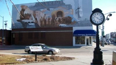
| On 13th Street (Business U.S. 30) at 26th Avenue, on the left when traveling east on 13th Street. |
| On 33rd Avenue (U.S. 30/81) at 7th Street on 33rd Avenue. |
| On 33rd Avenue (U.S. 30/81) at 7th Street, on the right when traveling south on 33rd Avenue. |
| On U.S. 34, 0.1 miles west of 7th Street, on the right when traveling west. |
| On West Lane in Bellevue Cemetery., on the right when traveling north. |
| On 10th Street north of Laplatte Road, on the left when traveling north. |
| On the Westbound Rest Stop (Interstate 80 at milepost 431), on the right when traveling west. |
| Near Old Oregon Trail Road (County Road K) 3 miles west of Meadowlark Boulevard, on the right when traveling west. |
| Near Old Oregon Trail (Old State Highway 92) 1.8 miles west of Five Rocks Road, on the right when traveling west. |
| Near Old Oregon Trail Road (State Highway 92). |
| On Robidooux Road, on the left when traveling west. |
| Near Old Oregon Trail (County Road K) 3 miles west of Meadowlark Boulevard, on the right when traveling west. |
| On U.S. 26 near County Route 4, on the left when traveling west. |
| Near Interstate 80 at milepost 381,, 2 miles east of Exit 379 (State Highway 15), on the right when traveling east. |
| On Mari Sandoz Sandhills Trail (State Highway 27) 24 miles north of State Highway 2, on the right when traveling north. |
| On 190th Lane, 0.5 miles north of Bridges to Buttes Byway (U.S. 20), on the left when traveling north. |
| On South Post Street just south of Bridges to Buttes Byway (U.S. 20), on the right when traveling south. |
| On River Road at State Highway 29, on the left when traveling east on River Road. |
| On River Road at State Highway 29, on the left when traveling east on River Road. |
| On River Road, 3.2 miles State Highway 29, on the right when traveling east. |
| On River Road at State Highway 29, on the left when traveling east on River Road. |
| On U.S. 20 at milepost 30 east of Vogl Road, on the left when traveling east. |
| Near Montrose Road at Hat Creek Road, on the left when traveling east. |
| On State Highway 29, 0.4 miles south of Evergreen Road, on the right when traveling south. Reported missing. |
| Near Montrose Road at Hat Creek Road, on the left when traveling east. |
| On U.S. 75, 0.1 miles south of West Main Road, on the left when traveling south. |
| On U.S. 77, 0.2 miles north of North Main Street (State Highway 94), on the left when traveling north. |
| On Matthewson Street just east of Sawyer Street, on the left when traveling east. |
| On U.S. 75/77, 0.2 miles north of Saint Augustine Drive/C Avenue, on the left when traveling north. |
| Near Madison St, 0.8 miles east of U.S. 75. |
| Near Madison St, 0.6 miles east of U.S. 75. |
133 entries matched your criteria. Entries 101 through 133 are listed above.
⊲ Previous 100