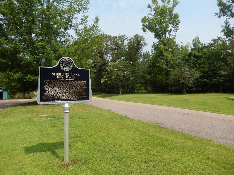
Near Braggs Road (Alabama Route 263) 0.4 miles north of Sherling Lake Road (County Road 44), on the left when traveling north.
Commissioned and opened to the public in 1950, Sherling Lake is part of the Alabama Department of Conservation's efforts to construct public fishing lakes throughout Alabama in the 1940s. Greenville Chamber of Commerce President A.G. Johnson . . . — — Map (db m228690) HM
On Woodstock Avenue at East 14th Street, on the right when traveling north on Woodstock Avenue.
This sign marks the start line of the
Woodstock 5K, one of the oldest continuous
footraces in the southeast. First held in
1980, the race takes place the first Saturday
in August each year and rollercoasters
through the historic neighborhoods . . . — — Map (db m217680) HM
On East 10th Street at Quintard Avenue, on the right when traveling west on East 10th Street.
In 1904, 18 year old Tyrus Raymond Cobb lived in a boarding house on this site while playing minor league baseball for the Anniston Steelers. From nearby Scarbrough Drug Store on Noble Street he wrote letters, using fictitious names, to sports . . . — — Map (db m106606) HM
The ancestral traditions of the Muscogee (Creek) Nation are still practiced
today. Among these is a game called “Little Brother of War" or "stickball”.
The game is used to settle disagreements, to toughen warriors and
sometimes for . . . — — Map (db m144938) HM
On Lafayette Street North (U.S. 431) at 1st Avenue Southwest, on the right when traveling north on Lafayette Street North.
World Heavyweight Champion
1937-1949
Born May 13,1914
Chamber County, Alabama
Died April 12,1981
Buried Arlington National Cemetery
Arlington, Virginia
"The Brown Bomber"
"Joe Louis is a credit to his Race… The . . . — — Map (db m197976)
On County Route 15 south of County Route 830, on the right when traveling south.
Born in Lockhart, Alabama in 1915, Tarzan played alongside Bear Bryant on the University of Alabama's 1934 National Championship Team and was honored as an All-American in 1936. He went on to play for the New York Giants, winning a NFL Championship . . . — — Map (db m115273) HM
On Bashi Road (County Road 48) 5 miles west of Route 25, on the right when traveling west.
Established by Choctaw and Creek Indians about 1808 as the northern limit of boundary line between their lands. This line begins at the cut-off in South Clarke County, follows the watershed between Alabama and Tombigbee Rivers without crossing . . . — — Map (db m83271) HM
On Court Square at 1st Street North, on the right when traveling west on Court Square.
Side 1
Clay County was formed by an act of the Alabama General Assembly on December 7, 1866. Less than a year later, Ashland was established as the county seat on land donated by Hollingsworth Watts for the construction of a . . . — — Map (db m95087) HM
On East 3rd Street east of N East Street, on the right when traveling west.
Heinie was born at the family home, 1005 East Third Street, Tuscumbia, Alabama to George and Catherine Manush, the youngest of eight children. Five of the seven brothers were involved in organized baseball, with two going to the Major Leagues. His . . . — — Map (db m312406) HM
Erected and dedicated to the
memory of those of Dallas
County who fought and died in
two world wars that we may
retain our great heritage of
freedom, justice and democracy
World War I
April 6, 1917–November 11, 1918 . . . — — Map (db m82029) WM
On Alabama Route 75 0.1 miles east of Main Street ( Route 227), on the right when traveling north.
(front)
No one knows for sure how Geraldine got its name. Some say it was named for a lovely Indian maiden. The first official record was on September 5, 1882 when Mr. William A. Johnson applied for the location of a new post office. The . . . — — Map (db m79905) HM
On Martin Luther King Avenue north of McGlasker Street, on the right when traveling north.
In 1920, a wooden building was constructed as the Atmore Colored School and operated until 1925. In 1926, a new wood and a brick building was erected with assistance from Rosenwald School fund and it was renamed the Escambia County Training School. . . . — — Map (db m100835) HM
Near Mound State Parkway 1.5 miles west of Route 69.
Imagine a clan chief 800 years
ago standing exactly where
you are. It's possible he would
see something resembling this
artist's rendering. Larger
mounds, like this one, dotted
the plaza's perimeter, serving
as elevated platforms for . . . — — Map (db m144752) HM
On South St Andrews Street, on the right when traveling south.
Johnny Mack Brown, an outstanding athlete and western movie star, was born in Dothan on September 1, 1904. Johnny Mack was one of nine children born to John Henry and Hattie McGillivray Brown. The Brown family home was located on South Saint Andrews . . . — — Map (db m83783) HM
On Clairmont Avenue South at 32nd Street South., on the right when traveling west on Clairmont Avenue South.
The first Alabama - Auburn football game was played on this site, formerly known as the Base Ball Park, on February 22, 1893. The Agricultural and Mechanical College's "Orange and Blue" met the University of Alabama's "Tuskaloosa" squad before a . . . — — Map (db m23500) HM
On Cahaba Road at Park Lane, on the right when traveling north on Cahaba Road.
In 1822 William Pullen, Revolutionary War veteran, acquired this land from the Federal Government for farming. In 1889 his heirs sold the land to the City of Birmingham for use as the New Southside Cemetery which operated from 1889 to 1909 with . . . — — Map (db m27096) HM
On 12th Street West at 2nd Avenue West on 12th Street West.
Built by local industrialist A. H. "Rick" Woodward, this park opened on August 18, 1910. It is the oldest surviving baseball park in America. Rickwood served as the home park for both the Birmingham Barons (until 1987) and the Birmingham Black . . . — — Map (db m22526) HM
On 12th Street Southwest at 1st Court West, on the right when traveling north on 12th Street Southwest.
Built by Birmingham industrialist A. H. “Rick” Woodward, Rickwood Field served as home to the Birmingham Barons and Birmingham Black Barons for most of the 20th century. Recognized as “America’s Oldest Baseball Park,” . . . — — Map (db m83837) HM
On Roebuck Boulevard, on the left when traveling east.
In 1850 George James Roebuck and his wife Ann Hawkins Roebuck built a log cabin at the mouth of Roebuck Spring. His Influence and leadership led to the area around it to be known as Roebuck. In 1900 Alabama Boys Industrial School was located . . . — — Map (db m26688) HM
On Cumberland Drive east of 4th Avenue South, on the right when traveling east.
Roebuck Springs was the first large residential suburb in Birmingham where planning and development were tied to the automobile, and the first community in the city associated with a golf course development. The 1910 land plan was designed to . . . — — Map (db m26684) HM
On Main Street at Walnut Street, on the right when traveling south on Main Street.
The town of Cardiff, Alabama has a long, rich history. Situated
along the winding picturesque banks of Five Mile Creek, the area
of present-day Cardiff was originally settled in the 1830s by the
Crocker family. According to historian Martha . . . — — Map (db m153234) HM
On Lakeshore Drive at University Park East, on the right when traveling east on Lakeshore Drive.
The developers of the Town of Edgewood, Stephen Smith and Troupe Brazelton, built the beautiful 117.4 acre lake and clubhouse in 1913-15. Amenities included a swimming pool, dance pavilion, fishing, boating and parking for hundreds of automobiles. . . . — — Map (db m26963) HM
On Hueytown Road at High School Road, in the median on Hueytown Road.
During the early 1800s, members of the Huey family took pioneering steps toward establishing the community that would eventually become the City of Hueytown. On May 6, 1960. Hueytown
was officially incorporated under a Mayor/Council form of . . . — — Map (db m212934) HM
Plans for the Florence Little League Baseball program for youth in ages ranging from eight to twelve years were completed in April 1951. These plans and the layout of this playing field were in accord with those developed by America's first Little . . . — — Map (db m83969) HM
Near Hightower Place just south of Veterans Drive ( Route 133), on the left when traveling south.
The NFL Rookie of the Year (1954) and MVP (1955), Harlon Hill starred with the Chicago Bears. The Harlon Hill Trophy is presented annually to the NCAA Division II Football Player of the Year. — — Map (db m219314) HM
Near Hightower Place near Veterans Drive ( Route 133), on the left when traveling south.
Often referred to as the most successful breeder of thoroughbred horses in America, James Jackson imported Glencoe and Leviathan to the U.S. in the early 1800's, leaving a permanent imprint on both the breed and American racing history. — — Map (db m219334) HM
Serving as head coach in women's collegiate
basketball, 1970-1996, Lin Dunn became a
17-year coach in the Women's National
Basketball Association (WNBA) and was
inducted into the WNBA Hall of Fame in 2014.
Inducted 2018
City of . . . — — Map (db m219309) HM
Near Hightower Place south of Veterans Drive ( Route 133), on the left when traveling south.
Winner of both national and international golfing championships, in 2009 Stewart Clink became the first native Alabamian to claim the coveted claret jug as the champion of the British Open in Turnberry, Scotland. — — Map (db m219306) HM
The University of North Alabama became the first school in the history of NCAA scholarship football to win three consecutive national championships (1993, 1994, and 1995). Under Coach Bobby Wallace, UNA posted a 41~1 record over the same three ~ . . . — — Map (db m32765) HM
As the Head Coach for the football team at the University of North Alabama, Robert Hue ("Bobby") Wallace's team earned three consecutive Division II National Championships (1993-1995),
and he was named Division II Coach of the Year three . . . — — Map (db m219300) HM
A beloved high school teacher and athletics coach, William "Bill" Yoast was a leader in the successful integration of a racially diverse football team in Virginia in 1971. It became the inspiration for the highly acclaimed film, "Remember the . . . — — Map (db m268958) HM
On April 20, 1934, a temporary charter was issued for Gen. Joe Wheeler Post 58, Courtland, Alabama.
On November 12, 1946, a permanent charter was granted and the name changed to Wiley Horton Post 58 in honor of the deceased son of State . . . — — Map (db m84303) HM
Born near this site 12 September 1913 to Henry Cleveland and Emma (Fitzgerald) Owens, who were sharecroppers and the offspring of freed slaves, Jesse was destined to attain immortality in the 1936 Olympic Games at Berlin, Germany. Although he moved . . . — — Map (db m80969) HM
Jesse Owens track career started in high school when one day in gym class, the students were timed in the 60-yard dash. Coach Charlie Riley saw the raw, yet natural talent that young Jesse had and immediately invited him to run for the track team. . . . — — Map (db m80943) HM
On Alabama Route 203 south of Route 187, on the right when traveling north.
He inspired a world enslaved in tyranny
and brought hope to his fellow man...
from the cottonfields of Oakville to the
acclaim of the entire world. He made us
all proud to be called Lawrence Countians.
Dedicated October, 1983 . . . — — Map (db m180484) HM
On County Route 59 at County Route 7, on the right when traveling west on County Route 59.
Youngtown was earlier known as Egypt. The community's name changed after 1915 to recognize the Young family. By 1857, Reason Young owned land and slaves in this area. Newspapers in 1891 speak of Joseph Young and in 1915 of Arthur Young living "in . . . — — Map (db m274336) HM
Near War Eagle Way at South Donahue Street, on the left when traveling west.
(Side 1)
Max Adams Morris
Max Adams Morris b. December 7, 1918, of Blountsville, Alabama, entered Alabama Polytechnic Institute (API) in 1938, was a varsity football player and became a member of "A" club, Scabbard & Blade, and . . . — — Map (db m85166) HM
Near Oakwood Avenue Northeast just east of England Street Northeast, on the right when traveling east.
Dallas (Optimist) Park
1928-1949
Built in 1928, Dallas Park served as the baseball field for the Dallas Mill teams coached by H.E. "Hub” Myhand, who came to Huntsville in 1927 as physical director for Dallas Manufacturing Co. Until the . . . — — Map (db m154279) HM
On Ward Avenue NE at White Street NE, on the left when traveling east on Ward Avenue NE.
On January 25, 1934, Oscar Goldsmith, Lawrence B. Goldsmith, Annie Schiffman Goldsmith, Robert L. Schiffman, and Strauss Schiffman gave this property to the City of Huntsville for an athletic field. The gift was in memory of Betty Bernstein . . . — — Map (db m130148) HM
Near North Bainbridge Street north of Dexter Avenue, on the right when traveling south.
Made in Alabama
Alabama has contributed to the nation's arts and
entertainment life since statehood. In the mid-twentieth
century, it shaped American culture in profound ways.
In a career launched from Montgomery radio and . . . — — Map (db m182641) HM
On South Union Street, on the left when traveling north.
Swayne CollegeNamed for Union General and Freemen’s Bureau Agent Wager Swayne, Swayne College was dedicated 21 April 1869. The Bureau appropriated $10,000 for the building and the local black community purchased 3.5 acres for the site. Future . . . — — Map (db m28171) HM
On State Road 36 0.1 miles east of Johnson Chapel Road, on the left when traveling east. Reported permanently removed.
1936 Olympic Silver Medalist
Morgan County native David Donald Albritton competed at the XI Olympics in Berlin, Germany and became the first Alabama native to win an Olympic track and field medal. During Olympic Trials on July 11, 1936 at . . . — — Map (db m160716) HM
On Alabama 36 (Alabama Route 36) 0.1 miles east of N Johnson Chapel Road, on the left when traveling east.
Morgan County native David Donald Albritton competed at the XI
Olympics in Berlin, Germany and became the first Alabama native
to win an Olympic track and field medal. During Olympic Trials
on July 11, 1936 at Randall's Island in New York City. . . . — — Map (db m299715) HM
On Clara Avenue Southwest north of Clearview St SW, on the right when traveling north.
The pride of its community, Austinville High School opened at this
site in 1937, on land donated by A. J. Roper. It continued as a high
school for students in the surrounding countryside for more than two
decades. In 1959, after the Austinville . . . — — Map (db m299719) HM
On 12th Avenue Northwest at 6th St NW, on the right when traveling south on 12th Avenue Northwest.
This park is dedicated to the players, coaches and families who made the Rough Riders
football team unique and special part of Decatur's history.
The Rough Riders were a semi-professional football team from Decatur, Alabama. The team was . . . — — Map (db m285758) HM
On Oak Street Northeast at Line St, NE on Oak Street Northeast.
Named in honor of
W. W. “Barney” Benson, Supt. Ed. 1927 - 38
H. L. “Shorty” Ogle, Coach 1934 - 64
Aubrey Fuller, Asst. Coach 1929 - 58
The “T” formation was introduced to Alabama here in 1941
On . . . — — Map (db m28268) HM
Guarding the Flame of the Centennial Olympic Games
These heroes carried the sacred flame the
symbol of World Peace, Friendship and Unity.
Lane Barnes, William Debuty,
Charles Friedrich, Jeremy Gaertner,
Kevin Hall, Jordan Hardick,
Katie . . . — — Map (db m106095) HM
On Union Hill Road at Apple Grove Road, on the right when traveling east on Union Hill Road.
Home of Morgan County's First State
Basketball Champions, 1950
This team won
County, District and State Championships
compiling a season record of 38-1
Team Members
James “Bobo” Bowling, Mel Bowling,
Melvin Compton, . . . — — Map (db m160646) HM
On University Avenue west of South George Wallace Drive, on the left when traveling west.
“Tailgating" on the Troy campus was initiated during the 1990’s through the example and leadership of Green Davis. In 1993 the area outside of Memorial Stadium was named in honor of Green Davis for his enduring efforts to boost Trojan . . . — — Map (db m38929) HM
On Luther Drive north of University Avenue, on the right when traveling north.
Originally constructed as the home field for the university’s football and baseball teams. Pace Field, home of the Troy Trojans and the Troy baseball team in the late 1930s and 1940s, stood at the location of the current Riddle - Pace Field. It is . . . — — Map (db m38935) HM
The most popular game among the Indians of this region was "stick ball." This field has been constructed so that the game may be enjoyed again in the Chattahoochee Valley where it was played for hundreds of years. Sometimes known as "little brother . . . — — Map (db m26020) HM
On Ballantrae Club Drive 0.1 miles east of Weatherly Club Drive, on the right when traveling east.
Side 1
Pelham, Alabama
Pelham, located in Shelby County, Alabama, acquired its name in approximately 1867. It was named for “Gallant Pelham” who fought in the Confederate Army and was killed in action at Kelly’s Ford, . . . — — Map (db m76260) HM
On Jack Warner Parkway (County Road 88) 0.1 miles east of Queen City Avenue, on the left when traveling east.
Born October 22, 1985, Deontay Wilder was raised in Tuscaloosa and graduated from Central High School. At the age of 20 he embarked on a meteoric boxing career, inspired by his oldest daughter Naieya, who was born with Spina Bifida. Wilder won . . . — — Map (db m263200) HM
On Jack Warner Parkway, on the right when traveling north.
Built on this site in 1936, Queen City Park Softball Field served as the cornerstone for the first successful community effort to promote the organized play of amateur softball in Tuscaloosa County. Its construction followed nationwide efforts to . . . — — Map (db m28788) HM
On Greensboro Avenue (State Highway 215) at 13th Street, on the right when traveling north on Greensboro Avenue.
Built by Robert Jemison Jr. Completed 1862, the 26 room Italian Villa style mansion is distinguished by its octagonal cupola and delicate carved fretwork. Jemison, a member of Alabama Legislature for 20 years (1840-63), 1861 Secession Convention (he . . . — — Map (db m35321) HM
On Dogtown Road at Mill Creek Road, on the right when traveling west on Dogtown Road.
The Walker County Board of Education built the
Broun School a few miles from the Byler Road in
the Dogtown community. Originally called
Summerville School, Ruth Anderson served as
the only teacher in 1913. Due to a courthouse
fire in Jasper on . . . — — Map (db m308854) HM
"I came to Alaska in 1975, hoping to find, my dream. I also found my challenge, the Iditarod."
-Susan Butcher
"I do not know the word 'quit." Either I never did, or I have abolished it."
-Susan Butcher
To . . . — — Map (db m257602) HM
By the late 1960's, snowmobiling had become the fastest growing winter sport. Each year, innovations and vast improvements in performance were showcased on race tracks across the snowbelt. By 1970, production topped 500,000 units with over 100 . . . — — Map (db m257576) HM
The "Iron Dog" or Snowmobile transformed village life in the 1960's when it began to replace dog teams as the main mode of winter travel.
In the late 50's, the Polaris Company of Minnesota released the original Sno-Traveler.
Although the . . . — — Map (db m257577) HM
Baseball has always been a big deal here in Fairbanks. The famous Midnight Sun Baseball game has been played here for more than 100 years at midnight without artificial lighting. In the early days, one of the most popular teams was sponsored by . . . — — Map (db m257504) HM
Nellie Parsons was the daughter of the Reverend John Parsons who came to Fairbanks and built the first Methodist church here in 1905. Nellie used to accompany her father on his trips to the creeks where she played the organ and sang at the . . . — — Map (db m257542) HM
On 1st Avenue east of Cushman Street, on the left when traveling east.
No one knows for certain when the idea was first conceived to harness dogs for pulling sleds, although it is probable that dog traction has been around for at least a
thousand years. From the writings of the earliest European and . . . — — Map (db m257435) HM
On 1st Avenue east of Cushman Street, on the left when traveling east.
The Modern Sled Dog
The original sled dogs were chosen for their size, brute strength
and stamina, but modern sled dogs are generally mixed-breed
"Alaskan" huskies who have been bred for generations for their
endurance, strength, speed, . . . — — Map (db m257060) HM
On 1st Avenue just east of Cushman Street, on the left when traveling east.
With its challenging 1,000-miles of terrain and few checkpoints, the Yukon Quest International Sled Dog Race has been billed as the "world's toughest sled dog race." Conditions can include -60°F, rough jumble ice on the Yukon and fierce storms. . . . — — Map (db m257043) HM
On Front Street at Spruce Mill Way, on the right when traveling south on Front Street.
E pluribus funum
Independence Day was a bang-up community affair in early-day Ketchikan. In the midst of busy summertime, the Stars and Stripes provided a common denominator for diverse frontier folk. July Fourth inspired considerable . . . — — Map (db m181996) HM
On Elmwood Avenue east of Eklutna Avenue, on the left when traveling east.
The Bill Hermann Tennis Courts
were constructed in the 1970s
with a donation from Bill Hermann.
Bernard "Bernie" Nieman faithfully
cared for these courts for 30 years.
Courts were reconstructed in 2022 by Mat-Su Tennis Association . . . — — Map (db m254876) HM
On South Knik-Goose Bay Rd, on the right when traveling north.
Dedicated to the indomitable spirit of the
sled dogs of the Iditarod Trail Sled Dog Race.
“The Last Great Race on Earth”
Endurance • Fidelity • Intelligence
Dedicated the first Saturday of March, 2012
Historic replica of . . . — — Map (db m80411) HM
On Knik-Goose Bay Road, on the right when traveling north.
Joe Redington, Sr.
Born in Oklahoma, February 1, 1917 • Died in Alaska, June 24, 1999
Joe was an accomplished man; homesteader, big-game guide, bush pilot,
commercial fisherman, boat builder, fish-plant manager, and mountain . . . — — Map (db m80410) HM
In loving memory of
Dean H. Christopherson
1916-1992
Made possible by a generous
contribution from
Mrs. Elaine G. Christopherson
in memory of her husband
The cabin is similar to the cabin at Rohn
the eighth checkpoint on the . . . — — Map (db m80413) HM
On Front Street west of Hunter Way, on the right when traveling west.
Running down Front Street and passing this monument to the Iditarod National Historic Trail--Authorized By the US Congress 1978, the Trail begins in Seward, Alaska with Tripod Milepost #0. The trail winds its way through the heart of the . . . — — Map (db m290377) HM
On Arizona Street at Ruppe Avenue, on the right when traveling south on Arizona Street.
Originally constructed of wood in 1908, the Warren Ball Park is the oldest in the state of Arizona and stands as testimony to Bisbee's rich heritage. The Warren Company, a subsidiary of the Calumet & Arizona and Pittsburgh & Superior Mining . . . — — Map (db m48573) HM
On West Airport Road near 10th Street, on the right when traveling north.
At this location on June 5, 1933, First Lady Eleanor Roosevelt, wife of President Franklin Delano Roosevelt, dedicated Douglas International Airport as the first international airport in the United States.
Designed by J. P. Sexton as the . . . — — Map (db m28357) HM
Ballcourts were common in southern Arizona from A.D. 750 to 1200, but relatively rare here in the northern part of the state. This suggests that the people of Wupatki intermingled with their southern Arizona neighbors - the Hohokam - who may have . . . — — Map (db m41696) HM
On South San Francisco Street, on the right when traveling south.
Historic Basque handball court (cancha) built in 1926 by Jesus Garcia, a Spaniard who migrated to Flagstaff in 1912. He owned and operated the adjacent Tourist Home. The Basque would reportedly herd sheep, drink, chase women, or play their beloved . . . — — Map (db m59498) HM
Scottsdale City Councilman 1970-1978
Mayor of Scottsdale 1980-1996
"Serving the citizens of Scottsdale is the greatest job in the world."
Herb Drinkwater
"Mr. Scottsdale," Mayor Herb Drinkwater, served the citizens of Scottsdale . . . — — Map (db m141342) HM
On East Lemon Street at South College Avenue, on the right when traveling east on East Lemon Street.
Site of Goodwin Stadium Named for Garfield Goodwin, past mayor of Tempe, member of the Arizona State Teachers College Board of Education and reciever for the 1899 Tempe "Normals" football squad. The Normals defeated the University of Arizona at . . . — — Map (db m156169) HM
On North Tegner Street at East Apache Street, on the right when traveling north on North Tegner Street.
b. July 12, 1899 Hope, NM
d. October 25, 1971 Wickenburg, AZ
Known as the cowboy's cowboy
Admired and revered by townsfolk
Father and organizer of Turtle Association 1936 which became the Professional Rodeo Cowboy Association
1937 Owned . . . — — Map (db m29473) HM
On West Andy Devine Avenue at N 1st Street, on the right when traveling west on West Andy Devine Avenue.
Before transformation into a roadside park on U.S. 66, U.S. 93, and U.S. 466 in 1935, this was the rodeo grounds that were also used for sporting events and fairs. In March 1917, the Chicago Cubs played a game against a local team at this site. . . . — — Map (db m280603) HM
Near East Vactor Ranch Trail at East Vuelta Rancho Mesquite.
The first World's Championship Quarter Horse Speed Trials were held just north of this site in 1941 at the newly-constructed Hacienda Moltacqua Racetrack. Bob Locke, owner of the track, was a member of the Southern Arizona Horse Breeders . . . — — Map (db m40473) HM
On Arizona Route 79, on the left when traveling north.
Near this site on the evening of October 3, 1926, John "Button" Salmon, student body president and quarterback of the University of Arizona football team, was critically injured in a car accident while returning from a weekend in Phoenix with two . . . — — Map (db m26664) HM
On Arizona Route 83 0.1 miles south of Route 82, on the right when traveling south.
Seeing whose horse was fastest or who had the best working ranch horse was a natural form of competition for early settlers in Arizona cattle country. So began the race and show tradition at Sonoita. The Sonoita Quarter Horse Show began at the Santa . . . — — Map (db m46881) HM
On Gurley Street (Arizona Route 89) at Washington Street., on the right on Gurley Street.
Since 1908, the area of Prescott now known as Ken Lindley Field has been used as a public park and ballfield. The land was deeded to the City of Prescott by Charles T. and Ada M. Joslin in 1922. As Mrs. Joslin requested, the City later . . . — — Map (db m21161) HM
Near South Main Street north of Southeast 2nd Street, on the left when traveling south.
In 1936. Thaden won the Bendix Trophy Race in the first year women were allowed access to compete against men. She set a new world record of 14 hours, 55 minutes from New York City to Los Angeles, California. In her astonishing victory, she flew . . . — — Map (db m236883) HM
On State Highway 8 3 miles west of State Highway 97, on the right when traveling east.
Paul William Bryant was born on September 11, 1913, and spent his early years here in a home in Moro Bottom. He was one of twelve children born to Monroe and Ida Bryant. As a young teenager, Paul earned the nickname “Bear” by entering a carnival . . . — — Map (db m257831) HM
On East Military Road at Currie Avenue, on the right when traveling west on East Military Road.
When classrooms were carved out of the second floor auditorium space in the first high school. Marion students and the entire community used a tabernacle built in 1924 on the south side of the high school for events requiring an auditorium. When the . . . — — Map (db m116777) HM
On Whittington Ave. at Whittington Place, on the right when traveling east on Whittington Ave..
When illness threatened to end his Hall of Fame career prematurely in 1928, Al Simmons came to Hot Springs to take the baths and hike in the mountain trails. The visit worked wonders, and, encouraged by legendary Athletics' manager Connie Mack, . . . — — Map (db m167399) HM
On Central Avenue (State Highway 7) at Spring Street, on the right when traveling north on Central Avenue.
Arkansas Razorback football, track and field, cross country • All SWC and MVP of 1947 Cotton Bowl • Batted over .400 for St. Louis Cardinals AAA team • 1st Round pick by Buffalo Bills as Defensive Back, End and Kick Returner • All Pro ‘47 and ’48 • . . . — — Map (db m265069) HM
On Central Avenue (State Highway 7) at Spring Street, on the right when traveling north on Central Avenue.
He was a star Negro League baseball player in the 1940s • MVP of 1950 All Star Game and was an All Star in Cuba, Mexico, Venezuela, The Dominican Republic and the American Minor Leagues • Segregation denied him a chance for a successful Major . . . — — Map (db m265039) HM
On Whittington Avenue at Woodfin Street, on the left when traveling west on Whittington Avenue.
Ruth trained here nine times and became a very familiar face around Hot Springs. He hiked the mountains, took the baths, played golf, patronized the casinos, and visited the racetrack.
On March 17, 1918 (St. Patrick's Day), he launched a . . . — — Map (db m102588) HM
A towering shot traveled from home plate at Whittington Park into the second alligator pond at the Arkansas Alligator Farm and Petting Zoo. The distance was 573 feet. — — Map (db m116082) HM
Near Central Avenue (Arkansas Route 7) south of Court Street, on the right when traveling south.
The Boston Red Sox was one
of several Major League Baseball
teams who held spring practice in
Hot Springs. The city also had its
own professional team, the
Hot Springs Bathers. — — Map (db m211199) HM
On Central Avenue (Arkansas Route 7) south of Bath, on the right when traveling south.
The health benefits of “taking the baths” were
a primary reason for baseball coming to Hot
Springs. The players tended to drink heavily,
and believed the hot bath regimen could “boil
out” the impurities in their system.
The Buckstaff, still . . . — — Map (db m211193) HM
Discovered while playing in Hot Springs, Arkansan Bill Dickey joined the New York Yankees in 1928. Batting .313 and slugging 202 home runs during his Hall of Fame career, he was best known for his rocket arm, fierce competitiveness, and cerebral . . . — — Map (db m116080) HM
On Central Avenue (State Highway 7) just north of Spring Street, on the right when traveling north.
First Arkansan inducted into Baseball Hall of Fame • Catcher with New York Yankees 1928-1946, on staff until 1962 • On seven World Series teams • Lifetime Batting Average .313 • Holds Season Batting Average record for catchers, .361 and 137 Runs . . . — — Map (db m264799) HM
On Spring Street at Central Avenue (State Highway 7), on the right when traveling west on Spring Street.
Inducted into Pro Football Hall of Fame in 1983 • All NFL four times and played in four Pro Bowl games • Played for Cleveland Browns and Washington Redskins • Scored 91 touchdowns, caught 521 passes and had eight kick return touchdowns Hot . . . — — Map (db m264693) HM
On Spring Street at Central Avenue (State Highway 7), on the right when traveling west on Spring Street.
Won first Bassmasters Classic in 1971 and again in 1978 • National Sport Fishing Hall of Fame • Arkansas Outdoor Hall of Fame • Co-host with twin brother Billy of two ESPN fishing shows Hot Springs, Arkansas • Inducted 1997 — — Map (db m265251) HM
On Central Avenue (State Highway 7) at Spring Street, on the right when traveling north on Central Avenue.
Broke down racial segregation barriers in professional wrestling in the 50’s and 60’s • Member of 4 Pro Wrestling Halls of Fame including the WWF • Known as the Southern Giant and had a devastating finishing maneuver called the Coco Butt • Was one . . . — — Map (db m265098) HM
On Central Avenue (State Highway 7) just north of Spring Street, on the right when traveling north.
Inducted into Baseball Hall of Fame in 1993 • MVP as Baltimore Orioles Third Baseman in 1970 World Series • American League MVP 1964 • 18 consecutive All Star games during 23 seasons with Orioles Little Rock, Arkansas • Inducted 1997 — — Map (db m264870) HM
6065 entries matched your criteria. The first 100 are listed above. Next 100 ⊳