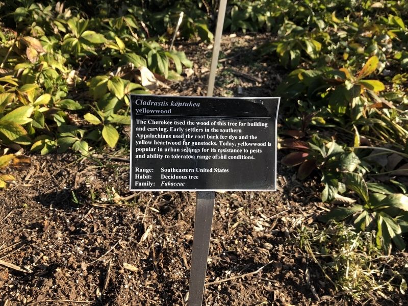
Near Meadow Road Northeast 0.1 miles west of Ellipse Road Northeast, on the left when traveling west.
The Cherokee used the wood of this tree for building and carving. Early settlers in the southern Appalachians used the root bark for dye and the yellow heartwood for gunstocks. Today, yellowwood is popular in urban settings for its resistance to . . . — — Map (db m144694) HM
Near Meadow Road Northeast 0.1 miles east of Eagle Nest Road Northeast, on the left when traveling west.
The leaves of this herb were thrown on fires by the Potawatomi of Michigan to create a smudge to deter mosquitos. The Ojibwe used the leaves for a tea to cure stomach cramps. — — Map (db m144611) HM
Near Meadow Road Northeast east of Eagle Nest Road Northeast, on the right when traveling east.
The seeds were drunk in wine by scorpion-bite victims. It was said that the plant, when placed against a scorpion, would cause temporary paralysis in the animal. Plant is poisonous. — — Map (db m235717) HM
Near Meadow Road Northeast 0.1 miles east of Eagle Nest Road Northeast, on the left when traveling west.
The stigmas are used in yellow food coloring and flavoring. Chemical analysis of ancient linens and mummies' winding sheets confirms its use as a dye. Today, it is used more as a spice and in cosmetics than as a textile dye. — — Map (db m144652) HM
Near Meadow Road Northeast just east of Eagle Nest Road Northeast, on the right when traveling east.
The flower petals contain a very strong dye, which on wool yields colors ranging from yellow and bronze to red, depending on the mordant and length of time simmered. Wild mountain dahlias were a source of red dye used by the Aztecs. — — Map (db m207114) HM
Near Meadow Road Northeast east of Eagle Nest Road Northeast, on the right when traveling east.
Early Mediterranean peoples used the root, boiled with wine and beaten until waxy as a salve for chapped skin. Little "worms found in the seed head were put in a purse and hung around the neck to cure fevers. — — Map (db m235720) HM
Near Meadow Road Northeast 0.1 miles east of Eagle Nest Road Northeast, on the left when traveling west.
The Plains Indians considered this herb to be one of the most important medicinal plants. Its root was the universal antidote for snakebites and all kinds of venomous bites and stings. — — Map (db m144605) HM
Near Meadow Road Northeast 0.1 miles east of Eagle Nest Road Northeast, on the left when traveling west.
In Dioscordes' time the young leaves of this prickly plant were pickled in brine and eaten as a pot herb. A drink of 'Eryngum' root diluted in honey liquor was said to cure epilepsy. — — Map (db m144654) HM
Near Eagle Nest Road Northeast 0.1 miles south of Meadow Road Northeast, on the left when traveling south.
The Meskwaki used the fresh outer bark, pounded into a poultice (compress), to heal facial sores. They steeped the inner bark to make an eye lotion. — — Map (db m144577) HM
Near Meadow Road Northeast 0.1 miles east of Eagle Nest Road Northeast, on the left when traveling west.
The Menomini used a decoction, or extract, of the root to treat the genitourinary tract. The Potowatomi made a poultice of fresh leaves to treat burns, and the Ojibwe bathed babies in a solution of the root to strengthen them. — — Map (db m144569) HM
Near Meadow Road Northeast 0.1 miles east of Eagle Nest Road Northeast, on the left when traveling west.
The northern Iroquois used the leave to make a tea that was considered a tonic and cure for colds and fevers
This herb may damage the liver. — — Map (db m144612) HM
Near Meadow Road Northeast east of Eagle Nest Road Northeast, on the right when traveling east.
This plant was used in broth to help people lose weight. The leaves were also used to flavor fish dishes and to help babies who had indigestion. — — Map (db m235713) HM
Near Eagle Nest Road Northeast 0.1 miles south of Meadow Road Northeast, on the left when traveling south.
The Meskwaki of Minnesota pounded the astringent root of this geranium in an animal bladder to make a poultice for hemorrhoids. — — Map (db m144596) HM
Near Meadow Road Northeast just east of Eagle Nest Road Northeast, on the right when traveling east.
The upper root drunk with wine provoked lust, Dioscorides said, and the lower root took away lust. Mashed with frankincense and wine, it was used to draw out splinters. — — Map (db m207112) HM
Near Meadow Road Northeast 0.1 miles east of Eagle Nest Road Northeast, on the left when traveling west.
According to Cherokee belief, the roots of sneezeweed and Veronica noveboracensis steeped in warm water acted as a contraceptive by preventing menstruation for two years. — — Map (db m144614) HM
Near Meadow Road Northeast east of Eagle Nest Road Northeast, on the right when traveling east.
Young leaves of this plant were eaten in salads. Medicinally, it was considered useful against scurvy, a disease brought on by a lack of Vitamin C. — — Map (db m235712) HM
Near Meadow Road Northeast 0.1 miles east of Eagle Nest Road Northeast, on the left when traveling west.
The root, a powerful astringent, was used by Choctaw, Chickasaw and Creek of the Southeast when conditions required an astringent or "puckering" medicine. — — Map (db m144613) HM
Near Meadow Road Northeast east of Eagle Nest Road Northeast, on the right when traveling east.
Barley is believed to be the first grain used for fermenting into beer. Due to its high levels of starch-converting enzymes and its tolerance of drought, cold, and poor soil conditions, barley is considered to be a distiller's "best friend". It . . . — — Map (db m235684) HM
Near Eagle Nest Road Northeast 0.1 miles south of Meadow Road Northeast, on the left when traveling south.
Native American medicinal uses of the root included treatment of the eyes and skin and for cancers and venereal diseases. The yellow root provided dye.
This plant should be avoided during pregnancy. — — Map (db m144572) HM
Near Meadow Road Northeast 0.1 miles east of Eagle Nest Road Northeast, on the left when traveling west.
Yaupon was a common drink of the Southeastern tribes, taken mainly for its emeting (vomit-inducing) action, which was a means of purification.
The fruit is poisonous. — — Map (db m144604) HM
Near Meadow Road Northeast 0.1 miles east of Eagle Nest Road Northeast, on the left when traveling west.
The common name for this plant comes from its purported use as a Native American smoke. It was used by the Seneca as an emetic (vomit-inducer) and for coughs.
The whole plant is poisonous. — — Map (db m144621) HM
Near Meadow Road Northeast 0.1 miles east of Eagle Nest Road Northeast, on the left when traveling west.
American Indians used the leaves of this small tree to make a medicinal tea for the treatment of chills, colds, and other ailments. Early American physicians used it as a quinine substitute as well as to treat gout, rheumatism, and respiratory . . . — — Map (db m144692) HM
Near Meadow Road Northeast east of Eagle Nest Road Northeast, on the right when traveling east.
Mint was once a popular strewing herb in Italian churches. Several mints yield useful essential oils, and the dried leaves are added to potpourri. Peppermint and spearmint are used in perfumery as well as to scent soaps and toothpastes. — — Map (db m235693) HM
Near Meadow Road Northeast 0.1 miles east of Eagle Nest Road Northeast, on the left when traveling west.
The St. Lawrence Montagnai considered the cooked berries a fever medicine. The dried leaves were added to Chippewa smoking mixtures. — — Map (db m144622) HM
Near Meadow Road Northeast just east of Eagle Nest Road Northeast, on the right when traveling east.
The leaves are used for making a gray-green or yellow dye, depending on the mordant used. This was one of the dye plants used by early American colonists. The wax is considered toxic. — — Map (db m207121) HM
Near Meadow Road Northeast east of Eagle Nest Road Northeast, on the right when traveling east.
Dioscorides said that the seeds were crushed and inhaled to relieve coughs. They were also drunk with wine to ease breathing afflictions. Soaked in vinegar, the seeds provided a mouthwash and relieved toothache. — — Map (db m235716) HM
Near Meadow Road Northeast east of Eagle Nest Road Northeast, on the right when traveling east.
An excellent source of gamma linoleic acid, evening primrose helps regulate hormonal balance. Current research confirms its traditional use for alleviating menstrual ailments. It is also used to treat eczema and holds promise for alleviating other . . . — — Map (db m235695) HM
Near Eagle Nest Road Northeast 0.1 miles south of Meadow Road Northeast, on the left when traveling south.
Sweet Cicely roots taste and smell like anise. Oil from the roots contains sugar, fats, resins and tannin. Chippewa Indians women drank the tea of the roots to aid in childbirth. — — Map (db m144601) HM
Near Meadow Road Northeast east of Eagle Nest Road Northeast, on the right when traveling east.
Sweet Cicely roots taste and smell like anise. Oil from the roots contains sugar, fats, resins, and tannin. Chippewa Indian women drank the tea of the roots to aid in childbirth. — — Map (db m235703) HM
Near Meadow Road Northeast 0.1 miles east of Eagle Nest Road Northeast, on the left when traveling west.
In the spring, the Menomini limited their diet to the young coiled fern tips (croziers) so that their bodies had the scent of the fern. This allowed them to get close to deer to hunt them. — — Map (db m144566) HM
Near Meadow Road Northeast east of Eagle Nest Road Northeast, on the right when traveling east.
Drinking the seed with honey and water was said to help indigestion. Poulticed leaves and flower heads helped to heal inflammations. A decoration applied with hot moist cloths induced sleep. — — Map (db m235719) HM
Near Meadow Road Northeast east of Eagle Nest Road Northeast, on the right when traveling east.
Among the world's oldest medicines, its pain relieving and sedative properties have been recognized for thousands of years. Its constituents include the well known alkaloids morphine and codeine. It was used to treat dysentery during the U.S. Civil . . . — — Map (db m235698) HM
Near Eagle Nest Road Northeast 0.1 miles south of Meadow Road Northeast, on the left when traveling south.
The Pamunkey of Virginia treated rheumatism with boiled poke berries. Several tribes used berry pigments as a dye.
All parts of the plant are poisonous. — — Map (db m144571) HM
Near Meadow Road Northeast 0.1 miles east of Eagle Nest Road Northeast, on the left when traveling west.
Native Americans made use of poke berries as a body paint. Later the Colonists found it an inexpensive source of red dye for woolens. Young leaves yield brilliant yellows on wool.
Caution: poisonous — — Map (db m144660) HM
Near Meadow Road Northeast east of Eagle Nest Road Northeast, on the right when traveling east.
The fruit of this woodland flower was eaten by all the Eastern tribes. The rhizome was ingested by the Iroquois to commit suicide.
The whole plant, except ripe fruit, is poisonous. — — Map (db m235707) HM
Near Eagle Nest Road Northeast 0.1 miles south of Meadow Road Northeast, on the left when traveling south.
This plant was called the "reviver" by the Menomini and Fox because inhaling the smoke of the heated root revived unconscious patients. — — Map (db m144578) HM
Near Meadow Road Northeast east of Eagle Nest Road Northeast, on the right when traveling east.
This grass has been a source of sugar for at least 5,000 years, and sugar was the original sweetener of choice in the beverage industry. Cane juice, molasses, and falernum syrup are all made from this plant, and are used in the brewing of stouts or . . . — — Map (db m235690) HM
On Meadow Road Northeast just east of Eagle Nest Road Northeast, on the right when traveling east.
The root has an orange-red dye that was used to paint the Meskwaki Indian warriors and to dye Rush mats made by the women. Narragansett Indians used the root as a cosmetic. — — Map (db m207120) HM
Near Meadow Road Northeast 0.1 miles east of Eagle Nest Road Northeast, on the left when traveling west.
The Cahuilla of southern California believed a tea made from this plant to be an effective remedy for reducing fevers and curing colds. — — Map (db m144618) HM
Near Meadow Road Northeast east of Eagle Nest Road Northeast, on the right when traveling east.
Research has validated the historic use of this plant for liver problems. Its active constituents help detoxify the liver and spur the regeneration of liver cells. As a result, it is useful for treating liver damage associated with alcohol abuse and . . . — — Map (db m235701) HM
Near Eagle Nest Road Northeast 0.1 miles south of Meadow Road Northeast, on the left when traveling south.
Smoke from the burning root was used by the Meskwaki to revive unconscious patients, to hush a crying child, and to cast spells. — — Map (db m144573) HM
Near Meadow Road Northeast 0.1 miles east of Eagle Nest Road Northeast, on the left when traveling west.
A decoction of the root was used for female diseases and to bring on childbirth by some tribes; others used it to treat headaches and rheumatism. — — Map (db m144606) HM
Near Meadow Road Northeast 0.1 miles east of Eagle Nest Road Northeast, on the left when traveling west.
The Chippewa made pemmican (high-energy food) by adding dried blueberries to moose fat and deer tallow. Native Americans also made a tea of blueberry roots to treat diarrhea and to ease childbirth. — — Map (db m144610) HM
Near Meadow Road Northeast just east of Eagle Nest Road Northeast, on the right when traveling east.
It contains the yellow dye substance luteolin and produces a range of olives and grays on wool. The flowers were used by Roman women as a hair colorant, and ashes of the burned plant were used to restore graying hair. — — Map (db m207113) HM
Near Meadow Road Northeast east of Eagle Nest Road Northeast, on the right when traveling east.
The tops of the dried stalks were dipped in fat and used as torches. Dried leaves of mullein were used in tea to help stop coughing. Soft leaves used fresh as socks for insulation and sometimes for diapers. — — Map (db m235714) HM
Near Meadow Road Northeast 0.1 miles east of Eagle Nest Road Northeast, on the left when traveling west.
The black roots contain a substance with powerful emetic (vomit-inducing) and cathartic (bowel-purging) properties which was used by the Senecas and Menomini.
This root is potentially toxic. — — Map (db m144602) HM
On Hickey Hill Road Northeast north of Holly Spring Road Northeast, on the right when traveling east.
Ginkgos are living survivors of the dinosaur period. They have been around for over 200 million years and haven't changed much. If the ginkgo hadn't been preserved in temples in China, Japan, and Korea it wouldn't be here today. Ginkgos are . . . — — Map (db m315537) HM
On Meadow Road Northeast east of Eagle Nest Road Northeast, on the right when traveling east.
From the mountainous areas to the desert and the tropics, salvias commonly known as sage, can be found growing everywhere in the world except Australia and Antarctica. These members of the Mint Family have every imaginable variation in leaf . . . — — Map (db m235680) HM
On Calvert Street Northwest at 20th Street Northwest, on the right when traveling west on Calvert Street Northwest.
In 2013, Howard University archaeologists, working with concerned citizens, completed a seven-year survey of Walter C. Pierce Community Park. Their goal, to identify and protect two historic cemeteries—the Colored Union Benevolent . . . — — Map (db m236781) HM
On 16th Street Northwest just south of Fuller Street Northwest, on the right when traveling south. Reported permanently removed.
The first researcher of the Cult of Spirits and Shamanism in Siberia.
She was the second European to receive a doctorate in Anthropology and taught at many of the world's universities.
A researcher of customs, author of books and . . . — — Map (db m210085) HM
On Fuller Street Northwest at 16th Street Northwest, on the left when traveling west on Fuller Street Northwest. Reported permanently removed.
People
Do you know
🌍 the name of the man who discovered that the Earth revolves around the Sun?
☢️ And do you know who was the only woman to win two Nobel prizes?
• Do you know who . . . — — Map (db m200379) HM
On 16th Street Northwest 0.1 miles north of Fuller Street, on the right when traveling north. Reported missing.
La Lotería Mexicana 🏳️🌈
La lotería es un juego similar al bingo que se originó en Italia en el siglo XV, pero en donde ha dejado huella en la cultura popular y las costumbres, ha sido en México. . . . — — Map (db m177212) HM
On Massachusetts Avenue Northwest west of 17th Street Northwest, on the left when traveling west.
Biruni, born in western Uzbekistan, was a Renaissance genius five centuries before the European Renaissance. A deep-dyed polymath, he founded the field of mineralogy, mapped the known world more precisely than anyone before him, and made lasting . . . — — Map (db m299221) HM
On Massachusetts Avenue Northwest west of 17th Street Northwest, on the left when traveling west.
Discover Uzbekistan!
Uzbekistan is located in the heart of Central Asia, the Republic of Uzbekistan is famous for its numerous architectural monuments, incredible natural landscapes, magnificent palaces, ruins of fortresses of past . . . — — Map (db m299220) HM
On 22nd Street Northwest just north of G Street Northwest, on the left when traveling north.
In Greek mythology, Helios was imagined as a handsome god crowned with the shining aureole of the sun. He drove the chariot of the sun across the sky each day to the earth—circling Oceanus and returning through the world-ocean to his palace in . . . — — Map (db m198007) HM
On Constitution Avenue Northwest (U.S. 50) west of 17th Street Northwest, on the right when traveling west.
English:
An Inuksuk is a northern stone land marker used by the Inuit for navigation, communication and to mark hunting and fishing grounds; it symbolizes the traditional Inuit way of life.
Canada presented the Inuksuk to the . . . — — Map (db m114937) HM
A labyrinth consists of a winding path leading to and from a center with only a single entrance. There are no dead ends or blind corners and nothing to "figure out." Often considered to be a method of meditation, contemplation, and relaxation, . . . — — Map (db m248776) HM
Near 31st Street Northwest at Avon Lane Northwest, on the right when traveling south.
In the early 19th century, this area was a hub of domestic activity with a detached kitchen, laundry, and smokehouse. Archaeological excavations in 2017 revealed an assortment of objects related to the uses of the space, including animal bone, . . . — — Map (db m241122) HM
Near Pennsylvania Avenue Northwest (Alternate U.S. 1) east of Constitution Avenue Northwest (Alternate U.S. 1), on the right when traveling west.
[Français:]
L'ambassade du Canada est frière d'accueillir la sculpture la plus grande et la plus complexe ayant été réalisée par l'artiste haïda Bill Reid: une sculpture en bronze coulé qui représente un canot transportant treize . . . — — Map (db m248467) HM
On 13th Street Northwest north of Logan Circle Northwest, on the right when traveling south.
Bullomun is a gate made entirely of a single piece of granite. Translated as the gate of eternal youth, ancient Koreans believed that if you pass through the gate, you will be promised with such fortunes. This Bullomun gate was created . . . — — Map (db m284997) HM
On Sherman Avenue Northwest at Columbia Road Northwest, on the right when traveling north on Sherman Avenue Northwest.
The House at 3017 Sherman Avenue once was a boardinghouse for Howard University students. In 1923 a determined and talented young woman from the tiny town of Eatonville, Florida, lived here while earning an Associates Degree at Howard. In a . . . — — Map (db m130759) HM
On S Street Northwest at 22nd Street Northwest, on the right when traveling west on S Street Northwest.
Mitchell Park was the site of the two-story brick Holmead farmhouse built in 1795 by Anthony Holmead. The house remained in the hands of the Holmead descendants until the 20th century. In 1929 the house was razed by the German government which . . . — — Map (db m113372) HM
On Olmsted Walk 0.3 miles east of Connecticut Avenue Northwest, on the right when traveling east.
Bison were a means to an end.
To Native Americans, bison were a source of food, tools, warmth and shelter. To American settlers, they were food, but they were also in the way; bison thrived on the same land that the growing nation wanted. . . . — — Map (db m184422) HM
On Nebraska Avenue Northwest north of New Mexico Avenue Northwest, on the right when traveling south.
While wooden carved statues called Jang-seung traditionally stood on the Korean mainland, stone-carved statues called Dolhareubang stood on the volcanic island of Jeju.
Historically, Dolhareubang were erected at the entrances of the areas most . . . — — Map (db m117829) HM
On Nebraska Avenue Northwest south of New Mexico Avenue Northwest, on the right when traveling south.
The residents of Jeju Island did not require gates, but instead utilized long, horizontally placed wooden poles placed outside the entrances of their homes. These wooden poles are called Jeong-nang and they are supported by two large vertical stone . . . — — Map (db m117827) HM
On Van Buren Street Northwest just west of 3rd Street Northwest, on the left when traveling east.
Takoma Recreation Center sits on the outskirts of the Takoma Park Historic District, Washington's first railroad suburb, straddling the border with Maryland and developed by Benjamin Franklin Gilbert beginning in 1883. A resident had proposed . . . — — Map (db m196558) HM
On 12th Street Northwest at Constitution Avenue Northwest (U.S. 50), on the right when traveling south on 12th Street Northwest.
More than 1,200 wildlife species in the United States—including mammals, birds, fish, reptiles, amphibians, and insects—depend on dead or dying wood for their habitats.
What's the Snag?
A snag is a standing dead, or dying, tree. Snags . . . — — Map (db m188503) HM
On Madison Drive Northwest just east of 14th Street Northwest, on the right when traveling west.
Butterflies and bees love this plant, and so do people! Anise hyssop is named for its licorice-like scent. Used for tea by early Native Americans, it is also delicious in jellies and even cookies. The Latin word foeniculum refers to . . . — — Map (db m164289) HM
On Constitution Avenue Northwest (U.S. 50) east of 12th Street Northwest, on the right when traveling east.
This portrait of an Olmec ruler is among 17 colossal heads known from one of the world’s great ancient civilizations. Without wheels or iron tools, the Olmec created spectacular monumental sculptures and ceremonial centers on Mexico’s Gulf Coast. . . . — — Map (db m39628) HM
On Constitution Avenue Northwest (U.S. 50) just west of 10th Street Northwest, on the right when traveling east.
This portrait of an Olmec ruler is among 17 colossal heads known from one of the world's great ancient civilizations. Without wheels or iron tools, the Olmec created spectacular monumental sculptures and ceremonial centers on Mexico's Gulf Coast. . . . — — Map (db m211272) HM
Near 14th Street Northwest (U.S. 1) south of Constitution Avenue Northwest (U.S. 50), on the left when traveling south.
Many peoples and their plants have left a mark on the American landscape. Our gardens include plants that were found here, brought from other countries, or passed down by seed or shared with neighbors. These plants now represent a shared American . . . — — Map (db m211383) HM
Near Madison Drive Northwest just east of 14th Street Northwest (U.S. 1), on the right when traveling west.
Many peoples and their plants have left a mark on the American landscape. Our gardens include plants that were found here, brought from other countries, or passed down by seed or shared with neighbors. These plants now represent a shared American . . . — — Map (db m211384) HM
Near Madison Drive Northwest just east of 14th Street Northwest (U.S. 1), on the right when traveling west.
Many peoples and their plants have left a mark on the American landscape. Our gardens include plants that were found here, brought from other countries, or passed down by seed or shared with neighbors. These plants now represent a shared American . . . — — Map (db m211390) HM
Near Madison Drive Northwest west of 12th Street Northwest, on the right when traveling west.
Many peoples and their plants have left a mark on the American landscape. Our gardens include plants that were found here, brought from other countries, or passed down by seed or shared with neighbors. These plants now represent a shared American . . . — — Map (db m211394) HM
Near Madison Drive Northwest west of 12th Street Northwest, on the right when traveling west.
Many peoples and their plants have left a mark on the American landscape. Our gardens include plants that were found here, brought from other countries, or passed down by seed or shared with neighbors. These plants now represent a shared American . . . — — Map (db m211402) HM
Near Madison Drive Northwest just east of 14th Street Northwest (U.S. 1), on the right when traveling west.
Many cultures contributed to America's landscape. Each brought insights as people shared new and unfamiliar plants and their uses. Explorers, botanists, horticulturalists, and home gardeners continue to introduce new plants to American gardens. . . . — — Map (db m211388) HM
Near Madison Drive Northwest west of 12th Street Northwest, on the right when traveling west.
Many cultures contributed to America's landscape. Each brought insights as people shared new and unfamiliar plants and their uses. Explorers, botanists, horticulturalists, and home gardeners continue to introduce new plants to American gardens. . . . — — Map (db m211397) HM
Near Madison Drive Northwest at 14th Street Northwest, on the right when traveling west.
On the shores of our present, we are met by the waves of our past. Many disasters of our world—racism, resource extraction, poverty—emerged from slavery and colonialism. But so do the seeds of hope, sown by historic freedom . . . — — Map (db m289627) HM
On 12th Street Northwest just south of Constitution Avenue Northwest (U.S. 1/50), on the right when traveling south.
Also called "greasy collards" because of their waxy shiny leaves, Green Glaze collards originated in the 1820s, making them the oldest collards grown in the Southeast. They are a staple of Southern cuisine, and are often cooked down with meats, . . . — — Map (db m211414) HM
Near Madison Drive Northwest just east of 14th Street Northwest (U.S. 1), on the right when traveling west.
Many plants have a history of providing comfort, restoration, and inspiration. Different communities found medicinal purposes for plants and passed down knowledge from generation to generation. People sought answers for common ailments, spiritual . . . — — Map (db m211387) HM
Near Madison Drive Northwest east of 14th Street Northwest (U.S. 1), on the right when traveling west.
Clever gardeners used plants to overcome obstacles, and found solutions to allow desired plants to thrive.
Whether with a lack of resources or an abundance of opportunity many minds came together to create networks and industries to serve . . . — — Map (db m211389) HM
Near Madison Drive Northwest west of 12th Street Northwest, on the right when traveling west.
Clever gardeners used plants to overcome obstacles, and found solutions to allow desired plants to thrive.
Whether with a lack of resources or an abundance of opportunity many minds came together to create networks and industries to serve . . . — — Map (db m211400) HM
On 15th Street Northwest just south of Constitution Avenue Northwest (U.S. 50), on the left when traveling south.
Early Conservation Efforts
In the past, live oaks were so valuable to shipbuilding and U.S. national security that in the early 1800s Congress passed laws to prevent them from being harvested illegally. The U.S. government also purchased and . . . — — Map (db m143310) HM
On Madison Drive Northwest east of 14th Street Northwest (U.S. 1), on the right when traveling west.
Native communities and newcomers have shared plants and adapted them for their own personal use. Many plants native to the Americas have been used for food and fiber and honored as elements of cultural heritage. People brought plants as heirlooms . . . — — Map (db m211385) HM
Near Madison Drive Northwest west of 12th Street Northwest, on the right when traveling west.
Native communities and newcomers have shared plants and adapted them for their own personal use. Many plants native to the Americas have been used for food and fiber and honored as elements of cultural heritage. People brought plants as heirlooms . . . — — Map (db m211395) HM
Near Madison Drive Northwest west of 12th Street Northwest, on the right when traveling west.
Alliums include edible onions, garlic, leeks, and chives. Plant explorers have also collected non-edible or "ornamental" varieties with globe-like flowers from around the world to breed new sizes and colors for gardens.
Did you know that . . . — — Map (db m211403) HM
4210 entries matched your criteria. Entries 401 through 500 are listed above. ⊲ Previous 100 — Next 100 ⊳