On Chambers Avenue just north of Marks Street, on the left when traveling north.
Site of school built in 1894 for African American students. First principal, Charles Steele was founder of the school and of black education in Georgetown. He served until his death in 1908. Edward B. Davis, principal 1908-34, added a two-year . . . — — Map (db m163154) HM
On Frankfort Pike (U.S. 460) 0.1 miles east of Stamping Ground Road (Kentucky Road 227), on the right when traveling west.
The U.S. government established at Blue Springs Farm. Home of Vice President R.M. Johnson. Its first Indian school for sons of Indian chiefs. Future leaders of many tribes were educated here. — — Map (db m60025) HM
On West College Street just west of South Broadway Street (U.S. 25), on the right when traveling west.
The roots of Georgetown College go back to 1788, when Baptist minister Elijah Craig began an academy which offered classical education--Latin, Greek, and sciences. This early school was in large log house near corner of South Broadway and West . . . — — Map (db m163152) HM
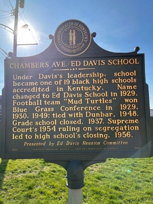
On Broadway Street (U.S. 25) just south of Jackson Street, on the right when traveling north.
First public school in Ky. built by the holding company plan, in which bonds were sold to build the school until construction costs could be paid. Garth was opened in 1926 on the site of the former Georgetown Female Seminary. Bricks from the . . . — — Map (db m165187) HM
On E. Main Street (U.S. 62, 460) at Memorial Drive, on the left when traveling west on E. Main Street.
First Baptist College west of the Alleghenies. Chartered in January, 1829, by "The Trustees of the Kentucky Baptist Education Society." Later named Georgetown. The site of Rittenhouse Academy, Georgetown, chosen for the College, July, 1829. Giddings . . . — — Map (db m70524) HM
On Military Street (Kentucky Route 1962) south of East College Stret, on the left when traveling south.
Hambrick Village is named in honor of Dr. Horace Thomas Hambrick
and Maribeth Porter Hambrick, both members of the Class of 1949.
The Hambrick and Porter families have touched the life of Georgetown
College in immeasurable ways. Horace and . . . — — Map (db m202940) HM
On South Weisenberger Mill Road at Zion Hill Lane, on the right when traveling south on South Weisenberger Mill Road.
Zion Hill
Established prior to the end of
slavery. Originally known as South
EIkhorn Bend & Lenerson. The name
was later changed to Zion Hill. It
was a prominent African American
community with two stores. church,
and post office. . . . — — Map (db m170033) HM
On Weisenberger Mill Road, 0.6 miles south of Leestown Road (U.S. 62/421), on the right when traveling south.
Located off Paynes Depot Road in Scott County, Zion Hill is one
of several remaining hamlets in central Kentucky. Hamlets were
established by formerly enslaved persons in Scott County and other
surrounding counties after the Civil War. Residents . . . — — Map (db m170103) HM
On Washington Street (Business Kentucky Route 55) at 3rd Street, on the right when traveling west on Washington Street.
Birthplace of Governor Augustus Owsley Stanley
A. O. Stanley, Governor of Ky. from 1915-19, was born May 21, 1867, in Shelbyville and lived in this house as a child. The son of Rev. Wm. and Amanda Owsley Stanley, he was school principal . . . — — Map (db m136869) HM
On Washington Street (Business Kentucky Route 55) at 6th Street, on the right when traveling west on Washington Street.
For 114 continuous years, an outstanding school for girls. Directed by the founder 54 years then by one family 60 years, it ranked among nation's foremost college preparatory schools.
Principals
Mrs. Julia A. Tevis 1825-1879
W. T. . . . — — Map (db m136854) HM
On Shelbyville Road (U.S. 60) at Whitney Young, on the right when traveling east on Shelbyville Road.
Founded by Berea College trustees with Pres. Frost main fundraiser. This occurred after Day Law (1904) stopped coeducation of whites and blacks. In 1909, Berea board bought three farms totaling 444 acres for a school. Lincoln Institute opened to 85 . . . — — Map (db m136845) HM
On Shelbyville Road (U.S. 60), on the right when traveling east.
Civil rights leader born here. Son of distinguished educator, Dr. Whitney M. Young, Sr. Served in US Army, World War II. Graduated Ky. State College, 1941; U. of Minn., 1947. Director of Urban Leagues in Minn. and Neb., 1947-53. Dean of School of . . . — — Map (db m136849) HM
On Steele Road, 0.1 miles south of Nashville Road (U.S. 31W), on the left when traveling south.
A higher standard of living means more leisure time. Local attractions include the drive-in, Kenny Perry's golf course, and horse racing at Kentucky Downs. Interstate 65 spurs commerce and travel. A tech school bolsters education. — — Map (db m83899) HM
On Steele Road, 0.1 miles east of Nashville Road (U.S. 31W), on the left when traveling south.
City and county schools consolidated in the 1940s and integrated in the 1960s. Actress Annie Potts was a cheerleader in the early 1970s. Dr. David Patterson was valedictorian a decade later. School teams have won many championships. — — Map (db m83901) HM
On Steele Road, 0.1 miles south of South Main Street (U.S. 31W), on the right when traveling north. Reported damaged.
Birthplace of T.O. Chisholm
Thomas Obadiah Chisholm, born in log house, Lake Spring community, taught in local school at age 16. Became associate editor of Franklin Favorite; later edited Pentecostal Herald, Louisville. . . . — — Map (db m83296) HM
On West Cedar Street (State Highway 100) at North Main Street (U.S. 31W), on the right when traveling west on West Cedar Street.
Carrie Conn Moore, the first woman to serve in the Kentucky Senate, was born in Logan Co. on January 7, 1904. She moved to Franklin when she married J. Lee Moore. After her husband's death, she won a special election in Nov. 1949 to fill the . . . — — Map (db m159146) HM
On Walker Street west of John J. Johnson Avenue, on the right when traveling west.
The original Lincoln School was formally dedicated on Sunday, September 8, 1940. The two-story building was a hallmark for the Black Community and marked a new beginning for education. The life of the school was interwoven with the fabric of the . . . — — Map (db m159167) HM
On Walker Street west of John J. Johnson Avenue, on the right when traveling west.
A hallmark of the black community, it was dedicated on September 8, 1940 and G.R. Houston served as its first principal. In 1944, county schools merged with Lincoln, which brought about crowded conditions. School added onto several times from . . . — — Map (db m159162) HM
On Elk Creek Road (Kentucky Route 1633) near Plum Ridge Road (Kentucky Route 1169), on the right when traveling north.
The Blind Bard of Kentucky was blind by fifteen and deaf before forty. Neither condition limited his contributions. As friends read aloud, he embossed notes on the Diplograph machine he invented and built. He invented the Talking Glove with the . . . — — Map (db m136841) HM
On East Broadway (Kentucky Route 68) at North Columbia Avenue, on the right when traveling east on East Broadway.
Born 1763. Died 1843. Served in Rev. War from Culpeper Co., Va. His five brothers, Daniel, John, Joshua, Thomas and William, also served in Revolution. Elias Barbee came early to what is now Taylor County. Lived eight miles N.W. of Campbellsville. . . . — — Map (db m208464) HM
On Goebel Avenue, on the right when traveling east.
In 1835, residents opened the Green River Female Academy to provide a local education for girls. To fund the school, trustees sold subscriptions of stock. They commissioned the erection of this three-story brick Federal and Greek Revival style . . . — — Map (db m136783) HM
On Cherry Street at 3rd Street, on the left when traveling east on Cherry Street.
Side One
A native of Guthrie, Warren was one of the nation's most prolific writers, a world-renowned man of letters. Graduate of Vanderbilt Univ., member of the Fugitives (writers group). Rhodes scholar at Oxford, 1928-1930; and twice a . . . — — Map (db m108850) HM
On South Main Street (U.S. 41) at 6th Street, on the left when traveling south on South Main Street.
Trenton School was built in 1920 through the initiative of the citizens of Trenton, Kentucky. Funds were donated and the Board of Trustees personally borrowed the balance of the funds needed to complete construction of the school. Students from the . . . — — Map (db m171874) HM
On Linton Road (Kentucky Route 164) at Donaldson Creek Road (Kentucky Route 807), on the right when traveling south on Linton Road.
One-room log structure, known as Dixon School, built 350 yds. S. W. in 1881. After building burned, new school was constructed in 1913; approximately 50 students attended each year. Pupils often competed with other schools in athletic and scholastic . . . — — Map (db m179502) HM
On Donaldson Creek Road (Kentucky Route 807) 0.2 miles west of Old Dover Road, on the right when traveling west.
Organized 1813, this grade school operated for 135 years. First teacher was Ephriam Cowand, whose salary was 4 barrels of corn and $2.00 per pupil. School met first at Donaldson Creek Church 1½ mi west: later used nearby log cabin, 1815-1910. . . . — — Map (db m179526) HM
On Beechy Fork Road west of Maple Grove Road (Kentucky Route 1062), on the left when traveling west.
An early log schoolhouse first was opened by teacher William Bridges (1800-1844), son of settlers Drury and Charity Bridges. Education continued in new concrete block school, erected in 1913. After serving the Trigg County community for many years, . . . — — Map (db m179541) HM
On U.S. 60 at 141S (U.S. 60), in the median on U.S. 60.
Sisters of Charity from Nazareth - Angela Spink, Frances Gardiner and Cecily O'Brien - arrived here, 1820. They began a girls boarding school on this site on land of the Alvey family. With aid of Father Elisha Durbin, school gained renown. It . . . — — Map (db m159415) HM
On West Main Avenue just west of Barry Street, on the left when traveling west.
Dr. Henry Carpenter
After the Civil War, Bowling Green's west side became home to a growing number of the city's African Americans. Many owned their properties and worked hard to support their families. As the black population grew, the need . . . — — Map (db m143039) HM
Near Avenue of Champions just south of College Heights Boulevard, on the right when traveling east.
Became a college of Western Kentucky
University in 1963. Founded as part
of Glasgow Normal Institute in 1875.
School moved to Bowling Green in
1884. Was named Southern Normal
School and Business College. In 1907
the schools separated. The . . . — — Map (db m159181) HM
On College Heights Blvd. at College Avenue on College Heights Blvd..
Leader of the movement to establish Kentucky Normal Schools and teachers College.
President Southern Normal School 1892-1906. President Western Kentucky State Teacher's College1906- 1937. — — Map (db m47601) HM
On States Street at College Heights Avenue on States Street.
Founded here, 1877, with funds left by Robert Ogden, local businessman. Filled educational gap, as there were no public schools here until 1882. Prep school accredited in 1919. Ogden's criteria: regular attendance, gentlemanly deportment, diligent . . . — — Map (db m159191) HM
Omega Psi Phi Fraternity Inc. is the first international fraternal organization to be founded on the campus of a historically black college. Omega Psi Phi was founded on November 17, 1911, at Howard University in Washington, D.C. The founders were . . . — — Map (db m138763) HM
On State Street, 0.1 miles south of East 2nd Avenue, on the right when traveling south.
Ora Porter, born in Butler Co., in 1880, moved to Bowling Green at age 10. She graduated from Tuskegee Institute School of Nursing and was among the earliest registered nurses in Ky. She was an organizer of the George Washington Carver Community . . . — — Map (db m83334) HM
School for girls founded 1877 as Cedar Bluff Female College near Woodburn. Part of the staff moved to Bowling Green in 1899 and began Potter College. Located on Vinegar Hill, now part of the campus of Western Kentucky University. School closed in . . . — — Map (db m128332) HM
On East 2nd Avenue at State Street, on the right when traveling east on East 2nd Avenue.
Side 1
This African American community was founded in the 1800s. Bordered by the river and High, Ky., and 7th Sts., the area grew to include hundreds of residents, two schools, businesses, and churches. The architecture of Shake Rag . . . — — Map (db m83332) HM
On Liberty Way at Jones Drive, on the left when traveling west on Liberty Way.
Side 1 Named for Dr. Thomas Crittenden Cherry, who was superintendent of the Bowling Green schools for 32 years (1905-37). T. C. Cherry Elem. began educating children in the fall of 1950. It housed grades K-8, which included the first . . . — — Map (db m137086) HM
On College Heights Blvd, on the left when traveling north.
Side 1
The model training school opened September 17, 1906, on College Street. It offered 4 grades for Western teacher training. In 1911 moved to future site of Cherry Hall. Grades 5-8 added by 1913. Ties to city schools severed & 9th . . . — — Map (db m138735) HM
The W.L. "Gander" Terry Colonnade is named in honor of a Marion, Kentucky native, who was an excellent student and superior athlete at Western Kentucky University from 1924-1928. He was among the students who faithfully worked to convert this site . . . — — Map (db m47610) HM
On Riverview Drive (U.S. 31W) at College Street, on the right when traveling west on Riverview Drive.
Looking up College Street, one can view the cupola of Cherry Hall at Western Kentucky University. Western Kentucky University was founded in 1906 and achieved university status in 1966. Because of its unique location high above the city and . . . — — Map (db m143062) HM
On Bardstown Road west of St. Catharine College Drive, on the left when traveling west.
Cradle and Mother House of the Dominican Sisters in U.S. First settlement at St. Rose Farm, 1822. Known as St. Magdalen Academy from 1823 to 1851. Renamed, 1851, St. Catharine of Sienna. Mother Angela Sansbury, O.P., and Rev. S. T. Wilson, O.P., . . . — — Map (db m170101) HM
Under Pres. Roosevelt’s New Deal, $6500 was allocated to the WPA to build a new schoolhouse. It was completed in June 1938. Ten years later, building was deeded to the American Legion. Post was named Austin Collins in honor of a local boy who died . . . — — Map (db m88961) HM
On Walnut Street, on the right when traveling north.
This building was constructed in 1906 at a cost of $20,000 and known as the Reuben D. Hill Building. Name was changed to the Gray Brick Buidling when it was purchased, along with two other buildings, by the Williamsburg Institute in 1907 from . . . — — Map (db m119994) HM
On Main Street at College Street, on the right when traveling north on Main Street.
Founded as Williamsburg Institute in 1889 under the leadership of General Green Clay Smith and R. C. Medaris to provide affordable Christian education for mountain people. Early supporters were James P. and Thomas B. Mahan, Ancil Gatliff, Edwin S. . . . — — Map (db m119991) HM
On Main Street, on the left when traveling north. Reported missing.
Originally Johnson Hall, it was renamed Gillespie Hall in 1995. Built in 1893 and dedicated on February 11, 1894, in memory of William James Johnson, college's first president. Girls occupied the hall for first year; boys occupied the hall from . . . — — Map (db m120057) HM
On West Sycamore Street, on the left when traveling north. Reported missing.
Mahan Hall was constructed in 1906 for use as a dormitory for men at Cumberland College. Originally named Felix Hall in honor of board of trustees member, Dr. W. H. Felix of Lexington, Ky. Named changed to Mahan Hall, May 1954, in honor of E. C. . . . — — Map (db m120058) HM
On Main Street, on the right when traveling north.
Built in 1888 as the first building of Williamsburg Institute. First known as the "Institute," then an "Old Recitation Building." The land purchased for $800; contractor was J. A. Cooley. The $12,500 building served 200 pupils. First classes, Jan. . . . — — Map (db m119993) HM
Side 1 A Williamsburg native and Ky. State Univ. student, he was a World War II Tuskegee Airman and B-25 navigator and bombardier. He participated in the 1945 "Freemen Mutiny" where 101 black officers fought inequality by entering a . . . — — Map (db m74178) HM
Wolfe County, founded in 1860, is Eastern Kentucky’s Gateway to Appalachia. The National Designated Wild and Scenic Red River and the North Fork of the Kentucky River flow through Wolfe County. The woods are sculpted with sandstone arches, . . . — — Map (db m73872) HM
Organized 1880 by J. Taylor Day, William O. Mize and Green Berry Swango. Only college preparatory school serving this area for years. Many of its graduates have gone on to prominence. — — Map (db m146544) HM
On Kentucky Route 15, 0.1 miles south of Sky Bridge Road (Kentucky Route 715), on the right when traveling south.
The Methodist-sponsored Alvan Drew
school was here, 1913-1947. Started
by missionary Mrs. M. O. Everett,
and named for supporter of rural
education, it began as a one room
school and later added student-operated farm, blacksmith and . . . — — Map (db m146470) HM
On Lansing Lane, 0.7 miles south of Weisenberger Mill Road, on the left when traveling south.
Woodford's first county court met here, May 16, 1789. Caleb Wallace (1742-1814), Presbyterian minister from Va., was in Kentucky by 1783. He served on Supreme Court of District of Ky. and on Ky. Court of Appeals for 30 years. A founder of several . . . — — Map (db m202958) HM
On Walnut Street at Elkton Place, on the right when traveling east on Walnut Street.
Erected in 1872, this was the first church building for Pilgrim Baptist Church. In 1911, the Woodford Co. Bd. of Ed. purchased this property in “Haydensville” to be used as Midway Elem. School for African Americans. In 1936, sold to . . . — — Map (db m170032) HM
On East Stephens Street east of Smith Street (County Road 2012), on the left when traveling east.
The Freedmen's Bureau was created during Reconstruction to provide relief services for formerly enslaved Americans. The Midway Freedman's School opened in April 1867, inside the original Second Christian Church, on the grounds of the Ky Female . . . — — Map (db m206152) HM
On South Brand Street (at milepost 0.1) at East Cross Street, on the right when traveling north on South Brand Street.
Operated by Kentucky Female Orphan School since 1944. Orphan school was founded by James Parrish and Dr. Lewis L. Pinkerton. It was the first female orphan school in the United States. Chartered by 1846 Kentucky Legislature. Opened in 1849 with 14 . . . — — Map (db m205691) HM
On Versailles Road (U.S. 60) at Pisgah Pike (State Highway 1967), on the right when traveling west on Versailles Road.
[ Front: ]
Albert Benjamin Chandler
This colorful orator and two-term governor began his law practice in Versailles. As governor, he was driving force behind establishment of the University of Kentucky Medical Center, later named in his . . . — — Map (db m30839) HM
On Versailles Road (U.S. 60) at Pisgah Pike (State Highway 1967), on the right when traveling west on Versailles Road.
Pioneer Presbyterian Church, organized in 1784. Here Kentucky Academy opened in 1797. The school united with Transylvania University in 1798. — — Map (db m57504) HM
On Rose Hill Avenue, on the right when traveling west.
Whose headmaster was Professor Matt Gay Jesse, a superb educator and builder of character of his students.
Presented by his grateful alumni — 1967. — — Map (db m170014) HM
357 entries matched your criteria. Entries 301 through 357 are listed above. ⊲ Previous 100