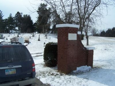
On McConkey Road (County Route 369), on the left when traveling south.
We sincerely thank the Pleasant Township Veterans
past, present and future for their courage
and devotion to duty and immeasurable sacrifice — — Map (db m92542) WM
On Fountain Avenue at North Market Place, on the right when traveling south on Fountain Avenue.
The Old City Building and Market, also known as the Municipal Building or Marketplace, was designed by local architect Charles A. Cregar. It was completed in 1890 at a cost of $250,000. Vendors, who sold meats, fish, provisions, vegetables, and . . . — — Map (db m13309) HM
On Limestone Street at Columbia Street, on the left when traveling north on Limestone Street.
A. B. Graham, superintendent of Springfield Township Rural schools in Clark County, established the "Boys and Girls Agricultural Experiment Club," which revolutionized agricultural education and non-formal youth development methods. The first . . . — — Map (db m13216) HM
On Main Street at Lowry Avenue, on the right when traveling west on Main Street.
This building erected AD 1915
by the People of Clark County
In memory of the
Soldiers, Sailors, Marines & Pioneers
of Clark County — — Map (db m13284) WM
On Tecumseh Road (Ohio Route 369) north of Lower Valley Pike, on the right when traveling north.
[Front Side of Marker]
Here
General
George Rogers
Clark
With his Kentucky soldiers
Defeated and drove
From this region
The Shawnee Indians
August 8 1780
Thus aiding to make
The Northwest Territory
Part of the . . . — — Map (db m35379) HM
On Westport Road (Kentucky Route 524) at 4th Street, on the right when traveling west on Westport Road.
First called Liberty, located on 1780 grant to Elijah Craig. Ferry operated here by Levi Boyer early as 1800 formed a link in route to Illinois country. Town became a port to the west -- Westport. In the steamboat era, the town was a thriving port . . . — — Map (db m42974) HM
Near Patrol Road 0.7 miles north of Collector Wells Road, on the right when traveling north.
Since the beginning of history, people have been drawn to the river for water, food and transportation.
1. The Earliest People Several archaeological sites at Charlestown reveal stories of temporary camps. Mounds in this region date from the . . . — — Map (db m206831) HM
On Bannack Road near State Highway 278, on the left when traveling east.
Sidney Edgerton arrived at Bannack from Ohio in September 1863 to begin his appointment as Chief Justice of the Supreme Court of Idaho Territory. The massive territory encompassed Idaho, all of Montana, and the western half of Wyoming, with the . . . — — Map (db m124263) HM
Near Urbana Road (Ohio Route 72) north of Route 334, on the right when traveling north.
Site of Simon Kenton's first log cabin home in Ohio - Built beside the old war trail over which he was led into captivity - Scene of his killing the last Indian slain in combat in Clark County — — Map (db m44177) HM
On South Limestone Street at East Pleasant Street, on the right when traveling east on South Limestone Street.
Created as a gift to Clark County residents to commemorate the February 26, 1998 50th anniversary of the Springfield Foundation this community garden is the result of the hard work and support of several community partners. In recognition of . . . — — Map (db m308985) HM
On Rocky Point Road (County Route 136) at Old Mill Road (County Route 146), on the left when traveling west on Rocky Point Road.
Listed on the National Register of Historic Places in 2009, the span is the oldest in Clark County a traveler can cross. It is also one of the oldest stone bridges in use in Ohio. Stone mason Samuel S. Taylor (1837-1930) built the culvert from . . . — — Map (db m135172) HM
On Route 47 at Route 245, on the right when traveling north on Route 47.
After the 1786 destruction of the Upper Mad River Shawnee villages, some Mekoches migrated northwest to a bountiful area known as the Grand Glaize along the Maumee River. Others relocated to Indiana, Missouri, and Kansas. However, the cruelty of . . . — — Map (db m307098) HM
On North Main Street (Business U.S. 460) at Jackson Street NE (Virginia Route 785), on the right when traveling north on North Main Street.
Just northeast stood the home of William Black, the founder of Blacksburg. In 1797, he laid out a 16-block grid and petitioned the Virginia General Assembly to incorporate a town here; the legislature approved his petition on 13 January 1798. On 4 . . . — — Map (db m41436) HM
On West Main Street west of South Central Avenue (Illinois Route 49), on the right when traveling west.
With the opening of the National Road through this area, small communities began to the established along the route, one of which was Casey. The first settler was John Lang, a native of Scotland. Lang and family arrived from Ohio in 1838 and bought . . . — — Map (db m152488) HM
On East Court Avenue at Spring Street, on the left when traveling east on East Court Avenue.
Jeffersonville is named for President Thomas Jefferson, who had a profound influence on the city. As a Virginia legislator, Jefferson was a strong supporter of General George Rogers Clark's Illinois campaign from 1778 to 1779, which resulted in the . . . — — Map (db m241638) HM
The one- room school was a common sight in rural Ohio
in the late 19th and early 20th centuries. Locust Grove
No. 12 housed elementary school classes until the late
1920’s on it’s original site; S. Bird Road at E. Possum
Road in Clark County, . . . — — Map (db m218040) HM
Near Duncan Road 0.6 miles south of Boydton Plank Road (U.S. 1), on the left when traveling south.
The breaking of the lines at Petersburg sparked major events that followed in quick succession - the evacuation and capture of Richmond, the pursuit to Appomattox, the surrender of Lee's Army, and the assassination of Abraham Lincoln. This . . . — — Map (db m285353) HM
Squire Bozorth 1792-1853
Cowlitz County Kentucky Militia
•
George Bush 1789/90-1863
Thurston County Kentucky Militia
•
Asa Coombs 1796-1888
King County Tennessee Militia
•
Walter Crockett 1786-1869
Island County . . . — — Map (db m308907) WM
Near Ohio River Scenic Byway 0.1 miles west of Main Street, on the left when traveling west.
The Ohio River between Clark County, Indiana and Louisville, Kentucky, provides a treasure of historic bridges. The first bridge to your left is the George Rogers Clark Memorial Bridge, completed in Art-Deco style in 1929. Its original name was the . . . — — Map (db m198392) HM
On Spangler Road at East Main Street, on the right when traveling north on Spangler Road.
The Powerhouse at Medway
In 1899 the Dayton, Springfield & Urbana Railway began construction of a new powerhouse. The existing millrace supplied the water for a steam generation system for direct current electricity, and the plant was . . . — — Map (db m175278) HM
On West Main Street west of South Isabella Street, on the left when traveling west.
The Act of Congress in 1806, which authorized the construction of the National Road, required that mile markers be placed at regular intervals. These reference points reassured travelers that they were following the correct route. They also . . . — — Map (db m175105) HM
On East Main Street west of Mill Street, on the right when traveling east.
Imagine you're traveling the National Road in the late 1800s. Your wagon is one of many trundling toward town. The dirt road is rough and the ride uncomfortable, but you welcome the trip. It's a day to visit with friends, catch up on news, and trade . . . — — Map (db m152560) HM
Near Ford Road/4 Mile Road (Kentucky Route 1924) 1.2 miles south of Boonesboro Road ( Route 627), on the left when traveling south.
Constant Confederate Raids Forced the Union Army to Take Action
In the spring and summer of 1863 Confederate raids led by Col. Roy S. Cluke, Gen. John Pegram and Col. John S. Scott crossed and recrossed the Kentucky River. Their mission . . . — — Map (db m74678) HM
On National Road (U.S. 40) at Patterson Road, on the right when traveling east on National Road.
The Act of Congress in 1806, which authorized the construction of the National Road, required that mile markers be placed at regular intervals. These reference points reassured travelers that they were following the correct route. They also . . . — — Map (db m271671) HM
On National Road West (U.S. 40) west of Oak View Road, on the right when traveling west.
The Brick Tavern, also known as the "Brick Tavern House," "The Tavern Stand," and "Lentz Tavern" is a Greek Revival example of a roadside inn built circa 1828 by Samuel Robinson. This tavern is one of a handful of known structures still standing . . . — — Map (db m247961) HM
Asa Smith Bushnell, born in Rome, New York, settles in Springfield in 1850. After serving in the Civil War, Bushnell begins to work for a company partially owned by Benjamin Warder, eventually becoming a partner, now the Warder, Bushnell, and . . . — — Map (db m81955) HM
Affectionately called by some, “The Father of Ferncliff Cemetery”, John Ludlow is a member of an early pioneer family in Clark County, eventually becoming a well-known pharmacist. In 1851, he is elected as a director of the Springfield . . . — — Map (db m81896) HM
George Gammon (1803? – 1904) and his wife, Sarah Bradley (1808- 1902) built this house c.1850 on land purchased from her parents. The gammon and Bradley families were among the many free black Springfield citizens who actively operated the . . . — — Map (db m157027) HM
On East Wood Avenue west of Bunsen Street, on the right when traveling west.
John Thomas Chunn was born in Trinity Parish, Charles County, Maryland in 1780 to Zachariah and Deborah Turner Chunn. He settled in Clark County, Indiana in 1810 and served as Justice of the Peace. He came to Vincennes in 1811, enlisted in the . . . — — Map (db m289623) HM
On Limestone Street, on the left when traveling north.
On January 15, 1902, Mr. Albert B. Graham called to order the first meeting of a “Boys' and Girls' Agriculture Experiment Club”. Before growing season 85 children from 10 to 15 years of age had already volunteered to join. One hundred . . . — — Map (db m13217) HM
On McRill Way north of West North Street, on the right when traveling north.
This bell rang for the first time in 1828 when John Quincy Adams was President of the United States. Cast by John Wilbank, it was hauled over dirt roads from Philadelphia to its first destination, the Clark County Courthouse in Springfield, Ohio. . . . — — Map (db m250903) HM
On Sandusky Street (Ohio Route 4) at Main Street ( Route 29), on the right when traveling east on Sandusky Street.
Congress passed Fugitive Slave Laws in 1793 and 1850, allowing federal marshals to arrest slaves that had escaped to the North and take them back to their southern owners. They could also arrest northerners suspected of aiding runaway slaves. . . . — — Map (db m13760) HM
On Cliff Park Road, on the right when traveling east.
This memorial is dedicated to the men from Clark County, Ohio who died while serving their country in the Vietnam War. Their sacrifices will never be forgotten.
Steven J. Adams •
William R. Adams •
Steven Randerson •
James R. Arthur • . . . — — Map (db m214546) WM
On Piqua Place at West Clark Street, on the right when traveling north on Piqua Place.
Southwest Springfield’s connection to a major Underground Railroad Route.
• Route 68, also known as Yellow Springs Street, passes through Springfield, near the Gammon House. It is located on Piqua Place, formerly known as . . . — — Map (db m308992) HM
On North Johnson Street (Missouri Route 81) north of East Court Street, on the right when traveling north.
Missouri's first northern border county, organized in 1836, is named for explorer William Clark. In 1839, Iowa Territory and the State of Missouri mobilized troops on the nearby border in a boundary dispute called the Honey War for the bee trees . . . — — Map (db m144553) HM
On West Main Street (U.S. 40) 0.1 miles west of Snyder Park Road, on the right when traveling west.
For nearly 80 years Clark County was home to a flourishing nursery and florist industry. In fact, Springfield and Clark County grew and shipped more roses than any other city in the country. Rose growing and shipping became a multi-million dollar . . . — — Map (db m215403) HM
On East Main Street at Mill Street, on the left when traveling east on East Main Street.
The Linn Family
The ancestors of the Linn Family immigrated from Ireland in 1809. They eventually settled in Parker Township in Clark County Illinois, near Westfield in 1864. Walter Linn and his family moved to Martinsville in the late . . . — — Map (db m242006) HM
On Trail #7 east of State Park Drive, on the right when traveling east.
Trace the history of Rose Island through time. As time marches on, so does the history of this former resort. As you explore the park, find the reclamation logo and look around to see how nature is slowly reclaiming the land.
1700
Indian . . . — — Map (db m303869) HM
John Dick, born in Aryshire, Scotland and educated at the Royal Botanical Gardens in Edinburgh, comes to the United States with his family in 1854 spending several years working on Long Island laying out the park system. He later moves to . . . — — Map (db m81892) HM
On Federal Lane 0.2 miles east of Tennessee Route 22, on the right when traveling east.
Cyrus Livingston Dunham left a promising political career to serve his country in the Civil War. He resigned his military commission November 18, 1863, his health broken
A Rural Upbringing
Cyrus Dunham was born and raised on a farm . . . — — Map (db m174108) HM
Thin black lines indicate changes in relevance. Between each pair of lines entries are ordered geographically but all have the same relevance.
* Inflectional forms of words are their plurals, singulars, and possessives as well as gramatical tenses and similar variations.