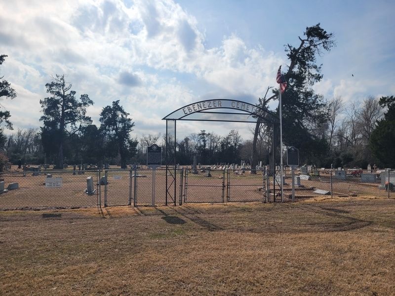
On Ebenezer Cemetery Rd (County Road 714) 1 mile south of State Highway 7, on the right when traveling south.
James A. Head was a Texas Ranger, veteran of the War for Independence, and Republic of Texas legislator. Born in Georgia in 1797, he moved to Texas in 1835, enlisting at San Felipe de Austin in Silas Parker's ranging company and securing a land . . . — — Map (db m293422) HM
On West State Street at Ellis Street, on the right when traveling east on West State Street.
Following the American Civil War and emancipation of slaves in 1865, it was not until 1871 that African Americans in Texas were able to uniformly register to vote, following the ratification of the 15th Amendment to the U.S. Constitution. . . . — — Map (db m304441) HM
A native of Georgia, Isaac Parker came to Texas in 1833 as part of the pioneer family that built Ft. Parker in Limestone County. He fought in the Texas Revolution and served in the Republic of Texas Congress, representing part of East Texas. He . . . — — Map (db m270606) HM
On South Micheaux Street, on the right when traveling north.
Roy B. Wallace was born in Coolidge, Limestone County, on October 13, 1901, to Benjamin C. Wallace, Sr. And Mae McCoy Wallace. Roy attended school in rural Limestone County and attended Texas Christian University prior to earning his Bachelor’s . . . — — Map (db m128979) HM
On State Highway 14 0.5 miles north of County Highway 662, on the right when traveling north.
The Brown Family Cemetery traces its origin to the settlement of North Carolina native Ervin Brown (1801 1875) and his wife Matilda (1807-1871) in Washington County, Texas. In 1846, Ervin and Matilda moved their family to a 1600 - acre farm, in . . . — — Map (db m159060) HM
Near Creek Drive west of Route 792, on the left when traveling west.
A Republic of Texas soldier during War for Independence. Born in Edgefield, S. C.; came to Texas in 1835. Entering army, he fought in famed victory of San Jacinto, April 21, 1836. He received headright and bounty lands in Brazoria, San Patricio, . . . — — Map (db m173108) HM
On State Highway 7 0.1 miles east of Ebenezer Church Road (County Highway 462), on the right when traveling east.
Limestone County historically supported numerous pottery producing kilns. This industry succeeded near area outcroppings of kaolin, or potter's clay within the Wilcox geologic formation. Alberry Johnson began the first county pottery in 1859 near . . . — — Map (db m201961) HM
On LCR Comanche A 0.1 miles south of Farm to Market Road 3437, on the right when traveling south.
Set aside by deed in 1898 as a permanent site for celebrating June 19th - the Anniversary of the 1865 Emancipation of slaves in Texas. It was 2.5 miles south of this site that slaves of this area first heard their freedom announced.
Limestone . . . — — Map (db m161560) HM
On Faulkenberry Road 0.1 miles south of E Yeagua Street, on the left when traveling south.
David Faulkenberry, believed to have been born in South Carolina circa 1795, wed Nancy Douthit in 1814 in Tennessee. The couple had seven children. The family was part of Daniel Parker's Pilgrim Church, an Illinois congregation that came to Texas in . . . — — Map (db m293414) HM
On East Palestine Avenue (State Highway 19) at North Laura Street, on the right when traveling east on East Palestine Avenue.
Native American photographer, artist and writer Osjetea Briggs was born on December 14, 1917, to Simeon Singleton Briggs (1877-1974) and Docia Augusta (Gant) Briggs (1894-1969) in Groesbeck, Limestone County, Texas. Following her high school . . . — — Map (db m186131) HM
On County Road 666 2 miles north of County Road 668, on the right when traveling west.
What is known as Bassett Farms encompasses nearly 2,500 acres of land in Limestone and Falls counties. The 1875 Bassett House and surrounding Bassett Home Place tract represent the core of the property, retained in family hands for over one hundred . . . — — Map (db m293480) HM
On Allyn Avenue (Farm to Market Road 339) at North Fourth Street West, on the left when traveling west on Allyn Avenue.
According to local tradition this congregation began in Mt. Calm, Limestone County, Texas, in the 1850s. By 1862 circuit preacher Andrew Davis held services in a schoolroom in the Mt. Calm Masonic Lodge. In 1883 the church erected a sanctuary here . . . — — Map (db m161649) HM
On East Washington Street (State Highway 7) at S Narcissus Street, on the left when traveling west on East Washington Street.
By 1861, the Houston & Texas Central Railway (H&TC) extended from Houston to Millican, a distance of 81 miles, but construction was halted during the Civil War. After the war, extension of this important transportation and commerce corridor . . . — — Map (db m293478) HM
On County Road 740 0.1 miles west of County Road 741.
Joseph and Hannah (Penrod) Ferguson moved to this area in the 1830s, years before the formation of Limestone County following Texas statehood. Their property, known as Ferguson Prairie, stretched from south of the early Box Church community to . . . — — Map (db m293344) HM
On North Ellis Street (State Highway 14) at West Sabine Street, on the right when traveling north on North Ellis Street.
When Groesbeck was founded in 1871, on Houston & Texas Central Railroad, Old Springfield (5 mi. NW) was bypassed. Some Baptists from the church founded there in 1846 moved here. Visited by William Carey Crane, J.B. Link, Z.N. Morrell and other . . . — — Map (db m164699) HM
On Ellis Street (State Highway 14) at West State Street, on the right when traveling north on Ellis Street.
A state representative, 1885-1886; Speaker of the House, 1885-1886. President of Texas A. & M., 1898-1901. Appointed by Gov. James S. Hogg to newly-formed commission, created to regulate shipping rates and practices. In his term, 1891-1895, . . . — — Map (db m164694) HM
On State Highway 7 at Ebenezer Church Road (County Highway 462), on the right when traveling east on State Highway 7.
Bardin King (1819-1891) and Elizabeth Susan Salter (1822-1879) married in Lowndes County, Alabama in 1842. The following year, they traveled west by wagon with their young son William and Susan’s parents and siblings, settling in Louisiana. Bardin . . . — — Map (db m156969) HM
Near Park Road 35 0.2 miles north of County Highway 401.
Built 1834 for protection from Indians. Named for leaders who brought First Predestinarian Baptist Church body to Texas. Elder Daniel Parker, his father, Elder John, brothers Jas. W., Benjamin, Silas, John. Also here were Kellogg, Frost, Nixon, . . . — — Map (db m166812) HM WM
On West State Street at Ellis Street (State Highway 14), on the right when traveling north on West State Street.
Limestone County was established in 1846. Springfield served as the first county seat, but geographic boundary changes and the burning of the Springfield Courthouse led to the designation of Groesbeck as the county seat in December 1873. Three . . . — — Map (db m164697) HM
On State Highway 14 at County Highway 456, on the right when traveling south on State Highway 14.
Named for the large spring on townsite donated Jan. 6, 1838, by Moses Herrin, who gave 4 lots to any person agreeing to settle in the town. 12 families later in 1838 were forced out by Indian hostility. Post office was established in 1846. When . . . — — Map (db m159046) HM
On Park Road 28 0.5 miles west of State Highway 14, on the left when traveling west.
Established as a 10-acre community burial ground in town plat dedicated Jan. 6, 1838, by Moses Herrin. Earliest graves probably never had stone markers because of primitive frontier living conditions. It is recorded that 12 families were driven . . . — — Map (db m161494) HM
On East Main Street at South McKinney State, on the left when traveling east on East Main Street.
Military officer and promoter of Texas Colonization. Served as Secretary of Mexican Legation to United States, 1829-1831. Led victorious Mexia Expedition to expel Centralists in Matamoros. 1832. Mexican senator, 1833-1834; he first supported . . . — — Map (db m159045) HM
Near Boonville Road 0.1 miles east of Austins Colony Parkway.
Eli Seale 1793-1857
Elias (Eli) Seale was born in North Carolina in 1793. He served as a fifer in the War of 1812 in Mississippi, and in 1835 moved with his three brothers and his family from Alabama to Texas. He received his Mexican . . . — — Map (db m170484) HM
Near Landa Park Drive (California Blvd) at Monument Drive.
1700 This tree began as a seedling in this major campsite of Central Texas Indians. Archeology has traced the Indians presence here to 13,000 years ago. Early settlers told that Indians left messages to those who followed by weighing down the . . . — — Map (db m168470) HM
On County Highway 231 1.1 miles east of Highway 246, on the left when traveling east.
After being captured by Comanche Indians on May 19, 1836, in what is now Limestone County, Cynthia Ann Parker was recaptured here by Texas Rangers under Captain L.S. Ross on December 18, 1860 — — Map (db m170422) HM
On County Road 1140 at County Road 1131, on the right when traveling north on County Road 1140.
Settlement of this community began in the 1850s, about the time the Texas Legislature created Freestone County out of Limestone County. Early settlers included the Smith, Claypool, Henderson, Wooldridge, Kennedy, Lemmon, Manahan, Cannon, Carroll, . . . — — Map (db m294830) HM
Near Fort Park Memorial Cemetery Road 0.4 miles east of Farm to Market Road 1245.
Daughter of local pioneers, Mr. and Mrs. J. Cull Sanders, and graduate of Kidd - Key College. Married C.D. Kelly in 1910. A Groesbeck Club Woman; served as treasurer, Texas Federation of Women's Clubs, when State Headquarters were being built in . . . — — Map (db m159055) HM
Settlers began arriving in this part of Limestone County in the 1850s. Soon Mount Calm community developed with a Masonic Lodge, stores, post office, school, and churches. James Samuel Kimmel, a pioneer settler, donated land for this cemetery, and . . . — — Map (db m161655) HM
On Lentzville Road 0.7 miles south of Barker Road, on the right when traveling south.
Lentzville Cemetery began as the family cemetery for the family of John Henry Lentz (7 Feb 1753-18 Jul 1835) and his wife Savilla. John Henry was a veteran of the American Revolution and pioneer settler of Limestone County, entering his land in . . . — — Map (db m114306) HM
On Parker Street at S 1st Street, on the right when traveling west on Parker Street.
Following the Civil War, many emancipated African Americans in Texas joined the African Methodist Episcopal Church. In Limestone County, churches organized at Comanche Crossing, Sandy, Rocky Crossing and Springfield. Allen Chapel A.M.E. Church began . . . — — Map (db m293392) HM
On County Road 186 at County Road 185 on County Road 186.
Established in 1878, this burial ground served the former community of Armour. The cemetery is located on property deeded by community founder, James Armour (d. 1896). For school, church and burial purposes. James Armour was born in 1825 in Jackson . . . — — Map (db m92125) HM
On Fort Park Memorial Cemetery Road 0.4 miles east of Farm to Market Road 1245, on the right when traveling east.
Site of the grave of victims of the massacre at Fort Parker by Comanche and Kiowa Indians on May 19, 1836, in which Cynthia Ann Parker and others were captured.
The trunk of the oak tree under which they were buried still stands, and the grave . . . — — Map (db m159048) HM
On County Road 454 0.5 miles north of County Road 453, on the right when traveling north.
Luther Thomas Martin Plummer and his wife Rachel (Parker) arrived in what is now Limestone County in 1834. They received a Mexican land grant for 3,321 acres in this area the next year. In 1836, Rachel, her son James, and her cousin Cynthia Ann . . . — — Map (db m293413) HM
On Ebenezer Cemetery Rd (County Road 714) 1 mile south of State Highway 7, on the right when traveling south.
The Ebenezer Baptist Church was organized in 1865 to serve the Head's Prairie and Headsville communities. Delegates to the Trinity Baptist Association meeting that year were J. R. Bullard, William Samuel Clark, and Thomas Seale Head, with the Rev. . . . — — Map (db m293423) HM
On Farm to Market Road 2705 at County Highway 477, on the left when traveling north on Highway 2705.
Established 1889, in era when Texas looked to Civil War Veterans for State Leadership. One of numerous parks on river banks or other favored sites that drew large, popular annual encampments. Statesmen came to make speeches. There were orations by . . . — — Map (db m161557) HM
On LCR 141 0.1 miles east of Farm to Market Road 73, on the left when traveling east.
This congregation was organized on October 18, 1885, with 12 charter members from the Mount Antioch Baptist Church assisting with the organization and ordination of deacons was Ezekial Jackson Billington (1826-1896), who had been ordained as a . . . — — Map (db m161584) HM
Near County Road 226 north of Westminser Street, on the right when traveling north.
One of armed men who helped seat 14th State Legislature in 1873 when incumbent Gov. E.J. Davis contested Richard Coke's election.
A member of the Confederate army, he fought throughout the Civil War in Ross' brigade.
Became Limestone . . . — — Map (db m292072) HM
On State Highway 171 0.3 miles east of Paris Road (County Route 178), on the right when traveling west.
In 1854, Ten Labors of Land (1770 acres) were surveyed in Limestone County for Jonathan Scott. In 1872, Henry Martin Munger moved his family from Rutersville (Fayette Co.) to Mexia. There he opened a lumberyard, planing mill, flour mill, grist mill . . . — — Map (db m92941) HM
Near Park Road 35 0.2 miles north of County Highway 401.
The stockade-blockhouse fortress that you see here today is a replica of the original fort built in 1834 by eight or nine Illinois families who had come to the Mexican state of Texas in 1832 and 1833. This structure, architecturally, is typical of . . . — — Map (db m186722) HM
On State Highway 171 0.1 miles east of County Road 634, on the right when traveling west.
Agricultural genius, born in Ruelzheim, Rhenish Bavaria, of a family of horticulturists. Educated in Germany. Migrated to New York in 1871 and to Texas 1876. In Limestone County (surrounding this marker site) lay 100 acres of open prairie land which . . . — — Map (db m292086) HM
On Farm to Market Road 339 0.2 miles south of LCR 131, on the left when traveling north.
In 1854, Ezekiel J. Billington came to this area of Texas from Kentucky with his wife, Kitty Ann and their three children. Billington organized a Baptist Church the following year and named it Mt. Antioch. The six charter members of the Mt. . . . — — Map (db m161648) HM
On County Road 4350 north of County Road 4336, on the right when traveling north.
In the late 1850s the Ralph Hunter League in eastern Henderson County was divided among David O. Warren's heirs and settlement of this area began in earnest. According to local history, John Dickey Morrison (1830-1896), though not an ordained . . . — — Map (db m269072) HM
On Farm to Market Road 1246 at County Road 758, on the left when traveling east on Road 1246.
The fine white clay mined near here was used at this shop from the 1840's to 1912 to make pitchers, jars, crocks, churns, flower pots, and ornamental urns, which were used locally and shipped out of county.
In the 1870's the shop, built by . . . — — Map (db m293343) HM
On Trinity Circle north of Browns Ferry Street (County Road 29), on the left when traveling north.
“Trinity School founder Mary Fletcher Wells
and the American Missionary Association
forged the path for reconstruction in Limestone
County's African American population in an
approach based on the belief that education
and religion . . . — — Map (db m158194) HM
Thin black lines indicate changes in relevance. Between each pair of lines entries are ordered geographically but all have the same relevance.
* Inflectional forms of words are their plurals, singulars, and possessives as well as gramatical tenses and similar variations.