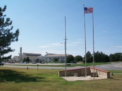
On Andover Road at 1st Street, on the right when traveling north on Andover Road.
Dedicated to the memory of
those who lost their lives
in the tornado of April 26, 1991,
and those who volunteered
their services in the
reconstruction effort
—————————
Gladys . . . — — Map (db m79200) HM
On State Street south of 4th Avenue, on the right when traveling south.
This log cabin housed the store of C.N. James, Post Office, Masonic Lodge, Baptist and Methodist Services and Public School taught by L.N. Blood.
Restored 1941-1967-1993
by Augusta Historical Society — — Map (db m79202) HM
On SE 116th Terrace at SE Main Street, on the left when traveling west on SE 116th Terrace.
The 1885 Frisco Wooden Water Tower was built to service the steam locomotives, supply water for feeding stationary boilers, washing cars, and floors, cleaning out boilers, cooling ashes, fire protection, and similar purposes, at shops, engine . . . — — Map (db m60686) HM
On SE 116th Terrace at SE Main Street, on the left when traveling west on SE 116th Terrace.
In 1879, Beaumont was established as a railroad town. It became one of the most important shipping points in the Flint Hills. Beaumont sat atop the divide that separated Otter Creek and Little Walnut Creek. Westbound trains from Piedmont had nearly . . . — — Map (db m60684) HM
On SE 116th Terrace south of SE Main Street, on the right when traveling east.
The Flint Hills of Kansas are the last remnant of the great Tallgrass Prairie that once stretched from Texas to the Great Lakes. The calcium rich soil of the Flint Hills is renowned for its capacity to quickly fatten cattle in the spring. Beaumont, . . . — — Map (db m60721) HM
On SE Main Street at SE 116th Terrace, on the left when traveling south on SE Main Street.
Local lore has it that in 1948 a Wichita businessman wanted to fly into Beaumont to check on his cattle. He asked the hotel if they would block the road for his landing. Since having a plane land in Beaumont was exciting, the residents agreed. . . . — — Map (db m60717) HM
These Frisco Ponds were developed in 1885 along with the now historic wooden water tower. The water was used to fuel the steam locomotives traveling west bound on the Frisco Line that had used all their water pulling the steep grade from Piedmont, . . . — — Map (db m60735) HM
On SE Main Street north of SE 116th Terrace, on the right when traveling south.
The Historic Beaumont Hotel (Side A)
The Historic Beaumont Hotel was built in 1879 by Edwin Russell. In 1885 the hotel was purchased by the Durham Cattle Company; in 1895 Durham sold the hotel to Reed Church. In 1910, when Charles Church . . . — — Map (db m60623) HM
Brig. Gen. - U.S. Volunteers
Commander [Mississippi] Marine Brigade
Capt. 59th Ill. Inf. Aug. 20, 1861
Lieut. Col. U.S. Volunteers Apr. 28, 1862
Brig. Gen. Nov. 1, 1862
This marker erected in 1979
at the request of his grandson,
the . . . — — Map (db m56037) WM
This is the type of rig used in the 19 teens and into the 1930's during the oil boom in Kansas. Three main sections make up the early rigs: the boiler which was the energy source to power the steam engine that ran the rig; the derrick which was . . . — — Map (db m56040) HM
On Central Avenue near Gordy Street, on the left when traveling west.
To Honor Those Who Serve
Liberty For All
[Representative Memorials]
In honor of George F. Austin
for service in the Navy aboard
USS Estes AGC 12
Flag Ship supporting the invasions of
Iwo Jima and Okinawa
witnessing the flag . . . — — Map (db m56220) WM
From the former Midland Refinery. Used to burn off gasses as gasoline and propane were transferred from the refinery into the railroad tank cars. ca. 1920's
Donated by: Frontier Refinery — — Map (db m56165) HM
This house was built in 1918 at 800½ South Main Street, El Dorado, Kansas, (Gordon's Addition, Lot 5, Block 4) in direct response to the oil boom and the massive amounts of people moving to the area looking for housing. Originally the home was . . . — — Map (db m56166) HM
George W. Brown drilled Kansas' first oil well in 1860. Since that time, Kansas oilmen have tested their courage, their fortunes, and their luck in the search for oil in all parts of the state. The Kansas Oil Museum is dedicated to the men and women . . . — — Map (db m56039) HM
This is a Model K Star Drilling Machine, also called a "spudder".
Drilling machines such as this one were used for two purposes:
1. To drill the initial hole for a rotary-drilled well.
2. To drill a complete oil well at shallow depth . . . — — Map (db m56125) HM
In honor of
Mrs. Addie Cowley Bradley
who was the first white girl born
in Eldorado Township;
the first in Butler County;
the first in the Fifth District of Kansas.
Born May 4, 1858. Died Feb. 27, 1932.
Boulder furnished by . . . — — Map (db m56038) HM
Oil field towns such as Oil Hill and Midian were built and maintained by oil companies such as Cities Service. These towns were fast growing and held an excitment in the early years when people moved in at all hours of the day and night. Life here . . . — — Map (db m56168) HM
Once the oil boom began in 1915, men and their families flooded the El Dorado area to find work in the oil fields. Small 2 to 5 room houses were built by the oil companies on land that was leased - thus the lease house or company house. By living . . . — — Map (db m56092) HM
Manufactured by the Spencer Trailer Company in Augusta, Kansas. This was used to haul tubing (the narrow pipe located on the trailer) or casing (wider pipe). Tubing and casing is the various pipe that is used inside the hole.
Donated by: Harvey . . . — — Map (db m56127) HM
On Central Avenue (State Highway 254) at Star Street, on the left when traveling west on Central Avenue.
With the faith and courage of
their forefathers who made
possible the freedom of these
United States
The Boy Scouts of America
dedicate this replica of the
Statue of Liberty as a pledge
of everlasting fidelity and
loyalty . . . — — Map (db m56179) HM
On Central Avenue (State Highway 254) near Gordy Street, on the left when traveling west.
Our Freedom Began When in 1776
These Courageous Men Signed
The Declaration of Independence
Father of Our County
George Washington
The Voice of Freedom
Patrick Henry
The Pen of Freedom
George Mason
[Signers of the . . . — — Map (db m56184) HM
This machine was probably manufacturing in Chanute, Kansas in the late 1920's. It had been used in Eastern Kansas from the 1920's through the 1950's. This machine was highly portable when completely assembled and moved easily by horses and a . . . — — Map (db m56128) HM
This derrick is one of the last wood and steel oil derricks which once dotted the Butler County countryside. It was built in the mid-1940's and is 100 feet high.
Donated by: Larry Crawford
Donors: Joe Degan Pipe & Supply, Albert Hogoboom, . . . — — Map (db m56088) HM
Central power units were used to pump oil wells in the early days of the Kansas oilfields. One central power could pump as many as eighteen different wells, some up to half a mile away. In the 1950s producers began to replace central powers with . . . — — Map (db m56130) HM
This Cable Tool Drilling Machine, Serial No. 5, was manufactured in Chanute, Kansas by Sutcliffe Pipe & Supply, Joe H. Sutcliffe, owner. Built in early 1949, this is the only known remaining machine.
"The Gypsy" was found on a farm east of . . . — — Map (db m56133) HM
Rack contains various cable tool bits such as fishing tools, jars, rope sockets and elevators. These pieces were used with the adjoining cable tool rig. Many of these pieces of equipment were stored at yards and tool houses. — — Map (db m56090) HM
This railroad tank car has a capacity of 9913 gallons and was built in April of 1929. Used to haul raw crude oil to the refinery.
Donated by: Union Tank Car Company — — Map (db m56163) HM
On Central Avenue (State Highway 254) near Gordy Street, on the left when traveling west.
This staff dedicated to the Veterans of all United States wars who valorously defended the flag it bears
Stars & Stripes waving here perpetually provided by Fred Priestley Post 1174 Veterans of Foreign Wars
Constructed May 1953
Board . . . — — Map (db m56182) WM
On Main Street (U.S. 54) at Vine Street, on the right when traveling east on Main Street.
Dedicated to the memory of
William Allen White
Boyhood resident
of El Dorado
who became
Kansas' foremost editor
On his one hundredth
birthday anniversary
February 10, 1968 — — Map (db m40003) HM
The town and township lie tucked in the pleasant valley of the Whitewater River, and take their name from the Osage Indian term "many waters." First settler was C.L. Chandler, a returning '49er from the California gold fields who built his cabin . . . — — Map (db m304354) HM
On Summit Street (U.S. 77) north of Maple Avenue, on the left when traveling north.
May 18, 1996
Torch Bearers
Charles Dow, Local Community Hero
Emily Bergkamp • Michael Goff
Amanda Crouse • Shaunta Lolar
Greg Gann • Trisha Morgan
Jenny Graham • Brooke Snowden
Nick Gilliland • Chad Taylor
100th Anniversary of the . . . — — Map (db m60510) HM
Near U.S. 77 near 312th Road, on the right when traveling south.
The Cherokee Outlet or Strip south of here was opened to a land rush in 1893. This tract of land was 60 miles wide and stretched along the Kansas-Oklahoma border. Due to a surveying error, a two-mile strip lay north of the Kansas border. The land . . . — — Map (db m304696) HM
On Summit Street (U.S. 77) south of Birch Avenue, on the left when traveling north.
"Robert Docking was a constant -- a man with Kansas qualities: plain spoken, affable, optimistic, strongly loyal and committed to family, friendship, community and public service. Enduring qualities."
Governor of the State of Kansas 1967 to . . . — — Map (db m60511) HM
On Summit Street (U.S. 77) north of Maple Avenue, on the left when traveling north.
Engine 2542 was built in 1910 by the American Locomotive Company in Pittsburgh, PA., for the Kansas City, Mexico and Orient Railway. In 1929, the Atchison, Topeka and Santa Fe Railway purchased the KCM & O Line and assigned this engine to the . . . — — Map (db m60487) HM
On 312th Street at U.S. 77, on the left when traveling west on 312th Street.
Dedicated to
the many thousands who pioneered
The Cherokee Strip
September 16, 1893
Thousands gathered in this area to start a
new frontier, six million acres of Cherokee
Indian land was opened to homesteaders.
Tension, danger . . . — — Map (db m60486) HM
On U.S. 166 at Kansas Highway 15, on the right when traveling east on U.S. 166.
Natural gas in this locality was first found in 1903 at Dexter, five miles north. The town, envisioning a prosperous future, advertised its discovery far and wide. Crowds gathered to see the well fired, then watched in dismay as the roaring gas . . . — — Map (db m304693) HM
On Main Street (U.S. 77) south of 8th Avenue, on the right when traveling north.
Owners
S. H. Jennings: 1901-1918
F. M. Benson: 1918-1920
Andrew Wilson: 1920-1941
E. H. Ruppelius: 1941-1974
Dorothy Fisher: 1974-1978
Joseph & Elizabeth Sears: 1978-1994
Elizabeth Sears Trust: 1994-
Occupants
Unknown: . . . — — Map (db m60528) HM
On Main Street (U.S. 77) at 9th Avenue (U.S. 160), on the left when traveling north on Main Street.
This corner marks the spot where in 1869 Colonel E. C. Manning placed the stake from which the City of Winfield was laid out. The first building in Winfield, Colonel Winfield's old log store, stood on this corner. In 1885, Henry Goldsmith . . . — — Map (db m60527) HM
Near College Street at East 1st Avenue, on the right when traveling north.
*Barr, Allan USMC • Bartlett, Gary USA • Bistok, Joe USA • *Bradford, Allen USA • Brass, Steve USMC • Brooks, Michael USA • Bugbee, Rod USA • Clinton, Dewitt USA • Dial, Craig USA • Dial, Keith USA • Duckworth, Bill USMC • Filbert, Charles USA • . . . — — Map (db m229892) WM
On Main Street at 3rd Street, on the left when traveling south on Main Street.
This building is the
gift of Andrew Carnegie
to the People of Halstead
A.D. 1917
———————————
In honor of all the volunteers
who helped during the
1993 Floods in . . . — — Map (db m81283) HM
Dedicated
to the Soldiers
who so bravely offered
their all to preserve
the Union of States,
1861 to 1865
Decorated
in memory of our comrades
who sleep in the
Unknown,
peacefully awaiting the
call to the Parade . . . — — Map (db m77110) WM
On 1st Street east of Main Street (Kansas Highway 89), on the left when traveling east.
Trees and plaque donated by World War II Buddies of 310th Inf. 78th (Lightning) Div. Co. I, the Steele Family, and Many Friends. — — Map (db m81270) WM
On Locust Street at 4th Street, on the left when traveling north on Locust Street.
Originally owned by the Halstead Town Company, Block 28 was officially designated a city park by the City of Halstead in 1891.
The Scout Cabin was built for the Halstead scout groups in 1941 by the Halstead Lions Club with the generous support . . . — — Map (db m76937) HM
On Main Street at 2nd Street, on the right when traveling south on Main Street.
Site of the first public building in Halstead, Kansas
Erected in March 1873 by G. W. Sweezy
It was a two story frame building 32 feet by 42 feet used as a commercial hotel and known as
The Sweezy Hotel
After fifty nine years of use, the . . . — — Map (db m81281) HM
On Hertzler Road (Horse and Buggy Doctor Highway) (State Highway 89) south of U.S. 50, on the left when traveling south.
"The Great American Home is that institution in which it is possible for the child to grow to maturity under conditions created and maintained for the good of the child."
Dr. Arthur E. Hertzler
Dr. Arthur E. Hertzler
1870 - . . . — — Map (db m81267) HM
On Main Street south of 2nd Street, on the left when traveling south.
This stone building was erected in 1879 after a disastrous fire wiped out many frame buildings on Main Street. Bergtholdt had a farm implement agency in the south section until 1885. That year Henry Riesen and David Dyck opened a hardware store. . . . — — Map (db m81279) HM
On Main Street (State Highway 89) at 1st Street, on the right when traveling north on Main Street.
In Memoriam
World War II
Carl F. Dill • Claude H. Beaty • Marlin N. Wilson
Wilbur D. Robuck • Charles C. Spore • Vernon H. Buller
Marvin E. Lohmeyer • Leland F. Wendling
Elmer E. Rodenberg • William Hoffman Jr.
Orville D. Bansemer • . . . — — Map (db m81268) WM
On Kansas Route 15 0.8 miles north of NE 96th Street, on the left when traveling north.
Beaten hard by the hoofs of millions of Longhorns coming from as far as southern Texas between the years of 1867 to 1871 this trail wound northward approximately one half mile east of here. In one year alone over 600,000 cattle were herded north . . . — — Map (db m61102) HM
On North Main Street at East Smith Street, on the right when traveling north on North Main Street.
In the 1870s this area was settled by people with diverse backgrounds who shared the promise of the land. With an influx of those of Mennonite faith and the railroad's birth in the 1880s, success of the town was very likely. Hesston's name honors . . . — — Map (db m170407) HM
On North Main Street at East Smith Street, on the right when traveling north on North Main Street.
Plaque on front of building at 100 N. Main St. This is the oldest building still standing in the business row on Main Street. It was built in 1887 just after the town was officially organized. This building housed the first post office in . . . — — Map (db m170410) HM
On Main Street at 5th Street, on the right when traveling north on Main Street.
Santa Fe engineers were surveying and platting the Newton town site on Section 17 in March 1871. Captain David L. Payne, state legislator from this district, and other early settlers saw the urgent need for domestic drinking water. Captain Payne . . . — — Map (db m56891) HM
On North Main Street (State Highway 15) at West Broadway Street, on the left when traveling north on North Main Street.
Five generations of the Anderson family have operated Newton's oldest retail business for over 100 years on Main Street. Founder Phillip Murray Anderson began his business in 1892 selling newspapers on Santa Fe trains. In 1894 he opened a newsstand . . . — — Map (db m166282) HM
On 1st Street near Oak Street, on the right when traveling east.
This Victorian house was built for Bernhard and Wilhelmina Warkentin in 1886-87. Bernhard was born in 1847 in the Mennonite village of Altonau, Ukraine. His father was a prominent miller. In 1872 he came to the U.S. to find new land. His letters . . . — — Map (db m56848) HM
On Oak Street at Broadway, on the right when traveling north on Oak Street.
This cannon used in coastal defense during the Civil War was secured through the efforts of Judson Kilpatrick st No. 36, G.A.R. and Congressman Chester I. Long. Presented to Mayor George W. Young for City of Newton by Hon. J. G. Wood, Topeka, on . . . — — Map (db m56919) HM WM
On North Main Street (State Highway 15) at East 7th Street, on the right when traveling north on North Main Street.
Twenty persons met in a vacant store on the east side of Main, midway between Sixth and Broadway, on July 7, 1872 to hear a sermon and to organize one of Newton's oldest Protestant churches. On March 25, 1875 the cornerstone was laid for a new . . . — — Map (db m166220) HM
On East 6th Street at North Oak Street, on the left when traveling east on East 6th Street.
In 1879 John Jacob Krehbiel (1838-1921), his wife Anna Leisy Krehbiel (1845-1923) and their children came to Newton from Denmark, Iowa. With George L. Epps, he purchased the Angood Blacksmith Shop at 128 E. 6th. In 1883 Krehbiel bought the business . . . — — Map (db m166406) HM
On Athletic Park Drive 0.1 miles north of Fischer Field (football stadium), on the right when traveling west.
The "Mennonite Settler," designed and sculpted by artist Max Nixon (1915-2000), was dedicated by the City of Newton September 10, 1942. Funding came from citizens of Newton, the Junior Chamber of Commerce, and the U.S. Works Progress Administration . . . — — Map (db m53494) HM
On North Main Street (Kansas Route 15) at West 6th Street, on the left when traveling north on North Main Street.
Midland National Bank opened March 3, 1893 in a building located on the northeast corner of Fifth and Main. Grant Hornaday was the bank's president, J.H. McNair, vice-president and Don Kinney, cashier. The bank purchased this site in 1896 for $6000 . . . — — Map (db m166216) HM
On Main Street (State Highway 15) at 2nd Street, on the left when traveling north on Main Street.
On April 15, 1903 construction began on this site. The Cottonwood stone, red brick facade and Ionic columns combined to provide a striking addition to Main Street Newton. The two story building was designed by W.W. Rose, and constructed by Reikowski . . . — — Map (db m56851) HM
On Second Street West at Old Mill Road, on the left when traveling west on Second Street West.
By the summer of 1871, men laying track for the Santa Fe railroad
established a railhead at the new boomtown of Newton. It became the
loading point for Texas longhorns coming north on the Chisholm Trail,
replacing Abilene, Kansas. Newton's . . . — — Map (db m250171) HM
On North Main Street (State Highway 15) at West Broadway Street, on the left when traveling north on North Main Street.
The Ragsdale Opera House served as Newton's main center of entertainment for nearly 30 years. The grand opening was held on December 8, 1885, featuring Barney McCauley in the comedy Uncle Dan. Under constructions since May 29, 1884, it was completed . . . — — Map (db m166215) HM
On Broadway at Oak Street, on the left when traveling east on Broadway.
Donated to the City of Newton by the Santa Fe Nov. 18, 1955. Engine 1880 and 86 other Prairie type engines built in 1906-1907 by the Baldwin Locomotive Works. They were used in various types of service for 46 years which was a longer period of . . . — — Map (db m56922) HM
On North Main Street (State Highway 15) at East 8th Street, on the right when traveling north on North Main Street.
The first Harvey County Courthouse on this site was a three story red brick structure in the modified Romanesque Revival style dominated by a tall clock tower. Bedford stone highlighted the exterior with marble lining the interior hallways. J.C. . . . — — Map (db m166218) HM
On East Broadway Street at North Main Street (State Highway 15), on the right when traveling east on East Broadway Street.
Masonic Lodge No. 142 was organized in 1873 with Samuel Saylor appointed master. The first meeting was held in the new schoolhouse using boxes for the altar and jewels made of tin. Early members included Muse, Peters, Munger, Spivey, Lynch, Neal, . . . — — Map (db m166283) HM
On Interstate 135 1 mile north of 125th Street (I-135 Exit 22) (Interstate 135), on the right when traveling north.
On 13 May 2003, Kansas Governor Kathleen Sebelius, proclaimed the Eisenhower Interstate Highway System in Kansas, as the "Purple Heart Trail." This trail memorializes those heroic service members who have had the Purple Heart medal bestowed on them . . . — — Map (db m56916) HM WM
Children in Russia hand-picked the first seeds of this famous winter wheat for Kansas. They belonged to Mennonite Colonies preparing to emigrate from the steppes to the America prairies. A peace-loving sect, originally from Holland, the . . . — — Map (db m53056) HM
On West Washington Street at North River Street on West Washington Street.
In 1871, Dr. Henry Clay Tucker arrived in this area from Ohio and began practicing medicine. With no bridge across the Arkansas River, he often swam across to tend to patients west of the river.
In 1873, an influx of people to El Paso, Kansas . . . — — Map (db m253096) HM
On East Market Street east of North Westview Street, on the left when traveling east.
In March 1924, this red brick building opened as the third school at this site. It had 10 classrooms, study hall, small office, two modern lavatories and a gymnasium/auditorium. From 1924 to 1953, this was the only public school in town; high school . . . — — Map (db m253108) HM
On North Baltimore Avenue at West Main Street, on the right when traveling south on North Baltimore Avenue.
On July 11, 1871, J. Hout Minnich and John Hufbauer filed a town plat for El Paso in Sedgwick County, Kansas. It established streets from Madison to Kay and from Water Street to Georgie Avenue, and business boomed.
Around the turn of the . . . — — Map (db m253103) HM
On South Woodlawn Boulevard 0.2 miles south of East Market Street, on the right when traveling south.
El Paso Cemetery sits on a slight hill in the center of Derby but was once surrounded by farmland and was about a mile southeast of the growing settlement. In 1878, the cemetery opened, 9 years after the Garrett family staked a claim near the bank . . . — — Map (db m253115) HM
On South Red Horse Drive 0.2 miles south of East Chet Smith Avenue, on the right when traveling south.
Alexander and Margaret (Dickson) Garrett were the first settlers to put down roots in what was first El Paso and was renamed Derby, Kansas. In 1869, the area was considered Indian Territory (Osage Trust Lands) and had many transient traders, . . . — — Map (db m253119) HM
On South Brookwood Drive south of East Redwood Road, on the left when traveling south.
In 1869, Fred Gerteis homesteaded this land. In 1900, he traveled back to Germany to get his 23-year-old nephew, Albert Lauber, to help work the land by promising the farm eventually would become his. After Albert Lauber returned to Germany to get . . . — — Map (db m253118) HM
On East Market Street west of North Woodward Boulevard, on the right when traveling west.
In 1899, this brass bell was mounted on the Atchison, Topeka and Santa Fe Steam Locomotive #419, which was manufactured in Scranton, Pennsylvania. The locomotive saw active service through the late 1930s along the railroad's main lines through . . . — — Map (db m253112) HM
On North Broadway Avenue south of 63rd Street, on the left when traveling north. Reported permanently removed.
In October 1865 hundreds of Plains Indians camped on these prairies to negotiate peace with U.S. government officials. Among them were Chiefs Black Kettle and Seven Bulls (Cheyennes), Little Raven and Big Mouth (Arapahos), Rising Sun and Horse's . . . — — Map (db m61099) HM
On North Broadway Avenue 0.2 miles north of West 61st Street North, on the left.
Hundreds of Cheyennes. Arapahos, Kiowas, Apaches,
and Comanches camped not far from here in 1865 to
negotiate peace with the U.S. government. Both sides at
the Little Arkansas council hoped their new treaties
would put an end to the hostilities. . . . — — Map (db m250037) HM
When the last red man has vanished from the earth, and his memory is only the shadow of a cloud moving across the prairie, these shores and forests will still hold the spirit of my People, for they love the earth as a newborn loves its mother's . . . — — Map (db m56748) HM
On Douglas Avenue at St. Francis Street, on the right when traveling east on Douglas Avenue.
This site, originally platted in December, 1870, dates back to Wichita's early development with the establishment of the Wichita & Southwestern Railroad, later absorbed by the Santa Fe System. The railroad was completed at Wichita in May, 1872 and . . . — — Map (db m60594) HM
Dedicated to the many veterans who sacrificed for the freedoms we enjoy today.
Flags have traditionally been symbols of persons united in some common association or effort. Within the American heritage, there have been many diverse interests and . . . — — Map (db m56932) HM WM
While the Plains Indians hunted many kinds of animals, their very existence depended on the buffalo. The massive creatures supplied most of the meat for their diet. Every part of the great animal was used. Nothing was wasted. From the buffalo they . . . — — Map (db m56808) HM
The pipe was central to tribal social and ceremonial life. A shared pipe sealed a friendship, a trade agreement, a treaty.
The solemn act of smoking a pipe was usually part of a group ritual or observance, such as in council, in which the pipe . . . — — Map (db m56789) HM
The Plains Indian chief was not an autocratic ruler. The title was honorary, although an exceptionally powerful personality could exert great influence. As a rule, any power exercised within the tribe was done so by the total body of responsible . . . — — Map (db m56790) HM
For the Plains Indian, the sacred hoop was the all-encompassing symbol of the entire world, with one half of the circle representing the physical realm, the other the spiritual. Equally significant was the number four. The four quadrants of the . . . — — Map (db m56749) HM
On Central Avenue near Main Street, on the left when traveling east.
Erected A.D. 1912 by the
People of Sedgwick County, Kansas
in memory of the
Union Soldiers and Sailors
of the Civil War
The Union is perpetual
Abraham Lincoln
Let us have peace
Gen. Grant
If any man attempts to
haul . . . — — Map (db m56422) WM
A beacon of light in the community since 1901, The Coleman Company has provided many products that bring together family and friends for lifelong outdoor memories. "Coleman Hill" is a living example of their commitment to Wichita.
Thank you . . . — — Map (db m56351) HM
245 entries matched your criteria. The first 100 are listed above. Next 100 ⊳