On Mitchell Lane at University Avenue on Mitchell Lane.
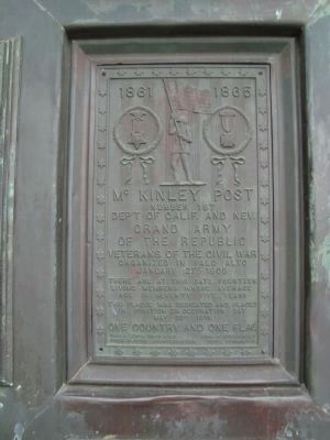
[Several veterans memorials are located at the base of the flagstaff in front of the Hostess House.]Side A:
1861 – 1865
McKinley Post
Number 187
Dept. of Calif. And Nev.
Grand Army
of the Republic
Veterans of . . . — — Map (db m174145) HM
On Monterey Road, on the right when traveling north.
The town of Coyote was established on a popular route known as El Camino Real by the Mexicans who traveled it. This route linked the missions throughout California. Originally named Burnett, Coyote developed around a post office that was housed in a . . . — — Map (db m207448) HM
Near East San Martin Avenue west of New Avenue, on the left when traveling east.
In the 1830s, most of what is now the park was located on the Rancho San Francisco de las Llagas granted to Carlos Castro. The reservoir is found on early public lands and also on the lesser Rancho La Polka granted to Isabel Ortega; her father, . . . — — Map (db m18528) HM
Near Bertram Way near Cinnabar Hills Road, on the right when traveling north.
Dating back to early 1850’s, this cemetery was in use until 1920’s, when musician Ben Black, who wrote the then popular song, “Moonlight and Roses”, bought some of the mining company land at the Hacienda and divided it.
Bertram Road . . . — — Map (db m12925) HM
Near Rincon Avenue near Dot Avenue, on the left when traveling west.
California used to be part of Spain and then Mexico. Vast ranchos were granted to worthy citizens. In 1840 Mexican Governor Juan Alvarado granted Rancho Rinconada de los Gatos (corner of the cougars) to brothers-in-law Sebastian Fabian Peralta and . . . — — Map (db m130197) HM
On Monterey Road (California Route 82) just north of Skyway Drive, on the right when traveling south.
The Northern California Black Walnut trees seen along this highway owe their existence to horticulturist Horace G. Keesling of San José. While passing this way by camp wagon on a blistering summer day in 1900, Keesling could find no roadside tree . . . — — Map (db m52138) HM
On San Felipe Road at Yerba Buena Avenue, on the right when traveling north on San Felipe Road.
Pioneer Evergreen settler Francis J. Smith built this home in 1874 on land originally part of the Chaboya Mexican Land Grant, Rancho Yerba Buena. The Village of Evergreen’s commercial center stood near this site, where in 1868, brothers Charles C. . . . — — Map (db m212756) HM
On Lincoln Avenue south of Sinclair Freeway ( Highway 280), on the left when traveling south.
This historic adobe was built in 1836 by a native Californian, Roberto Balermino, on Rancho de los Coches. The property was officially granted to him by Governor Micheltorna in 1844. A larger one-story dwelling was built in 1847 by the new owner, . . . — — Map (db m52119) HM
Large scale farming and ranching was needed to supply the restaurants and grocery stores in fast-growing cities like San Francisco and Los Angeles in the late 1800s.
Henry Miller and Charles Lux purchased large areas of land throughout . . . — — Map (db m25309) HM
Near Curie Drive east of Korhummel Way, on the right when traveling east.
This parcel, known as the Bernal Adobe Site, is part of the Rancho Santa Teresa Historic District of Santa Clara County. Ancestors of Mowekma Ohlone Indians used this area as a large permanent cemetery and village site as long ago as 3,000 years due . . . — — Map (db m52767) HM
Preserved here is equipment used in quicksilver mining. A few examples are from New Almaden, but most are from the Guadalupe Mine and were used in the last fifty years of mining, until the mines closed in the 1970s.
The equipment is organized . . . — — Map (db m49854) HM
On Vandegrift Boulevard, on the right when traveling south.
In July, 1769, the Portola Expedition named this area for St. Margaret of Antioch. The Mission San Luis Rey 1827 inventories list a small building in the area. In 1841, Rancho Santa Margarita y San Onofre was granted to Andres and Pio Pico, the last . . . — — Map (db m51107) HM
He is ranked among the representative citizens of Los Angeles County. He left Missouri in 1849 and settled in Santa Clara County. He came to Southern California in 1869 and purchased 325 acres of the old Dalton Tract, near El Monte. His family . . . — — Map (db m152637) HM
The Picchetti family built this winery in 1896, enabling them to produce their own wine. Before then, they had sold their grapes to other local wineries. Theresa Picchetti advised her husband, Vincenzo, to withdraw their savings, which totaled about . . . — — Map (db m203300) HM
On Pacheco Pass Highway (State Highway 152) 1.8 miles east of State Highway 101, on the right when traveling east.
This base is a two-sided monument commemorating both Rancho San Ysidro (side 1) and San Ysidro School (side 2)
Rancho San Ysidro
In the early 1800's Rancho San Ysidro was granted to Ygnacio Ortega. After his
death the lands were . . . — — Map (db m18484) HM
Hoeing tables and cleaning tanks were used to purify mercury as the final step in the process of converting cinnabar to mercury. Mercury collected in the condensers of a furnace or retort was contaminated with soot, water, dust, sublimed sulphur . . . — — Map (db m49857) HM
On Almaden Road at Bertram Way, on the left when traveling west on Almaden Road.
Here, along Arroyo de los Alamitos Creek in 1824, Luís Cabolla and Antonio Suñol first worked New Almaden ore in an arrastra. In constant production since 1845, more than a million flasks of quicksilver valued at over 50 million dollars have been . . . — — Map (db m18692) HM
Near West San Fernando Street west of South 1st Street.
On this corner stood the Garden City Bank Building, where Charles D. Herrold established Station FN, the first radio broadcasting station in the world. As a pioneer in wireless telephony (radio), Herrold established the first station in 1909 to . . . — — Map (db m30327) HM
On North 24th Street at East Julian Street, on the right when traveling south on North 24th Street.
Founded in 1863 during the Presidency of Abraham Lincoln, SJHS is the oldeest high school in Santa Clara County and second oldest in California. Its first classes were held in a 2nd floor room of J.G. Orbon’s flour store, where Joseph Bowen, the . . . — — Map (db m68915) HM
On Roosevelt Street, on the right when traveling east.
On March 29, 1849. Henry Chapman Skinner left Milwaukee, Wisconsin and crossed the plains to California, taking with him some Newtown Pippen Apples. Most of these apples decayed during the trip, but one was saved and contained thirteen seeds. In . . . — — Map (db m218883) HM
Near North Sunnyvale Avenue near East California Avenue.
Hendy Stamp Mill
During the California Gold Rush, Hendy Iron Works built mining and stamp mill machinery exclusively. They supplied mining operations around the world with 5-stamp mills that could operate as a single unit or as multiple units . . . — — Map (db m30251) HM
Near Lincoln Street near Bellomy Street, on the right when traveling north.
Secundino Robles
c. 1811-1890
María Antonia García
c. 1816-1896
Here lie a Don and Doña.
Proud Californios who shaped this region
under Spanish, Mexican, and United States governance. In 1824, at age thirteen, Secundino discovered an . . . — — Map (db m218886) HM
On Hope Street near Elizabeth Street, on the left when traveling north.
During Alviso’s years as a major shipping port, this warehouse was used for the storage of goods prior to shipping. It was later incorporated into Bayside Cannery and used as a cold storage and refrigeration plant. Today it stands as one of the . . . — — Map (db m24345) HM
Near Watsonville Road at Burchell Road, on the right when traveling west.
[This is a two-sided marker. Side-one being in English and Side-two being in Spanish:][Side One:]
CHITACTAC
For over 3,000 years, this area around the Uvas Creek drainage supported large populations of ancestral Ohlone People. . . . — — Map (db m18508) HM
Near Wessex Place north of North Park Victoria Drive.
Adobe house built by Jose Higuera about 1831 on Rancho Los Tularcitos
Marked by
San Jose de Guadalupe Chapter
Daughters of the American Colonists
August 1958 — — Map (db m211577) HM
The first workable quicksilver mine in North America – First mine of any kind in California – First worked 1824 – Denounced November 1845. Has produced more metallic wealth than any individual gold mine in California. Its . . . — — Map (db m146473) HM
On North 3rd Street north of Saint John Street, on the right when traveling north.
Local Scottish Rite Masons built their hall on this site in 1909. Designed by George Page, it was a simple rectangular structure with a severe Greek Revival façade. When the Masons moved into the new Scottish Rite Temple in 1925, the vacated . . . — — Map (db m30261) HM
On St. James Street just east of Terraine Street, on the left when traveling east.
Pellier, native of France, and founder of California's prune industry, came to California in 1849.
In October 1850 he established a nursery called
"City Gardens" on this site. Here, aided by his brothers Pierre and Jean, he introduced the . . . — — Map (db m154468) HM
The Santa Margarita Ranch House Bell. It is not known where the Santa Margarita Ranch House Bell was cast or in what year it was first hung in the arch on the front porch of the ranch house.
It has been suggested that it may have been brought . . . — — Map (db m117060) HM
You are standing in front of the old homestead house, the earliest building at Picchetti Ranch. Secundo Picchetti built this house in 1882. Soon after, he and his wife moved in and began clearing land for vineyards. In 1884, Secundo sold his half . . . — — Map (db m203299) HM
On West 3rd Street near Del Monte Avenue, on the right when traveling west.
Oak woodlands have become California’s signature landscape due to their widespread distribution and unique appearances. These woodlands provide critical wildlife habitat, scenic beauty, healthy watersheds, recreational opportunities, and a link to . . . — — Map (db m212712) HM
The nearby Bailey Fellows house is a historic “Italianate” structure located at the south end of Calero Reservoir and appears on the County of Santa Clara Heritage Resource Inventory. The house is named for Boargenes R. Bailey and Judge Edward . . . — — Map (db m53474) HM
Red Rock Riches
Cinnabar was highly valued as used for pigment by the Ohlone people who lived around Mount Umunhum. It contained mercury, also known as "quicksilver," which was essential for processing gold during California's Gold . . . — — Map (db m114618) HM
Beginning in the 1840s, the dock at Alviso served as Santa Clara County’s access to the San Francisco Bay. From this port, passengers boarded steamboats loaded with goods and produce bound for San Francisco and points beyond. In the early days of . . . — — Map (db m64389) HM
Marker One:
Rancho Ojo de Agua de la Coche granted to Juan Maria Hernandez
Marker Two:
1845
Rancho Ojo de Agua de la Coche conveyed to Murphy family — — Map (db m213068) HM
Overview of History
California Nursery Historical Park is 20 acres of prime agricultural land. People who inhabited the area included the Muwekma Ohlone, Spanish (Mission San Jose), Mexicans (Rancho Arroyo de la Alameda), and “Californios.” . . . — — Map (db m208723) HM
On Alma Street south of East Creek Drive when traveling east.
As the largest local watercourse, San Francisquito Creek played a major role in the lives of native Americans, Spanish explorers and early Anglo settlers of the area.
For perhaps 7,000 years, the native peoples -- called Costanos by . . . — — Map (db m113017) HM
[The Morgan Hill Centennial Project is a very unusual ‘marker’. It was created to celebrate the 100th anniversary of the incorporation of the City of Morgan Hill. One starts at the center of the marker and then proceeds along an expanding spiral . . . — — Map (db m46097) HM
On George Sellon Circle south of Palm Drive, on the right when traveling east.
Marker One:
For over a century, Agnews Hospital cared for those with mental illness and developmental disabilities. Established by an act of the legislature in 1885 as an asylum for the “insane,” its focus changed within a few years. When . . . — — Map (db m220572) HM
On Stage Road north of Pescadero Creek Road, on the left when traveling north.
Built in May 1867, this is the oldest church building on its original site within the San Mateo-Santa Clara County region. Its classical revival style reflects the cultural background of pioneer Yankee settlers of the South San Francisco . . . — — Map (db m141) HM
Near Manila Drive east of Camino Verde Drive, on the right when traveling east.
During the later 1800s, the developing Santa Clara Valley demanded an increase in farm products. California settlements needed wheat and produce to feed growing Gold Rush populations. When the Transcontinental Railroad of 1869 linked the valley to . . . — — Map (db m219207) HM
On Big Basin Way (Highway 9) near 3rd Street, on the right when traveling west.
These two buildings appear to be connected, but they were actually built by different owners more than a decade apart.
The building on the right was a general store built circa 1884 by John Hutchinson, who became Saratoga’s postmaster in 1886. . . . — — Map (db m41340) HM
"along with the mission of Santa Clara, [it is] one of the most
historically important buildings in Santa Clara County."
-Mildred Brooke Hoover in Historic Spots in California, 1937
The original Martin Murphy, Jr. house was a . . . — — Map (db m155586) HM
Near Alma Bridge Road, on the right when traveling south.
In 1952, Santa Cruz Mountain rainwater flowing from the surrounding creeks filled the new reservoir and slowly covered what was left of the once prosperous towns of Lexington, Alma and an old portion of Highway 17. Looking out today across the . . . — — Map (db m54121) HM
[Side-bar on left:]
Wood Road and Jacques Ridge
Built in April 1876 by the Quicksilver Mining Company, Wood Road originally served to connect nearby oak woodlands to the mining operations where voracious wood-fueled furnaces processed . . . — — Map (db m52816) HM
St. James Park and its environs were the heart of nineteenth century San Jose. While the Plaza has been the center of the older Hispanic settlement, St. James Park and its surrounding buildings reflect the aspirations of an emerging American city. . . . — — Map (db m52561) HM
Around 1890, Orvis Stevens built this fruit barn to store fruit. He was one of the first orchardists in Coyote Valley, located in South San José. Born in Vermont, Stevens came to California in 1852 to try his hand at mining before settling in the . . . — — Map (db m52139) HM
On Big Basin Way (State Highway 9) at 3rd Street, on the right when traveling west on Big Basin Way.
In 1856 John C. Hutchinson purchased 160 acres of land about one mile south of the Village. There was a limestone quarry on this land and lime was being produced from its lime kiln. In 1884 Mr. Hutchinson built this two story building with the . . . — — Map (db m41509) HM
On Hecker Pass Road at Third Street (Highway 152), on the right when traveling east on Hecker Pass Road.
Has been placed on the National Register of Historic Places by the United States
Department of the Interior
Celebrating the first statewide Arbor Day, the school
children of Gilroy planted 75 Deodar cedars along the south side of the newly . . . — — Map (db m254548) HM
Near Cochrane Road at San Rafael Street, on the right when traveling west.
Long before nearby Coyote Creek was dammed to form the reservoir in 1950, people were drawn to its cool shade and clear flowing water. In 2006 an ancient burial site
was unearthed during construction of homes across the street from this park. First . . . — — Map (db m54034) HM
In 1851 David Umbarger, a “forty-niner” from West Virginia, bought 136.5 acres in the Santa Clara Valley. Umbarger built this house on his homestead in the 1870s.
Like many ex-miners who remained in California, Umbarger started farming in order . . . — — Map (db m52178) HM
After Stanford University opened in 1891, business increased in nearby Mayfield and Menlo Park, towns dating from the 1850s. Mayfield was a farming center, and Menlo Park a summer home to San Franciscans. Residents of both places rejected Senator . . . — — Map (db m41337) HM
Near Gourmet Alley south of 5th Street when traveling east.
Settlers from many countries came to Gilroy and brought their traditions and skills with them, contributing to Gilroy’s growth and vitality.
Germans Adam Riehl founded Gilroy Brewery and was one of Gilroy’s early City Mayors.
The . . . — — Map (db m218874) HM
Near Senter Road at Phelan Avenue, on the left when traveling south.
Electric trolleys were the main source of public transportation in San José between 1880 and 1938. These streetcars operated on nearly 130 miles of track throughout Santa Clara Valley. Automobiles were still too expensive to be widely owned, so many . . . — — Map (db m226785) HM
Thin black lines indicate changes in relevance. Between each pair of lines entries are ordered geographically but all have the same relevance.
* Inflectional forms of words are their plurals, singulars, and possessives as well as gramatical tenses and similar variations.