Near South 4th Street south of Locust Street, on the right when traveling south.
Roger Keane (1755-1801) was born in Newry, Northern Ireland on May 17, 1755. At the beginning of the Revolutionary War he was living in Boston and working as a merchant ship captain. His ship Newport was captured by the HMS . . . — — Map (db m213983) HM
On Locust Street just west of South Leithgow Street, on the left when traveling east.
Thomas Jefferson wrote that of all the countries in the world, America was where "the noblest gardens may be made without expense…"
To commemorate the signers of the Declaration of Independence, the Daughters of the American Revolution have . . . — — Map (db m212792) HM
On Walnut Street, on the left when traveling west.
Thomas Jefferson wrote that of all the countries in the world, America was where "the noblest gardens may be made without expense..."
To commemorate the signers of the Declaration of Independence and the U. S. Constitution, the Daughters of the . . . — — Map (db m222044) HM
On South 4th Street south of Walnut Street (County Road 3006), on the left when traveling south.
Founded in 1733, St. Joseph's symbolizes the religious freedom which Pennsylvania—and ultimately, the United States—guaranteed its citizens.
When, in 1734, the colony threatened to close St. Joseph's, its founder, Rev. Joseph Greaton, . . . — — Map (db m213970) HM
On Pine Street at South 2nd Street, on the right when traveling east on Pine Street.
SOCIETY HILL. Where the past meets the present.
You are now walking down streets laid out over three centuries ago. In the 18th century you might have crossed paths with Benjamin Franklin, George Washington or Thomas Jefferson. . . . — — Map (db m31304) HM
The Theological Seminary of St. Charles Borromeo had its beginnings on South Fifth Street on June 26, 1832.
In subsequent years the seminary was located in several different buildings all near this Church of St. Mary, at that time . . . — — Map (db m9104) HM
On Pine Street at St. Peter's Way, on the right when traveling east on Pine Street.
St. Peter's Church, now in its third century, is one of Philadelphia's most beautiful colonial churches and among the best preserved in the nation. Designed by Scotsman Robert Smith, the builder of Carpenter's Hall, it is a pure example of . . . — — Map (db m194427) HM
Near Pine Street at St. Peter's Way, on the right when traveling east.
When St. Peter's was built 1758-61, the surrounding land was open country with a pond and pasture for nearby residents' cows. The first burial took place in 1760. The people interred here, famous or not, are part of Philadelphia's history. . . . — — Map (db m212789) HM
On 5th Street at St. James Place, on the left when traveling north on 5th Street.
Organized in 1792 as an outgrowth of the Free African Society, formed 1787. The original church edifice stood here. Under the ministry of the Rev. Absalom Jones (1746-1818), a former slave, this became the nation's first Black Episcopal church. — — Map (db m9105) HM
On South 4th Street just south of Pine Street, on the left when traveling south.
Born January 5th 1779. Entered the Navy of the United States as Midshipman, April 30th 1793. Became Lieutenant, June 3d 1799. Made Captain for distinguished merit, passing over the rank of Commander February 16th, 1804. Died March . . . — — Map (db m245155) HM WM
Near Pine Street east of South 5th Street, on the right when traveling east.
Merchant and ship-owner, Étienne Dutilh was born on 17 November 1751 into a prominent Huguenot family in Clairac, France. At 16 he moved to Amsterdam, where he joined the extended Dutilh family business in international trade.
During the . . . — — Map (db m214073) HM
Near South 4th Street south of Locust Street, on the right when traveling south.
Stephen Moylan was born in Cork, Ireland in 1737. He worked in shipping and eventually settled in Philadelphia in 1768. When the Friendly Sons of St. Patrick was founded in Philadelphia in 1771 he was elected the first president.
He . . . — — Map (db m213993) HM
On Pine Street at 3rd Street, on the left when traveling east on Pine Street.
After serving as a military engineer during the American Revolution, he later led an uprising in his native Poland. Exiled, the General resided in this house from November, 1797, to May, 1798. — — Map (db m21522) HM
On South 3rd Street at Pine Street, on the right when traveling south on South 3rd Street. Reported damaged.
Thaddeus Kosciuszko lived in a second floor room of Ann Relf's boarding house from November 1797 to May 1798. Kosciuszko was one of a number of highly trained European military officers whose imagination was seized by the ideals of liberty and . . . — — Map (db m21526) HM
On South 3rd Street north of Spruce Street, on the left when traveling north.
On this site was the home 1766-1771 of John Penn 1726–1795, last colonial governor of Pennsylvania, son of Richard Penn and grandson of William Penn, the founder. Also the home 1771–1810 of Benjamin Chew 1722–1810, last . . . — — Map (db m31068) HM
On South 3rd Street north of Spruce Street, on the left when traveling north.
On this site stood the home, 1778–1780, of Juan de Miralles (1715–1780) the first Spanish diplomatic representative to the United States of America. He died April 28, 1780, while visiting General George Washington at his Morristown . . . — — Map (db m31061) HM
On South 3rd Street north of Spruce Street, on the left when traveling north.
Erected by the Pennsylvania Society of Colonial Dames of America to mark the house of Samuel Powel (1738–1793) Mayor of Philadelphia from 1775 to 1776 and after the Revolution from 1789 to 1790.
Washington and Lafayette were frequent . . . — — Map (db m31076) HM
On South 6th Street at Locust Street, on the left when traveling south on South 6th Street.
Home of J.B. Lippincott Company publishers founded in Philadelphia and founded from an unbroken publishing history beginning in 1792 — — Map (db m220497) HM
On 38th Parallel Plaza at Dock Street, on the left when traveling south on 38th Parallel Plaza.
Major U.S. Combat Unit Casualties in Korea
The units listed below account for 96% of the Americans killed by hostile actions in Korea. Wounded in action include only those actually hospitalized
2nd Infantry Division 7,094KIA 16,575WIA
1st . . . — — Map (db m21520) WM
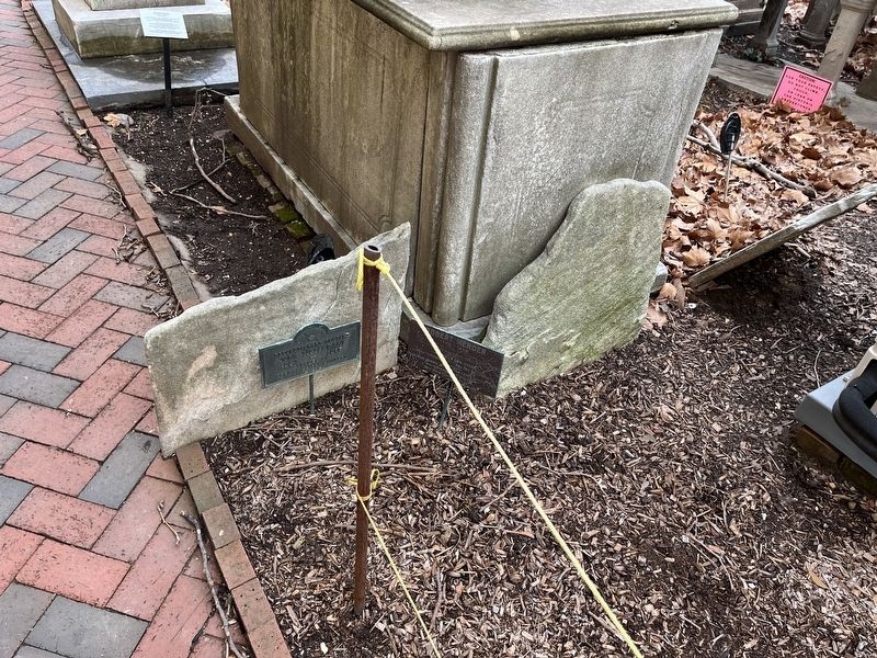
Near South 4th Street south of Locust Street, on the right when traveling south.
In 1793, after the dreaded Yellow Fever Epidemic of that year, The Trustees of Holy Trinity Church established a residence for orphans they found wandering on the streets. In 1807, the orphanage was legally incorporated as "The Roman Catholic . . . — — Map (db m213988) HM
Signer of the Constitution of the United States of America Deputy from Pennsylvania to Federal Constitutional Convention May 25, 1787 - September 17, 1787 — — Map (db m9138) HM
Near South 4th Street south of Locust Street, on the right when traveling south.
Thomas Fitzimons was born in County Tubber, Wicklow, Ireland in 1741. He immigrated to Philadelphia, where he married Catherine Meade on November 23, 1761. Eventually he established a West Indies Trading Company with George Meade, Catherine's . . . — — Map (db m213995) HM
On South 4th Street at Lawrence Court Walk, on the right when traveling south on South 4th Street.
Master Carpenter - Educator - Patriot
338 South Fourth Street
1767 - Lot purchased by Thomas Neval.
1771 - House completed. That same year Thomas Neval established the Carpenters' Guild, opening what is thought to be the first . . . — — Map (db m214002) HM
On Spruce Street, on the left when traveling west.
Has been designated a National Historic Landmark This site possesses national significance commemorating the history of the United States of America. 1980 — — Map (db m9101) HM
Quaker lawyer John Todd lived here with his wife Dolley, their two young children, and hunting dog "Pointer." Tragedy struck in 1793 when Dolley lost her husband during the yellow fever epidemic and their youngest child in the same year. Dolley . . . — — Map (db m79211) HM
In January of 1793 a delegation of tribal chieftains from what are now Illinois, Indiana, Ohio and Michigan arrived in Philadelphia, the U.S. capital. The Indians had been invited by President George Washington to a Peace Council to resolve boundary . . . — — Map (db m60993) HM
On South 6th Street just south of Walnut Street, on the left when traveling south.
One of the nation’s first urban penal institutions, it confined felons, prisoners of war, Tories, and debtors from 1775 to 1838. Extending from Walnut Street to Locust Street, it was the site of numerous riots. The prison was replaced by Eastern . . . — — Map (db m30718) HM
On Walnut Street at 6th Street, on the left when traveling west on Walnut Street.
Founder William Penn had a plan for Philadelphia. He wanted a prosperous, bustling city with straight, orderly streets. He also set aside five squares, establishing parks for the public. Both ideas influenced the design of many later American . . . — — Map (db m9024) HM
On Pine Street east of South 5th Street, on the right when traveling east.
Lieutenant, Philadelphia City Militia Artillery Battalion. Captain, First Artillery Battalion.
During War of 1812, became Quartermaster General United States Army Schuylkill Arsenal Philadelphia. 1813 promoted colonel.
For 33 years, . . . — — Map (db m214059) HM
In the 17th century, when the Square first appeared in the city plan, streams drained into a deep gully in front of you. Then, beginning in 1833, geometric paths invited visitors into a leveled square planted with hundreds of trees.
By 1846, . . . — — Map (db m9031) HM
Here in 1836 a church related company began printing hymnals, religious materials, and works by Black authors of the period. In 1847 The Christian Recorder was published here. Bishop Benjamin Tucker Tanner was editor of the firm until 1884. — — Map (db m83447) HM
On January 27, 1777, Deborah Norris wrote to her friend Sally Wister of a "shocking sight." Large pits are dug in the negroes burying ground (Washington Square), and forty or fifty (soldiers) coffins are put in the same hole.
Throughout that . . . — — Map (db m9047) HM
In unmarked graves within this square lie thousands of unknown soldiers of Washington’s Army who died of wounds and sickness during the Revolutionary War.
“The independence and liberty you possess are the work of joint councils and joint . . . — — Map (db m9051) HM
Near South 8th Street just north of Delancey Street, on the right when traveling south.
Pennsylvania Hospital was founded in 1751 by Dr. Thomas Bond and Benjamin Franklin. The question of a proper site for Colonial America's first hospital was a matter of great concern to the Managers who finally settled upon the square bounded by . . . — — Map (db m212629) HM
On 6th Street at Spruce Street, on the right when traveling south on 6th Street.
Holy Trinity was built in 1789 by Philadelphia's German Catholic community. It was the first parish church in the United States established specifically to serve a national group.
The religious turmoil and economic hardships of war-torn . . . — — Map (db m9097) HM
On South 6th Street at Spruce Street, on the right when traveling south on South 6th Street.
Founded by German-speaking immigrants in 1787 to preserve their language and customs, Holy Trinity Church was the first German Catholic parish in the U.S. and became a model for other ethnic Catholic parishes. The church was built in 1788-1789. By . . . — — Map (db m240170) HM
who, during the War for Independence, died prisoners of war in the jails of Philadelphia, and were buried in this ground during the years 1777 and 1778. — — Map (db m9027) HM
A statue of the most famous American, George Washington, stands near the Square's center. It keeps a vigil at the tomb of an unknown soldier who died during the War for Independence. Revolution linked them in life. This shrine joins them in our . . . — — Map (db m9045) HM
The financier, statesman, & scholar lived here. President, 1823-1836, Second Bank of the United States, the nation's central bank. He also spurred the rise of Greek Revival architecture and edited the journals of the Lewis & Clark expedition. — — Map (db m81989) HM
Near South 8th Street south of Delancey Street, on the right when traveling south.
The foundation of the East Wing was laid on May 28, 1755. The cornerstone, engraved with Benjamin Franklin's words, is still visible just beyond the original entrance. The first patients were moved in on December 17, 1756.
On the first floor . . . — — Map (db m214115) HM
Near South 8th Street just north of Delancey Street, on the right when traveling south.
This was the gatekeeper's lodge and the arched gateway was the carriage entrance. When the main entrance on Pine Street was closed at night, admission to the Hospital was obtained by arousing the gatekeeper by means of a large iron knocker which . . . — — Map (db m212628) HM
Near South 8th Street just south of Spruce Street, on the right when traveling south.
The Walter Garrett Memorial Building opened here in 1897. It housed clinical facilities, operating rooms, an early x-ray service and a ground floor emergency department, replacing the "recent accidents" unit in the old Elaboratory. The growing . . . — — Map (db m212632) HM
William Penn learned many lessons in life. Living in 17th century England taught him that open space offered breathing places for great cities and also slowed the spread of fire.
He applied what he had learned to Philadelphia. He insisted on . . . — — Map (db m9028) HM
Near South 8th Street south of Delancey Street, on the right when traveling south.
In the Year of Christ
MDCCLV.
George the Second happily reigning
(for he sought the happiness of his people)
Philadelphia flourishing
(for its inhabitants were publick spirited)
This building
by the bounty of the government, . . . — — Map (db m214116) HM
Has been designated a Registered National Historic Landmark under the provisions of the Historic Sites Act of August 21, 1935. This site possesses exceptional value in commemorating or illustrating the history of the United States. — — Map (db m79209) HM
Until the 19th century this was often a sorrowful place. Many people knew it as a potters field, a "publick burying place for all strangers," for soldiers, sailors, convicts, and the "destitute whose remains are walked over." A lonely Acadian . . . — — Map (db m9044) HM
Built by N.W. Ayer & Son, the nation's first advertising agency founded in Philadelphia in 1860, this was the agency's national headquarters from 1920 to 1973. Its architecture includes many elements symbolizing communication and reflecting the Art . . . — — Map (db m81980) HM
Philadelphia thrived. Founded in 1682, it became a haven of religious tolerance. As a Quaker and a victim of discrimination, William Penn believed strongly in allowing others to worship freely.
The city's growth rested on economics as well. . . . — — Map (db m9029) HM
The Greek Revival building at 700-714 Spruce Street were built between 1835 and 1838 on land originally owned by the Contributors to Pennsylvania Hospital. This drawing represents the facades of the buildings just prior to their preservation and . . . — — Map (db m81995) HM
On West Washington Square at South 6th Street on West Washington Square.
Dedicated to the officers and crew of the
U.S.S. Forrestal (CVT-59)
under the command of
Capt. R.L. "Bunky" Johnson, U.S.N.
From her arrival in May 1992 until her decommissioning in September, 1993 the crew of the Forrestal took . . . — — Map (db m210869) HM WM
On West Washington Square at South 6th Street on West Washington Square.
In grateful appreciation to the officers and crew of the
U.S.S. John F. Kennedy (CU-67)
under the command of
Capt. J.R. Hutchison, U.S.N.
Capt. Gerald Hoewing, U.S.N.
Every morning and evening from Nov. 1993 to Sept. 1995 an . . . — — Map (db m210867) HM
Washington Square (6.4 acres) is one of the original five squares laid out by William Penn and his surveyor Thomas Holme in the plan for the city of Philadelphia in 1682. First designated as Southeast Square, it was renamed Washington Square in 1825 . . . — — Map (db m9025) HM
On Market Street at South Independence Mall West (6th Street), on the right when traveling east on Market Street.
Nobody with dark skin could live without fear of the kidnappers who operated under a virtual man-hunter's license provided by the Fugitive Slave Act of 1793. For free Philadelphians of African descent, fear always stalked the streets as . . . — — Map (db m102438) HM
On Market Street at 7th Street, on the right when traveling east on Market Street.
Thomas Jefferson resided at his site while drafting the Declaration of Independence. In little more than two weeks, Jefferson finished his timeless defense of “life, liberty and the pursuit of happiness.”
While Jefferson labored over . . . — — Map (db m106131) HM
On Market Street at South Independence Mall West (6th Street), on the right when traveling east on Market Street.
In March of 1793, Washington signed the Fugitive Slave Act, which gave slave owners explicit authority to recover escaped slaved from any part of the nation. Some agents even took advantage of this law to kidnap free people of African descent. — — Map (db m102240) HM
On Market Street at South Independence Mall West (6th Street), on the right when traveling east on Market Street.
On July 4, 1795, angry Philadelphians crowded the streets to protest the ratification of the Jay Treaty. The mob burned an effigy of former Chief Justice John Jay, who had negotiated a treaty with England that many people despised for its . . . — — Map (db m102220) HM
On Market Street at South Independence Mall West (6th Street), on the right when traveling east on Market Street.
Hercules, Washington's enslaved chef, asked that his son Richmond be brought to Philadelphia. If Hercules wanted Richmond to witness free people of African descent in Philadelphia, his wish ended after a short period of time. Washington sent . . . — — Map (db m102439) HM
On Market Street at South Independence Mall West (6th Street), on the left when traveling west on Market Street.
Oney Judge's strong desire for freedom drove the 22-year-old enslaved seamstress to flee the President's House on May 21, 1796. With the help of friends of African descent, she found passage to New Hampshire, where she married, raised a family, . . . — — Map (db m179587) HM
Near Market Street (County Road 2004) just east of South 6th Street (County Road 2005), on the right when traveling east.
On November 22, 1790, President Washington arrived at the President's House to establish his home and office. With him were eight enslaved African descendents, ordered by Washington himself to be rotated back to Mount Vernon to evade Pennsylvania's . . . — — Map (db m179613) HM
On Market Street at South Independence Mall West (6th Street), on the left when traveling east on Market Street.
Many evenings, Oney Judge would sit on her pallet where she slept at the foot of Martha Washington's bed, sewing and listening to the First Lady read the Bible, sing hymns, and pray with her two granddaughters in the next room.
In the 1840s, . . . — — Map (db m102275) HM
On Market Street at South Independence Mall West (6th Street), on the right when traveling east on Market Street.
Abigail wrote to her sister in May of 1798 expressing her fears as the political debate heated up over President Adams' policies towards France. Over one thousand men marched in support of Adams on the street outside her window, while rumors . . . — — Map (db m102222) HM
On Market Street (County Road 2004) at South 6th Street (County Road 2005), on the right when traveling west on Market Street.
Developed as a memory wall, Indelible quotes from the Declaration of Independence as printed by John Dunlap by order of Congress in 1776. The artwork restores the condemnation of slave trade passage that was deleted by Congress . . . — — Map (db m146656) HM
On Market Street (County Road 2004) at South 6th Street (County Road 2005), on the right when traveling west on Market Street.
Developed as a memory wall, Indelible quotes from the Declaration of Independence as printed by John Dunlap by order of Congress in 1776. The artwork restores the condemnation of slave trade passage that was deleted by Congress . . . — — Map (db m227604) HM
On Market Street at North 6th Street, on the left when traveling north on Market Street.
My search in life has been for a new seeing, a new image, a new insight, a new consciousness. This search includes the object as well as the in-between places – the dawns and the dusks, the objective world, the heavenly spheres, the places . . . — — Map (db m106485)
On Market Street (County Road 2004) at North 4th Street, on the right when traveling west on Market Street.
The first commercial pretzel bakery was started in 1784 by an entrepreneur from Lancaster County. The tiny operation soon grew into a large factory and set the Philadelphia pretzel industry in motion. Created from the same ingredients that are . . . — — Map (db m213962) HM
On Market Street (County Road 2004) at South 6th Street, on the right when traveling east on Market Street.
This intersection of Market Street and Sixth Street has always been bustling with energy and traffic. This image from 1902 of southeastern corner looking east shows the variety of forms of transportation used at that time, including horse-drawn . . . — — Map (db m227589) HM
On Market Street at South Independence Mall West (6th Street), on the left when traveling west on Market Street.
In late August of 1793, leading members of the free African and white communities joined in a banquet to celebrate the roof raising of the first African church in Philadelphia. The dinner was in two parts, Dr. Benjamin Rush explained, "six of the . . . — — Map (db m102295) HM
The building at the corner of Library Street is a quaint and substantial example of the old style architecture where substance and solidity were objects of the first importance.
Public Ledger, April 20, 1887
On 7th Street at Market Street, on the left when traveling north on 7th Street.
Professional society created Oct. 6-8, 1852, to assure quality & safe distribution of drugs. Pharmacists from eight states met in a building nearby for the founding meeting; among them was Philadelphian William Procter, Jr., "Father of American . . . — — Map (db m8985) HM
On South 5th Street south of Chestnut Street, on the right when traveling south.
The American Philosophical Society ~ Founded by ~ Benjamin Franklin - 1743 - --------------------- Outgrowth of The Junto, 1727 : Reorganized 1769 The First Learned Society in the British Plantations in America -------------------- This . . . — — Map (db m106154) HM
Near Chestnut Street (County Road 3008) just west of South 5th Street (County Road 2003), on the right when traveling east.
The American Philosophical Society ~ Founded by ~ Benjamin Franklin - 1743 - --------------------- Outgrowth of The Junto, 1727 : Reorganized 1769 The First Learned Society in the British Plantations in America -------------------- This . . . — — Map (db m214100) HM
On Market Street at 6th Street, on the left when traveling west on Market Street.
Uncovering History How do we learn about the lives of those who came before us? Old documents such as letters, diaries, and land deeds tell us about particular people, places and events. Yet written records do not always survive and most were . . . — — Map (db m8981) HM
On Market Street at South Independence Mall West (6th Street), on the right when traveling east on Market Street.
In 1792, Otetiani, a Seneca orator and political leader, led a large delegation of Native American leaders to Philadelphia to negotiate a peace treaty between Native American nations in the Northwest Territory and the United States. In honor of . . . — — Map (db m102414) HM
On North 4th Street at Arch Street, on the right when traveling south on North 4th Street.
The class of 1930 at its 50th reunion honors Benjamin Franklin founder of the University of Pennsylvania which began at this site in 1749 and which in 1779 became the first university in this nation. We recognize the growth of our beloved . . . — — Map (db m9314) HM
On North 6th Street (Pennsylvania Route 30) south of Interstate 676, on the left when traveling south.
The Commissioners of the Delaware River Port Authority dedicate this bridge to the memory of a great patriot scientist and statesman and in his honor we name it the
Benjamin Franklin Bridge
The Delaware River Bridge Joint . . . — — Map (db m192991) HM
Near Arch Street just east of North 5th Street (County Road 2003), on the left when traveling west.
The Body of
B. Franklin, Printer,
Like the Cover of an old Book,
Its Contents torn out,
And Stript of its Lettering & Gilding,
Lies here, Food for Worms.
But the Work shall not be lost,
For it will as he believ'd
appear once more . . . — — Map (db m212552) HM
Near Arch Street, on the left when traveling west.
Father of American Psychiatry
Signer of the Declaration of Independence
Heroic Physician, Teacher, Humanitarian
Physician General of the Continental Army
Physician to the Pennsylvania Hospital
Professor of Physic, University of . . . — — Map (db m106480) HM
Near North Franklin Street just north of North 7th Street, on the right when traveling north.
From 1776 to 1788, Franklin square housed Philadelphia's black powder magazine, or storage place, for the city's ammunition that was used. It was of the utmost importance that the powder be away from the city's residents in the event of an . . . — — Map (db m192988) HM
Near Arch Street just east of North 5th Street (County Road 2003), on the left when traveling west.
Sacred
to the memory of
Captain Anthony Palmer
who departed this life
June 1, 1749
aged 85 years.
He served as acting Governor of Pennsylvania and was the founder of the Kensington area of Philadelphia. He is buried with his . . . — — Map (db m212562) HM
To the Sacred Memory of
Charles Mason
Surveyor - Astronomer - Scientist
April 1728 - October 25, 1786
English astronomer and surveyor who, with
Jeremiah Dixon, laid out the Mason-Dixon Line -
famous border between . . . — — Map (db m121275) HM
Near Market Street (County Road 2004) near South 6th Street, on the right when traveling east.
Skilled, strong, and determined, Washington's cook, Hercules prepared exceptional meals for the President's House, while also preparing for his eventual escape to freedom. — — Map (db m146649) HM
Christ Church Burial Ground is most famous as the final resting place of Benjamin Franklin, a man who captured the spirit of his age and of the city. Franklin's genius touched nearly every aspect of Philadelphia's life and produced many . . . — — Map (db m9315) HM
On Arch Street just east of North 5th Street (County Road 2003), on the left when traveling west.
This is the resting place of over 4000 people from many nations who were dedicated founders of the city of Philadelphia and American democracy. — — Map (db m212563) HM
On Arch Street at 5th Street, on the left when traveling west on Arch Street.
1706 Born at Boston, January 17. 1723 Removed to Philadelphia. 1729 Editor of Pennsylvania Gazette. 1730 Appointed Public Printer. 1731 Founded the Philadelphia Library. 1736 Organized the first Philadelphia Fire Company. 1737 Appointed Postmaster . . . — — Map (db m9318) HM
April 22, 1792 - March 22, 1862
Nissan 30, 5552 - Adar II 20, 5622
"I am an American, a sailor and a Jew."
Born in Philadelphia in 1792, Uriah Phillips Levy was a fifth generation American. According to family stories, he left for . . . — — Map (db m123962) HM
Near Market Street (County Road 2004) just east of South 6th Street (County Road 2005), on the right when traveling east.
In the 1790s, slave owners escaping the slave rebellion in Saint Domingue (now Haiti) came to Philadelphia, bringing enslaved Africans, yellow fever, and the suspicion that slavery might yield "dreadful insurrections." — — Map (db m146655) HM
528 entries matched your criteria. Entries 301 through 400 are listed above. ⊲ Previous 100 — Next 100 ⊳