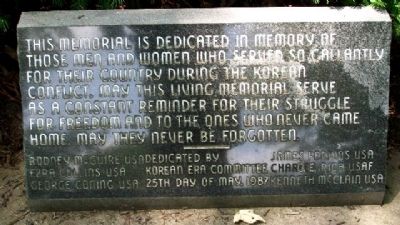
This memorial is dedicated in memory of
those men and women who served so gallantly
for their country during the Korean
Conflict, may this living memorial serve
as a constant reminder for their struggle
for freedom and to the ones who . . . — — Map (db m29990) WM
Honoring all Veterans
in times of peace and war
[Includes an Honor Roll of]
Area Veterans Who Died in the
Service of Their Country
Dedicated July 4, 2004 — — Map (db m29991) HM
Dedicated by the grateful citizens
of Middletown to the members
of the armed services who gave
their lives to preserve the
American ideals of liberty
justice and democracy
World War II Memorial
This plot contains a cross for . . . — — Map (db m29979) HM
On Central Avenue (Ohio Route 122) at N. Verity Parkway ( Route 73), on the right when traveling west on Central Avenue.
Canals were built in Ohio to provide a better way to transport goods to the eastern markets. Two major canals were built connecting the Ohio River to Lake Erie - the Ohio Erie & [sic Ohio & Erie] Canal running from Portsmouth to Cleveland and the . . . — — Map (db m30375) HM
On Central Avenue (Ohio Route 122) at N. Verity Parkway ( Route 73), on the right when traveling west on Central Avenue.
Port Middletown, located at Third St. (Central Ave.), was the main port along the Miami & Erie Canal. A scale was located there and tolls were collected.
[Photos] Left, a fire in 1881 at the Ben Smith Livery at Port Middletown has just been . . . — — Map (db m30418) HM
On Verity Parkway (Ohio Route 4/73) at Main Street / Tytus Avenue, on the left when traveling north on Verity Parkway.
About 20,000 years ago this pink granite boulder was brought from Canada by the Wisconsin Glacier and deposited near here, along the Great Miami River. — — Map (db m29625) HM
On Verity Parkway (Ohio Route 4/73) at Yankee Road, on the left when traveling south on Verity Parkway.
In emulation of those who, July 21, 1825,
here began the building of the
Miami & Erie Canal,
this Ohio property was rededicated
November 2, 1929, to its original purpose -
transportation, with the confident hope
that a super-highway . . . — — Map (db m29665) HM
On Central Avenue (Ohio Route 122) at N. Verity Parkway ( Route 73), on the right when traveling west on Central Avenue.
Ohio's canal system was the most effective between 1827 and 1850, before the introduction of the railroads. In Middletown, the canal was still used well into the 20th century but in 1913 a devastating flood destroyed much of the canal. In 1929 . . . — — Map (db m30430) HM
On Central Avenue (Ohio Route 122) at N. Verity Parkway ( Route 73), on the right when traveling west on Central Avenue.
The lift bridge built in 1899 across the Miami & Erie Canal at Third Street (now Central Ave.), was the third bridge at this site since the canal began in 1825. An electric motor was used to raise the west portion of the floor of the bridge up the . . . — — Map (db m30431) HM
On Verity Parkway (Ohio Route 4 / 73) at Main Street, on the right when traveling north on Verity Parkway.
Verity Pkw. once Miami-Erie Canal
an Underground Railroad route
1830 - 1860
Those traveling along Underground
Railroad found safe stations
in N. Main St. homes of
African-Americans
listed on other side
Rice • Hawkins • Colston . . . — — Map (db m29667) HM
On Clark Street at Manchester Avenue, on the right when traveling north on Clark Street.
Lest we forget their generation
Honoring the men and women who have served
But let us be glad that such heroes have lived
and mourn those who gave the ultimate sacrifice
“Battle of the Bulge”
800,000 soldiers . . . — — Map (db m29669) HM
Near Thomas Road at Middletown Germantown Road, on the right when traveling west.
Organized Sept. 2, 1819
Pastor Wilson Thompson
Clerk & Treasurer James Boles
Building Erected 1830
On land donated by Sam Lucas
170th Year
Dedicated Sept. 2, 1989 — — Map (db m246388) HM
On Reily Millville Road 0.1 miles east of Salman Road, on the left when traveling east.
William Holmes McGuffey, author of the Eclectic Series of Readers, was ordained a Presbyterian minister in a log meeting house on this site in 1829. The ordination was performed by Robert Bishop, President of Miami University, and other ministers . . . — — Map (db m24060) HM
On Reily Millville Road 0.3 miles east of Cochran Road, on the right when traveling east.
Was a native of Ireland.
Came to America about the close of the Revolutionary War.
Married Miss Martha Allen Gillespie in Washington Count I'a in the year 1783, removed to Cincinnati among the early settlers. Was a citizen of the village as . . . — — Map (db m275326) HM
On Elk Creek Road at Howe Road, on the right when traveling north on Elk Creek Road.
In c1795 Bambo Harris a freed black slave built and operated the first Water Driven gristmill in the area on Elk Creek. For fifty years his Millstones ground wheat and corn. A member of the Prairie Baptist Church, he was highly respected in the . . . — — Map (db m28779) HM
On Elk Creek Road at Howe Road, on the right when traveling north on Elk Creek Road.
The village of Miltonville, located along the banks of Elk Creek, was platted in 1816 by George Bennett, Theophilus Eaglesfield, and Richard V. V. Crane. The creek served two grist mills, one built around 1804 and operated by a free black, Bambo . . . — — Map (db m28776) HM
On East Elm Street at Cincinnati Dayton Road, on the right when traveling west on East Elm Street.
City of Monroe Monroe. Nathanial Sackett (1768-1854) and John H. Piatt (1781-1820) platted Monroe in 1817, naming it for President James Monroe. Monroe was a stagecoach stop between Cincinnati and Dayton and grew to be a rural village . . . — — Map (db m206448) HM
On Hamilton Lebanon Road (Ohio Route 63) at Cincinnati Dayton Rd, on the right when traveling east on Hamilton Lebanon Road.
This plaque is erected in honor of those people from the Monroe area who served their country in the armed forces during the Vietnam crisis
James L. Akison •
Jerry Bake •
John Blose •
Ralph M. Carpenter •
Chas. Chapman •
Lee . . . — — Map (db m206504) WM
On Okeana-Drewersburg Road 0.1 miles west of Cincinnati-Brookville Road ( Route 126), on the right when traveling west.
1858 Morgan Township House
On April 20, 1857, the trustees of Morgan Township met in Okeana to obtain a lot for the township house. From a quarter mill tax levy, $850 was budgeted for a house and lot. Money expended on the project included . . . — — Map (db m24000) HM
Edward Bebb, father of William Bebb and first Welshman to settle in Paddy's Run, Morgan Township, Butler County purchased this cabin in 1801. Originally the cabin stood four miles southeast of this site on the Dry Fork of the Whitewater River. It . . . — — Map (db m24001) HM
Our Founding Members
Earl Bennett
Zelotes Brown
Homer Davis
Leonard Fagaly
Robert L. Kimball
Fred Mabis
Eli Parkhurst
Stanley Scheering
Carl Skjoldager
Frank L. Tompkins
This Fire Station is
dedicated in memory of . . . — — Map (db m24782) HM
On East Walnut Street at South Campus Ave, on the left when traveling east on East Walnut Street.
In October 1833 was organized
at Old Miami a chapter of Alpha
Delta Phi- the first Greek letter
fraternity to expand west of
the Alleghenies. With this event
Miami became the fourth college
in the United States to . . . — — Map (db m107742) HM
On Western College Drive, on the left when traveling south.
Alumnae Hall
Built: 1890- 1892
Razed: 1977
Born of the vision of President Leila McKee and built through the generousity of
Olivia Meily Brice, Class of 1866 and Western’s first woman Trustee,
Alumnae Hall was truly the gift of women to . . . — — Map (db m107803) HM
On South Campus Avenue at East High Street, on the right when traveling south on South Campus Avenue.
First president general
National Society Daughters of
the American Revolution.
Wife of Benjamin Harrison
23rd president of
the United States of America — — Map (db m275223) HM
On Reily-Millville Road (County Route 29) 0.2 miles west of Bunker Hill Woods Road, on the right when traveling east.
Bunker Hill Universalist Church. The Bunker Hill Society was organized about 1845 and fellowshipped in 1854. A frame meeting house, capable of seating 300, was dedicated in 1855. Thirty people united with the church during the 1859 Annual . . . — — Map (db m107789) HM
On Western College Drive at South Patterson Avenue, on the right when traveling south on Western College Drive.
When the Western College for Women opened its campus (now a part of the Miami University campus) to civil rights activists in the summer of 1964, college students and volunteers from across the country trained here for the Mississippi Summer . . . — — Map (db m275313) HM
On Western College Drive, on the right when traveling south.
In what was called the "Freedom Summer" of 1964, more than 800 volunteers, most of them college students, gathered at the Western College for Women (now Western Campus of Miami University) to prepare for African-American voter registration in the . . . — — Map (db m107802) HM
On Indian Creek Road (County Route 37), on the left when traveling east.
The Indian Creek Regular Baptist Church was established in 1810 as an arm of the Little Cedar Creek Church of Brookville, Indiana. The congregation purchased three acres of land for a burial ground and church and built a log structure here in . . . — — Map (db m120291) HM
Near Indian Creek Road 0.7 miles north of Imhoff Road, on the right when traveling north.
Brick church built - 1829
Indian Creek Cemetery on first county land sold for public burial
Preserved by Indian Creek Cemetery Association, 1880 - 1959 — — Map (db m166727) HM
On Patterson Avenue (U.S. 27), on the left when traveling south.
Side A: Langstroth Cottage Reverend Lorenzo Langstroth, renowned as "The Father of American Beekeeping," lived in this simple two-story, eight-room house with his wife, Anne, and their three children from 1858 to 1887. Unchanged externally, the . . . — — Map (db m24009) HM
On West High Street (U.S. 27) at West Park Place, on the right when traveling west on West High Street.
Lynching in America. Between 1865 to 1950, thousands of African Americans were victims of mob violence and lynching across the United States. Following the Civil War, fierce resistance to equal rights for African Americans and an ideology of . . . — — Map (db m178139) HM
On Oxford Street at Hamilton-Richmond Road, on the left when traveling north on Oxford Street.
Milford Township Veterans Memorial
The seventh township in order of creation, it was erected from St. Clair Township by the Butler County Commissioners on December 2, 1805 — — Map (db m103319) HM WM
On South Campus Ave at East Walnut, on the right when traveling south on South Campus Ave.
In 1833, Samuel Eells founded Alpha Delta Phi (ΑΔΦ), the first fraternity west of the Allegheny Mountains and the first fraternity at Miami University. The formation of Miami's Alpha (founding) chapters followed in the next two . . . — — Map (db m107741) HM
On South College Ave, on the right when traveling south.
Oxford Female Institute Chartered in 1849, the Institute was the first of three women's colleges established in Oxford. The original brick building was completed in 1850, and forms the core structure. The Reverend John Witherspoon Scott, a . . . — — Map (db m107675) HM
On Brown Road at Doty Road, on the right when traveling north on Brown Road.
This structure with Italianate features served as the Oxford Township Clerks Office and the meeting location for the township trustees from about 1890 until 1960. Built at 115 West High Street, Oxford, after the Civil War, it was moved to the . . . — — Map (db m275169) HM
On Main Street (Ohio Route 732) at High Street (U.S. 27), on the left when traveling north on Main Street.
In honor of all veterans
who proudly served
our country and flag
Gratefully dedicated
to those who offered their lives
in the cause of freedom
Dr. Martin Luther King, Jr.
Memorial Park
“When people get caught up . . . — — Map (db m24783) HM
Near Bishop Circle 0.1 miles west of South Patterson Avenue (U.S. 27), on the right when traveling south.
Percy Mackaye
Percy MacKaye (1875-1956) was a poet and dramatist elected to the National Institute of Arts and Letters in 1914. From 1920-1924, MacKaye held the position of writer-in-residence at Miami University, the first position of its . . . — — Map (db m140417) HM
On East High Street at South Campus Avenue, on the right when traveling east on East High Street.
To the memory of the sons of Phi Delta Theta who gave their lives in the wars of our country.
Their sacrifice will be remembered by continuing generations who will strive to fulfill their dream of lasting peace and universal brotherhood. — — Map (db m275219) WM
On East Park Place at East High Street (U.S. 27), on the left when traveling south on East Park Place.
Thomas Cowan Bell, James Parks Caldwell, Daniel William Cooper, Isaac M. Jordan, William Lewis Lockwood, Benjamin Piatt Runkle, and Franklin Howard Scobey met in a second floor room of this building to found Sigma Chi (ΣΧ) in early . . . — — Map (db m227310) HM
On East Spring Street at Oak Street, on the left when traveling west on East Spring Street.
Stanton's "Magnificent Dwelling"
Home of Two Miami University Presidents
Built by “Old Miami” University President Robert L. Stanton, D.D. (1810-1885) as his private home and president’s office, Stanton’s 1868 Italianate house faced . . . — — Map (db m225372) HM
Near Oxford Millville Road (U.S. 27) 0.3 miles north of Stillwell Beckett Road, on the right when traveling north.
In remembrance of
our fallen heroes
known only but to God
James Ryan, Pvt Co B 35, Ohio Infantry, Civil War, 1830 - 1863 •
Levi Blackford, Pvt Co E 69, OVI, Civil War, 1844 - 1862 •
John Ayers, Pvt Capt Gibson's Co, Ohio Artillery, War of . . . — — Map (db m275321) WM
Near Oxford Millville Road (U.S. 27) 0.3 miles north of Stillwell Beckett Road, on the right when traveling north.
side A
A cemetery was established on the site in 1811 and became the final resting place for many of the area's early pioneer families. The Hanover Township Trustees obtained title to the land in 1823 from John and Anna Farnsworth, and it . . . — — Map (db m97814) HM
(bust of Washington)
The Act of 1794
In the name of the United States of America: It is hereby declared that
one complete township or tract of land, of six miles square, to be located
with the approbation of the governor, for the . . . — — Map (db m116659) HM
Front One of the few remaining covered bridges in southwestern Ohio and the only one in Butler County on its original site, this bridge was built in 1868-1869 to give access to a saw and grist mill owned by James B. Pugh on Four Mile . . . — — Map (db m86977) HM
The DeWitt Family. Zachariah Price DeWitt was born of a Dutch family in New Jersey in 1768. With brothers Jacob and Peter, he migrated to Kentucky where, in 1790, he married Elizabeth Teets, who was born in Pennsylvania in 1774. By 1805 all . . . — — Map (db m24064) HM
On Brown Road at Doty Road, on the right when traveling north on Brown Road.
Side A: The Doty Settlement
As Oxford Township was developing in the mid-1800s, a cluster of farmsteads near its northern border was designated the "Doty Settlement." As was the custom, the community took its name from a prominent family in . . . — — Map (db m24015) HM
Near Trenton Oxford Road (Ohio Route 73) west of Retreat Lane, on the right when traveling west. Reported missing.
This original dug well relates to one of the several fascinating legends of Zachariah and Elizabeth DeWitt. As reported by Ralph McGinnis in The History of Oxford, Ohio, from the Earliest Days to the Present, Zachariah heard Elizabeth's . . . — — Map (db m251239) HM
On Brown Road 0.2 miles south of Doty Road, on the right when traveling south.
The Restoration Movement
In the early years of the nineteenth century, a religious unrest known as the Second Great Awakening spread across much of the American frontier. Among the most influential of the evolving religious organizations . . . — — Map (db m24051) HM
On East Park Place at East High Street, on the right when traveling north on East Park Place.
Was founded here
June 28, 1855
by
Thomas Cowan Bell • James Parks Caldwell • Daniel William Cooper • Isaac M. Jordan • William Lewis Lockwood • Benjamin Piatt Runkle • Franklin Howard Scobey — — Map (db m275217) HM
On Patterson Avenue (U.S. 27) at Oxford-Trenton Road ( Route 73), on the left when traveling south on Patterson Avenue.
The life of Verlin L. Pulley was
long intertwined with Miami University.
A member of the class of 1925
A trustee from 1959 to 1965
A resident orf Oxford since graduation
and mayor of Oxford from 1936-1940
The founder of Capitol Varsity . . . — — Map (db m25006) HM
Near Bishop Circle 0.2 miles west of South Patterson Avenue (U.S. 27), on the right when traveling south.
This building is named for
the fourteenth president
of the university
1928-1945
who met the challenges
of depression and war
Alfred H. Upham
Member of the class of 1897
whose "Old Miami" tells the
story of her first . . . — — Map (db m140481) HM
On Western College Drive at South Patterson Avenue, on the right when traveling south on Western College Drive.
Between 1853 and 1974 the Western College, founded as the Western Female Seminary, pioneered in women's education, focusing on the liberal arts with a multicultural emphasis.
After the close of the college in 1974, a group of alumnae and friends . . . — — Map (db m275315) HM
On Campus Avenue at Spring Street, on the right when traveling north on Campus Avenue.
Who, while professor in Miami
University compiled the famous
McGuffey Readers which established
the social standards of the Great
Middle West of the United States
for three-quarters of a century.
Professor of Miami University 1825-36 . . . — — Map (db m24781) HM
On Spring Street at Oak Street, on the right when traveling east on Spring Street.
William Holmes McGuffey (1800-1873) was a Miami University faculty member in 1836 when he compiled the first edition of the McGuffey Eclectic Reader in this house. His Reader taught lessons in reading, spelling, and civic education by . . . — — Map (db m24012) HM
On East Spring Street at South Campus Avenue, on the right when traveling east on East Spring Street.
This idyllic campus of learning and growth is made possible by all who have accepted the responsibility of safekeeping our freedom. Honored here are the Miami University alumni who have served in the five branches of the military. The memorial is . . . — — Map (db m279099) WM
On Irvin Drive at East High Street on Irvin Drive.
This tower
was presented
to
Miami University
by
Beta Theta Pi
the first
college fraternity to
be founded west of the
Allegheny Mountains.
Celebrating one hundred
fifty years of cherished
brotherhood on
August 8 . . . — — Map (db m275228) HM
On South Patterson Avenue at Western College Drive, on the right when traveling north on South Patterson Avenue.
Home (1858-1885) of Lorenzo Lorraine Langstroth (1810-1895). Minister and pioneer apiculturist, he developed a revolutionary hive (pat. 1852) and honeybee management techniques, with his discovery of Beespace modern beekeeping began.
This . . . — — Map (db m275286) HM
On Irving Drive at East High Street, on the right when traveling north on Irving Drive.
In 2010, nearly all of Miami's Oxford campus buildings were heated and cooled by carbon-intensive steam.
Now, Miami is well on its way to moving nearly ALL buildings off steam, thanks to the conversion of our energy systems to geothermal . . . — — Map (db m275230) HM
On Bishop Circle at Laws Drive, on the right when traveling south on Bishop Circle.
Descended from a single individual brought from China in 1907, this species now graces gardens throughout the U.S. but is declining in its native range. — — Map (db m275237) HM
On Bishop Circle at Laws Drive, on the right when traveling south on Bishop Circle.
Near this place stood the studio of Percy Mackaye poet-in-residence 1920-1924
Trees of Miami, beautiful trees...
Truth, rememberance, youth -
of these you brood
In your ancient reveries.
-Percy Mackaye . . . — — Map (db m275234) HM
On South Patterson Avenue at Bishop Circle, on the right when traveling south on South Patterson Avenue.
Given in loving remembrance of
Robert Hamilton Bishop, M.D.
1879 - 1955
by his wife
Rev. Robert Hamilton Bishop, D.D.
first president, 1824-1841
Robert Hamilton Bishop D.D.
class of 1831
instructor, professor
secretary board of . . . — — Map (db m275238) HM
On East Spring Street at South Oak Street, on the right when traveling east on East Spring Street.
This Armory Sundial was a gift to the University in 1962 on the occasion of the 50th anniversary of its founding by the Miami Chapter of Delta Delta Delta
Set on true north, this precision instrument was made for the spot on which it . . . — — Map (db m275284) HM
On South Oak Street at East Spring Street, on the right when traveling north on South Oak Street.
The Beeps Edible Demonstration Garden was established in 2017 through the combined efforts of students enrolled in IES 474, the BEEPS Foundation, the McGuffey House and Museum, and Physical Facilities at Miami University. This garden is meant to . . . — — Map (db m275285) HM
On East Chestnut Street, on the left when traveling west.
Woodside Cemetery
Established as the Oxford Township Cemetery in 1880, this public graveyard replaced the original one at the corner of College Avenue and Spring Street. That earlier burial ground was abandoned when the railroad bisected it . . . — — Map (db m227942) HM
Near Western College Drive east of Wil Haygood Lane.
Ernst Nature Theatre was designed by the internationally acclaimed landscape design firm the Olmsted Brothers of Brookline, Massachusetts. It was built into the landscape as an outdoor performance space in 1921. The brothers were co-founders of the . . . — — Map (db m279718) HM
On Western College Drive at Western College Drive, on the right when traveling south on Western College Drive.
James Chaney, 21, Andrew Goodman, 20, And Michael Schwerner, 24, trained at Western College for Women before heading south to register black voters as part of the Mississippi Freedom Summer Project.
They left Oxford June 20, 1964, and . . . — — Map (db m289346) HM
Near Indian Creek Road 0.5 miles west of Imhoff Road, on the right when traveling north.
1809
Local Regular Baptists begin meeting in Reily Township. Meetings are held in nearby houses, as a church has not yet been built.
1810
The Indian Creek Regular Baptist Church is formally organized in the cabin of John Morris. The . . . — — Map (db m275322) HM
On West Ritter Street at Mill Street ( Route 503), on the left when traveling west on West Ritter Street.
The Seven Mile Academy was built in 1857 and was in continuous service until razed in 1993. This bell was in service at that Academy for many years. It was discovered in storage at the old Academy and was removed to the Board of Education until . . . — — Map (db m157051) HM
On Cincinnati-Brookville Road (Ohio Route 126), on the right when traveling east.
The foundation for the first Welsh settlement in Ohio was laid on June 29, 1801, when William and Morgan Gwilym purchased land in what is now Morgan Township at the Cincinnati Land Office. The Welsh, who settled in Pennsylvania beginning in the late . . . — — Map (db m23991) HM
On Bull Dog Drive at Church Street, on the right when traveling south on Bull Dog Drive.
Dedicated to the
memory of all
those who served.
In Honor of Somerville School
Community funded by Somerville
"Pay It Forward"
1916 - 2016
Centennial Celebration — — Map (db m275166) WM
On State Street (Ohio Route 73) at Miami Street / Hamilton Road, on the left when traveling west on State Street.
Site of the home of Trenton's founder, Michael Pearce, and his wife, Phebe Squier Pearce. The family migrated from New Jersey in 1801, purchased 1,500 acres, and settled in this location. Michael Pearce and David Enyeart platted the village of 33 . . . — — Map (db m29681) HM
On West State Street (Ohio Route 73) at Hamilton Trenton Road, on the right when traveling east on West State Street.
The earliest church established in Butler County and the first church built in Trenton.
All that remains are the original, steps to the two front doors of the church. — — Map (db m275813) HM
On State Street (Ohio Route 73) at Miami Street / Hamilton Road, on the left when traveling west on State Street.
Side A: The Village of Trenton
Platted 1816. Incorporated as Village 1895. Became a city 1971
Trenton's founder, Michael Pearce, came to the area in 1801. The original village of 33 lots was named Bloomfield. When the post office was . . . — — Map (db m28792) HM
On Woodsdale Road 0.4 miles east of Wayne Madison Road, on the right when traveling west.
The summer kitchen played a significant role in the history of the Chrisholm Farmstead. In addition to being used as a kitchen it also served as a butchering center, bakery, storage space, carriage house, and eventually a garage. The Augspurgers . . . — — Map (db m275808) HM
On Tylersville Road 0.9 miles east of I-75 Exit 22, on the left when traveling east.
During the height of World War II, President Franklin Roosevelt turned to the innovative engineers of the Crosley Broadcasting Corporation to build powerful short wave radio transmitters capable of delivering broadcasts overseas. On farm fields . . . — — Map (db m23994) HM
Near Woodsdale Road 0.4 miles east of Wayne Madison Road, on the right when traveling west.
The Story of the Alsdorf Windmill
The windmill installed here is a Model 602 produced by the Aeromotor Company of Chicago, Illinois. The 602 was produced between 1888 and 1933, and the windmill that stands here at Chrisholm was manufactured . . . — — Map (db m275805) HM
Near Woodsdale Road 0.5 miles east of Wayne Madison Road, on the right when traveling west.
This cemetery is the second oldest surviving Amish cemetery in Butler County, Ohio. Set aside by early Amish Pioneer Christian Augspurger, this plot of land was originally fenced by Augspurger's son, Samuel, in 1848, the year of his father's death. . . . — — Map (db m275811) HM
On Woodsdale Road (County Route 150), on the right when traveling west.
Chrisholm
This farm, Chrisholm (German for home farm of Christian Augspurger), was established in 1830 by Christian Augspurger (1782-1848), leader of the Amish Mennonite settlement in Butler County. The Amish selected this area because of . . . — — Map (db m275155) HM
Near Woodsdale Road 0.4 miles east of Wayne Madison Road, on the right when traveling west.
Historically, this area was covered by forests.
Over time people were drawn to the Ohio Valley for its rich soil and abundance of natural resources. Settlers cleared the land to raise crops and farm animals. Further development brought homes, . . . — — Map (db m275806) HM
Near Woodsdale Road at Wayne Madison Road, on the right when traveling west.
One of John Augspurger's many inventions was his version of the portable fence, which was patented on April 16, 1867. So unique was the invention that it won the grand prize at the 18th Ohio State Fair in 1867.
In addition to gaining instant . . . — — Map (db m275810) HM
Near Woodsdale Road 0.5 miles east of Wayne Madison Road, on the right when traveling west.
This "sanitary" outhouse is typical of those built by the Works Progress Administration in the early 1930's and eventually nicknamed The Eleanor.
In the early 1930's our nation fell into a great depression. Many people were out of work, the stock . . . — — Map (db m275803) HM
On Woodsdale Road 0.4 miles east of Wayne Madison Road, on the right when traveling west.
In 1819, Christian Augspurger led a group of six German-speaking families from the Alsace region of France to establish an Amish settlement in Butler County, Ohio. This became one of the first Amish communities in Ohio and the westernmost in . . . — — Map (db m275809) HM
Near Woodsdale Road 0.4 miles east of Wayne Madison Road, on the right when traveling west.
Welcome
This public facility was built by the Friends of Chrisholm and MetroParks of Butler County to provide needed amenities for visitors to this historic site, AND to demonstrate an innovative way to conserve our water. We have abundant, . . . — — Map (db m275804) HM
Near Woodsdale Road 0.4 miles Wayne Madison Road, on the right when traveling west.
The Chrisholm cellar is unlike any house cellar existing in Butler County today. Constructed to accommodate multiple uses it was primarily a place to store and preserve food grown on the farm. There are two separate entrances, one through a . . . — — Map (db m275807) HM
On Indian Drive at Mound Circle, in the median on Indian Drive.
This Adena Mound is the second largest
conical mound in Ohio. These large conical
mounds are believed to be Adena while the
many small or effigy mounds are Hopewell,
a later culture.
This mound is the property of the Village
of Enon. . . . — — Map (db m100536) HM
On Mound Circle at Indian Drive, in the median on Mound Circle.
First settlers in the area were the Adena Native Americans, known for their mounds like the one in Enon, Ohio. Adena, Hopewell, and Fort Ancient cultures developed earthworks, circa 52 BC to 1500 AD. These three nations were located in much of the . . . — — Map (db m175284) HM
Near Dayton- Springfield Road (County Route 333) at Winding Dr..
This memorial is dedicated
by the Enon Community
Historical Society May 2016
to preserve the history of
one of the first Civil War
Memorials placed east of
the Mississippi. The citizens
of Mad River Township
donated and dedicated . . . — — Map (db m110399) WM
On Spangler Road at East Main Street, on the right when traveling north on Spangler Road.
Benjamin Garver Lamme
Born January 12, 1864 on a farm on Lower Valley Pike, Bethel Township. Died July 8, 1924 Pittsburgh, PA.
Lamme joined the Westinghouse Electric Company in 1880, where he helped develop the Niagara Falls power system. . . . — — Map (db m175277) HM
On Spangler Road at East Main Street, on the right when traveling north on Spangler Road.
The Powerhouse at Medway
In 1899 the Dayton, Springfield & Urbana Railway began construction of a new powerhouse. The existing millrace supplied the water for a steam generation system for direct current electricity, and the plant was . . . — — Map (db m175278) HM