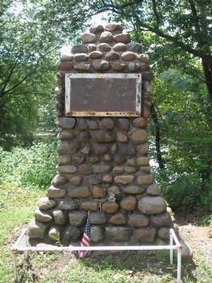
On Rock Road at Doremus Avenue, on the left when traveling west on Rock Road.
World War 1914 - 1918
Glen Rock Honor Roll
They Fought The Good Fight. They Finished
The Course. They Kept The Faith
* Peter W. Ebbert • * Frederick Jensen • * Mortimer Kerr • * Jacob E. Phillips • * Frank Squires • John Ackerman • Roland . . . — — Map (db m32419) HM
On Rock Road at Harding Road, on the left when traveling west on Rock Road.
For God And Country
Glen Rock
Honored Heroes
World War II Korean War
Vietnam War
1941 World War II 1945
William P. Abbott • Hubert Banks • James G. Barklie • Richard J. Boonstra • William R. Francis • Charles J. Haeberle • Robert . . . — — Map (db m32416) WM
On Spotswood Road 0.1 miles west of Delmar Avenue, on the left when traveling west.
Located on the boundary between two Hopper farms, the cemetery was shared by both families and their relatives for almost one hundred years. The earliest known burial was in 1804. — — Map (db m36966) HM
On Hillman Avenue at Ackerman Avenue, on the right when traveling south on Hillman Avenue.
North wing built 1780 by Hendrick H. Hopper in area then called “Small Lots”. Center section erected by son John, in early 1800’s. The farmhouse was sold to the Hillmann family in 1895, ending four generations and 115 years of continuous Hopper . . . — — Map (db m36967) HM
On Prospect Street at Locust Road, on the left when traveling north on Prospect Street.
Located in “Small Lots”, Henry G. Hopper began the construction of this house about 1788 on a 120 acre farm. Son Garret erected the Dutch-style main house in the early 1800’s. The north frame wing was built in the 1850’s for his son Thomas who . . . — — Map (db m36971) HM
On Rock Road at Ackerman Avenue, on the right when traveling west on Rock Road.
This former one room Schoolhouse was the original Ridgewood Grove School Number 44. Built in 1846 it was used until 1894 by Ridgewood Township. In 1894 the proposed closing of this school resulted in the incorporation of the Borough of Glen Rock. It . . . — — Map (db m36969) HM
On Main Street north of Bradford Street, on the right when traveling north.
This Bell
Symbolic of Freedom
is the gift of
The Navy Department
to the Borough of Glen Rock
December 1954
From the Destroyer USS Lang (DD 399)
a veteran of ten operations
World War II; named in memory of
Seaman James Lang, . . . — — Map (db m209463) HM WM
On Moore Street at Court Street, on the left when traveling south on Moore Street.
Archibald Campbell – 1730 – 12/28/1798, age 68. Born on the Isle of Man, came to Hackensack in 1765. Tavern keeper, host to General George Washington. Hackensack’s first Postmaster. Exemplary in all the duties of life, a . . . — — Map (db m62947) HM
On Main Street at Morris Street, on the left when traveling north on Main Street.
Archibald Campbell’s tavern stood here. He supplied meals to General Washington when Peter Zabriskie’s home was used as military headquarters between November 13 and November 21, 1776 during the retreat across New Jersey. The army marched down Main . . . — — Map (db m7227) HM
On Main Street at Court Street, on the right when traveling north on Main Street.
In remembrance of the Armenian Genocide 1915 – 1923 where 1,500,000 innocent Armenians were massacred by the Ottoman Turks. Dedicated July 8, 1990 — — Map (db m62945) HM
On Washington Place at Court St., on the left when traveling east on Washington Place.
Erected about 1831 by the Washington Banking Company. The first bank in present Bergen County, it opened in the nearby Mansion House in 1825-26. After the bank failed in 1833, it housed the offices of prominent lawyers and judges. Later the home of . . . — — Map (db m6817) HM
On Court Street at Moore Street, on the right when traveling east on Court Street.
Bergen County Court House. James Riely Gordon (1863–1937), noted architect of public buildings used the Beaux Arts style to reflect the power and dignity of American institutions of government and justice. Ground was broken November 29, 1909 . . . — — Map (db m6869) HM
On Court Street at Moore Street, on the right when traveling east on Court Street.
The Bergen County Jail is an impressive and oppressive building. It has a cruciform plan with a castellated exterior, marked by a heavily corbelled battlement and a squat central octagonal tower. Its fortress style of architecture, a prototype of . . . — — Map (db m62941) HM
Near River Street at Bridge Street, on the right when traveling north.
Specifications: Caliber: 40 MM Weight: 6,500 lbs Rate of Fire: 160 Rounds per Min. Range: 4500 Yards (Tracer Burn Out) Velocity: 2890 ft/sec Warhead: Armor Piercing/High Explosive This weapon could be used as a single gun or in multiple mounts. . . . — — Map (db m108415) HM
On Court St. at Church St., on the left when traveling east on Court St..
Dedicated to the memory of
Brigadier General Enoch Poor
by the New Jersey Society
of the Sons of the American Revolution:
Born at Andover, Mass., June 21, 1736;
Died near Hackensack, N.J., Sept. 8, 1780.
In command of a New . . . — — Map (db m6812) HM
On Main Street at Court Street, on the right when traveling north on Main Street.
In memory of hundreds of thousands of women and girls from Korea, China, Taiwan, the Philippines, the Netherlands, and Indonesia who were forced into sexual slavery by the Armed Forces of Imperial Japan before and during World War II. Dedicated on . . . — — Map (db m64465) HM
On Washington Place at Main Street, on the left when traveling east on Washington Place.
The first house built in the City of Hackensack was that of Dr. Van Emburgh (1686) located along a creek at the rear of the Court House. Early settlers had huts on this creek where they traded furs with the Indians. — — Map (db m62938) HM
On Court Street at Moore Street, on the left when traveling east on Court Street.
This tablet marks the site of the original church erected in 1696. Placed by Paskack Chapter Daughters of the American Revolution 1930 — — Map (db m62948) HM
On Court Street at Moore Street, on the right when traveling west on Court Street.
In memory of the Honorable Brigadier Gen. Enoch Poor of the State of New Hampshire who departed this life on the 8 day of Sept. 1780 aged 44 Years.---------------Washington, Lafayette and a portion of the American army attended the burial of Gen. . . . — — Map (db m62951) HM
On Main Street at Washington Place, on the right when traveling north on Main Street.
Hackensack became the County Seat of Bergen in 1709. The name “Bergen” was probably from “Bergen Op Zoom,” a major town in Holland. — — Map (db m62937) HM
Erected in 1924 by the people of Hackensack in Memory of its soldiers and sailors who fought in the wars of the United States of America.
[Four panels around the monument's base depict different American wars] — — Map (db m6873) HM
On Court St. at Church St., on the left when traveling east on Court St..
Earliest records of this pioneer Dutch church, dated 1686, mark it as the second oldest in New Jersey. Old stones embedded in the east wall show the initials of founding families and first settlers.
The old burying ground contains the grave of . . . — — Map (db m6820) HM
On Main Street at Court Street, on the right when traveling north on Main Street.
In memory of the millions killed in the holocaust 1939 – 1945 Bergen County Board of Freeholders Doris Mahalick, Director D. Bennett Mazur Gerald A. Calabrese • Joseph Carucci, Jr. • John F. Curran • Harry J. Gerecke • Jeremiah F. O’Connor • . . . — — Map (db m62946) HM
Built in 1818, by John I. Hopper in old “Polifly”, this Federal style house stands on land purchased in 1694 by his great-grandfather Hendrick. The farm remained in the Hopper family for seven generations. Slaves lived in the kitchen . . . — — Map (db m6864) HM
Near River Street at Bridge Street, on the right when traveling north. Reported missing.
The Lark Anti-aircraft Missile Program began in late 1944, when the U.S. Navy needed a new weapon against the ever more serious Japanese suicide-bomber (Kamikaze) threat. In January 1945, a Lark configuration had been established and requirements . . . — — Map (db m108420) HM
On Main Street at Washington Place, on the right when traveling north on Main Street.
Peter Zabriskie built a home here in 1751 which contained fine appointments including Dutch tile fireplaces depicting biblical scenes. Enlarged in 1776, the home was called Mansion House later Mansion Hotel. The structure was demolished in 1945. — — Map (db m62936) HM
On Central Avenue west of 2nd Street, on the right when traveling west.
This tablet is dedicated to the founders, deacons and men who served in the World War of Mt. Olive Baptist Church, Hackensack, N.J.
This church organized 1889 by the following members
Lucy B. Pickett •
Washington White •
James . . . — — Map (db m291237) HM WM
On 1st Street at Berdan Place, on the right when traveling north on 1st Street.
Third oldest African American Church in Hackensack, built by North Carolina carpenters who migrated here. Services began in 1920 with Reverend J.P.E. Love as founding Pastor. Building of the sanctuary began in 1921 and services began in the new . . . — — Map (db m291234) HM
On Hudson Street, on the right when traveling north.
Soldiers of the Revolution are buried in this cemetery of the True Reformed Dutch Church Deeded by Robert Campbell March 8, 1833 Erected by the Bergen County Historical Society 1937 — — Map (db m7229) HM
On Main Street at Court Street, on the right when traveling north on Main Street.
In memory of the millions of African people who perished during the middle passage, suffered the horrors of slavery, and endured the inhumanity of racial segregation. We also remember the heroes who have struggled and continue to work for freedom, . . . — — Map (db m62943) HM
Near River Street at Bridge Street, on the right when traveling north.
U.S. Navy submarines paid heavily for their success in World War II. A total of 374 officers and 3131 men are on board these 52 U.S. Submarines still on “patrol.” Albacore • Amberjack • Argonaut • Barbel • Bonefish • Bullhead • Capelin . . . — — Map (db m108413) HM
On Main Street at Court Street, on the right when traveling north on Main Street.
In memory of the millions of Irish people lost to imposed starvation, death and forced emigration by the English government. Bergen County Council of Irish Associations November 25, 1995 — — Map (db m62944) HM
Hackensack was a small village centered around The Green which served as a strategic point during the American Revolution.
Washington headquartered here in November 1776 while he surveyed the local roads and bridges. — — Map (db m6867) HM
On Moore Street near Court Street, on the left when traveling south.
In honor of The Huguenots on the Hackensack 1677 --------------- Erected by The Society of Colonial Wars in the State of New Jersey 1942 — — Map (db m62942) HM
Near River Street at Bridge Street, on the right when traveling north.
Launched August 15, 1943
Commissioned – June 8, 1945 – Boston
Sponsor Mrs. Edward J. Foy
First Captain – Commander G. G. Molumphy — — Map (db m108414) HM
Near River Street at Bridge Street, on the right when traveling north. Reported missing.
This type of mine was deployed from surface ships and submarines. The larger round section of the mine contains 600 lbs of cast TNT. When the enemy ship moves near the mine, the smaller float makes contact and sets off the detonator. The main . . . — — Map (db m108424) HM
On River Street at Bridge Street, on the right when traveling north on River Street.
Commissioned November 22, 1939 U.S. Navy Yard Mare Island, Calif. Over Due – Lost May 1944 In memory of 78 officers and men By sinking a Japanese submarine on January 27, 1942, she became the first U.S. submarine in . . . — — Map (db m64467) HM
On Atlantic Street, on the right when traveling west.
First African American Church in Hackensack. Organized in 1864 as “Olive Branch Colored Mission Number Three of Hackensack.” First church was an old lime shed moved here in 1867. In 1917 current name was adopted in honor of the first Bishop of the . . . — — Map (db m7223) HM
On Lafayette Road, on the left when traveling north.
The house and the kitchen wing were built about 1801 by Abraham D. Blauvelt who farmed the land. It came into possession of his niece, Catherine Blauvelt, wife of Richard J. Blauvelt, and remained in the family until 1891. In 1904 Herman . . . — — Map (db m7921) HM
On Lafayette Road at Hackensack Avenue, on the right when traveling north on Lafayette Road.
Homestead of Isaac Blanch from about 1758 and site of his grist mill, both inherited in 1767 from his father, Richard Blanch, a native of England. Isaac was a Patriot official and member of the State Assembly during the Revolutionary War. He was . . . — — Map (db m7920) HM
In use for nearly two hundred years, largely by the Blauvelt family, the earliest known burial was in 1722. The cemetery contains the graves of members of other early Bergen County families, veterans of the American Revolution and slaves. Some of . . . — — Map (db m7877) HM
On Harriot Avenue at Bogerts Mill Road, on the left when traveling east on Harriot Avenue.
Abraham Myers established a grist mill at this site on the Hackensack River prior to 1765. Inherited by son John who operated the mill until his death in 1829, it was continued by his son-in-law James Bogert. Long known as “Bogert’s Mill”, it . . . — — Map (db m7940) HM
On Old Hook Road at Bogerts Mill Road, on the left when traveling east on Old Hook Road.
Farmer David Perry had devised by his will, signed on July 18, 1868 that:
"the burying ground where the same now is, westerly of my dwelling house, of the use of 40' square, I give unto all my children to be kept by them and their . . . — — Map (db m241777) HM
On Harriot Avenue at Lafayette Road, on the left when traveling east on Harriot Avenue.
Frederick Wortendyke owned this land in 1723. It was once part of a large grant called the Tappan Patent. His son Jacob, who owned the homestead during the Revolutionary War, was taken captive in one of many British raids made in the area. Later . . . — — Map (db m8683) HM
On Terrace Avenue at Main Street, on the right when traveling south on Terrace Avenue.
Polifly Road, this park’s easterly line, was the first public road on Polifly Ridge, from Rutherford to Hackensack. It was projected in 1682 by Capt. John Berry, then Highway Commissioner, and was laid out in March, 1707. Hasbrouck Heights was part . . . — — Map (db m32035) HM
On Terrace Avenue at Passaic Avenue, on the right when traveling south on Terrace Avenue.
Killed in Action Botsford, Arnold Elias, Robert H. Jr Leighton, Alexander W. Jr Scarr, James B. Engaged in Service Adamson, George E. • Aitken, Thomas J. • Aspdin, Byron E. • Aspdin, Charles E. • Aspdin, William Jr • Averill, Gilbert • . . . — — Map (db m47583) HM
On Schraalenburg Road, on the left when traveling south.
An early 19th century example of Dutch Colonial architecture erected by Garret J. Durie on part of the estate of his father, John Durie. Garret J. Durie was a farmer whose 120 acre tract stretched eastward one mile to the Tenakill Brook. Located in . . . — — Map (db m7935) HM
On Haworth Avenue at Owatonna Street, on the left when traveling west on Haworth Avenue.
In 1895, the Haworth Water and Light Company purchased land and drilled an artesian well at Owantonna St., 400 feet north of Haworth Avenue. A windmill pumped the water uphill to a 50 foot high storage tank built on the median of Haworth Avenue at . . . — — Map (db m252661) HM
On Schraalenburgh Road at Massachusetts Avenue, on the right when traveling south on Schraalenburgh Road.
Beginning as an Indian trail, it became a Colonial road through the village of Schraalenburgh, linking Teaneck with Tappan, N.Y. Surveyed and improved in 1775, it appeared on maps made during the Revolutionary War by Americans, French and British. . . . — — Map (db m7879) HM
On Massachusetts Avenue at Roxbury Road, on the right when traveling west on Massachusetts Avenue.
Built 1818 by Garret H. Zabriskie on land his father Henry purchased in the 18th century. Garret's farm consisted of 219 acres. It began on Schraalenburg Road and ran westward for one mile. Later owned by son John G. Zabriskie who sold it to his . . . — — Map (db m7922) HM
On Pascack Road at Wierimus Lane, on the left when traveling north on Pascack Road.
Built about 1796 by John H. Banta on a tract bought in 1755 where he had an earlier house. Banta was a carpenter and farmer who enlarged his homestead to 395 acres. At the time of the French and Indian War he served as a captain in the Bergen . . . — — Map (db m22251) HM
On Ell Road near Jan Court, on the left when traveling east.
Located in “Pascack” on land inherited from his father, Garret Durie built this house about 1767. During the Revolutionary War, the house was plundered by both American and British armies. Durie was a farmer and a blacksmith as well as . . . — — Map (db m43787) HM
On Broadway at Hillsdale Avenue, on the left when traveling north on Broadway.
In memory of Henry J. Werner Jan. 24, 1863 Jan. 12, 1939
Chief Hillsdale Fire Department First President N.J. & N.Y. Volunteer Firemens Assn. 1914 – 1947 First Mayor Borough of Hillsdale Nov. 12, 1923 Dec 31, 1925 In . . . — — Map (db m22213) HM
On Broadway at Park Avenue, on the left when traveling north on Broadway.
Hillsdale
Honor Roll
In Time of Need These Men Pledged Their Lives Their Fortunes and Their Sacred Honor 1914 World War 1919
Ackerman, E. Lodewick • Ackerman, Garrett J. • Albertson, Edwin • Albertson, John • Bachman, Herman • Bachman, . . . — — Map (db m22195) WM
On Hillsdale Avenue, on the right when traveling east.
About 1756 Peter Westervelt built a small house, enlarged in 1785, on land of his wife Catlyntje Haring. During the Revolutionary War the farm was raided. Later it was owned by son Henry and his son Aaron, a Freeholder and State Assemblyman. . . . — — Map (db m43786) HM
Near North Franklin Turnpike (County Route 507), on the right when traveling south.
The Rosencrantz family, like other upper-middle class families, worked hard but could sometimes take time to sit on the front porch and visit with neighbors. Some of the stonework visible in this photograph (circa 1890) was original to the 18th . . . — — Map (db m43267) HM
Near North Franklin Turnpike (County Route 507), on the right when traveling south.
Outdoor leisure activities for a Victorian family included croquet, archery, bicycling, swimming, painting, photography and boating. This photograph (circa 1890) reveals that the Rosecrantz family had a sense of humor; this bucolic rowing scene was . . . — — Map (db m43280) HM
On North Franklin Turnpike (County Route 507), on the right when traveling south.
The Hermitage is a Mid-Nineteenth Century Gothic Revival cottage style villa built on the site of an earlier house. The architect William Ranlett was commissioned in 1847 to renovate the original Colonial-style building by adding a new wing and . . . — — Map (db m43278) HM
Near North Franklin Turnpike (County Route 507) near 335 North Franklin Turnpike, on the right when traveling south.
From the time that Elijah Rosencrantz bought the Hermitage in 1807 to the Civil War, mills on the nearby Hohokus Brook behind the building provided an income for the Rosencrantz family. This photograph (circa 1890) shows millworkers posing in front . . . — — Map (db m43266) HM
Near North Franklin Turnpike (County Route 507), on the right when traveling south.
This area shown (circa 1890) is in the rear of the Hermitage and provided a convenient, covered area for household activities. To Victorians there was a strong connection between homes and children. “It is not for ourselves alone but for the sake . . . — — Map (db m43275) HM
Near North Franklin Turnpike (County Route 507), on the right when traveling south.
Mary Elizabeth Rosencrantz was born in the Hermitage and lived there until she died in 1970 at the age of 85. Unmarried and one of the last descendants of Elijah Rosencrantz who purchased the Hermitage in 1807, she knew the historical value of her . . . — — Map (db m43269) HM
Near North Franklin Turnpike (County Route 507), on the right when traveling south.
This photograph (circa 1890) has captured an occasion very popular with Victorians. Three friends sitting in bentwood chairs enjoy a tea party on the lawn of the Hermitage. Victorians loved the outdoors, and a lady always wore her hat and a stylish . . . — — Map (db m43270) HM
Near North Franklin Turnpike (County Route 507), on the right when traveling south.
William Dayton Rosencrantz, his children William Dayton, Jr. and Mary Elizabeth, and second wife Bessie posed (circa 1890) in front of the well-house which provided water for the Rosencrantz family and for travelers on Franklin Turnpike. The . . . — — Map (db m43279) HM
On North Franklin Turnpike (County Route 507), on the right when traveling south.
has been designated a Registered National Historic Landmark Under the provisions of the Historic Sites Act of August 21, 1935 this site possesses exceptional value in commemorating and illustrating the history of the United States U.S. . . . — — Map (db m43142) HM
Near Franklin Turnpike at Rosenkrantz Lane, on the right when traveling south.
The Hermitage was home to Theodosia Bartow Prevost during the Revolutionary War, when she was married to British officer James Marcus Prevost. During the war, Theodosia was left to run the farm in the middle of a heavily contested area, and through . . . — — Map (db m84827) HM
On Hillside Avenue, on the right when traveling east.
Site of the Dutch Reformed Church of the English Neighborhood Built in 1768-9 and dedicated in 1770, with Dominie Garrett Lydecker its first minister.
Used as a guardhouse and hospital at various times during the Revolution. Torn . . . — — Map (db m7335) HM
On Grand Avenue at Lakeview Avenue, on the left when traveling north on Grand Avenue.
For 200 years this avenue was the English Neighborhood Road. In colonial days it was the main inland highway between Paulus Hook, Bergen and the English Neighborhood. — — Map (db m40770) HM
On Broad Avenue at Lakeview Avenue, on the left when traveling north on Broad Avenue.
In colonial times this was the site of a slave burial ground. In 1784 slaves comprised almost one forth of the population of the township. — — Map (db m7462) HM
On Grand Avenue at Lakeview Avenue, on the right when traveling south on Grand Avenue.
Approximately 100 yards to the west once stood Van Horne’s Grist Mill as located on Robert Erskine’s Map and mentioned in Thomas Paine’s “Crisis” paper. One detachment of the Patriot Garrison retreating from Fort Lee, left the main . . . — — Map (db m40769) HM
On Lakeview Drive, on the right when traveling west.
Located in old English Neighborhood on land purchased by Dirck Vreeland before the Revolution, the homestead stretched between the Hudson River and Overpeck Creek. The stone wing of this house was built about 1786 and later was remodeled. Son . . . — — Map (db m7131) HM
On Grand Avenue (County Route 93) at W Oakdene Avenue, on the right when traveling south on Grand Avenue.
Built in 1859 by “Jersey Blues Company” of the English Neighborhood. Troops that trained here became Company 1 of the 22nd New Jersey Infantry Regiment during the Civil War. Other troops trained here served during the Spanish-American . . . — — Map (db m54805) HM
On Fort Lee Road, on the right when traveling east.
Immediately south was located for a period in the early days of September 1780, the encampment of the left wing of the "light" troop of the Continental Army under Marquis de Lafayette. — — Map (db m7461) HM
On Fort Lee Road at Leonia Avenue, on the right when traveling west on Fort Lee Road.
On November 20th 1776, General George Washington and part of the Continental Army on their march from Fort Lee to Trenton passed this way. — — Map (db m93363) HM
On Grand Avenue (County Route 93) at W Oakdene Avenue, on the right when traveling north on Grand Avenue.
This section of Leonia was purchased from the Indians by Captain John Berry under a patent dated 1669. Capt. Berry was governor of Nova Caesarea (New Jersey) 1672-3. — — Map (db m54806) HM
On Broad Avenue at W Oakdene Avenue, on the left when traveling south on Broad Avenue.
This section of Leonia is part of a tract purchased in 1668 from the Hackensack Indians by Samuel Edsall and Nicholas Varlett who founded the English Neighborhood. — — Map (db m54847) HM
On Fort Lee Road, on the left when traveling east.
In the early morning of Nov. 20, 1776 after evacuating Fort Lee by order of Gen. Washington, the Continental troops under Gen. Greene came down this road on their march to Trenton. — — Map (db m7345) HM
On Summit Place 0.5 miles north of U.S. 46, on the right when traveling south.
Purchase in 1860 for the “coloured population of Hackensack” and in 1901 incorporated by African-American Trustees as the Gethsemane Cemetery. The one acre lot has about 500 interments of free blacks, former slaves as well as a number of . . . — — Map (db m43693) HM