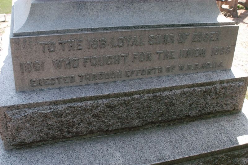
To the 186 loyal sons of Essex
1861 who fought for the Union. 1865
Erected through the efforts of W.R.C. No. 114.
Antietam • Wilderness • Cedar Creek
Appomattox • Ressaca • Port Hudson • Gettysburg
New Orleans • Mobile • Fort . . . — — Map (db m97211) WM
A free school for Chebacco
parish was opened in an
upper room of this house in
1695 by the appointed master,
Nathaniel Rust, Junior. The town
gave "Six acres of pasture land
for the benefit of the school
and one-quarter acre for
Mr. Rust's . . . — — Map (db m47496) HM
In memory of Herbert Goodhue who died in the service of his country Born June 15, 1914 Died May 13, 1942 In the Philippine Islands Dedicated May 30 1949 — — Map (db m97209) WM
Erected in 1701 by John Wise, pastor of the Chebacco parish of Ipswich, now Essex. Son of a laborer, Harvard graduate, army chaplain, protestant against taxation without representation and against the witchcraft delusion, defender of democracy in . . . — — Map (db m47955) HM
Sp4 Paul D. Knowlton HHC 4 Trans. Co June 2, 1947 Feb 24, 1968 PFC Robert E. Moore Com 7 Mar I Mar Div Feb 16 1948 Nov 2, 1967 To all who come to use these grounds, take a moment to remember two young boys that played on these very fields when their . . . — — Map (db m97214) WM
Dedicated to the those men of Chebacco and Essex who by the skill of mind and hand within sight of this spot created nearly 4000 wooden vessels 1650-1982 — — Map (db m97208) HM
In 1668 the town granted the
adjacent acre of land "To the
inhabitants of Ipswich for a yard
to build vessels and to employ
workmen for that end."
The shipbuilding industry has
continued uninterruptedly in
Essex since that date. — — Map (db m47495) HM
From this spot, you look out to the Castle’s Neck River, a meandering seven-mile tributary that is part of the Great Marsh ecosystem. The Great Marsh is the largest salt marsh in New England and includes over 25,000 acres of spectacular coastal . . . — — Map (db m254136) HM
From a large bark or packet ship 200 to 300 feet long, lost at sea. Salvaged by Captain Salvatore Zappa and crew of the fishing vessel Carol Ann in 1988. — — Map (db m193088) HM
The eminent artist, Anna Vaughn Hyatt Huntington, had Gloucester roots and French ties. In 1910 when Huntington first entered a life-sized plaster of Joan of Arc into a Paris Salon competition, she found that some of the judges doubted that she . . . — — Map (db m245589) HM
Blynman Bridge
1907
In Honor Of
Richard Blynman
First Minister and Leading Citizen
Of Gloucester
Who in 1643 Dug This
Canal Uniting River and Bay
G.H.S. — — Map (db m36363) HM
Cape Ann lies on an outcropping composed of 450 million-year-old granite polished by glaciers. This particularly dense stone was prized for building monuments, forts, and piers. Blocks of Cape Ann granite were used to build Gloucester's Dale . . . — — Map (db m115434) HM
On this site in 1623
A company of fishermen and farmers from Dorchester England under the direction of Rev. John White founded the Massachusetts Bay Colony From that time the fisheries the oldest industry in the commonwealth has been . . . — — Map (db m85296) HM
The first man to sail single
handed from west to east
across the Atlantic Ocean.
A typical Banks dory decked
over, christened Centennial to
commemorate the first centennial
of the founding of the
United States, 1776 . . . — — Map (db m115475) HM
Citizen of Gloucester,
crossed the Atlantic twice,
alone, without any fingers
or toes and part of one foot
missing, all frozen in an
accident at sea.
On June 18, 1899, sailed from
Gloucester, Mass. To
Gloucester, England, on . . . — — Map (db m115478) HM
Charles Heberle (1862-1956) was sent at age 13 from Virginia to Essex, where for three years he was indentured to the Essex Tannery. Once free, he worked nearby for a dairy farmer, Caleb Cogswell.
Soon, Heberle chose waterfront over farm and . . . — — Map (db m115439) HM
This Circle
Erected by The
Commonwealth
of
Massachusetts
1956
Is Dedicated to Honor
Chester H. Grant
1897 – 1954
A soldier and devoted citizen who faithfully served his community, state and nation in war and in peace.
A . . . — — Map (db m36316) HM
In Honor of the Men Who Established Coast Guard Aviation
In May of 1925 On
Ten Pound Island in Gloucester Harbor
Home of the First Continuously Operating Coast Guard Air Station
Growth in Operations and Aircraft Size Forced a Move
To Salem . . . — — Map (db m36437) HM
Born on Middle Street, business theorist and investor Roger Babson hired unemployed stone cutters to inscribe more than two-dozen boulders during the Depression. He hoped that words such as "industry," "initiative," and "integrity" would inspire . . . — — Map (db m115460) HM
This bell was used as the fog signal at Eastern Point Light House from June 1933 to Dec 1969.
Cast in Chelsea, MA. gold dust was sprinkled in the mold in order to obtain the right tone. — — Map (db m115484) HM
For nearly four centuries the history of Gloucester has been the story of America's greatest fishing port. With this memorial we commemorate the lives and the legacy of those who died at sea while fishing.
The first settlers came from England . . . — — Map (db m156491) HM
Gloucester Fisherman's Wives Memorial
Dedicated By The
Gloucester Fisherman's Wives Association
August 5, 2001
[ inscription around the base of the sculpture ]
The Wives, Mothers, Daughters and Sisters of Gloucester Fisherman . . . — — Map (db m36359) HM
[ bay side ]
In Memory Of
Korean Veterans
June 27 1950 – Jan 31 1955
Dedicated In 1980
By The Citizens Of
Gloucester
[ land side ]
In Memory Of
Vietnam Veterans
Aug 5 1964 – May 7 1975
Dedicated In . . . — — Map (db m36435) WM
North facing, front side
G. Co. Eighth Regiment Massachusetts Infantry, U.S. Vols.
Reviewed by General Maximo Gomez
at Matanzas, Cuba, February 20, 1899
Gloucester's sons, one hundred strong
answered the nation's call to arms . . . — — Map (db m75261) WM
[ inscribed around the base of the globe ]
We Fought For Freedom Around The World
[ plaque on central column ]
Gloucester
Remembers
1941 – World War II – 1945
The people of Gloucester proudly dedicate this . . . — — Map (db m36768) HM
James Babson
Farm
Granted by Special Town Act December 23, 1658
James and his mother Isabel were the first Babsons to reach America, arriving in 1632.
James' father died on shipboard while crossong.
-----------------
Town records show . . . — — Map (db m36302) HM
[ upper plaque ]
In Memory of those who fought in the Revolutionary War with the Nathaniel Warner Company and those men and women who helped make this a free and independent nation.
Placed by the reactivated
Nathaniel Warner . . . — — Map (db m36354) HM
Welcome to Oak Grove Cemetery
The Oak Grove Cemetery was founded in 1854 by six local businessman: Benjamin Hough, Jr., Edward Babson, Epes Merchant, Frederick Norwood, Herman Davison, and Eben Stacy. The intention of the founders was to create a . . . — — Map (db m250792) HM
Here in 1630-31 a company from Plymouth, under Abraham Robinson, established a fishing station
and built curing stages. For nearly two centuries and a half Annisquam was a fishing and ship-building center. — — Map (db m48615) HM
Used by a 500 ton 3-masted sailing ship, 150 ft in length. Salvaged by Capt. Frank Santuccio of the Fishing Vessel Blue Waters on Nov. 22nd, 1963. — — Map (db m193089) HM
Erected by Roger W. Babson in honor of his ancestor Reverend John Rogers burned at the stake February 4, 1555 in London for translating the Bible into English and preaching the Eighth Chapter of Deuteronomy. — — Map (db m243072) HM
In memory of the soldiers and sailors and all others who rendered aid to the cause of American Independence during the Revolutionary War
Erected by Lucy Knox Chapter Daughters of the American Revolution of Gloucester
June 17, 1913 — — Map (db m36356) HM
[South Side of Marker]
Riverdale
Martyrs
In the War
Of the Rebellion.
1861-1865
[East Side of Marker]
Serg – Benj. H. Griffin, C. 23d Mass.
Addison Griffin, I. 23d Mass.
Abraham Day, Jr. G. 23d Mass. . . . — — Map (db m24020) HM
[ front ]
Honor Roll
-----------
In Honor
Of Those
Who
Answered
Their
Country's
Call
[ plaque on back ]
Riverdale
Honors Her Sons and Daughters
Who Served
In World War II
Meyer Abrahams • Sidney Abrahams . . . — — Map (db m36441) HM
“There were no galleries in those days and no one ever expected to sell a picture, so you weren’t interested in making it. You were only interested in actually being a good artist… And, of course, you didn’t need as much money. I remember . . . — — Map (db m115465) HM
“In Its heyday as a salt fish producer; Gorton's… kept dozens of wharves and acres of flake yards busy with the unloading, filleting, salting, drying, boning, cutting, grinding, smoking, boxing, packaging, and canning of the millions upon . . . — — Map (db m115459) HM
In September, 1606, Samuel de Champlain landed at Rocky Neck in what is now Gloucester Harbor, to caulk his shallop, and made an accurate chart of the harbor which he called Le Beauport. — — Map (db m274809) HM
Samuel Sawyer was a great Gloucester philanthropist. A very successful ship owner and merchant, Mr. Sawyer donated Gloucester's City Hall clock and bell. He bought up woodlots to preserve the 600-acre Ravenswood Park. He founded the City's first . . . — — Map (db m115426) HM
On this site in 1623 the Dorchester Adventurers founded the nucleus of the Massachusetts Bay Colony, and fishing industry. Here Roger Conant averted bloodshed between two factions contending for a fishing stage, a notable example of arbitration in . . . — — Map (db m274831) HM
"King of the Mackerel Killers"
Solomon Jacobs Landing & Park were named for Captain Solomon Jacobs, who fished in the early 1900s.
A native of Newfoundland, he was known as the "King of the Mackerel Killers" for his ability to land huge . . . — — Map (db m115472) HM
Stacy Esplanade
Is the Result of a Wish Conceived By
His Parents and Fulfilled by Their Son
George O. Stacy
Keenly Alive to the Beauty Of
Gloucester Harbor
He Desired to Bring to Its Shores A
Corresponding Beauty
This Tablet is a . . . — — Map (db m36360) HM
Oldest Defenses in the Mass. Bay Colony. Thrown up in 1625 by Capt. John Hewest. Occupied in King Philips War 1675 and in King Georges War 1743. Companies under Capt. John McCaw and Capt. John Lane stationed here during War for Independence . . . — — Map (db m36355) HM
Before you stretches Ten Pound Island. In 1821 a lighthouse was built on the island to safely direct sailing ships into Gloucester Harbor. Some of America's greatest works of art were painted by Winslow Homer while staying at the keeper's house in . . . — — Map (db m36436) HM
In Honor
Of Those Who Served
In World War II
From Ward Seven
These Our Dead From
Ward 7, WW II
Robert J. Hodgen A.F. • Robert W. Seppala A.F. • William Lee M.M. • John A. Filfalt M.M. • James M. Tarr M.M. • Roy M. Nickerson . . . — — Map (db m36440) HM
On August 8, 1775, the HMS Falcon, commanded by British Captain John Linzee, captured a schooner from Hispaniola bound for Salem. A second schooner sailing in company with the first made its escape into Gloucester Harbor. The
Falcon pursued it into . . . — — Map (db m266666) HM
Named from a bear caught by the tide and killed in 1700. Commercial and shipbuilding center of Rockport for 160 years. First dock built here 1743. Sandy Bay Pier Company organized 1809. Site of Stone Fort and Sea Fencibles Barrack during War of 1812. — — Map (db m48007) HM
Answering a sudden alarm to meet at the house of Lieutenant Benjamin Tarr, grandson of Richard Tarr the first settler, sixty-six men from this village under Captain John Rowe, marched to Charlestown and fought in the Battle of Bunker Hill. — — Map (db m73109) HM
This Cannon from The
U.S.S. Constitution
"Old Ironsides" Was
Presented to the Sandy
Bay Historical Society
By Descendants of The
First Settler, Richard
Tarr, and Dedicated
August 20, 1931 — — Map (db m36255) HM
The Project
This is the bell from the steeple of the First Congregational Church of Rockport. It is the bell that is rung hourly by the Town Clock, still owned by the Town of Rockport. It is also rung by means of a rope and bell wheel on . . . — — Map (db m115529) HM
Here stood the cabin of Richard Tarr founder of the Tarr Family on Cape Ann. He came to Marblehead in 1680, then settled in Sacco, Maine. Driven thence by Indians, he became the first settler of Sandy Bay (Rockport) in 1690. — — Map (db m48008) HM
Here stood the first framed house in Sandy Bay (Rockport) built in 1700 by the second settler John Pool. He built the first sawmill, bridge and vessel in this settlement, and furnished the lumber used in building Long Wharf, Boston, in 1710. — — Map (db m48842) HM
Original plot given by the first settler, Richard Tarr, who was buried here in 1732. Here lie most of the early settlers and many of the officers and soldiers of the French and Indian, Revolutionary and 1812 Wars. — — Map (db m48841) HM
Site of fort erected by public subscription as a protection againat British warships during the War of 1812, captured in a sneak attack and dismantled by frigate Nymphe. Ammunition gone, all nine seafencibles taken prisoner, the townsmen hurled . . . — — Map (db m36300) HM
These Our Dead In Honored Glory Rest
World War I
1917 1918
James E. Bryan R.C.A.
John A. Carlson U.S.A.
Dwight P. Dutton U.S.M.C.
Edward R. Everett U.S.A.
Harold T. Grover U.S.A.
Edward Peterson U.S.A.
World War II
1941 . . . — — Map (db m36282) HM
Due east from here on July 16 1605 the Sieur De Monts sent Samuel De Champlain ashore to parley with some Indians. They danced for him and traced an outline map of Massachusetts Bay. These French explorers named this promontory, The Cape of Islands. — — Map (db m74709) HM
Straitsmouth Island was first sighted in 1614 by Captain John Smith. He also spotted nearby Thacher and Milk Islands and named all three the Turks' Heads.
Lighting the Way
Built in 1834, the island's first lighthouse was 19 feet . . . — — Map (db m115515) HM
To the glory of God and in honor of the first settlers of Sandy Bay
The First Parish in Rockport was constituted in 1755. The corner stone of this meeting house laid in 1803. The tower was shattered by a British bombardment in 1814. . . . — — Map (db m73110) HM
Town Wharves
First timber wharf built in 1743 to shelter fishing boats. In 1793 62 vessels of 5 to 10 tons were sighted in Rockport Harbor. From incorporation of Sandy Bay Pier Co. in 1811 wharves were rebuilt and extended of durable granite blocks . . . — — Map (db m36262) HM