45 entries match your criteria.
Related Historical Markers
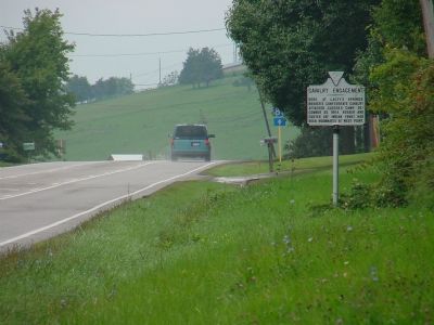
By J. J. Prats, September 28, 2006
Cavalry Engagement Marker
SHOWN IN SOURCE-SPECIFIED ORDER
| 1 ► Virginia, Rockingham County, Lacey Springs — A-29 — Cavalry Engagement — |
| On North Valley Pike (U.S. 11) south of Martz Road. | |||
| 2 ► Virginia, Rockingham County, Lacey Springs — A-18 — Abraham Lincoln’s Father — |
| On Valley Pike (U.S. 11) north of Lacey Spring Road, on the left when traveling south. | |||
| 3 ► Virginia, Rockingham County, Elkton — Miller-Argabright-Cover-Kite House — Stonewall Jackson’s Headquarters, April 19-30, 1862 — 1862 Valley Campaign — |
| On East Rockingham Street, 0.1 miles east of Stuart Avenue / East Side Highway (U.S. 340), on the right when traveling east. | |||
| 4 ► Virginia, Harrisonburg — A-35 — End of the Campaign — |
| On South Main Street (U.S. 11) south of Monument Avenue, on the right when traveling south. | |||
| 5 ► Virginia, Rockingham County, Elkton — Jennings House — Confederate Hospital — |
| On West Rockingham Street near West Spotswood Trail (Business U.S. 33), on the left when traveling west. | |||
| 6 ► Virginia, Rockingham County, Lynnwood — 4 — Port Republic — Struggle for the "Coaling" — |
| On Ore Bank Road (Virginia Route 708) near Mapleton Lane (County Route 967). | |||
| 7 ► Virginia, Rockingham County, Lynnwood — 1 — Port Republic — Last Battle of Jackson’s 1862 Valley Campaign — |
| On Ore Bank Road (Virginia Route 708) at Mapleton Lane (County Route 967) on Ore Bank Road. | |||
| 8 ► Virginia, Rockingham County, Lynnwood — JD-10 — Battle of Port Republic — |
| On South East Side Highway (U.S. 340) at Ore Bank Road / Lynnwood Road (Virginia Route 708), on the right when traveling east on South East Side Highway. | |||
| 9 ► Virginia, Rockingham County, Penn Laird — D-6 — Battle of Cross Keys |
| On Spotswood Trail (U.S. 33) west of Cross Keys Road (Virginia Route 276), on the right when traveling west. Reported missing. | |||
| 10 ► Virginia, Rockingham County, Cross Keys — Cross Keys Battlefield — |
| On Port Republic Road (County Route 659) south of Cross Keys Road (Virginia Route 276), on the right when traveling south. | |||
| 11 ► Virginia, Rockingham County, Dayton — Lt. Col. Thomas F. Wildes — |
| On Main Street (Business Virginia Route 42) at Mill Street, on the right when traveling south on Main Street. | |||
| 12 ► Virginia, Rockingham County, Mount Crawford — A-32 — Sheridan's Last Raid — |
| On South Main Street (U.S. 11), on the left when traveling south. | |||
| 13 ► Virginia, Rockingham County, Port Republic — Palmer Lot at Middle Ford — Ford was site of Jackson’s temporary bridge — |
| On Water Street, 0.1 miles west of Port Republic Road (County Route 659), on the left when traveling west. | |||
| 14 ► Virginia, Rockingham County, Port Republic — Madison Hall — Homesite scene of colonial settlement, Civil War clash — |
| On Main Street, 0.1 miles south of Leroy Road, on the left when traveling north. | |||
| 15 ► Virginia, Harrisonburg — General Turner Ashby of Fauquier — |
| On South Main Street (U.S. 11) at Port Republic Road, on the right when traveling north on South Main Street. | |||
| 16 ► Virginia, Rockingham County, Lynnwood — Port Republic Battlefield — |
| On Ore Bank Road (Virginia Route 708) at Mapleton Lane, on the left when traveling east on Ore Bank Road. | |||
| 17 ► Virginia, Rockingham County, Lynnwood — Battle of Port Republic — June 9, 1862 — |
| On East Side Highway South (U.S. 340) 0.4 miles south of Jackson Way (Virginia Route 955), on the right when traveling south. | |||
| 18 ► Virginia, Rockingham County, Dayton — Death of Lt. Meigs — Deadly Encounter — 1864 Valley Campaigns — |
| On Meigs Lane, 0.1 miles east of John Wayland Highway (Virginia Route 42), on the left when traveling east. | |||
| 19 ► Virginia, Rockingham County, Dayton — Death of Lt. Meigs — The Heavy Hand of War — 1864 Valley Campaigns — |
| On Meigs Lane, 0.1 miles east of John Wayland Highway (Virginia Route 42), on the left when traveling east. | |||
| 20 ► Virginia, Rockingham County, Dayton — Site Where Lt. John Rodgers Meigs Was Killed — |
| On Meigs Lane, 0.1 miles east of John Wayland Highway, on the left when traveling east. | |||
| 21 ► Virginia, Rockingham County, Broadway — Elder John Kline Monument — |
| On Pratt Lane, on the right when traveling west. | |||
| 22 ► Virginia, Rockingham County, Linville — KB-65 — Lincoln's Virginia Ancestors — |
| On Harpine Highway (State Highway 42), on the right when traveling north. | |||
| 23 ► Virginia, Harrisonburg — Chestnut Ridge — Death of Ashby — 1862 Valley Campaign — |
| Near Turner Ashby Lane, 0.2 miles north of Neff Avenue. | |||
| 24 ► Virginia, Rockingham County, Port Republic — North River Bridge — Covered bridge instrumental in Valley Campaign — |
| On Route 1602, on the right when traveling east. | |||
| 25 ► Virginia, Rockingham County, Cross Keys — The Battle of Cross Keys — “It was not in men to stand such fire as that.” — 1862 Valley Campaign — |
| On Battlefield Road (Route 679) 0.1 miles south of Cross Keys Road (Virginia Route 276), on the right when traveling east. | |||
| 26 ► Virginia, Rockingham County, Cross Keys — Battle of Cross Keys — Slaughter of the 8th New York Infantry — 1862 Valley Campaign — |
| Near Port Republic Road (Route 659), on the right when traveling south. | |||
| 27 ► Virginia, Rockingham County, Cross Keys — Battle of Cross Keys — The Civilians of Cross Keys — 1862 Valley Campaign |
| On Port Republic Road (County Route 659) south of Cross Keys Road (Virginia Route 276), on the right when traveling south. Reported missing. | |||
| 28 ► Virginia, Rockingham County, Cross Keys — Battle of Cross Keys — Southern Artillery — 1862 Valley Campaign |
| On Port Republic Road (County Route 659) south of Cross Keys Road (Virginia Route 276), on the right when traveling south. Reported missing. | |||
| 29 ► Virginia, Rockingham County, Cross Keys — Battle of Cross Keys — Duel Attacks — 1862 Valley Campaign |
| On Port Republic Road (County Route 659) south of Cross Keys Road (Virginia Route 276), on the right when traveling south. Reported missing. | |||
| 30 ► Virginia, Rockingham County, Cross Keys — Battle of Cross Keys — Immigrant Soldiers — 1862 Valley Campaign — |
| Near Goods Mill Road (Route 708), on the right when traveling south. | |||
| 31 ► Virginia, Rockingham County, Cross Keys — Battle of Cross Keys — Trimble’s Ravine — 1862 Valley Campaign — |
| Near Goods Mill Road (County Route 708), on the right when traveling south. | |||
| 32 ► Virginia, Rockingham County, Cross Keys — Mill Creek Church — War Strikes Peaceful Homes and Fields — |
| On Port Republic Road (Route 659), on the right when traveling east. | |||
| 33 ► Virginia, Rockingham County, Cross Keys — Battle of Cross Keys — Walker’s Flank Attack — 1862 Valley Campaign — |
| Near Goods Mill Road (County Route 708), on the right when traveling south. | |||
| 34 ► Virginia, Rockingham County, Bridgewater — Bridgewater — Bridgewater During the War — |
| On West Riverside Drive (State Highway 42). | |||
| 35 ► Virginia, Rockingham County, Bridgewater — Bridgewater — Historic North River Crossing — |
| On West Riverside Drive (State Highway 42). | |||
| 36 ► Virginia, Rockingham County, Dayton — Dayton — Dark Days in the Burnt District — |
| On John Wayland Highway (Route 42), on the left when traveling north. | |||
| 37 ► Virginia, Rockingham County, Dayton — Daniel Bowman Mill at Silver Lake — Shenandoah Valley Mills — |
| On Silver Lake Road (County Route 701) at Linhoss Road, on the left when traveling north on Silver Lake Road. | |||
| 38 ► Virginia, Harrisonburg — Warren-Sipe House — Home and Hospital |
| On South Main Street (Business U.S. 11), on the left when traveling north. Reported permanently removed. | |||
| 39 ► Virginia, Harrisonburg — Court Square & Springhouse — Temporary Prison Camp — |
| On Main Street (Business U.S. 11), on the left when traveling north. | |||
| 40 ► Virginia, Rockingham County, Bridgewater — Famous Travelers Along the Turnpike — |
| On North Main Street (State Highway 42), on the right when traveling north. | |||
| 41 ► Virginia, Harrisonburg — The Woodbine Cemetery — |
| On East Market Street (U.S. 33), on the left. | |||
| 42 ► Virginia, Harrisonburg — Confederate Monument — |
| On East Market Street (U.S. 33), on the left when traveling west. | |||
| 43 ► Virginia, Harrisonburg — A-30 — Where Ashby Fell — |
| On South Main Street (Business U.S. 11), on the right when traveling north. | |||
| 44 ► Virginia, Rockingham County, Port Republic — The Frank Kemper House — Thriving river community was transportation hub |
| On Water Street, on the left when traveling north. Reported missing. | |||
| 45 ► Virginia, Harrisonburg — Hardesty-Higgins House — Banks's Headquarters — |
| On South Main Street (Business U.S. 11) south of East Bruce Street, on the right when traveling north. | |||