3231 entries match your criteria. Entries 201 through 300 are listed.⊲ Previous 100 — Next 100 ⊳
Daughters of the American Revolution Historical Markers
Markers erected by all chapters of the Daughters of the American Revolution (DAR). DAR is dedicated to historical preservation, accomplished by the efforts of its chapters at the local level. One of the ways they accomplish this is by placing monuments around the world to memorialize people and events throughout American history.
The series also includes other markers that mention DAR where DAR is not the erecting organization, where a DAR marker is nearby or where an additional photo of a DAR tablet or plaque is included in the page but it does not include enough information to be considered a marker in its own right.
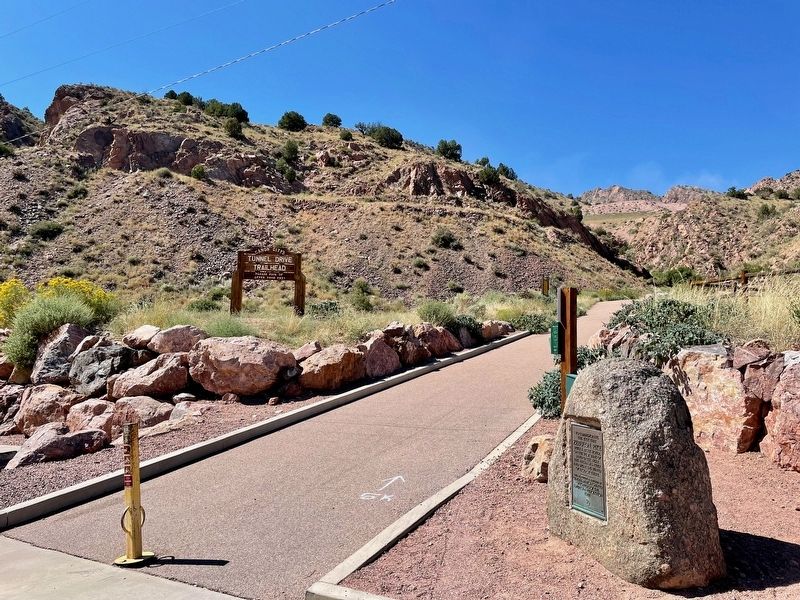
By Mark Hilton, September 5, 2023
Zebulon Pike Block House Marker at the Tunnel Drive Trail Head.
On Tunnel Drive, 0.6 miles west of U.S. 50, on the right when traveling west.
To commemorate
the fact that
Zebulon Pike
built a block house
on the west bank of
Sand Creek near
the Arkansas River
and spent the winter
of 1806-07 there — — Map (db m232221) HM
On Tomichi Avenue (U.S. 50) at Adams Street, on the right when traveling east on Tomichi Avenue.
This sign was place[d] on Monarch Pass
in 1916 by the DAR to commemorate
the Gunnison Country's abundance
of rainbow trout in the Gunnison River.
————————————— . . . — — Map (db m158558) HM
This Tablet is the property of the State of Colorado
————
From 1862 to 1867
Golden was the Territorial
Capital of Colorado
Legislative sessions were held in this building (erected by W.A.H. . . . — — Map (db m39337) HM
On County Highway 250, 0.5 miles east of U.S. 550, on the left when traveling east.
Captain Charles H. Baker, who discovered gold in the San Juan in 1860, led a party of prospectors to this area in 1861. They placer mined on El Rio de las Animas, built the first bridge (300 feet north), and established the town called Animas . . . — — Map (db m177471) HM
On State Highway 91, on the right when traveling south.
This memorial is the
Property of the State of Colorado
Fremont Pass
On Continental Divide between
Arkansas and Blue River drainages
Altitude 11,316 feet
Western boundary of the Louisiana
Purchase of 1803.
Named . . . — — Map (db m128033) HM
On South Saint Varain Avenue (State Highway 7), on the right when traveling north.
Father of the Rocky Mountain National Park
internationally known naturalist, author, lecturer and nature guide
Homesteaded on this site in 1885. — — Map (db m78715) HM
Near Bingham Hill Rd, 0.1 miles west of North Overland Trail Rd (County Road 21C), on the right when traveling west.
Lest we forget.
Bingham Hill Historic Cemetery, 1862.
Reserved by John B. Provost and Ben Claymore (aka L.B. Lessert), 1979.
Dedicated in memory of all those known and unknown ever buried here.
Placed by Cache la Poudre . . . — — Map (db m173608) HM
On Overland Trail, 0 miles south of US 287B Highway, on the right when traveling north.
This log house was built by French trader Sam Deon in 1858. Purchased by Civil War Veteran John Wesley Tharp in 1877. From 1877-1937 the home of Eliza Bingham Tharp Gardner. From 1937-1985 the property of Ethel Gardner Ames Holtz. Now belongs to . . . — — Map (db m174426) HM
On Red Feather Lakes Rd (County Road 74E at milepost 16) at Boy Scout Rd (County Road 68C), on the right when traveling south on Red Feather Lakes Rd.
A stage station, post office, and hotel, on the route from Fort Collins, by way of Pingree Hill, to Home, Colorado, in the upper Poudre Canyon.
In memory of Mildred Payson Beatty — — Map (db m173076) HM
On N County Road 19E, on the right when traveling north.
This Memorial Is the
Property Of The State Of Colorado
Namaqua
Home, trading post and fort of
Mariano Modena, early trapper,
scout and pioneer.
First settlement in the
Big Thompson Valley.
Station on Overland . . . — — Map (db m51194) HM
This monument
marks the route of the
Santa Fe Trail
1822 - 1879
placed by the
Daughters of the
American Revolution
and the
State of Colorado
It also commemorates
the faithful work of
Harriett Parker Campbell . . . — — Map (db m77856) HM
This tablet commemorates the establishment of the first public school in the Sterling settlement, October, 1875. It was taught by Carrie G. Ayres, later Mrs. J. N. Hall of Denver. The sod schoolhouse stood 3160 feet east and the sod fort built by . . . — — Map (db m51221) HM
On Grand Army of the Republic Highway (State Highway 6) at County Road 22 on Grand Army of the Republic Highway.
This tablet is erected in honor of
William Shaw Hadfield
The first white settler of Logan County, marking the site of his first sod house at Hadfield Island in 1871, three-fourths mile east.
Erected by the wife
Margaret Seibert . . . — — Map (db m61996) HM
On Main Street east of South 4th Street, on the right when traveling east.
Upon this site in October 1882
a vital cultural influence in the town
of Grand Junction was established by
the printing of the first newspaper ~
The Grand Junction News
Edwin Price, Editor — — Map (db m120052) HM
Occupied from 1864 to 1868 and the divergence of the Denver Cut Off from the Overland Trail
This monument is erected by Fort Morgan Chapter, Daughters of the American Revolution
1912 — — Map (db m51213) HM
On Colorado 194, 0.1 miles east of County Road 35, on the right when traveling east.
Erected at the request of the Daughters of the American Revolution 1910 by A.E. Reynolds
Bent's Fort Santa Fe Trail as shown by ruins of walls in 1909
1822 The Santa Fe Trail 1875
This stone marks the point of the trail where the . . . — — Map (db m192004) HM
On Main Street (U.S. 50) at E. Beech Street, on the right when traveling north on Main Street.
(Front Panel)
N.S.D.A.R. Memorial
to the
Pioneer Mothers
of the
Covered Wagon Days
(Right Side Panel)
A place of historical lore noted for Indian lodges; shelter from storm and heat; food supply for beast; bivouac . . . — — Map (db m106897) HM
Near Scenic U.S. 50/287 at State Highway 196, on the right when traveling west.
The Story Begins… in 1922 when Mrs. John Trigg Moss representing the National Society of the Daughters of the American Revolution and Harry Truman joined forces to petition Congress to designate a "National Old Trails Road," . . . — — Map (db m213698) HM
On West 1st Street at Court Street, on the right when traveling west on West 1st Street.
This memorial commemorating the Old Pueblo Fort Site erected by The Arkansas Valley & Pueblo Chapters, Daughters of the American Revolution. Dedicated Nov. 17, 1923.
On Christmas Day, 1854, a massacre occurred at Fort Pueblo on the . . . — — Map (db m64755) HM
On South Joplin Avenue (State Highway 227) at Damson Street, on the right when traveling south on South Joplin Avenue.
This tablet is the
Property of the State of Colorado
——
The hill one block east is
Jacob Fowler's Lookout.
Later called Sugar Loaf Hill.
Near it in a log house Fowler
and his trappers . . . — — Map (db m96053) HM
On Lane 36 (State Highway 231) at Santa Fe Drive (U.S. 50), on the left when traveling north on Lane 36.
By 1700 Comanches moved south from the northern Rockies onto the plains of southern Colorado and northern New Mexico. They raided the Apaches and Spanish settlements from the late 1600s until 1779 when the Governor of New Mexico, Don Juan Bautista . . . — — Map (db m64775) HM
On 14th Avenue at 13th Street, on the right when traveling north on 14th Avenue.
Water entered this #3 Ditch, 9 miles long,
June 10, 1870. March 13, 1875 Union Colony deeded
to the town of Greeley water supplied by Ditch #3
for the sum of $488.00.
In 1882 this ditch was deeded to the Greeley
Irrigation Company . . . — — Map (db m119613) HM
On Colorado Route 257 west of West 10th Street (Business U.S. 34), on the right when traveling west.
These pillars mark the spot where 2,000 German soldiers were incarcerated for security reasons in the last years of World War II.
The first occupants of this 320 acre camp, surrounded by tall barbed wire fences, were
German-Austrian . . . — — Map (db m120527) HM
On Old Post Road at Beach Road, on the left when traveling south on Old Post Road.
This boulder commemorates
the settlement of Fairfield
by Roger Ludlow in 1639
and the burning of the Town
by the British July 8, 1779.
From the founding of the Town
the religious, military and civic life
of the people
has centered . . . — — Map (db m27227) HM
On Beach Road at Sunnieholm Drive, on the left when traveling west on Beach Road.
1775 1783
In everlasting memory
of the Patriots and Soldiers of
Fairfield who served in the War
of the American Revolution
———
Erected by the Eunice Dennie Burr Chapter
Daughters of the American Revolution
A.D. . . . — — Map (db m27171) HM
On Bronson Avenue, 0.1 miles north of Verna Hill Road, on the right when traveling north.
In Memory Of The
Men Of Greenfield Hill
Who Fought In
The American Revolution
John Alvord • Benjamin Banks 4th • Daniel Banks • David Banks • Ebenezer Banks Esq. • Ebenezer Banks • Elijah Banks • Eliphalet Banks • Gershom Banks • Gershom . . . — — Map (db m27420) HM
On East Putnam Avenue (U.S. 1) at Old Church Road, on the left when traveling north on East Putnam Avenue.
This Marks The Spot
Where On February 26, 1779
General Israel Putnam,
Cut Off From His Soldiers And
Pursued By British Cavalry,
Galloped Down This Rocky Steep
And Escaped, Daring To Lead Where Not
One Of Many Hundred Foes Dared To . . . — — Map (db m38607) HM
On Church Hill Road (U.S. 6) at Queen Street, on the right when traveling east on Church Hill Road.
1732 ---- 1932
In Commemoration Of
The Two Hundredth Birthday Of
George Washington
----
Rochambeau
Established a Camp Here
June 28 To July 1, 1781
----
Soldiers Commanded By
Lafayette
Camped At This Spot
Placed by Mary . . . — — Map (db m26914) HM
On France Street at Adams Avenue, on the left when traveling north on France Street.
On this historic ground the American Patriots bravely sustained the cause of Liberty against the British Invaders July 12, 1779 ---------- Erected by the D.A.R. of Norwalk 1894. — — Map (db m53435) HM
On East Avenue, on the right when traveling north.
From the summit of this hill Maj. Gen. William Tryon witnessed the Burning of Norwalk by the British troops under his command during the engagement of July 11 & 12, 1779. --------------- Erected by Norwalk Chapter Daughters of the American . . . — — Map (db m53434) HM
On Atlantic Street at Main Street, on the right when traveling north on Atlantic Street.
This tablet has been placed by Stamford Chapter National Society Daughters of the American Revolution to commemorate
The Settlement of Stamford in 1641
During that year, twenty nine men and their families came from Wethersfield to this place. . . . — — Map (db m38609) HM
On Westover Road, on the right when traveling south.
To mark the site near by of Fort Stamford Built and garrisoned for the defense of the people in these parts in the War for American Independence Erected by Stamford Chapter Daughters of the American Revolution Sept. 14, A.D. 1926 < Lower . . . — — Map (db m53431) HM
[Left Plaque]
In honor of
the men and women
who planted in the wilderness
the early homes of Stratford,
who fought bravely and suffered patiently
in the War of the American Revolution,
and who left to their descendents
a . . . — — Map (db m26099) HM
On Memorial Boulevard, 0.2 miles east of East Street, on the right when traveling west.
In Memory Of The
Revolutionary War Patriots
Who Sacrificed Their Lives
And Fortune For Their Country
Placed By
Katherine Gaylord Chapter
Daughters Of The American Revolution
1964 — — Map (db m221637) HM
On Bellevue Avenue at Queen Street, on the right when traveling north on Bellevue Avenue.
New Cambridge (now Bristol)
Was Settled 1727 – 8
Since Early Days
The Federal Hill Green
Has Been Used As A
Training Ground For Soldiers And A
Playground For Children
This Boulder Was Placed
By Katherine Gaylord Chapter . . . — — Map (db m34240) HM
On Albany Turnpike (U.S. 44), on the right when traveling west.
On this site, in 1778, Phoebe Humphrey protected
her home from Hessian soldiers who were part of
Burgoyne’s captured army headed for Boston.
Because of her bravery, she became the namesake
of the Collinsville Chapter of the National Society
of . . . — — Map (db m94480) HM
On Enfield Street at Spier Avenue, on the left when traveling south on Enfield Street.
Near this site the first church building in Enfield was erected by pioneer settlers in 1684.
Placed by Penelope Terry Abbey Chapter, D.A.R.
1680 1930 — — Map (db m113886) HM
On Enfield Street at Spier Avenue, on the left when traveling south on Enfield Street.
To Honor the Memory of the Founders of the Town of Enfield. Who led by John Pease, Jr. and his Brother Robert made the First Settlement in 1680.
Placed by Penelope Terry Abbey Chapter, D.A.R.
1680 1930 — — Map (db m113885) HM
On Main Street at Gold Street, on the right when traveling north on Main Street.
George Washington
was entertained by
Colonel Jeremiah Wadsworth in his home on this site on June 30, 1775 when on his way to Cambridge to assume command of the Army.
On September 21, 22, 23, 1780 with Lafayette, General Knox and Governor . . . — — Map (db m151930) HM
Near Central Row near Main Street, on the right when traveling west.
In 1636
The Church in Newtown, Massachusetts
Thomas Hooker, Minister
was transplanted to this locality, called
Meeting House Yard,
Old State House Square
City Hall Square.
Near this site on May 31, 1638.
Thomas Hooker preached his . . . — — Map (db m52695) HM
On East Street, 0.1 miles south of Allen Street, on the right when traveling south.
About Thirty Feet from this Spot
Stood the House in Which
Brig. Gen. John Patterson
Was Born in 1743 - 4
Member of two Provincial
Congresses from Lenox Mass.
Leader in the War of Independence
Distinguished Jurist and Member of . . . — — Map (db m41611) HM
On Eddy Glover Boulevard at Commonwealth Avenue, on the right when traveling north on Eddy Glover Boulevard.
In Commemoration Of The
Bi-Centennial Anniversary Of The Birth Of
George Washington
These Trees Are Dedicated
Thanksgiving Day, November 24, 1932
Participating Organizations
American Legion, Eddy Glover Post No. 6 • American Legion . . . — — Map (db m221828) HM
Near Old Bridge Road, 0.1 miles south of Drake Hill Road.
A toll bridge was built here
in 1734 by order of
the General Assembly
it was the first
highway bridge across
the Farmington River — — Map (db m102001) HM
Near Hopmeadow Street (Connecticut Route 10) at Station Street, on the right when traveling south.
Site Of
The First Meeting House
In Simsbury
1683 – 1739
Built at a cost of £ 33 according to an indenture between Thomas Barber and The Town
This site was chosen by lot at a solemn mmting of May 24th 1683 thus ending a controversy . . . — — Map (db m88060) HM
On Hopmeadow Street (Connecticut Route 10) at Pent Road, on the left when traveling north on Hopmeadow Street.
This Elm Tree
Dedicated in Honor of the
Bicentennial of the Birth of
George Washington
Abigail Phelps Chapter D.A.R.
February 22, 1932 — — Map (db m87951) HM
On Main Street (Connecticut Route 10) at Academy Street, on the left when traveling north on Main Street.
This Is A Constitution Oak
Presented To The
Hon. M. H. Holcomb
A Delegate To The Constitutional Convention
In Hartford 1902
Marked By
Hannah Woodruff Chapter D.A.R.
1929 — — Map (db m33713) HM
On North Main Street at Brace Road, on the right when traveling south on North Main Street.
First Public Library
Building in West Hartford
Erected as a Memorial to
Noah Webster
Presented to the Town by
Sarah Whitman Hooker Chapter
Daughters of the American Revolution
Aided by Funds Collected from Townspeople
February 27, . . . — — Map (db m53371) HM
On Palisado Ave at Bissell's Ferry Road on Palisado Ave.
This marks the road to Bissell’s Ferry, established by the General Court of Connecticut in 1641. Operated by the Bissell family for nearly one hundred years. Later leased to various townsmen and continuously operated until 1917. The original . . . — — Map (db m65727) HM
On the brow of the hill overlooking the meadow
stood the Old Stone Fort or Stoughton House. It was
in two portions, one stone, probably the older, and one wood. At the north end was a door of heavy oak
timbers studded with iron spikes, which bore . . . — — Map (db m28364) HM
The Warham Mill was established by Mr. John Warham, first minister to the Windsor Church, in 1640. The Mill has been in continuous use as a grist mill to the present day. Tradition says it was the first grist mill in Connecticut. — — Map (db m219574) HM
On East River Road, 1.7 miles south of Connecticut Route 20, on the left when traveling south.
This portion of the Peoples Forest
was given by the Connecticut
Daughters of the American Revolution
1929
Near this spot was the
site of an Indian Village — — Map (db m93827) HM
On Main Street at Church Street, on the left when traveling south on Main Street.
On the site of this building
once lived
Roger Sherman
Born 1721 – Died 1793
One of the Signers of the
Declaration of Independence — — Map (db m20922) HM
Near Main Street (Connecticut Route 63) at French Street, on the right when traveling north.
[ west side ]
To commemorate the suffering and torture inflicted by the Indians upon Jonathan Scott and Hannah Hawkes, his wife, the first permanent settlers of Watertown, this memorial is erected by the Waterbury and Watertown Chapters . . . — — Map (db m31165) HM
Near Main Street (Connecticut Route 63) at French Street, on the right when traveling north.
Revolutionary War Soldier
Michael Dayton
Captain of Connecticut
Born June 4, 1722
Died Sept. 22, 1776
Placed by
Sarah Whitman Trumbull
Chapter NSDAR May 1996 — — Map (db m31164) HM
On Main Street (Connecticut Route 63) at French Street, on the right when traveling north on Main Street.
[ marker on the left column ]
Soldiers of 1776
Ensign Theophilus Baldwin
Col. Aner Bradley
Benaja Bryan
David Buckingham
Thomas Cole
Younglove Cutler
Samuel Dayton
Dr. John Elton
Jonathan Garnsey
Capt. Joseph Garnsey . . . — — Map (db m26473) HM
On Park Place West at Grove Street, on the right when traveling south on Park Place West.
In Grateful Remembrance
Of the Soldiers of the American Revolution
Who Are Buried
In The Town Of Winchester
Stephen Wade • Ozias Bronson • Wail Loomis • John Dare • Richard Coit • Moses Hatch • Roswell Grant • Oliver Coe • Solomon Wheadon • . . . — — Map (db m29901) HM
On Torrington Road at Willow Street, on the left when traveling south on Torrington Road.
To Keep In Rememberance
The Men Of Winchester
Who Gave Their Service
Even Unto Death
For Their Country
And Her Kindred Nations
Beyond The Seas
1917 – 1918
This Tablet Is Erected
And These Oaks Stand
As A Living . . . — — Map (db m29984) HM
On St. John’s Square at St. John’s Street, on the right when traveling east on St. John’s Square.
Commodore
Thomas Macdonough
Victor at Lake Champlain
Sept. 11, 1814
Born Dec. 31, 1783 Died Nov. 10, 1825
Buried in Riverside Cemetery
Placed by Wadsworth Chapter D.A.R.
1932 — — Map (db m94209) HM
On Main Street at Water Street, on the right when traveling north on Main Street.
In observance of the U.S. Bicentennial, Elizabeth Clarke Hull Chapter NSDAR marks the site of a Charter Oak seedling given to the City of Ansonia Oct. 27, 1966, by former Mayor Frank P. Fitzpatrick
May 15, 1976 — — Map (db m25407) HM
On Wakelee Avenue at Pork Hollow Street, on the right when traveling north on Wakelee Avenue.
Pork Hollow. Near this spot where hidden military stores belonging to the army of the Revolution during Tryon’s raid through Connecticut. — — Map (db m29526) HM
On Park Street at Broad Street, on the right when traveling south on Park Street.
In Memory Of All
The Revolutionary Soldiers
Of Guilford, Connecticut.
Placed By
Agnes Dickinson Lee Chapter
Daughters Of The American Revolution
1940 — — Map (db m57224) HM
Erected in memory of all patriots of Madison (then east Guilford) who served in the War of Independence that this nation might be free. — — Map (db m243186) HM WM
On Maple Street, 0.1 miles west of North Street, on the right when traveling west.
Site of
King’s Bridge - 1711
connecting
Peacocke Lane (Maple Street)
to Governor’s Lane (Avenue)
Freelove Baldwin Stow Chapter
D.A.R.
July 4, 1962 — — Map (db m26331) HM
On Bridgeport Avenue (U.S. 1) at Concord Avenue, on the left on Bridgeport Avenue.
History of Liberty Rock
Liberty Rock as we call it today was one known as “Hog Rock”. With a little imagination, the rock appears to be in the shape of a hog. Somewhere in the rock can be found the imprint of a hog’s foot.
The . . . — — Map (db m26308) HM
Near East Main Street, on the left when traveling west.
This memorial was erected by Patriotic Citizens and Statesmen to commemorate two French Soldiers of Rochambeau's Army who volunteered to fight for American Independence under Washington, enroute from Newport to Yorktown, died and were buried here, . . . — — Map (db m36024) HM
Near Captain Thomas Blvd., 0.1 miles south of Dyke Street, on the left when traveling south.
Bradley Point Park
On July 5, 1779, British invasion forces under
the command of Brigadier General Garth
landed on this spot.
Dedicated – July 5, 1984
City of West Haven
Lawrence C. Minichino
Mayor
Plaque Donated By
The Eve . . . — — Map (db m27868) HM
On Voluntown Road (Route 138) at Old Bethel Road, on the right when traveling west on Voluntown Road.
To the Memory of
The Revolutionary Soldiers
Of Ancient Pachaug
Who Gave Their Lives to Establish a
Free and Independent Country
Dulce et decorum est pro patris mori
(It is sweet and fitting to die for your country)
Solomon Coit · . . . — — Map (db m221579) WM
On Bolton Center Road, 0.1 miles east of Bayberry Road, on the left when traveling east.
In this Vicinity
French Troops Under
Rochambeau
Enroute to Yorktown
Encamped During June 1781
Erected by the State
and
Oxford Parish
Chapter D.A.R.
Cooperating — — Map (db m142365) HM WM
On Lake St at Cross Street, on the left when traveling south on Lake St.
In Grateful Memory
Of those men of Coventry who gave
themselves unreservedly in the hour
of their country’s need
Among them was Nathan Hale
all might have echoed his immortal words
“I only regret that I have but one life to lose . . . — — Map (db m140941) WM
On Lake St at High Street, on the right on Lake St.
1781
This memorial was erected by
the citizens of Coventry to pay
tribute to the valor of General
Rochambeau and the soldiers of
his French Army who fought for
American Independence. Seven of
those courageous soldiers died
while on . . . — — Map (db m190089) HM WM
On Hyde Avenue (Connecticut Route 30) at East Street, on the right when traveling west on Hyde Avenue.
In grateful memory
of
★ General ★ Lafayette ★
whose love of liberty brought him to American shores and dedicate his life and fortune to the cause of the colonies, the Sabra Trumbull Chapter, Daughters of the American . . . — — Map (db m230443) HM WM
Putnam and The Wolf
Following her tracks through one day and night in
the early snow of December 1742 to the Connecticut
River and back, the early settlers of this region here
discovered the den of the She Wolf that had for years . . . — — Map (db m115835) HM
On Plainfield Pike (Route 14A) at Sterling Hill Road, on the left when traveling east on Plainfield Pike.
In this Vicinity
French Troops Under
Rochambeau
Enroute from Yorktown
Encamped During November 1782
Erected by the State and
Deborah Avery Putnam
Chap. D.A.R.
Cooperating — — Map (db m140728) HM WM
In Memoriam
Soldiers of The Revolutionary War
Who rest in this yard
William Alton · Issachar Bates · Aaron Bixby · Bryant Brown · Gardner Bartholomew · Elijah Carpenter · Jonathan Copeland · Capt. Stephen Crosby · Elijah Crosby · Lieut. . . . — — Map (db m127076) HM WM