155 entries match your criteria. Entries 101 through 155 are listed.⊲ Previous 100
MotorCities National Heritage Area Historical Markers
The MotorCities National Heritage Area, designated by Congress in 1998, celebrates the auto industry and its impact on the Detroit area, southeastern Michigan, and communities as far away as Saginaw, Flint, Lansing, and Kalamazoo.
Walking among the headstones
of Canton's pioneer families, one cannot escape their contribution to American history. You see the Hustons, the Lewises, the Gills, and veterans from every war, beginning with the War of 1812 through modern . . . — — Map (db m99580) HM
This beautiful Italianate-style Inn
was built by Abner Hitchcock in 1866 on speculation that a railroad spur would come through Cherry Hill and travelers would need a place to stay. The railroad never came, and Hitchcock lost the building . . . — — Map (db m99509) HM
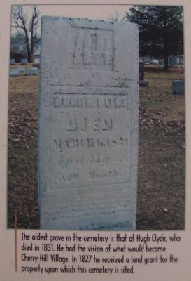
Cherry Hill Village originated in the 1830s
at the crossroads of Cherry Hill and Ridge Roads. As the economic and social center for the area, local families came here to trade at the general store, to pick up mail, to get shoes for . . . — — Map (db m99621) HM
Henry Ford built a large tree house approximately 200 yards beyond this point in a large oak. It is said Mr. Ford enjoyed its rustic natural setting, and he and his grandchildren used the tree house as a retreat. Archival records indicate Mr. . . . — — Map (db m145798) HM
Dearborn was an outpost on the western frontier
Because of expansion from Detroit and Indian disturbances to the west, in 1833 the federal government began construction of an arsenal on its military reserve land near where the Sauk Trail . . . — — Map (db m98178) HM
Parallel to the Great Meadow, the Trail Garden offered visitors a more intimate garden-walk experience. As it meandered through shrub borders and woodland, the Trail Garden was full of surprises. Large semi-circular flower beds were planted with . . . — — Map (db m96436)
This Morley Avenue neighborhood has a special history.
In the early 1800s, the U.S. government purchased this land near the Rouge River for a frontier military reserve and arsenal. When the arsenal closed in 1875, the land was sold and . . . — — Map (db m98620) HM
Then
Every year in March, when the Fords lived here, truckloads of sod from nearby fields were brought to Fair Lane along with cow manure from farms. These items were mixed in layers with grass clippings and leaves. Two months later, this . . . — — Map (db m145831) HM
East Downtown Dearborn is "the neighborhood the Rouge Plant built,"
and its fortunes have been tied to Ford Motor Company. Ford taxes generated much of the income used to build the impressive Georgian Revival-style building, which opened on . . . — — Map (db m96996) HM
Henry Ford built the City of Dearborn
His business interests drove the consolidation of the City of Fordson and the City of Dearborn in 1929. To the east were the Ford Rouge Plant and the Ford Administration Building. To the west were . . . — — Map (db m96992) HM
It was a gift for his hometown.
Henry Ford developed an 18-hole golf course at Outer Drive and Military Street that opened in 1925. With the course designed by Donald Ross and the clubhouse designed by architect Albert Kahn, Ford wanted to . . . — — Map (db m98085) HM
Once open farmland, the osage-orange tree hedge on the right still exists. It dates from the 1800's farming community that formed the boyhood environment of Henry Ford. Landscape designer Jens Jensen told the Fords he would transform the land back . . . — — Map (db m89482) HM
From State Fair to Fair Lane
Henry Ford had the miniature farmhouse, along with a miniature barn, steam engine and threshing machine, constructed for the 1924 Michigan State Fair to educate children living in an urban area about life on a . . . — — Map (db m96264) HM
The manufacturing technology developed by Henry Ford and the auto industry affected all aspects of life in early 20th century Michigan. Among the labor-saving items pioneered in the state during that period were specialized valves for watering . . . — — Map (db m89361) HM
The estate's powerhouse was the first of more than 20 hydroelectric plants built by Henry Ford. Two direct current (DC) hydroelectric generators were used to change the force of the Rouge River into electrical energy to power light bulbs, pumps, . . . — — Map (db m145852) HM
In 1916, the famed naturalist and writer John Burroughs, along with Henry Ford, laid the cornerstone of the Jens Jensen-designed grotto (an artificial recess or structure made to resemble a natural cave). Rocks were brought from the upstate New . . . — — Map (db m146137) HM
Dearborn has long been a transportation hub,
first by water and land, later by rail, air and automobile. The Rouge and Detroit rivers provided water transport to the Great Lakes. Major overland routes included the Sauk Trail (later the . . . — — Map (db m217374) HM
In 1926, a 2.5-acre rose garden was designed for this meadow, with the help of landscape architect Herbert Kellaway and rosarian Harriet Foote. Once completed, the garden contained approximately 10,000 rose plants of 400 varieties and cost more than . . . — — Map (db m98927) HM
Prior to refrigerators, the constant cool temperature of the earth surrounding a root cellar was sufficient to preserve summer produce for winter consumption. This root cellar was used to store apples, pears, onions, carrots and potatoes grown on . . . — — Map (db m145785) HM
Where you are standing now was once an open channel to the Rouge River. The Fords would pilot their boat, the Callie B, out of the boathouse to the river. The Ford grandchildren would harbor small boats here, as well. Conveniently, Mrs. . . . — — Map (db m88431) HM
Fruit orchards were planted in various locations around the estate consisting of apples, pears, cherries, and other varieties of fruit. The open lawn next to the weeping beech tree was previously an apple orchard with fruit favored by Mr. Ford. . . . — — Map (db m96261) HM
This distinctive neighborhood was born in 1919 and 1920.
In those years, Henry Ford built 156 homes for sale to his Dearborn Fordson Tractor Plant employees. The two-story, three- and four-bedroom homes were built with the most current . . . — — Map (db m120397) HM
Radio has a strong tradition in Dearborn.
In 1934, Henry Ford inspired the "Ford Sunday Evening Hour" on Detroit's WWJ - AM radio. The Detroit Symphony Orchestra appeared on the broadcast regularly and became the nation's first radio . . . — — Map (db m98481) HM
In 1915, landscape designer Jens Jensen created a picturesque rock garden masterpiece for Henry and Clara Ford. His design was engineered to work with nature and be relatively maintenance-free.
(Left Photo Caption)
In the early 1920's, . . . — — Map (db m89338) HM
Long before cars were built along the lower Rouge River
in Dearborn, the site was home to shipbuilding. Early 1700s French settlers established a small shipyard on the Rouge River at Baby Creek. The British later used the same site to build . . . — — Map (db m99189) HM
Aldo Leopold, pioneer wildlife ecologist, once said, "He who owns a veteran bur oak owns more than a tree. He owns an historical library, and a reserved seat in the theatre of evolution. To the discerning eye, his farm is labeled with the . . . — — Map (db m145829) HM
One of history's great scientists worked here.
Renowned scientist George Washington Carver and Henry Ford became friends in 1936. Both were interested in developing synthetic rubber and plastics from soybeans, peanuts and cotton. Ford built . . . — — Map (db m120318) HM
The Ford Rotunda is a lost landmark
that is still remembered fondly. Architect Albert Kahn — who designed many Ford factories and buildings — designed the building for Ford's exhibit at the 1933-34 "Century of Progress" World's . . . — — Map (db m120457) HM
Thousands of unemployed auto workers and union organizers gathered
in bitter cold on March 7, 1932 near the Fort Street Bridge, in the despair of the Great Depression. They intended to march to the Ford Rouge Plant, to present to Henry Ford . . . — — Map (db m176754) HM
There has always been a lot to stop for here.
In the 1800s, the Six Mile Inn was a rural rest stop here along the Chicago Road (today's Michigan Avenue) from Detroit. But the development nearby in the early 1900s of Ford Motor Company's . . . — — Map (db m85498) HM
Guests of the Fords came from all walks of life, and the Great Meadow that greeted them remains. Its designer, Jens Jensen, used thousands of native plantings to create this vista he labeled, "The Path of the Setting Sun-Summer." Every summer . . . — — Map (db m96937) HM
The intersection of Michigan Avenue and Schaefer Road
has been important in metropolitan Detroit's history. In its early days it was a rest stop on the road between Detroit and Chicago. Joseph Schaefer built the Six Mile House tavern at the . . . — — Map (db m121407) HM
Conditions were ripe for the rise of unionism
in the Depression-ravaged 1930s. Ford Motor Company was the last of the "Big Three" to unionize. The turning point came on May 26, 1937, when Ford security men brutally beat UAW organizers at . . . — — Map (db m120446) HM
The Chicago Road was the way to go west from Detroit.
After the Erie Canal in New York state opened in 1825, great numbers of Americans searched for their future to the west across the Great Lakes. Many of them traveled on the Chicago Road, . . . — — Map (db m96775) HM
Wyoming Avenue has a vivid industrial history.
Brick-making flourished in the 1800s as companies like Clippert, Haggerty and Mercier took advantage of the area's rich clay deposits. Automakers competing with Ford later came to this east . . . — — Map (db m120434) HM
Many fascinating stories are buried here,
of people who built Detroit on their fortunes in lumber, real
estate, cigar-making, seed, and department stores. Established
in 1867 on 250 acres of rural land, Woodmere Cemetery also
became the . . . — — Map (db m159974) HM
Stony Island, across the water and quiet now,
was a busy place in the past. In the 1870s, when Canada Southern Railroad built a railway to Canada, trains ran on tracks where Grosse Ile Parkway is now and over a bridge to Stony Island. . . . — — Map (db m152752) HM
Few islands have been so impacted by transportation.
Grosse Ile witnessed shipping on the Detroit River before the Canada Southern railway opened bridge access between the mainland and the island in 1873. Later, Michigan Central Railroad . . . — — Map (db m152702) HM
The Canada Southern Railroad built the first bridge
connecting Grosse Ile with the mainland about 1873. To link the agricultural products of the West (via Chicago) with the markets of the East Coast (via Buffalo), the railroad's most direct . . . — — Map (db m152682) HM
This building has seen a lot of travel.
The U. S. Customs House was built about 1873 by the Canada Southern Railroad along its railroad track, now Grosse Ile Parkway. Along this railway, people and freight traveled both ways across Grosse Ile . . . — — Map (db m152647) HM
There are clues that this was a railroad depot,
like the flat ground area where the train track used to be. Or the angled windows where the station master could watch trains come and go. From this Michigan Central Railroad depot, built in . . . — — Map (db m152655) HM
Great Lakes shipping and waterways had to be ready
for industry in the early 20th Century. Like roadways on land, the development of harbors and channels were critical to the growth of the economy. By 1906, the Detroit River was the busiest . . . — — Map (db m152767) HM
Grosse Ile was an isolated farming community,
accessible from the mainland only on boats (or ice in the winter) until this bridge was built about 1871. As part of a railroad that was built across Grosse Ile and the Detroit River and into . . . — — Map (db m152542) HM
The Newburgh Mill factory was built on the site of an earlier mill,
like other Ford "Village Industries." Bovee Cider Mill used to operate here along the Middle Rouge River, within the thriving village of Newburgh. In 1934, Newburgh Lake . . . — — Map (db m137131) HM
In Northville, Henry Ford tried something new.
His first "village industry" was established here in 1920, to make valves for Model-Ts and tractors, using the Rouge River for power. He hired local workers, and even selected local children . . . — — Map (db m137792) HM
It has been a Northville landmark for generations.
As far back as 1913, city residents enjoyed cold spring water from the artesian well here, and visitors traveled here to fill their bottles. On the other side of the nearby railroad tracks, . . . — — Map (db m137902) HM
Detroit was abuzz with aviation fever in the 1920s.
Eddie Stinson, a successful aviator and stunt pilot, gained financing from Detroiters to build and test-fly the prototype Stinson Detroiter airplane — the first airplane with an . . . — — Map (db m137695) HM
There were two electric streetcar lines into Northville
from Detroit, both built in 1899. One traveled on track through Farmington, along Eight Mile Road and down Griswold Street. The other came through Plymouth, up Northville Road and . . . — — Map (db m137517) HM
For many years, wool was processed here.
The Gunsolly Carding Mill operated here from 1851 to 1890, using Rouge River waterpower and machinery to process and untangle wool for spinning into yarn. Nearby villages of Plymouth and Newburgh . . . — — Map (db m137012) HM
Henry Ford wanted only women to work here
in this small factory, built in 1922 as one of his Village Industries. The women workers built electrical parts such as voltage meters, light switches and generator cutouts (a form of relay) for . . . — — Map (db m136821) HM
This comfort station was one of the early public rest stops,
and it was a prototype for roadside development. When originally constructed in 1937, this station had a full-time attendant, an information booth and concession stand. Wayne . . . — — Map (db m136913) HM
Wayne companies have gained nationwide fame here
along the railroad tracks. Prouty & Glass began to build carriages and sleighs here in 1888, and became the largest sleigh-maker in the United States. They became a prominent Wayne business, . . . — — Map (db m217355) HM
From this building many industries put people in motion.
The first was Harroun Motor Car Company, which built more than 3,000 vehicles here from 1915 to 1922. From 1924 to 1927 Gotfredson Truck made heavy duty trucks and bus chassis in this . . . — — Map (db m149713) HM
Henry Ford established this one-room schoolhouse
for children of workers at his nearby Nankin Mill village industry plant producing automotive parts. The rural school operated from 1937 to 1946 as part of Ford's Edison Institute School . . . — — Map (db m96980) HM
It was a short walk to work.
This was home to milling families who owned and operated Nankin Mills during its gristmill heyday, from 1842 to 1918. Its Greek Revival style was popular when it was built in 1834. The last farmer living here . . . — — Map (db m96981) HM
155 entries matched your criteria. Entries 101 through 155 are listed above. ⊲ Previous 100