1252 entries match your criteria. The first 100 are listed. Next 100 ⊳
National Register of Historic Places Historical Markers
This is a collection of buildings and places listed on the National Register of Historic Places (NRHP) that is administered by the U.S. Department of the Interior. This series showcases America’s notable historical and archeological resources.
Near County Road 267, 0.8 miles north of County Road 216, on the left when traveling north.
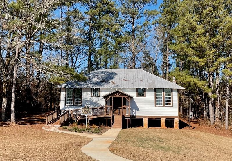
The Rosenwald School program was a collaboration
between educator Booker T. Washington and Sears
CEO Julius Rosenwald to improve educational
opportunities for African American children in
the rural South during the early 1900's. The
Rosenwald . . . — — Map (db m238815) HM
On North St. Andrews Street, on the left when traveling north.
Listed on the National Register of Historic Places by the Department of the Interior, December 16, 1977, through the efforts of the Dothan Landmarks Foundation, Incorporated.
Constructed in 1915, this three-story masonry structure remains . . . — — Map (db m83780) HM
Entered on the National Register
of Historic Places
December 31, 1974
Federal Building
U.S. Courthouse
Dothan, Alabama
James Knox Taylor Architect 1909
This property significantly contributes to the Nation's Cultural Heritage . . . — — Map (db m83781) HM
Side 1
Located in the heart of one of Montgomery's historic African-American neighborhoods. Mount Zion A.M.E. Zion Church was constructed in 1899 and heavily remodeled in 1921. It served as a significant center for religious, political, and . . . — — Map (db m86411) HM
On Cushman Street south of Illinois Street, on the right when traveling north.
By August, 1904, when a Catholic priest arrived in Fairbanks, all choice lots in the center of town were taken. Father Francis Monroe, a Jesuit missionary, selected land at the edge of town, bordering the Chena River. The first Roman Catholic . . . — — Map (db m135350) HM
On East Route 66 (U.S. 180) 0.1 miles east of North Park Drive, on the left when traveling east.
Built in 1931 by Dean Eldredge
Restored by Martin and Stacie Zanzucchi
Placed in the National Register of Historic Places
by the U.S. Department of the Interior on May 3, 1994
under the authority of Interior Secretary Bruce Babbitt
. . . — — Map (db m236440) HM
Near Village Loop Drive, 0.4 miles west of El Tovar Road, on the right when traveling west.
Originally this building stood at Red Horse, 25 miles south of the Grand Canyon, where it was possibly used as one of the stage stops between the Grand Canyon and Flagstaff. In 1902, Ralph Cameron had it moved to its present site, where, with the . . . — — Map (db m236357) HM
On El Tovar Road, 0.1 miles north of Village Loop Drive, on the right when traveling west.
For Mary Colter, [Hopi Housel was an opportunity to re-create the distinctive dwelling of an ancient culture and to acquaint the public with the richness and beauty of Native American art. – Virginia Grattan, Mary Colter: . . . — — Map (db m236334) HM
On Historic Route 66 at South 2nd Street, on the right when traveling east on Historic Route 66.
Built in 1892 by Samuel E. Patton for Cormick E. Boyce known as “the man who built Williams.” With its own water supply, it was the only surviving building of the 1895 fire. First-class hotel designed to appeal to travelers to the Grand Canyon. . . . — — Map (db m236382) HM
On Historic Route 66 east of North 3rd Street, on the left when traveling east.
Williams was a touhh frontier town
filled with cowboys, loggers, and
railroad workers. Gambling and
prostitution were legal in one
area of town until 1907. It was also
hone to civic-minded citizens who
forged a community and created
this . . . — — Map (db m236370) HM
On Historic Route 66 east of North 3rd Street, on the left when traveling east.
In 1898 the forested lands around
Williams were set aside as a forest
reserve that supplied timber for
the Saginaw-Manistee lumber mill
and box factory, which operated
from 1893 to 1942. Built by the
Rounseville brothers about 1915,
this . . . — — Map (db m236374) HM
Near East Van Buren (U.S. 62) just west of County Road 205, on the right when traveling west.
When Judas, betrayer of Jesus, repented and returned the thirty pieces of silver, the chief priests refused them, then “took counsel and bought with them the Potter’s Field to bury strangers in”. Matthew 27:3-10 KJB thus began the tradition. Names . . . — — Map (db m229498) HM
On Caddo Street at North 16th Street, on the right when traveling west on Caddo Street.
PHS
Dedicated
This landmark is erected on the original site of Peake School built on land donated by Mr. Ed Peake in 1928, and is dedicated to the faculties and staffs who encouraged and prepared us to compete on an equal level with the best . . . — — Map (db m234859) HM
On North 1st Street at West Main Street (Arkansas Route 53), on the left when traveling north on North 1st Street.
In the Hotel Hall which formerly stood on the site of this building was organized on January 21st 1892 the Concatenated Order of the Hoo-Hoo a society composed of lumbermen and those in allied industries and having for its object the promotion . . . — — Map (db m234904) HM
On Main Street east of South 3rd Street, on the right when traveling east.
[Northwest face]
1899
Furled but not forgotten
1861 C.S.A. 1865
Erected by the Mary Lee Chapter
United Daughters of the Confederacy
[Southwest face]
Battles
Oak Hill – Aug. 10, 1861.
Elk Horn – March 6 to 8, 1862. . . . — — Map (db m236850) WM
On West Main Street at North Central Avenue, on the right when traveling west on West Main Street. Reported missing.
Originally constructed in 1875 as an opera house,
eight years later in 1883 it was converted to a
mercantile store. In 1939, then known as the
Brewer Store, it was purchased by Commonwealth
Theaters, remodeled in the Art Deco style and, . . . — — Map (db m221126) HM
On South Jefferson Street at West Bradley Street, on the left when traveling south on South Jefferson Street.
[southwest panel] In memory of our Confederate heroes 1861—1865 [southeast panel] Lincoln County remembers the faithfulness of her sons and commends their example to future generations [northeast panel] Erected by Capt. J. . . . — — Map (db m238099) WM
On West Bradley Street just east of South Jefferson Street, on the right when traveling east.
This property has been placed on the National Register of Historic Places by the United States Department of the Interior Owner Elizabeth Pickens — — Map (db m238097) HM
On West Bradley Street east of South Jefferson Street, on the right when traveling east.
This property has been placed on the National Register of Historic Places by the United States Department of the Interior Owner: Gene Yarbrough Family — — Map (db m238096) HM
On Front Street Northwest at Park Street when traveling east on Front Street Northwest.
The Lonoke Depot has been placed on the National Register of Historic Places by the United States Department of the Interior. Built in 1912, it was an important stop on Arkansas' oldest railroad, the Memphis to Little Rock line. The depot is a . . . — — Map (db m211575) HM
On Center Street just north of West 15th Street, on the right when traveling south.
This property has been placed on the National Register of Historic Places by the United States Department of the Interior Arkansas Historic Preservation Program — — Map (db m229495) HM
On North 13th Street north of Garrison Avenue, on the left when traveling north.
The first Catholic church in Fort Smith was a log structure at North 3rd
and D Street. The Church of St. Patrick was dedicated March 5, 1848.
Bishop Andrew Byrne had purchased a square mile of land on the
outskirts of Fort Smith in 1847, upon . . . — — Map (db m236804) HM
On North Forrest Street at East Garland Avenue, on the left when traveling north on North Forrest Street.
Home of W. W. Campbell and Victoria Mann
Campbell. W. W. Campbell was a bank, civic,
and agricultural leader in Eastern Arkansas.
influence extended nationally as reported in
the November, 1947, issue of Readers Digest
and the November, . . . — — Map (db m243314) HM
On East Douglas Street (U.S. 62), on the right when traveling west.
(Upper Plaque):This property has been placed on the National Register of Historic Places by the United States Department of the Interior (Lower Plaque): Hindman Hall Museum At bequest by Biscoe Hindman, son of General Thomas C. Hindman . . . — — Map (db m35253) HM
Near Mount Curve Avenue East at Lake Avenue, on the left when traveling west.
marker at amphitheater:
Built by
United States
Works Progress
Administration -
1938.
marker at basketball courts:
Improved by
Works Progress
Administration -
1937. — — Map (db m243384) HM
Near Alameda Street at Los Angeles Street, on the left when traveling north.
The largest and most significant of the fourteen substations in the city, this brick power-transforming plant was built by the Los Angeles Railway Company to convert electricity from alternating current (AC) to direct current (DC) so as to provide . . . — — Map (db m122529) HM
On Hermosa Avenue at Colorado Boulevard, on the left when traveling north on Hermosa Avenue.
Eagle Rock Women's Twentieth Century Clubhouse,
Craftsman style,
built 1915. Declared 1991,
Historic-Cultural Monument No. 537,
City of Los Angeles,
Cultural Heritage Commission,
Cultural Affairs Department. — — Map (db m232560) HM
On Santa Monica Boulevard at Madison Avenue, on the right when traveling west on Santa Monica Boulevard.
The Patron Saint of Libraries
Born in Scotland, self-made steel magnate Andrew
Carnegie (1835-1919) built his fortune in America.
A major philanthropist, Carnegie was dedicated to
expanding educational opportunities for . . . — — Map (db m234299) HM
On Hollywood Boulevard at Western Avenue, on the right when traveling east on Hollywood Boulevard.
Art Deco style.
S. Charles Lee, architect.
Built 1929. Declared 1988,
Historic-Cultural
Monument No. 336,
Cultural Heritage Commission,
City of Los Angeles. — — Map (db m231780) HM
On Western Avenue just south of Hollywood Boulevard, on the right when traveling south.
The Bricker Building
has been placed on the
National Register
of Historic Places
by the United States
Department of the Interior,
January 7, 2011.
Excellent example of an early
mixed-use building in Hollywood.
Italian Renaissance Revival . . . — — Map (db m231781) HM
On Hollywood Boulevard at Vine Street, on the left when traveling east on Hollywood Boulevard.
Gothic Revival and Art Deco styles.
Aleck Curlett, architect.
Built 1929, 1931. Declared 2015,
Historic-Cultural
Monument No. 1088,
Cultural Heritage Commission,
City of Los Angeles. — — Map (db m231841) HM
On Sunset Boulevard, 0.2 miles east of Highland Avenue, on the left when traveling east.
Crossroads of the World, 1936.
Robert V. Derrah, architect.
A blend of moderne & old world architecture.
Declared Historic-Cultural Monument No. 134 by the Cultural Heritage Commission, Cultural Affairs Department, City of Los Angeles. . . . — — Map (db m162878) HM
On Grace Avenue at Franklin Avenue, on the left when traveling south on Grace Avenue.
Circa 1927.
Built by Cecil B. DeMille, Filmmaker.
Los Angeles Historic-Cultural Monument #773.
National Register of Historic Places. — — Map (db m231738) HM
On Hollywood Boulevard west of Highland Avenue, on the left when traveling west.
Greek Revival style.
Architect - John C. Austin.
Built 1921. Declared 1984,
Historic-Cultural Monument No. 277,
City of Los Angeles,
Cultural Heritage Commission,
Cultural Affairs Department. — — Map (db m231797) HM
On Franklin Avenue east of Argyle Avenue, on the right when traveling east.
Sophisticated living
for film luminaries
during the "golden
age" of Hollywood.
Placed on the National
Register of Historic
Places by the U.S.
Department of Interior. — — Map (db m231561) HM
On Melrose Avenue at June Street, on the right when traveling west on Melrose Avenue.
John C. Fremont Library,
completed May, 1927,
M.L. Barker, architect.
Significant Cultural Landmark,
Windsor Square-Hancock Park Historical Society. — — Map (db m233956) HM
On Whitley Avenue north of Hollywood Boulevard, on the right when traveling north.
Dutch Colonial Revival style.
Architects - Dennis & Farwell.
Built 1919. Declared 1988,
Historic-Cultural Monument No. 448,
City of Los Angeles,
Cultural Heritage Commission,
Cultural Affairs Department. — — Map (db m232573) HM
Stahl House - Case Study House No. 22,
International style.
Architect - Pierre Koenig, F.A.I.A.
Built 1958.
Declared 1999,
Historic-Cultural Monument No. 670,
City of Los Angeles,
Cultural Heritage Commission,
Cultural Affairs Department. — — Map (db m183283) HM
On Exposition Boulevard, 0.3 miles east of Vermont Avenue, on the right when traveling east.
From Sin to Science, A Park For The People
For decades into the 20th century, Los Angeles not only fed the world’s imagination with films and television — it fed the world’s bellies, too.
Los Angeles County prided itself on . . . — — Map (db m216967) HM
This property has been placed on the National Register of Historic Places by the United States Department of the Interior.
Builder’s plaque:
The Baldwin Locomotive Works, Philadelphia, U.S.A. May, 1927.
60004 — — Map (db m239924) HM
On Dell Avenue just north of Court A, on the left when traveling north.
Inspired by the canals of Venice, Italy. Built 1906. Declared 1983, Historic Cultural Monument No. 270, Cultural Heritage Commission, City of Los Angeles, Cultural Affairs Department. — — Map (db m178246) HM
On Hillcrest Avenue east of Oak Knoll Avenue, on the left when traveling east.
Charles & Henry Greene, architects,
designed in 1911,
has been placed on the National Register of Historic Places by the United States Department of the Interior. — — Map (db m231910) HM
This property is listed in the National Register of Historic Places by the United States Department of the Interior.
John K. Van De Kamp Bridge, formerly known as La Loma Bridge is an open-spandrel-arch reinforced concrete bridge . . . — — Map (db m235281) HM
On Baldwin Avenue at Laurel Avenue, on the right when traveling north on Baldwin Avenue.
This property has been placed on the National Register of Historic Places by the United States Department of the Interior.
Sierra Madre Historical Landmark,
Church of the Ascension - Episcopal,
1888,
Ernest A. Coxhead - architect. . . . — — Map (db m241932) HM
On Fair Oaks Avenue at Oaklawn Avenue, on the right when traveling south on Fair Oaks Avenue.
A singular example of functional public art by architects Charles and Henry Greene, this 1906 span was one of the country's first reinforced concrete bridges.
Recognized by Hampton Hotels Save-A-Landmark program as a site worth seeing. . . . — — Map (db m206059) HM
On Kings Road, 0.2 miles north of Melrose Avenue, on the left when traveling north.
California Office of Historic Preservation acquisition of this property, which is listed in the National Register of Historic Places,
has been funded with the assistance of a matching
grant from the Department of the Interior, . . . — — Map (db m183272) HM
On Truslow Avenue at Malden Avenue, on the right when traveling west on Truslow Avenue.
This property - Elephant Packing House - has been placed on the National Register of Historic Places
by the United States Department of the Interior. — — Map (db m241881) HM
On Santa Fe Avenue just east of Harbor Boulevard, on the right when traveling east.
Union Pacific Depot,
built 1922,
has been placed on the
National Register
of Historic Places
by the United States
Department of the Interior.
City of Fullerton Local Landmark No. 7, Union Pacific Depot, Built 1923.
Plaque placed by . . . — — Map (db m217860) HM
On Chapman Avenue east of Center Street, on the right when traveling east.
Lewis Ainsworth (1829 - 1914) and his wife Persis (1837 - 1933)
chose the city of Orange as their home in 1901 after making
their fortunes panning gold in California and farming in
Kansas.
The Ainsworths raised three sons, Lewis, . . . — — Map (db m241276) HM
On Glassell Street at Almond Avenue, on the right when traveling south on Glassell Street.
Established in 1886, the plaza was for many years the local and commercial hub of Orange. The plaza historic district attained significance throughout the state as a historic landmark in 1981 and was placed on the National Register of Historic . . . — — Map (db m189682) HM
On Center Street south of Chapman Avenue, on the left when traveling south.
Women’s Club of Orange, established 1915.
Old Towne Preservation Association.
This property is within the Old Towne Orange Historic District, placed on the National Register of Historic Places by the United States Department of the . . . — — Map (db m241287) HM
Near Los Rios Street north of Verdugo Crossing, on the left when traveling north.
This area was
inhabited by the
Acjachemen Nation
Native Americans
before nearby Mission
San Juan Capistrano
was established.
Los Rios Street is the
oldest continually
occupied residential
neighborhood
in California.
There are 31 . . . — — Map (db m169565) HM
On Park Avenue at Victory Road, on the right when traveling south on Park Avenue.
History of the Air Base from 1942 to 1949
In March 1942, the Navy Bureau of Yards and Docks contracted with Holmes & Narver Consulting Engineers of Los Angeles to design and engineer an LTA base that would accommodate the design for . . . — — Map (db m190132) HM
On 6th Street at Buena Vista Avenue, on the left when traveling east on 6th Street.
Adapted and reused as City Hall & Civic Center, 1962-2004. Has been placed on the National Register of Historic Places by the United States Department of the Interior, August 3, 2005. — — Map (db m233632) HM
This station was already in operation when U.S. Route 66 was established in 1926 and was a welcome place to stop between San Bernardino and Los Angeles on what became known as America's Mother's Road.
This property is listed in the National . . . — — Map (db m230434) HM
Near Torrey Pines Scenic Drive, 0.5 miles west of Torrey Pines Road.
To honor the spirit,
ingenuity, and enthusiasm
of the pioneers who flew
gliders in the 1930’s
at Torrey Pines, and to the future pilots who will share this
gliderport and continue
this tradition through all forms of
motorless flight. . . . — — Map (db m169295) HM
On East Main Street (Delaware Route 273) at The Green, on the right when traveling west on East Main Street.
[Left plaque]
Alumni Hall
has been placed on the
National Register
of
Historic Places
[Right plaque]
Alumni
Hall
Erected before 1810 — — Map (db m152669) HM
On East Jordan Street at North Davis Street (Florida Route 291), on the right when traveling east on East Jordan Street.
The Historic Crystal Icehouse is a slice of early twentieth century life,
frozen in time. Built in 1932, the icehouse has been an Eastside
Neighborhood icon for many years. It was an integral part of
neighborhood life during the years before . . . — — Map (db m177056) HM
On Central Avenue SE at 5th Street SE, on the right when traveling north on Central Avenue SE.
First Methodist Church
of Jasper
Built 1878
Placed on National Register of
Historical Places September 29, 1978
Presented by Hamilton County Historical Society — — Map (db m123253) HM
1252 entries matched your criteria. The first 100 are listed above. Next 100 ⊳