Panel 1
How Did Braxton County Get Its Name?
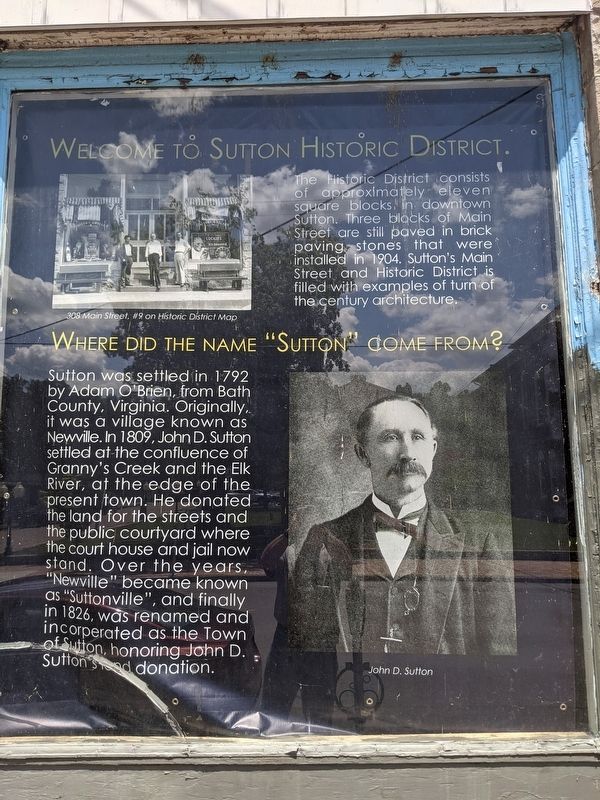
Ten years after Sutton was incorporated, Braxton County was formed in 1836. The new county was named after Carter Braxton, a signer of the Declaration of Independence. The Town of Sutton . . . — — Map (db m173346) HM
On Main Street west of 3rd Street, on the right when traveling west.
Honoring Revolutionary War Soldiers and Patriots buried in Braxton County.
Andrew Skidmore, 1750-1827 • Charles Francis Boggs Jr., 1754-1837 • Jacob Fisher 1763-1846 • Peter Shields, 1755-1832 • John Dobbins 1747-1833 • Patrick Murphy, . . . — — Map (db m179591) WM
On Main Street at Camden Avenue (West Virginia Highway 4), on the right when traveling east on Main Street. Reported permanently removed.
In 1861, Col. Erastus B. Tyler’s 7th Ohio Infantry constructed earthworks near Suttonville to protect the suspension bridge across the Elk River. Later in the year, Capt. Weston Rowand’s Co. K, 1st Virginia Cavalry (US), about a hundred men, . . . — — Map (db m58728) HM
On Main Street at 3rd Street, on the right when traveling west on Main Street.
(Preface): On April 20, 1863, Confederate Gens. William E. “Grumble” Jones and John D. Imboden began a raid from Virginia through present-day West Virginia against the Baltimore and Ohio Railroad. Taking separate routes, . . . — — Map (db m58729) HM
On Main Street west of 3rd Street, on the right when traveling west.
Boggs, Clarence H. • Brown, Solomon • Buckner, Thomas • Carr, Benjamin H. • Clayton, Harry • Clowser, David • Conley, John P. • Craft, John E. • Criss, Guy Harley • Cutlip, William I, • Dobbins, Thomas • Dulin, Edwin L. • Exline, Oscar • Fisher, . . . — — Map (db m179590) WM
On Old Turnpike Road (Local Route 19/40) at Centralia Road (Local Route 17), on the right when traveling north on Old Turnpike Road.
The geographic center of the irregular-shaped state of West Virginia is near this point, according to accepted methods of locating centers of geographic areas. It was also West Virginia's center of population in 1860. — — Map (db m173331) HM
On West Virginia Route 2 at Park Avenue, on the right when traveling south on State Route 2.
Near here stood Beech Bottom Fort, which was with Fort Pitt and Fort Henry in the group of posts guarding the western borders during the Revolution and its attendant Indian wars. Troops from Fort Pitt helped garrison this important fort. — — Map (db m54915) HM
On River Road (West Virginia Route 2) 0.2 miles north of Caroline Avenue, on the left when traveling north.
On land near here was state's first military airfield, home to the West Virginia Flying Corps. Founded in April 1917 by Louis Bennett Jr. and backed by state and private funds, the corps was modeled after the French Lafayette Escadrille with the . . . — — Map (db m176858) HM
On Main Street (West Virginia Route 67), on the right when traveling west. Reported missing.
Here lived the leading influence in America's largest indigenous religious movement, Christian Church (Disciples of Christ), and founder of Bethany College. Built in four periods: the John Brown Mansion, completed in 1793; Buffalo Seminary, in 1819; . . . — — Map (db m20826) HM
Born in Prince Edward Island, Canada, September 4, 1849
Died December 15, 1920
Fourth President of Bethany College
For thirty-nine years Chief Executive of the
Foreign Christian Missionary Society
Every missionary sent to . . . — — Map (db m20836) HM
On Main Street (West Virginia Route 67) 0.2 miles east of West Virginia Route 88, on the right when traveling east.
Bethany
Here Scots-Irish Alexander Campbell founded a religious movement which he called the Disciples of Christ. In this place Amos Dolbear perfected parts of the telephone, and longtime Speaker of the House "Champ" Clark, Supreme Court . . . — — Map (db m79899) HM
On Main Street (Route 67) at Fairway Street, on the right when traveling east on Main Street.
Bethany
Bethany College, established here in 1840, oldest school of college rank in State. The home and the study of Alexander Campbell, founder, are here. Prof. A. E. Dolbear here perfected parts of the telephone, which Bell used.
. . . — — Map (db m79900) HM
On Main Street at Church Street, on the right when traveling east on Main Street.
Bethany Church of Christ, the oldest church building in Bethany, was built in 1852 according to plans drawn by Alexander Campbell, founder of Bethany College and leader in the Disciples Movement. Its foundation is built of stone from the original . . . — — Map (db m20830) HM
On Main Street (West Virginia Route 67), on the right when traveling east. Reported missing.
Here are buried the Campbell family; the first missionaries, other prominent leaders in the Disciples Movement, presidents and distinguished teachers of Bethany College. The seven foot hand hewed stonewall is a unique feature of Cemetery. — — Map (db m20963) HM
On Main Street (West Virginia Route 67), on the right when traveling east.
In this house, 8 Bethany College Students - William Cunningham, John Johnson, Alexander Earle, Richard Alfred, Eugene Tarr, Henry Bell, John Hunt and Jacob Lowe - Met in 1858 and founded Delta Tau Delta. This social fraternity soon spread across the . . . — — Map (db m20849) HM
Near College Street at Main Street (West Virginia Route 67).
A major grant from the Renner Foundation, which was matched by alumni gifts, made possible, in 1970, the complete remodeling of Bethany House built in 1948. Henry Clay and James A. Garfield were among the notable guest at the first Bethany House . . . — — Map (db m79901) HM
Born in County Down, Ireland, Feb. 1, 1763, and died at the residence of his son Alexander, Jan. 4, 1851, aged 91 years, 11 mthns, five days. Many years a minister of the Secession Presbyterian Church in Ireland and Scotland. In the United States . . . — — Map (db m20835) HM
Near Eldersville Road (West Virginia Route 27) at St. John's Road, on the right when traveling west.
Founded in 1793 by Joseph Doddridge. It is the first Episcopal Church west of the Alleghenies and the oldest continuous worshipping congregation within this religious body in West Virginia. The first church, made of logs, was burned by Indians. . . . — — Map (db m79897) HM
On Main Street (West Virginia Route 2) at Raymond Street, on the right when traveling north on Main Street.
This monument was dedicated by American Legion Post 45 on Memorial Day May 25, 1998 to honor our heroes who served
in World War I - World War II - Korea - Vietnam
Granada - Lebanon - Panama and the Persian Gulf — — Map (db m223836) WM
On Main Street (West Virginia Route 2), on the right when traveling north.
John Decker built a fort of logs and stone on a site just north of State St. near Ohio River, 1774. Leaden bullets and arrowheads found here on the river bank signify Native American attack on the fort from Mingo Island. — — Map (db m21605) HM
On Main Street (West Virginia Route 2) at Raymond Street, on the right when traveling north on Main Street.
This flag pole is dedicated to the memory of
Joseph "Joey" Perito
who died for our freedom during the Vietnam War in the U.S. Army — — Map (db m223725) WM
On Main Street (West Virginia Route 2) at Raymond Street, on the right when traveling north on Main Street.
Dedicated to the honor and sacrifice of our men and women of Cross Creek District who honorably served our country in all wars
☆ ☆ ☆ ☆ ☆
This memorial is erected in grateful remembrance to those the living . . . — — Map (db m225649) WM
On Main Street (West Virginia Route 2) at Raymond Street, on the right when traveling north on Main Street.
WACs Army •
WAVES Navy •
WAF Air Corps •
AWRS Marines •
SPARS Coast Guard •
WASP Air Service Pilots •
Nurses Corps •
Red Cross Salvation Army •
Gold Star Mothers •
U S O •
Women Defense Workers •
Women Air Raid Wardens — — Map (db m223708) WM
On Archer Hill Road at West Virginia Route 2, on the right when traveling west on Archer Hill Road.
Village of Power. Built to house employees of the
Windsor Power Plant, the village
of Power consisted of 100 homes
along tree-lined streets, a post
office, and a company-owned store.
There also was a fulltime doctor.
Residents gathered . . . — — Map (db m164737) HM
On Military Drive, 0.1 miles south of Marshaling Yard Drive, on the right when traveling south.
In memory of
Joseph Robinson
who made the Supreme Sacrifice
and
the following members of the
Weirton Heights Volunteer Fire Dept.
who served their country in World War II
Ray Poland • John Ritchie • Obie Phebus • Robert De . . . — — Map (db m155999) WM
On Military Drive just south of Marshaling Yard Drive, on the right when traveling south.
In memory of those who perished September 11, 2001 during the Attack on America
Steel Beams from the World Trade Center New York City
Weirton Steel Corporation presented these World Trade Center steel beams to . . . — — Map (db m160900) WM
Near Military Drive, 0.1 miles south of Marshaling Yard Drive, on the right when traveling south.
In memory of
William "Bill" Courtney (1950 - 2010)
Husband ~ Father ~ Brother ~ Friend
Patriot
27 years military service
Forever in our hearts
U.S. Navy
U.S. Air Force — — Map (db m155996) WM
On Charles Street at 6th Street, on the left when traveling north on Charles Street.
Constructed by Alexander Wells at
65 Washington St., Buffaloe, Virginia
(present day Third St.,
Wellsburg, West Virginia)
The Wells Log House was, and is, in the
“National Register of Historic Places”
District of . . . — — Map (db m21634) HM
Near Main Street at 7th Street, on the right when traveling north.
(Brooke County, Virginia) was built here in 1799 by Samuel Herdman, who lived to see it torn down and re-built in 1849 as the present Brooke County West Virginia Courthouse — — Map (db m189409) HM
On Bethany Pike (West Virginia Route 67) 0.1 miles north of McCord Hill Road (County Route 67/2), on the right when traveling north.
First highway tunnels constructed west of Alleghenies. They were built in 1831 by Richard Waugh at personal expense to ease transportation to his flour mills. The tunnels, a mile apart, were removed by the State in 1957. — — Map (db m21614) HM
On Charles Street, on the left when traveling north.
Dedicated to the men and women from Brooke County who have honorably served in the armed forces of our country in time of war and peace — — Map (db m21616) HM
On Commerce Street (West Virginia Route 2) north of 12th Street, on the right when traveling south.
Born in Wellsburg. January 8. 1819, Tarr opposed Virginia secession in 1861. A staunch Unionist. he was a delegate to the first and second Wheeling conventions, raised Union Troops, and was treasurer for the Restored Government of Virginia. He . . . — — Map (db m189408) HM
On West Virginia Route 27 at Northview Road, on the left when traveling east on State Route 27.
Constructed by John Fowler, 1848-51 with bricks fired on the property. First known as Fowler's Inn, the house provided food and lodging for drovers herding livestock over the Wellsburg-Washington Turnpike to eastern markets. Other services provided . . . — — Map (db m42167) HM
On West Virginia Route 2, 0.1 miles north of Cross Creek Road, on the right when traveling north.
George Washington began a journey on October 5, 1770 to the Ohio Country to see lands he had fought to win and now hoped to own. After a trip, on November 3, up the Kanawha River, the party headed back up the Ohio River. On November 17, they reached . . . — — Map (db m33913) HM
On Washington Pike (West Virginia Route 27) at Bradys Ridge Road, on the right when traveling east on Washington Pike.
Watering trough marks location of first Grimes Golden Apple tree, discovered by owner of land, Thomas Grimes, in 1802. Memorial Trough sponsored by the Franklin Country Women's Club in 1922. — — Map (db m70931) HM
On Commerce Street (West Virginia Route 2) at 3rd Street, on the right when traveling north on Commerce Street.
The first glass house in Western Virginia was built at Charlestown, now Wellsburg, in 1813, by Isaac Taylor Duvall and Company. It was located on the southeast corner of Fifth and Yankee Streets. Cobalt blue, green and clear flint glass wares were . . . — — Map (db m39642) HM
On West Virginia Route 2 at Commercial Street Exd, on the right when traveling north on State Route 2.
Born in Wellsburg in 1824, Duval worked as a scout in the western US and joined the 1849 Gold Rush before returning to Brooke County. He served in the Union Army during the Civil War. rising to the rank of major general. Postwar, Duval served terms . . . — — Map (db m167222) HM
On 6th Street at Main Street, on the right when traveling west on 6th Street.
Built by John Henderson prior to 1798 in Federal style, the building was leased by William Miller and operated as a tavern for 50 years. Since 1974 building has housed the Brooke County Museum. — — Map (db m21628) HM
On Main Street at 6th Street, on the right when traveling south on Main Street.
Sergeant on the Lewis and Clark
Expedition, he published the first
account of that exploration in 1807
Veteran of the War of 1812, he
fought in the Battle of Lundy's Lane
and at Fort Erie
Citizen of Wellsburg for more than . . . — — Map (db m21629) HM
On Commerce Street (West Virginia Route 2) north of 22nd Street, on the right when traveling south.
Born 12 June 1771, Gass served as carpenter for Lewis and Clark. The expedition explored and studied the land, waterways, animal life, natural features and resources of the West. Gass's journal of trip was published in 1807. Soldier in the War of . . . — — Map (db m39731) HM
On Pleasant Avenue at 23 rd Street, on the right when traveling north on Pleasant Avenue.
The grave of Patrick M. Gass, a sergeant on the Lewis and Clark Expedition and a soldier of the War of 1812 is located in this cemetery. His wife Maria is buried beside him. — — Map (db m54977) HM
On Main Street at 6th Street, on the right when traveling south on Main Street.
The Corps of Discovery, under the command of Meriwether Lewis and William Clark, was the first official expedition through the interior of the North American Continent sponsored by the United States.
Captain Meriwether Lewis passed Charles . . . — — Map (db m21639) HM
On Charles Street at 11th Street, on the left when traveling north on Charles Street.
Methodism in Wellsburg dates back to 1787 with the establishment of the “Ohio Circuit.” Early services were held in “The Academy” on High Street. Bishop Asbury preached at the courthouse on September 6, 1803.
On April . . . — — Map (db m21635) HM
On Bethany Pike (West Virginia Route 67) 0.1 miles north of McCord Hill Road, on the right when traveling south.
Four flour mills were constructed near Wellsburg in the early 1800s. The first of these mills was built by John Moore in 1800. Moore's son-in-law, Richard Waugh, built the old stone mill in 1824, and the upper mill in 1835. A. M. Buchanan built the . . . — — Map (db m79898) HM
On Commerce Street (West Virginia Route 2) south of 3rd Street, on the right when traveling north.
Established in 1791. Brooke Academy, started, 1778, incorporated in 1799. Here lived Joseph Doddridge, the author of "Frontier Notes," and Patrick Gass, member of the Lewis and Clark Expedition and author of its "Journal." — — Map (db m39699) HM
On Main Street at 6th Street, on the right when traveling south on Main Street.
In the 1790's, flatboats left here with their cargoes for southern markets. To accommodate and store products, warehouses and wharfs were built along our river banks. This wharf, which was established in the 1800's, extended twenty feet out in the . . . — — Map (db m21637) HM
On Main Street at 6th Street, on the right when traveling south on Main Street.
This giant Sycamore tree stands at the top of the Wellsburg Wharf it was planted in the early years of the 19th century by Dr. Albert Wheeler who practiced medicine in Wellsburg until his death in 1864.
It was under this tree that militiamen . . . — — Map (db m21641) HM
On Main Street at Water Street, on the right when traveling west on Main Street.
The Village of Barboursville honors all her military sons and daughters and all other veterans everywhere, who have faithfully served the United States of America in times of peace and in times of war. We are extremely proud of all our veterans. . . . — — Map (db m228334) WM
Established, 1813. County seat moved here from Guyandotte and remained until taken to Huntington in 1887. Before the Guyandotte courthouse was chosen,court met at the home of William Merritt, 1809-1810, on Mud River near here. — — Map (db m227463) HM
On Main Street west of Central Avenue, on the right when traveling west.
Confederate Gen. Henry A. Wise’s army occupied the Lower Kanawha Valley in June 1861. Union Gen. George B. McClellan assigned the task of driving them out to Gen. Jacob D. Cox, who massed his troops in Gallipolis, Ohio. Cox planned to cross the Ohio . . . — — Map (db m73692) HM
On Water Street at Midland Trail (U.S. 60), on the left when traveling north on Water Street.
Site of early Civil War battle fought July 13, 1861. Border Rangers and local citizens met on “Fortification Hill” to repel an advance by five companies of the 2nd Kentucky Inf. After firing several volleys, Union troops made a bayonet charge up . . . — — Map (db m239111) HM
On Brady Street east of Central Avenue, on the left when traveling east.
Frontier Army Scout and Indian fighter Supplied buffalo meat to Kansas Pacific Railroad.
In 1883 he presented a Wild West Show.
A Sioux Warrior named Iron Tail was in the Cody Wild West Show-whose face is on the buffalo nickle. . . . — — Map (db m228318) HM
Named for General Walton W. Walker
First new tank built after World War II
Existence announced in March 1951. Weaponry included 76mm gun. 50 & 30 caliber machine guns. Carried crew of four with a combat weight of 26 tons.
Powered by a . . . — — Map (db m228326) HM
This park has been named Nancy Cartmill Gardens in honor of Nancy Hunter Cartmill. Mrs. Cartmill was the first woman to be elected Mayor of Barboursville and served from 1993 to 2001.
Major Cartmill was instrumental in attracting business . . . — — Map (db m125915) HM
This old toll house, built in 1837, stood below town of Barboursville on Guyan River bank; tolls collected on James River - Kanawha Turnpike from those using the ferry. Restored in 1950 by the D.A.R., Barboursville — — Map (db m64095) HM
Bridge named for Hershel "Woody" Williams, who as a corporal in 3rd Marine Div. during World War II won Congressional Medal of Honor for heroism against the Japanese at Iwo Jima, 23 February 1945. — — Map (db m73686) WM
On Main Street at Water Street, on the right when traveling north on Main Street.
George W. Pinson • Edmund Baumgardner • F. Bricky Baumgardner • Joe Lee Anderson • Ray O. Anderson • Bruce B. Hash • W. Paul Adkins • Fred Wroten • Linford Wroten • James "Jimmy" Bailey • Orville Soward • W. "Buddy" Hicks • W. "Bill" Hambleton • . . . — — Map (db m232832) WM
On Guyan St north of 5th Avenue, on the right when traveling north.
Born January 1809 in Massachusetts, he was a lawyer who came to Cabell County shortly before the Civil War. A Unionist, he fled when A. G. Jenkins called for his arrest. From 1861 to 1863, he was a delegate to the constitutional convention for the . . . — — Map (db m178192) HM
On Guyan Street north of 5th Avenue, on the right when traveling north.
First located in Gallipolis, Ohio,
the house, owned by James Gallaher.
was floated down the Ohio River to
Guyandotte in 1810. Obtained by the
Carroll family, it was used as an
inn and site for Catholic Mass.
On November l1, 1861, Mary . . . — — Map (db m178157) HM
On 11th Street at Veterans Memorial Boulevard (U.S. 60), on the left when traveling south on 11th Street.
Born and raised in Huntington, WV, Mary hopped a train and left town at age 13 to become a singer and dancer. She spent the 1920’s and 30’s performing in medicine and minstrel shows. During the 1940’s, Mary had diamonds removed from a bracelet and . . . — — Map (db m73736) HM
On 11th Street south of Veterans Memorial Boulevard (U.S. 60), on the left when traveling south.
B&O Railroad Depot. Passenger station completed 1887, freighthouses 1890 with additions 1898, 1911 & 1916. B&O, oldest U.S. line, acquired in 1901. Superior location in business district gave B&O edge over C&O in city.
Heritage Village. . . . — — Map (db m213392) HM
Near Guyan Street north of 5th Avenue, on the left when traveling south.
When the Civil War began, few of Guyandotte’s residents were slaveholders, but many townspeople resented any infringement on their right as Virginians to own slaves. Guyandotte was reportedly the only town on the Ohio River that voted in favor of . . . — — Map (db m144784) HM
Near Guyan Street north of 5th Avenue, on the left when traveling south.
After capturing Guyandotte on November 10, 1861, and rounding up civilian Unionists and Federal recruits, Confederate forces under Col. John Clarkson and Col. Albert G. Jenkins began the next day to leave the town with their prisoners. At the . . . — — Map (db m238229) HM
On 8th Street north of 5th Avenue (U.S. 60), on the left when traveling north.
This Tablet Erected to Commemorate the
150th Anniversary of the Founding of Cabell County
Formed from Kanawha County in 1809. Included Wayne, Mingo and parts of Logan, Boone, Putnam and Lincoln. Named in honor of Governor William H. Cabell of . . . — — Map (db m126799) HM
On Hal Greer Blvd at 9th Avenue on Hal Greer Blvd.
Historian, author, educator. Founder of the Assoc. for the Study of Negro Life & History, 1915. Began Journal of Negro History, 1916. In 1926 began Negro History Week, later Black History Month. A graduate and later principal, Douglass H.S., . . . — — Map (db m213391) HM
On West 14th Street at Memorial Boulevard on West 14th Street.
The 1308, built in 1949, was one of the last working steam locomotives built by Baldwin Locomotive Works for a Class 1 railroad in the USA. It primarily hauled coal from Logan Co. Retired from C&O Railway service in 1956. Moved in September 1962 to . . . — — Map (db m60349) HM
Near 4th Avenue just east of 7th Street, on the right when traveling east.
The bell was cast by Meneely Bell Company, Troy, New York and shipped to Cabell County, WV, on May 18, 1901, weighing 1,506 pounds without fittings. Due to deterioration of the cupola which housed the bell, it was removed from the top of the . . . — — Map (db m208507) HM
On 11th Street near Veterans Memorial Boulevard (U.S. 60), on the left when traveling south.
Built by American Locomotive Company in 1924, the #10 was used to haul mine waste from Rich Run Mine in Widen, WV. Retired from Elk River Coal and Lumber in 1959 and moved to its present location on May 27, 1977. Placed on National Register of . . . — — Map (db m62334) HM
This tablet marks the square where the First Cabell County Court House was erected in 1809. Dedicated in loving memory to my father and mother Mr. & Mrs. James Lewis Caldwell by Ouida Caldwell Watts, Ex-Regent Buford Chapter D.A.R., September 17, . . . — — Map (db m125942) HM
On Bridge Street (West Virginia Route 2) at Richmond Street, on the left when traveling west on Bridge Street.
Indian name. Founded in 1810. Site chosen as county seat, 1809, and court first met here, October, 1810. Important point in river traffic, connecting with the James River and Kanawha Turnpike. Burned during the War between the States. — — Map (db m73705) HM
On 5th Avenue (U.S. 60) east of 7th Avenue, on the left when traveling east.
Originally called Holderby’s Landing. Laid out as a town, 1869, by Collis P. Huntington of the C&O Railroad, and named for him when incorporated in 1871. Western end of C&O when the first trains came from Richmond in 1873. — — Map (db m126030) HM
On 7th Avenue west of 10th Street, on the left when traveling west.
One of the original 7 US Bureau of
Mines train cars was headquartered
near C&O tracks, 1911–1933. The
wooden car, with crew & supplies,
traveled the WV region to give
mine safety & rescue training and
to aid in mine disaster rescue
efforts. . . . — — Map (db m126017) HM
On 5th Avenue (U.S. 60) at 6th Street, on the left when traveling east on 5th Avenue.
George Washington was made
president in 1785 of the
James River Company. His
plan of communication to
the West eventually resulted
in the construction of the
Midland Trail, U.S. 60, and the
Chesapeake and Ohio Railroad. — — Map (db m126041) HM
On 11th Street at Veterans Memorial Boulevard (U.S. 60), on the left when traveling south on 11th Street.
Born 1830 in Utica, NY, Oley was
in that state's National Guard and
came to western Virginia in 1861
to drill Union troops. He rose to
rank of brevet brigadier general
by war's end. In 1871 Oley settled
in Huntington and worked as land
agent . . . — — Map (db m178145) HM
On Bridge Street (West Virginia Route 2) at Richmond Street on Bridge Street.
Born 1839 in Cabell County, Witcher
was clerk of the court, and in
1862 he began distinguished service
with the 3rd West Virginia Cavalry
and was appointed brevet brigadier
general by end of war. Served as
state delegate, secretary of . . . — — Map (db m125938) HM
On 10th Avenue at Douglass Street / A D Lewis Avenue, on the right when traveling west on 10th Avenue.
Born on December 14, 1882, in
Montgomery, WV. Lavinia Norman
later attended Howard University
in Washington, DC. In 1908, with
eight other students, she founded
Alpha Kappa Alpha, the oldest
Greek-lettered organization for
African American . . . — — Map (db m125986) HM
On Guyan Street north of 5th Avenue, on the left when traveling south.
During the Civil War, this was the home of Mary Carroll, who narrowly managed to save it from destruction when much of Guyandotte was burned on November 11, 1861.
After capturing the town on November 10, 1861, and rounding up civilian Unionists . . . — — Map (db m73708) HM
3559 entries matched your criteria. Entries 201 through 300 are listed above. ⊲ Previous 100 — Next 100 ⊳