The Blue Dome Historic District has a long connection to
Tulsa's history. It developed in the early 1900s with businesses
serving the nearby railroad lines. After the designation of
Route 66 through the district in 1926, automobile . . . — — Map (db m142265) HM
Route 66 and the businesses that lined the Mother Road reflected American culture of the period. A free-spirited sense of adventure and opportunity was part of American life, but there was also very serious racial discrimination. African American . . . — — Map (db m170403) HM
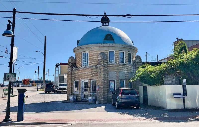
The land on which you are now standing is steeped in the history and tradition that is Oklahoma. Originally a part of the Creek Nation prior to statehood, this land supported a family grocery store along Route 66 for nearly four decades. Now it has . . . — — Map (db m171554) HM
John J. Leyh, a local grocer, constructed the two-story brick building in 1921 to house his store on the first floor and apartments above. Clerks from the grocery store often lived in the apartments upstairs. John and his wife, Maude, operated the . . . — — Map (db m170411) HM
Erected in 1934, the Meadow Gold sign stood above its rooftop perch at 11th Street (Historic Route 66) and South Lewis Avenue for nearly seven decades and served as a reminder of days gone by - days of the milkman and deliveries of dairy products to . . . — — Map (db m171552) HM
The concept of the neon lamp was invented by French engineer and chemist Georges Claude in 1902 when he discovered that by passing an electric current through inert gases he could make them glow very brightly. In 1911 Claude obtained international . . . — — Map (db m171555) HM
As automobiles became a popular mode of travel for
leisure-seekers, early "auto-enthusiasts" camped along the
roadside or in organized tourist campgrounds. Beginning in
the 1920s, motor courts and motels developed along busier
highways to . . . — — Map (db m142277) HM
While Route 66 followed 11th Street east and west of
downtown Tulsa, between S. Boulder Avenue and S. Elgin
Avenue it followed E. 10th Street. As was common all along
Route 66, auto-related businesses opened in locations
convenient to drivers. . . . — — Map (db m142237) HM
Demolished
William W. Bishop was already a successful restaurateur
when he opened Bishop's Restaurant at 5th Street and Main
Street downtown in 1930, but the success of that business was
greater than any of his previous ventures. . . . — — Map (db m200190) HM
The original alignment of Route 66, from its initial designation in 1926
until 1932, came into Tulsa from the east along 11th Street. At Mingo
Road, it turned north for about one mile until it reached Federal Drive,
now Admiral Place. Route 66 . . . — — Map (db m142260) HM
The historic Cyrus Avery Route 66 Memorial Bridge is the point where "east meets west on the Mother Road" - the point on the road where the landscape begins to change and the road seems to stretch out in anticipation of its long journey to . . . — — Map (db m172088) HM
The original 11th Street Bridge was constructed in 1916 as a Highway 64 crossing of the Arkansas River and as a way to connect downtown Tulsa with the rich oil fields west of the river. Unlike most bridges of the day, the beautiful art deco . . . — — Map (db m172091) HM
Cyrus Stevens Avery was elected Tulsa County Commissioner in 1913. The following year, he helped organize the Albert Pike Highway Association and was President for nine years during which the Association developed Highway 64 from Colorado Springs, . . . — — Map (db m172089) HM
Automobile dealerships required ample space for displaying,
testing, and repairing vehicles. The sparsely developed land
along this stretch of Route 66, more than three miles east
of downtown Tulsa, met that requirement.
Automobile . . . — — Map (db m200176) HM
For various reasons through the years, "pearls" along the national Route 66 highway were lost. Tulsa wishes to share with you examples of remaining nearby pearls on East 11th Street.
The former Hawk Dairy is located at 2415 East 11th Street. By . . . — — Map (db m171448) HM
If you were born after 1960, chances are you don't remember the milkman. Several generations ago, however, home milk delivery by the milkman driving a refrigerated truck was an integral part of the American morning landscape.
After World War . . . — — Map (db m171458) HM
When the United States entered World War II, Route 66 was a strategic transportation corridor that avoided the mountains and colder climates of the north. The Chicago-to-Los Angeles paved highway created a reliable means for transporting raw . . . — — Map (db m171457) HM
By 1917, the area surrounding this intersection was being developed for its natural resources: coal and oil. Coalmining and oil wells survived until the 1930s when the area developed as a primarily residential and commercial community.
One . . . — — Map (db m171449) HM
Opening in 1948 on the northeast corner of this intersection, the Golden Drumstick was a much loved comfort food restaurant specializing in fried chicken served with mashed potatoes, rolls, butter and honey. For two decades the "Drumstick," as it . . . — — Map (db m171452) HM
Texas RoadThe most ancient and important trail through Oklahoma Three Forks at the head of navigation of the Verdigris River the oldest trading post in Oklahoma dating from 1812.
Creek & OsageIndian agencies on the East and West banks of the . . . — — Map (db m52559) HM
The Great Western Cattle Trail began at Bandera, TX. As the demand for beef increased in the east, returning Civil War soldiers headed wild longhorn cattle from south Texas and Mexico north to the railhead at Dodge City, KS. The first herd . . . — — Map (db m120012) HM
Here, between 1874 and 1890, supply wagons, a daily stage coach and the U.S. Mail moved over this earliest known trail from Dodge City, Kansas to Fort Elliott, Texas. The fort, first known as "Cantonment on Sweet water" was established after the . . . — — Map (db m182287) HM
In 1870 a supply road was established between Fort Supply and the Cheyenne-Arapaho agency in Darlington, O.T. the road and telegraph line was built as an extension of the Fort Dodge KS - Fort Supply Trail and extended to Fort Reno in 1875. In . . . — — Map (db m214654) HM
124 entries matched your criteria. Entries 101 through 124 are listed above. ⊲ Previous 100