Near East 160th Avenue (East Bridge Street) (State Highway 7) just east of South 4th Avenue (State Highway 2), on the right when traveling east.
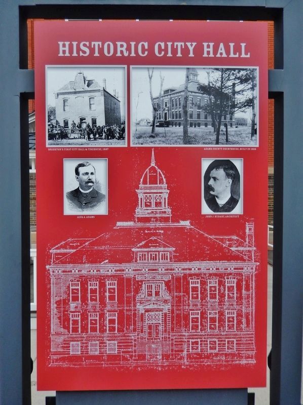
Historic City Hall was initially built as the first permanent Adams County Courthouse. The courthouse was designed in 1904 by architect John James Huddart, who also designed the Brighton Armory. In 1906, builder A.B. McDonald completed the . . . — — Map (db m203311) HM
On Main Street (U.S. 160), on the left when traveling west.
Designated
Landmark
City of Alamosa
Historic Registry
————————————
Dickey-Springer
Post No. 113
American Legion
Laid by
Charles G. Dawes . . . — — Map (db m160804) HM
On West Littleton Boulevard at South Court Place, on the right when traveling west on West Littleton Boulevard.
In the early part of the 20th century, Denver served as both the state capital and the Arapahoe County seat. An amendment to the Colorado Constitution creating a new City and County of Denver was passed by Colorado voters in 1902. This left . . . — — Map (db m130140) HM
Electricity was introduced in Salida in 1887 when a group of local townsfolk created The Electric Illuminating Company. In 1892 the then-named Salida Light and Power Company built a 1000-kilowatt steam generating plant at this location on the banks . . . — — Map (db m52403) HM
On Sixth Street at Taos Street, on the right when traveling west on Sixth Street.
William H. Cushman built this imposing brick Italianate commercial building in two phases. He completed the western part as a two-story structure in 1872. Three years later, Cushman built an adjoining three-story edifice on the corner lot; he . . . — — Map (db m173242) HM
On Sixth Street at Taos, on the right when traveling east on Sixth Street.
A Norman inn built in a great silver mining camp by a mysterious Frenchman called Louis Dupuy, opened in 1875, richly furnished from New York ad abroad, it became nationally noted for continental delicacies and the literary bent of its proprietor, a . . . — — Map (db m173300) HM
On Sixth Street at Taos Street, on the right when traveling east on Sixth Street.
Frenchman Louis Dupuy came to Georgetown in 1870 to seek his fortune in silver mining. A mine accident ended those dreams, and he soon opened the first phase of his extraordinary Hotel de Paris. The hotel, completed in 1890, featured steam heat, hot . . . — — Map (db m173301) HM
On Sixth Street at Rose Street, on the right when traveling east on Sixth Street.
John Tomay came to Georgetown in 1873 to oversee the properties of the Baltimore Tunnel Company. He became an insurance, real estate, and loan agent and remained in Georgetown until his death in 1922. This “large, jovial man” was also . . . — — Map (db m173302) HM
On Sixth Street at Rose Street, on the right when traveling west on Sixth Street.
This structure is one of the town’s oldest surviving wooden commercial buildings. Originally, it was a two-story structure that was about half the width of the present building. By 1874, the owners had doubled the size of the structure, creating a . . . — — Map (db m173427) HM
On Sixth Street at Argentine Street, on the right when traveling east on Sixth Street.
Now known as the Georgetown Community Center, this is one of the few two-story wooden commercial buildings remaining from the 1860s in Georgetown. Initially, builders John Fillius and J.G. Mahany had their Ohio Grocery and Bakery on the first floor, . . . — — Map (db m173428) HM
On Sixth Street at Griffith Street, on the left when traveling east on Sixth Street.
This firehouse, which features Italianate detailing, originally stored the equipment of the Star Hook and Ladder Company, which had formed in 1874. The “Star Hooks” had acquired a new long fire truck with ladders, hook stakes, and . . . — — Map (db m173299) HM
On Miner Street, 0.1 miles east of 15th Avenue, on the right when traveling east.
Mrs. Coddington owned a two-story brick double on the corner lot. It was occupied by W.K. Townsend (grocer) and Paul Lanius (hardware). Townsend imported glassware and crockery and was said to have the best selection of cigars in town. "Lets all . . . — — Map (db m76856) HM
On 3rd Street east of Main Street (U.S. 50), on the left when traveling east.
Built by Wm. R. Gale
Original location -
West side of alley facing East 3rd St.
between Main & Palmer
Moved in 1974 by
Delta County Historical Society — — Map (db m159566) HM
On 18th Street at Wynkoop Street, on the right when traveling north on 18th Street.
18th St. Atrium
1919
One of the last buildings constructed in "Warehouse Row," which stretched from Cherry Creek to the 1900 blocks of Wynkoop Street, 1621 18th Street originated as the warehouse and offices for Bourk, . . . — — Map (db m97346) HM
On Wazee Street at 19th Street, on the right when traveling north on Wazee Street.
Built in 1930-31 as a multi-tenant warehouse, 1863 Wazee Street is representative of the final building period in Lower Downtown until the boom of the 1980's. Architect Montana Fallis used the modernistic style to establish this building as Denver's . . . — — Map (db m97348) HM
This building was constructed by
madam Jennie Rogers in 1889 and became
the classiest bordello in the Rocky
Mountain West. Another famous pleasure
queen, Mattie Silks, operated the business
from 1911 until it was closed by federal
edict in . . . — — Map (db m96236) HM
Denver's Union Station was constructed to consolidate rail activity in the City and to replace the four separate stations serving the boom town. When completed in 1890 in an Italianate style of Colorado Rhyolite with sandstone trim, the station . . . — — Map (db m237358) HM
On Blake Street at 19th Street, on the left when traveling west on Blake Street.
Windsor Farm Dairy Building
1918
A building with a milky past, the Windsor Farm Dairy was built in 1918 for $30.000. A leading Denver architectural firm, Fisher & Fisher, designed this red brick structure with terra cotta . . . — — Map (db m97358) HM
On 16th Street at Wynkoop Street, on the right when traveling north on 16th Street.
For more than a century, Denver's warehouse district has centered on Wynkoop. Stimulated by the arrival of the railroads in 1870 and the subsequent need for distribution services, an impressive array of three-to-five story warehouses, flat roofed . . . — — Map (db m97395) HM
On Wynkoop Street at 16th Street Mall, on the right when traveling east on Wynkoop Street.
Constructed in 1896 for $75,000, the Morey Mercantile Building was the first notable warehouse to be built after the 1893 silver crash. Designed by Gove & Walsh, the structure included a spice grinding mill, roasting plant, extract laboratory and . . . — — Map (db m97396) HM
On Blake Street, on the right when traveling south.
The First National Bank of Denver made its first home here in 1866, with a building constructed for a cost of $45,000. The bank stayed at this location for 10 years, enlarging rooms, installing fancy gas lights, and in 1875, adding a third floor . . . — — Map (db m27508) HM
On 17th Street at Wynkoop Street, on the right when traveling north on 17th Street.
Originally built as the stables for the Denver City Railway Company in 1883, this building was the birthplace of Denver's Public Transportation system. Horse drawn trolleys, soon replaced by one of America's most extensive cable car networks, . . . — — Map (db m97394) HM
On 17th Street near Wazee Street, on the right when traveling south.
The Oxford Hotel, built in 1891, is Denver's Oldest Hotel. Bankrolled by Brewer Adolph Zang and his partners Philip Feldhauser and William Mygatt, the hotel was designed by Denver's greatest 19th century architect, Frank E. Edbrooke. Through the . . . — — Map (db m6674) HM
On 15th Street at Wynkoop Street, on the right when traveling south on 15th Street.
On the original site of the Washington Hotel and Studebaker Buggy and Carriage House, this building was constructed in 1906 as a four-story warehouse for the Spratlen-Anderson Mercantile Co. Frank Edbrooke designed the original structure, as well as . . . — — Map (db m97415) HM
On 17th Street at Blake Street, on the left when traveling south on 17th Street.
The St. Elmo Hotel, constructed in 1896, joined a pantheon of grand and small hotels clustered in lower downtown to serve railroad travelers. In 1870, the first Denver Pacific locomotive pulled into Denver, and prosperity followed close on its . . . — — Map (db m97391) HM
On Wynkoop Street at 15th Street, on the right when traveling north on Wynkoop Street.
This site has been home to:
1880 • The Washington Hotel
1896 • Studebaker Buggy & Carriage Works
1902 • The Spratlen-Anderson Wholesale Grocery Company
1923 • Davis Brothers Drug Company
1957 • Lande Manufacturing
1990 • Edbrooke . . . — — Map (db m97417) HM
Has been designated a Registered National Historic Building under the provisions of the Historic Site Act of 1935. This site possesses exceptional value in commemorating or illustrating the history of the State of Colorado United States Department . . . — — Map (db m47192) HM
Near 17th Street, on the right when traveling south.
In 1915, this was the Colorado National Banks slogan.
Designed by W.E. and A.A. Fischer, the buildings bronze vault and door weighs 73,000 lbs with supports walls three-and-a-half inches thick. Inside the vaults, the doors alone weigh 62,000 . . . — — Map (db m135451) HM
On 17th Street at Arapahoe Street, on the right when traveling south on 17th Street.
The D&F Tower at the corner of 16th and Arapahoe Streets is all that remains of the Daniels & Fisher department store that stood on this block.
After its construction in 1911, the D&F Tower was for many years the tallest building in Denver. . . . — — Map (db m135103) HM
On 17th Street at Curtis Street, on the right when traveling south on 17th Street.
The Silver Panic of 1893 brought 17th Street to her knees. Eventually she recovered; gold was the reason she survived. Golden riches arrived from the mines of Cripple Creek filling Denver's coffers.
This Golden Era is symbolized by the gold . . . — — Map (db m135105) HM
Near 17th Street, on the right when traveling south.
Constructed in 1890-92, the Equitable Building is on the National Register of Historic Places. It has long been home to many of Denver’s most prestigious law firms and financial institutions, and is generally regarded as the last great building . . . — — Map (db m135472) HM
Near 17th Street at Stout Street, on the left when traveling south.
Clark, Gruber and Company printed gold notes as well as producing $2.50, $5 and $20 gold pieces.
After private mints were outlawed in 1864, the federal government took over the job as the Denver Mint.
Clark, Gruber and Co. evolved to . . . — — Map (db m135483) HM
Near 17th Street at Curtis Street, on the left when traveling south.
The Skyline Urban Renewal Project consisted of twenty blocks between Curtis Street and Larimar Street that were demolished in the late 1960s to “remove blight” and make way for the new and modern. There is a noticeable difference in scale between . . . — — Map (db m135445) HM
Near 17th Street, on the left when traveling south.
Charles Boettcher (1852-1948) was a German immigrant who played several key roles in the state’s economic development. He introduced the sugar beet industry to Colorado and established the Great Western Sugar Company.
While building sugar . . . — — Map (db m135478) HM
Near 17th Street at Glenarm Place, on the right when traveling south.
17th Street earned this title long ago based on its status as the business and financial center of the Rocky Mountain Region. Many consider 17th Street the “right address” for business success.
Denver’s major banking institutions, brokerage . . . — — Map (db m135513) HM
On Osage Street at West 10th Avenue on Osage Street.
In November 1893, Henry H. “Shorty Scout” Zietz opened a saloon in this building, which was built about 1886 by Neef Brothers Brewery. Known as the Rio Grande Exchange, the saloon catered to the railroaders working across Osage Street at . . . — — Map (db m51709) HM
On Fourth Street at Wilcox Street, on the right when traveling west on Fourth Street.
This property has been
placed on the
National Register
of Historic Places
by the United States
Department of the Interior
Second plaque
This property
has been designated as a
Historic . . . — — Map (db m120800) HM
Near East Valley Hi Drive at Parker Road (Colorado Highway 83).
In September of 1911, Fredrick B. Hood had come to Parker not only as a stock holder in the newly formed Parker State Bank, but to serve as the bank's cashier and manager as well. He purchased land on what was then called Rural Road (now Pikes Peak . . . — — Map (db m97575) HM
On Colorado Avenue west of South 24th Street, on the right when traveling west.
One of the earliest structures in
Colorado City, this false-fronted
log cabin was built in 1859 by
Dr. James Paul Garvin at 2608
West Colorado Avenue. In 1861,
the first Territorial Legislature met
in Colorado City, a candidate . . . — — Map (db m201139) HM
On Colorado Avenue west of South 24th Street, on the right when traveling west.
This tablet is the
Property of the State of Colorado
———
Log house from Colorado's first designated territorial capital, at Colorado City (now a part of Colorado Springs). This log log house was built in 1859. . . . — — Map (db m200386) HM
On East Main Street, on the right when traveling south.
A visit to Elizabeth’s Main Street reveals some older building still used for day-to-day business, but it might surprise you to learn that many of these stores have been features of the Elizabeth scene for far more than a century!
Start at the . . . — — Map (db m45757) HM
On West Main Street at South Pikes Peak Avenue, on the left when traveling west on West Main Street.
The original two story business building at the corner of S. Pikes Peak and
W. Main St,, built with local white
brick from Pueblo and white stone
trim from Norman McKay's quarry,
was considered "the handsomest and
most pretentious building in . . . — — Map (db m232407) HM
On West Main Street (Colorado Route 115) west of Pikes Peak Ave (Colorado Route 67), on the left when traveling west.
This building, erected in (approx.) 1893, housed a
dry goods store operated by J.H. Dils. By January,
1897, Robert A. Ramsey purchased the stock and
business of Dils for his Golden Rule Store, managing the business himself. Golden Rule Stores . . . — — Map (db m232413) HM
On West Main Street (Colorado Route 115), on the right when traveling west.
This property has been used for many
businesses. In 1895 it housed a grocery
store. By 1900 "The Fair" store was
housed in this building. A harness shop
owned by Henry J. Owens was located
here in 1906, with R.H. Paton, M.D.
conducting his . . . — — Map (db m232476) HM
On West Main Street (Colorado Route 115), on the right when traveling west.
Thomas Carmondy was the original owner
and his business advertised furniture, carpets,
Queensware and undertaking services. The
embalming room was described as having
"every latest improvement", and his other
stock "is unexcelled by any of its . . . — — Map (db m232475) HM
On West Main Street (Colorado Route 115) west of North Pikes Peak Avenue (Colorado Route 67), on the left when traveling west.
This building was originally
constructed to house the Florence
Firehouse and City Hall.
Built in late Victorian style, the
building was the location of the
Florence City Hall from 1892
until 1920. It housed a jail, the
mayor's office, . . . — — Map (db m232382) HM
On West Main Street (Colorado Route 115) west of North Pikes Peak Avenue (Colorado Route 67), on the left when traveling west.
127 Constructed in 1899 & 125 in 1915. Architect: Unknown Builder/Contractor: Henry Lewis
The West portion of the now
conjoined building, 127 West Main was
built for Mr. William G. Ricketts in
1899, beginning life as a . . . — — Map (db m232419) HM
On West Main Street (Colorado Route 115) west of North Pikes Peak Avenue (Colorado Route 67), on the left when traveling west.
Estimated to have been built in 1885 for owner, Van Nest (likely
Albert J. Van Nest), likely lived on the second floor along with
his wife and five male lodgers. It is not known what type of
business operated on the main floor at first. By 1901, . . . — — Map (db m232416) HM
On West Main Street (Colorado Route 115) at South Santa Fe Avenue, on the right when traveling east on West Main Street.
The building was built by George Wilson to
house his hardware store on the first floor and
his residence and hotel on the second floor. He
and his wife, Emily, and their four children
lived in the building.
George was a two-time mayor of . . . — — Map (db m232421) HM
On 8th Street at Grand Avenue (State Route 82), on the right when traveling east on 8th Street.
On March 15, 1887, excavation for a three-story brick and stone building began on lots at 802 Grand Avenue for the First National Bank building. At the time, The Glenwood Echo newspaper reported that the First National Bank offices would occupy the . . . — — Map (db m120089) HM
On Grand Avenue (Colorado Route 82) at 8th Street, on the right when traveling south on Grand Avenue.
The Citizens National Bank Building stands as Glenwood Springs landmark.
The Citizens Building and Improvement Company was founded in 1910. Construction of the Citizens National Bank Building began in January, 1913. The building was completed . . . — — Map (db m120085) HM
On 7th Street east of Cooper Avenue, on the right when traveling east.
In the late 1800's to the early 1900's, saloons, restaurants, and rooming houses occupied this block. In 1904, Frank Walter constructed two buildings - one three-story - in the block. Walter leased the ground floor of the three-story building (406 . . . — — Map (db m120084) HM
On Grand Avenue (Colorado Route 82) north of 9th Street, on the right when traveling north.
The commercial building at 824-826 Grand Avenue was constructed in 1888. The brick building was initially occupied by a hardware store and an agricultural implement shop on the first floor, furnished rooms on the second floor, and a tin shop in the . . . — — Map (db m120102) HM
On Grand Avenue (Colorado Route 82) south of 8th Street, on the right when traveling south.
Sovereign Grand Lodge of Independent Order of Odd Fellows (I.O.O.F) working hard to establish their own permanent meeting place.
After being in many different locations in the downtown, the began construction of their new lodge in 1898. The . . . — — Map (db m120086) HM
On Grand Avenue (Colorado Route 82) at 9th Street, on the right when traveling south on Grand Avenue.
This current address has incorporated numbers 827 and 829 Grand Avenue. The earliest maps show buildings on this site since 1888, but the year 1913 has J.F. McCoy constructing his building. In 1917, the State of Colorado purchased the building for . . . — — Map (db m120087) HM
On 7th Street at Blake Avenue, on the right when traveling east on 7th Street.
This site - Lot 9 Block 45 - housed what in later years would be known as the Rex Hotel. Glenwood Springs founder Isaac Cooper first owned the property, but between 1887 to 1892, ownership changed hands several times. During this time, several small . . . — — Map (db m120082) HM
On 7th Street east of Cooper Avenue, on the right when traveling west.
In 1906 Henry Bosco had a whole liquor and Coca-Cola bottling business operating in the basement of a saloon at 414 Seventh Street. Within a few years, Henry purchased the building that housed his business and the adjacent lot to the east. In 1915, . . . — — Map (db m120083) HM
On West Main Street at North 5th Street, on the right when traveling west on West Main Street.
In 1893, this two-story building served as a general merchandise establishment. Daniel Barry operated his business here until 1897. Cohn, Doll & Co (later Doll Bros. and Smith) operated a dry goods and general merchandise store here, followed by the . . . — — Map (db m120103) HM
On West Main Street at Vandeventer Avenue, on the right when traveling east on West Main Street.
In the early days of New Castle, horses were at the center of all activity. The building before you was where that activity happened. C.H. Noren & Son, who rented horses and rigs for hauling, operated the livery business. Later Levi Strauss and A . . . — — Map (db m120105) HM
On West Main Street at North 5th Street, on the right when traveling west on West Main Street.
The Independent Order of Odd Fellows insignia still appears on the façade of this building, built in 1990. As with many early buildings, the ground floor was used for commercial purposes. Here the ground floor was occupied by a saloon, later by J.W. . . . — — Map (db m120119) HM
One of Black Hawk’s newer buildings, the 1896 structure was built by Julius Kline (or Klein), replacing an earlier wood building that was the site of Black Hawk’s first school. It operated sporadically throughout the 20th century under a variety of . . . — — Map (db m51882) HM
On Main Street (State Highway 279) at Spring Street on Main Street.
The Central City Opera House was built in 1878 by Welsh and Cornish miners. This National Historic Landmark, centerpiece of the historic gold mining town of Central City, has hosted performances of the nation’s fifth-oldest opera company since 1932. . . . — — Map (db m51831) HM
The major fire in Central City on May 21, 1874 nearly wiped out the commercial district of the city. The new building was completed by November 1st of the same year and B.F. Pease operated a dry goods store at the location for nearly 10 years. For a . . . — — Map (db m51834) HM
On Grand Avenue east of Pitkin Street, on the right when traveling east.
In 1881 James Cairns built his first store here to serve the miners. In 1908 he replaced it with a better building, purchased by Matilda Humphrey in 1924. It survives as the central part of the Humphrey store. The small residence was Cairns interim . . . — — Map (db m129850) HM
Near Trail Ridge Road (U.S. 34) 0.2 miles east of Western Road (County Highway 49), on the right when traveling east.
Grand Lake Lodge Built 1919
has been placed on the National Register
of Historic Places
by the United States Department of the Interior
— — Map (db m129878) HM
On Lake Avenue, 0.1 miles west of Hancock Street, on the right when traveling west.
Ezra Kauffman first came to the area as a hunting guide and miner in 1877. After the mines closed, he raised his family in the community he loved. He completed this hotel in 1892 and operated it until his death in 1920. The Kauffman family . . . — — Map (db m129856) HM
On Grand Avenue east of Garfield Street, on the left when traveling east.
When the town of Grand Lake was platted in 1881, Grand Avenue was designed to be 100 feet wide. Although traffic congestion was not a problem, extra space was allowed for rodeos and horse races.
The Public Square was often used for community . . . — — Map (db m129840) HM
On Hancock Street north of Park Avenue, on the right when traveling north.
Rapids Lodge is one of three tourist hotels built between 1900 and 1920. The other two burned. Laps Ish, the owner and builder, sawed all lumber of lodgepole pine. Until about 1935 the lights and some heat for the hotel came from his own water . . . — — Map (db m129852) HM
Near Vine Street north of Lake Avenue, on the left when traveling north.
The Smith Eslick Bay Window Cottage was built by the Eslick's youngest child, Loren, in 1933 when he was 26 years old. It was intended to be a check-in and store for the guests staying at the Cottage Court and other Smith and Eslick family cabins . . . — — Map (db m129884) HM
On Main Street (State Highway 135) north of Tomichi Avenue (U.S. 50), on the right when traveling north.
This property
has been placed on the
National Register
of Historic Places
by the United States
Department of the Interior
————————————
Gunnison County . . . — — Map (db m158795) HM
The Colorado Transcript, Colorado’s second oldest newspaper, began here on November 24, 1866. General Gorge West, a Civil War veteran, and one of the founders of Golden and the Colorado School of Mines, started the paper. Constructed in 1870, it is . . . — — Map (db m49892) HM
The original building was constructed in 1870 by John H. Parsons and William H. Curry as the City Restaurant Hotel for an Italian immigrant Charles Garbarino. It originally had arched windows and doors on both floors and an ornate wood balcony used . . . — — Map (db m49890) HM
Near Tenth Street east of Washington Avenue, on the right when traveling west.
City of Golden
Downtown Landmark
The Golden High School was dedicated in March 1924. Built on the site of the Eagle Corral and Stables, the school was hailed as the ultimate in high school construction. Designed by renowned Denver architect . . . — — Map (db m50592) HM
On Washington Avenue north of 11th Street, on the right when traveling north.
City of Golden
Downtown Landmark
The Stewart Block building was completed in 1892. It served as a grocery for 52 years under a variety of owners including Caleb E. Parfet, Elvyn E. Stewart, and Leonard Vogel. The motto of the original building . . . — — Map (db m50593) HM
On 11th Street at Arapahoe street, on the right when traveling west on 11th Street.
To the south on Arapahoe Street is a distinctive building made of river rock. The Armory was completed in 1913 to house Company A Engineers of the Colorado National Guard, comprised of Colorado School of Mines students. Designer James H. Gow, who . . . — — Map (db m111389) HM
171 entries matched your criteria. The first 100 are listed above. The final 71 ⊳