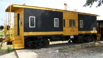
This Caboose was used by the Southern Pacific Railroad. Train crews lived in the caboose as the train traveled across the country. The bay window style allowed the crew to watch the train for any problems while riding. This caboose is on loan to . . . — — Map (db m34710) HM
Robert Alexander Long in 1875 established his first lumber yard at this site. Fifty years later Long-Bell lumber company was the largest lumber company in the world.
www.ralonghistoricalsociety.org — — Map (db m96967) HM
In 2001, members of the community joined with the Galena Chamber of Commerce to donate a block of the downown Route 66 main street to construct a park for everyone to enjoy.
Route 66 Howard "Pappy" Litch Park
The Oldest Mining Town in . . . — — Map (db m43047) HM
Named for the ore it produced, Galena lead mining was the largest industry in our history, starting in 1873 and continuing until 1973. The mining and smelting required 3 railroads, 65 crushers, 2 smelters and 3 sludge mills to handle the ore . . . — — Map (db m43035) HM
As an important mining town, Galena had
numerous mines and smelters, but none
was more important than the Eagle-Picher
smelter plant north of the pre-1940s Route 66
alignment. The facility operated from around
the late 19th century until 2004 . . . — — Map (db m161632) HM
For many years, a large garage/service station stood at this location.
The owner, Howard "Pappy” Litch, was an avid Galena historian.
"Pappy” spent much of his life promoting his hometown and saving
its history. To honor him for . . . — — Map (db m161633) HM
Geological remnants of Mississippian times are found in the limestone cave region of the 55 square mile Ozark Plateau in the very southeast corner of Kansas. The cherty limestones of the area were developed in marine environments during the late . . . — — Map (db m61154) HM
This 1.2-mile section of roadbed is the most intact section of the original U.S. Highway 66 (Route 66) in Kansas. It was first paved around the turn of the century using macadam made from the waste products of the nearby mines. Prior to its federal . . . — — Map (db m170666) HM
In less than 14 miles, this byway connects 3 towns, each with its own American success story.
The towns that dot Kansas Historic Route 66 were each poised for great success at the time the highway was designated in 1926. Galena was a major . . . — — Map (db m81118) HM
The people of the Cherokee Nation left a lasting legacy to this corner of the State.
The 1836 Treaty of New Echota forced the removal of the Cherokee Nation from lands east of the Mississippi to the new Indian Territory. In addition to the . . . — — Map (db m81141) HM
You stand just miles north of one of Kansas' oldest highways: the Black Dog Hunting Trail.
In order to provide a supply route between seasonal hunting grounds, the indigenous people of the Osage Nation blazed a trail in the first decade of . . . — — Map (db m81145) HM
The waters of the Spring River and its tributaries have shaped this land and its settlement.
The Spring River and the waters that feed it, such as Brush, Shoal and Short Creek, carve their way through this corner of Cherokee County. For . . . — — Map (db m81100) HM
The City of Treece, located ½ mile west of Hwy. 69 was founded on February 26, 1918 as a result of mining operations in the early 20th century. During prime mining industry production; Treece, neighboring Picher, Oklahoma and several other small . . . — — Map (db m82092) HM
This dipper bucket will hold 40 cubic yards of dirt and rock. It was donated by the Peabody Coal Company from their Roger County Mine #2 near Vinita Oklahoma. The dipper came off a Model 5561 (Marion) Coal Shovel. The weight of the dipper, as it . . . — — Map (db m39741) HM
With the discovery of coal in Cherokee and Crawford Counties in the late 1860's, thousands came to work the mines. Some came from American towns and cities but most were immigrants from Europe. Over fifty nationalities settled in this area. Many . . . — — Map (db m39738) HM
George Jacobs Ducrow was born into a circus. His earliest memory was training with L.B. Lents New York circus. However, his time there was not all fun and games. In 1873 he was badly injured in a fireworks accident and was blind for three months. . . . — — Map (db m212532) HM
Holly Leroy Stoll was born in Tompkins County, New York to alcoholic parents. He and his younger sister Marie were removed from that home after an uncle reported their neglect. Marie was placed with a grandmother and Holly was put in an orphanage. . . . — — Map (db m185731) HM
James Reed was born in Upstate New York to Fred and Gertrude Reed, the second child of four. At the age of four, James and his two siblings lost their parents and eldest sister, Ethel. The three had been moving cattle across a frozen lake when the . . . — — Map (db m185966) HM
Born in Brooklyn, New York, John was turned over to the care of the New York Child's Hospital by his mother on July 22, 1912. At 2 ½, John was transferred to the care of the Children's Aid Society of New York. John was placed out in Ottawa, Kansas, . . . — — Map (db m212486) HM
During the Orphan Train Movement, the state of Kansas received an estimated 12,000 children from East Coast orphanages. The Children's Aid Society placed out over 5,000 children, the New York Foundling Hospital sent an estimated 5,000 children and . . . — — Map (db m212695) HM
Paul Young was a three year-old, freckle-faced, red-haired boy who was taken in by Concordia residents Boyd and Louise Clithero. The Clitheros owned a grocery store and apartment buildings (including the brick apartment building, Keystone . . . — — Map (db m185729) HM
The Cornell Brothers and their younger sister Elouise were born in Elmira, New York, to Floyd and Lottie Cornell. In 1925 Lottie passed away from tuberculosis. Elouise was taken in by relatives; the boys were surrendered to the Children's Aid . . . — — Map (db m185734) HM
In 1874, the Children's Aid Society (CAS) created the Family Emigration Program to expand their Placing Out Department. The object of the program was to help destitute families get a new start outside the city while keeping the families intact. . . . — — Map (db m212589) HM
Louis was born in New York City to John Henry and Florentine (Goldig) Meyer. After the death of his mother, John was unable to care for the children, so he turned Dorothea and William over to the Episcopalian Orphanage. Amelia helped him with . . . — — Map (db m185999) HM
Architecture
Carnegie Free Library est. 1912
——————
Art
Sunflowers in Coffey County
——————
Commerce
Wolf Creek Nuclear Power Plant . . . — — Map (db m50030) HM
Restoration Capital and
Pressed Metal Ceiling Capital
of Kansas
Centennial 1857-1957
Sesquicentennial 1857-2007
Bi-Centennial 1857-2057
Fernando Augustus Atherly
1835 - 1904
First Mayor of Burlington
Elected 1870
Amarette . . . — — Map (db m50068) HM
Marion Ellett Budd was a country printer who ranked with the best craftsmen in the printing industry. Most Easy came to Burlington on Sept. 1st, 1877. His Runt Park, as he called his place in Burlington, attracted thousands of curiosity seekers . . . — — Map (db m80312) HM
Born in Waverly on Sept. 24, 1903, she co-founded Beech Aircraft Company in Wichita, Kansas, in 1932, with her husband Walter Beech. She played a vital role in the company and after his death in 1950, she led Beech Aircraft Corporation, until her . . . — — Map (db m89320) HM
Owners
S. H. Jennings: 1901-1918
F. M. Benson: 1918-1920
Andrew Wilson: 1920-1941
E. H. Ruppelius: 1941-1974
Dorothy Fisher: 1974-1978
Joseph & Elizabeth Sears: 1978-1994
Elizabeth Sears Trust: 1994-
Occupants
Unknown: . . . — — Map (db m60528) HM
This corner marks the spot where in 1869 Colonel E. C. Manning placed the stake from which the City of Winfield was laid out. The first building in Winfield, Colonel Winfield's old log store, stood on this corner. In 1885, Henry Goldsmith . . . — — Map (db m60527) HM
By 1936, the progress of building the dam was greatly accelerated with the arrival of new heavy equipment. The men now had excavators, dump trucks, caterpillar tractors, box sleds, and a pull-type grader.
The CCC camp had storage sheds for . . . — — Map (db m50234) HM
Proof of how hard times were during the Great Depression, this CCC recruiting poster depicts a young man wearing a clean, pressed uniform with a plate of food. Another incentive to enroll into the CCC was a $30.00 a month salary with $25.00 . . . — — Map (db m50192) HM
Moved to present location
September 12, 2012
Designed for applications that require blasts of air for long distances. Used in coal mining industry to force fresh air into the shafts. — — Map (db m72361) HM
Moved from Chicopee to present location
July 19, 2012
The hoist had cables on the drum that were used to raise and lower coal cars from the mine, Circa Late 1800s-Early 1900s — — Map (db m72362) HM
Used in strip-mining operations to remove the overburden of soil from coal seams.
Owned by Wilkinson Coal Company
Donated by Wendell & Lynda Wilkinson
Dedicated January 13, 2013 — — Map (db m72353) HM
Constructed in 1936 with federal funding assistance, the Franklin Sidewalk connects two rural mining communities in Crawford County - Franklin and Arma. The 3' wide sidewalk stretches 1.7 miles. It has become well known as the "longest sidewalk . . . — — Map (db m72352) HM
owned and operated the Pritchett Insurance and Real Estate Agency in Pittsburg, Ks. for more than 50 years.
This park is one of the results of a trust they established with a mission to improve the quality of life in Pittsburg and Crawford . . . — — Map (db m36831) HM
Among the many significant European immigrants in Kansas history is Alexander Howat, President of District 14 of the United Mine Workers of America. He was chiefly responsible for the organization of a powerful and militant union membership in the . . . — — Map (db m35668) HM
Frontenac, Kansas first came into being when the coal mining industry moved into the area during the late 1800s. The Santa Fe Railroad leased the land around what is present-day Frontenac, and formed the Cherokee and Pittsburg Coal and Mining . . . — — Map (db m35604) HM
H.R. Browns Grocery was one of the last neighborhood grocery stores in Pittsburg, Kansas. By 1912, there were seventy-nine retail grocery stores in Pittsburg. Their strength was in their relative convenience for their customers. Regular customers . . . — — Map (db m84741) HM
During the latter half of the 19th century and the early part of the 20th century a diverse population of European immigrants came to Southeast Kansas in search of a better life. The first view of Pittsburg for many was from the depot of the Frisco . . . — — Map (db m34247) HM
Locomotive 488 was built July 1906, in Pittsburgh, Pa. In 1925, it underwent major changes in Pittsburg, Ks. and changed to Locomotive 1023. Track was laid and locomotive was installed in Schlanger Park on September 17, 1955, after the city had . . . — — Map (db m69838) HM
Founded in 1876 on lands formerly held by the Cherokee Indian Nation. Pittsburg became an early center for railroads, lead and zinc smelting, coal mining, clay tile and mining machinery manufacturing. The Kansas State Teachers College was . . . — — Map (db m41989) HM
Phase One: Pioneer Mining
The coal fields of Cherokee and Crawford Counties covered over 300 square miles of land, making it a prime area for coal mining. When early settlers first moved into the area in the 1800's, they were amazed to see . . . — — Map (db m35571) HM
The women’s march of 1921 epitomizes the spirit of the Kansas Balkans, an area known for its rich cultural heritage and turbulent strike-ridden history. On December 12 of that year, 3,000 (by some reports up to 6,000) women—wives and other . . . — — Map (db m35692) HM
With the discovery of coal in Cherokee and Crawford Counties in the late 1860's, thousands came to work the mines. Some came from American towns and cities but most were immigrants from Europe. Over fifty nationalities settled in this area. Many . . . — — Map (db m35522) HM
The 1st Deep Mine, Scammonville, KS
In 1874 four brothers from Illinois, the Scammon brothers, pioneered new methods of mining coal in southeastern Kansas, digging the first mine shaft in Cherokee County. Although many doubted that their . . . — — Map (db m35605) HM
• William Wilkinson was born in Pelton Fell, England in 1862. He worked in the mines from the age of 10 and came to Weir City, Kansas, in 1883 at the age of 20 to continue mining.
• In 1917, he started his own deep mine a mile south of . . . — — Map (db m35606) HM
This shovel was donated by Wilkinson Inc in order to create a permanent symbol of our southeast Kansas coal mining heritage
McNally Pittsburg Inc was responsible for the relocation and renovation of the shovel to its present condition
July 4 . . . — — Map (db m41990) HM
Completed in 1880 the Lebold Mansion was built by C.H. Lebold a local banker, realtor, politician, and entrepreneur. Lebold chose the site of Abilene's first log cabin to build his 23 room home of rough hewn brown limestone blocks, from Russell . . . — — Map (db m49550) HM
The Abilene community would have taken a much different shape had it not been for the influence of C. L. Brown. Known as an industrialist, utilities magnate, financier, philanthropist, and organizing genius, Brown was responsible for the formation . . . — — Map (db m48496) HM
At the end of the Civil War when millions of longhorns were left on the plains of Texas without a market, the Union Pacific was building west across Kansas. Joseph McCoy, an Illinois stockman, believed these cattle could be herded north for . . . — — Map (db m43945) HM
A familiar trend of the early Abilene days was for a local businessman to have interests in several aspects of the economy. One such pioneer Abilene merchant was John Edward Johntz. He, along with other noteable businessmen of the time, had an . . . — — Map (db m49533) HM
This post commemorates and marks the first terminus of the old Chisholm Cattle Trail, which extended from Brownsville, Texas, some 1,000 miles to the south. This post is identical to 400 Trail posts placed across Oklahoma (Indian Territory) by Bob . . . — — Map (db m49632) HM
Completed in 1903, this building once was owned by T.E. Dewey and was known as the Brady Building. In 1904, following a disastrous flood, the building was sold to Cleyson L. Brown, Abilene entrepreneur whose many enterprises provided employment for . . . — — Map (db m49529) HM
The 34th president of the United States, Dwight David Eisenhower, grew up in Dickinson County. His parents, David and Ida Eisenhower, moved to Hope, about 10 miles west of here, in 1885. There, the Eisenhowers opened a general merchandise store . . . — — Map (db m236561) HM
In White Cloud 25 years ago Wilbur Chapman, a 10 year old boy raised and sold a pig 'Pete' to help support a leper boy. His example started the Pig Bank Movement. 100,000 banks have been distributed to date. 'Feeding' these banks is helping rid . . . — — Map (db m47396) HM
Completed in 1897, Charles Lothholz was responsible for construction of this building. The original businesses at this location included the Kaw Valley State Bank, a general store and a barber shop. The second story with a 250-seating capacity was . . . — — Map (db m76474) HM
This building, commonly referred to as the Pilla Building, has been an enduring Eudora landmark. Built in 1873, it housed the Pilla General Store until 1929, which was one of the largest and most prosperous businesses in the community. Numerous . . . — — Map (db m76486) HM
This building was renovated to its current appearance in 1892 when it became home to the Eudora State Bank. This unique building contains a large, ornate metal cornice on its exterior facing Main Street. The Eudora State Bank remained at this . . . — — Map (db m76440) HM
This building was constructed in the early 1870's and became home to the Eudora Chapter of the International Order of Odd-Fellows, a fraternal organization first chartered in 1869. As of 2012 the Odd-Fellows continue to own this building and hold . . . — — Map (db m76466) HM
This large brick building is perhaps the most versatile on all of Main Street. Constructed in the early 20th century, the building has been used for drycleaners, barber shops, cafes, undertaking services, watch repair shops, jewelers, shoe stores, . . . — — Map (db m76467) HM
The current structure at 719 Main dates to the early 20th century. In the building's early days, it was used as a barber shop and a furniture warehouse. In the last several decades, the building has been home to numerous restaurants, most notably . . . — — Map (db m76468) HM
J. A. Seybold was responsible for the construction of the buildings at 720/722 Main Street in 1883. Seybold operated a hardware store here for only a short time. The buildings were next used by W. A. Fuller and his "Yankee" Fuller Hardware Store . . . — — Map (db m76473) HM
This building was completed around 1915 when the Trefz Variety Store was founded by William Trefz. Carl Trefz later operated the store until 1976. Numerous businesses including hardware stores, antique stores and coffee shops later operated at . . . — — Map (db m76471) HM
This building was completed in 1891 to serve as home for the Eudora branch of the Ancient Order of United Workers (Lodge #112). The Eudora branch of the Ancient Free and Accepted Masons (Doric Lodge #83) started to meet at this location in the . . . — — Map (db m76470) HM
The current building at this location was built in 1917. This building has been home to hardware stores, grocery stores, garages and auto dealers, including Rothberger Motor Auto Sales. Since 2001 the building has been home to Quilting Bits and . . . — — Map (db m76489) HM
This building's origins date to the early 20th century, although the exterior appearance of the building has since been heavily altered. Numerous meat markets and butcher shops have called this building home, including: The Henry Hagenbuch Meat . . . — — Map (db m76488) HM
This residence likely dates to the 1860's. James Still, son of Wakarusa Mission (which served the local Shawnee Indians in the 1850's) founder Abraham Still, had his medical office here. In addition to being a doctor, James Still was also a . . . — — Map (db m76490) HM
Shawnee Tribal Leader Paschal Fish and his daughter, Eudora
This statue has been created to commemorate the 150th anniversary of the City of Eudora (1857-2007). The statue portrays Shawnee Tribal Leader Paschal Fish and his daughter, . . . — — Map (db m239853) HM
Constructed in 1912 for Perkins Loan and Trust Company 1912-1914
Kansas Electric Power Company (later Kansas Power & Light) 1924-1960
Douglas County Title Company 1977-1996 — — Map (db m76298) HM
This circa 1866 building is reflective of commercial Victorian architecture
Location of boot and shoe shop, grocery, agricultural implement dealer, and cigar shop
Charles Achning established a hardware store here by 1886. Business retained . . . — — Map (db m76171) HM
Constructed ca. 1866 to house Sutliff Clothier. This typical commercial block held Hutson Bakery 1886-1893, Anderson Confectionary 1893-1913
Facade altered in early 20th century — — Map (db m76297) HM
Built 1858-1860 for Josiah Miller Survived Quantrill's Raid, August 21, 1863. Facade altered 1921. Jacob House and descendants, clothiers, occupied this site 1862-1935. — — Map (db m76208) HM
Constructed late 1860s.
Alexander Marks, jeweler, was an early occupant
This building, now reflective of Mission style, housed dry goods, drugs, and jewelry businesses and several barber shops.
Alfred A. Lawrence Photography Studio . . . — — Map (db m76209) HM
This building has housed a variety of commercial enterprises since the mid 1860's including a grocery, clothier, and tobacco shops
Sol Marks began operating a jewelry store on this site in 1880 — — Map (db m76172) HM
Barteldes Seed Company
1888-1963
One of the first sites rebuilt after Quantrill's Raid in 1863
Interior destroyed by fire 1997
Restored 1997-98
Though modified several times,
the Italianate store front
retains many original . . . — — Map (db m76303) HM
Building constructed in 1866 to house a drug store founded by B. W. Woodard in 1855
Oldest drug store in Lawrence and Kansas in continuous operation. — — Map (db m76185) HM
The Fraternal Aid Society built a three story building on this site in 1904
Fire substantially destroyed the structure in 1930
Standard Mutual Life Insurance Company reconstructed this Renaissance Revival style building and occupied it from . . . — — Map (db m88887) HM
The curved brick wall to your right is the outside wall of our twenty-five ton wood-fired oven. The masonry circle continues inside the bakery. The oven itself is from J. Llopis of Barcelona, Spain, and was built on site by master craftsman Manuel . . . — — Map (db m54567) HM
Wiedemann's, a popular candy and ice cream store, operated on this site from 1886-ca.1943
Prominent social center, tea room and dance hall
The Jay Shoppe Ladies fashions 1952-1989 — — Map (db m76168) HM