On M Street Southeast at 4th Street Southeast, on the right when traveling east on M Street Southeast.
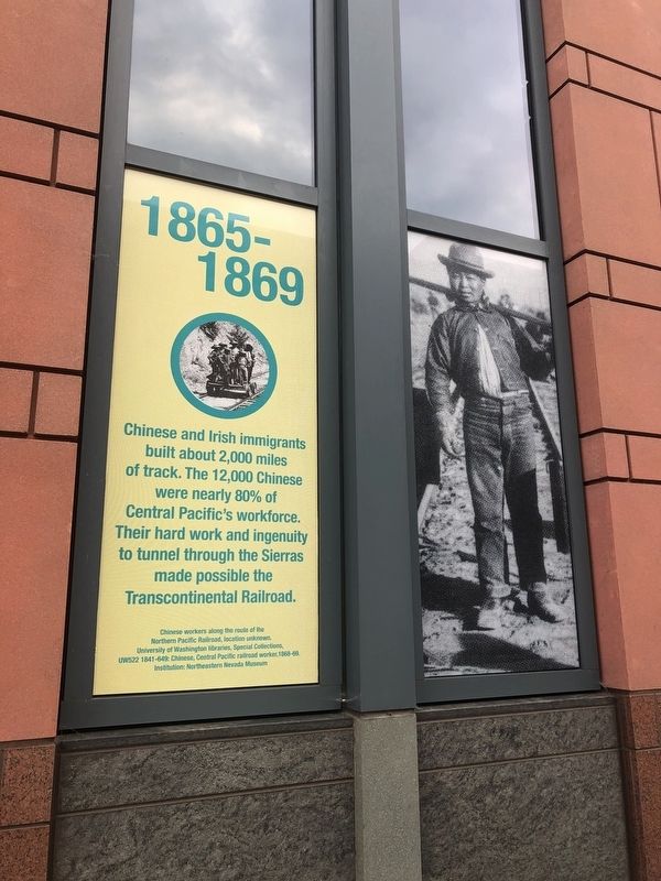
Chinese and Irish immigrants built about 2,000 miles of track. The 12,000 Chinese were nearly 80% of Central Pacific's workforce. Their hard work and ingenuity to tunnel through the Sierras made possible the Transcontinental Railroad. — — Map (db m170380) HM
On M Street Southeast west of 4th Street Southeast, on the right when traveling east. Reported permanently removed.
Theodore Judah's lobbying and surveying efforts are rewarded when the Union Pacific and Central Pacific railroads are joined at Promontory Summit, Utah Territory. — — Map (db m112749) HM
On M Street Southeast west of 4th Street Southeast, on the right when traveling east.
At 4 in the morning, Andrew Smith Hallidie successfully tests the cable car in San Francisco, the first to be put in regular service. Moving cables pull the cars up and down steep hills. — — Map (db m112753) HM
On M Street Southeast west of 4th Street Southeast, on the right when traveling east.
The first successful electric trolley is established in Montgomery, Alabama. Rapidly adopted, trolleys enable the upper middle class to move to the suburbs. Today, some American cities are choosing fast, clean and commercial light rail systems. — — Map (db m112751) HM
On M Street Southeast west of 4th Street Southeast, on the right when traveling east.
Many inventors apply their skills to horseless carriages. John Lamberi produces America's first gasoline powered car. Only later will cars be mass-produced. — — Map (db m112755) HM
On M Street Southeast east of 3rd Street Southeast, on the right when traveling east.
J. Frank Duryea wins the first auto race in America. He and his brother found the first company in America to sell gas-powered cars. — — Map (db m112752) HM
On M Street Southeast west of 4th Street Southeast, on the right when traveling east.
Twenty African-American soldiers cycle 1,400 miles from Ft. Missoula, Montana to St. Louis, Missouri in 40 days to test the new "safety" bicycle as a transportation alternative to the horse. — — Map (db m112754) HM
On M Street Southeast west of 4th Street Southeast, on the right when traveling east.
Holland launches the first practical submarine. Purchased by the Navy in 1900 as the USS Holland (SS-1), it uses a gasoline engine on the surface and is battery-powered under water. — — Map (db m112756) HM
On M Street Southeast at 3rd Street Southeast, on the right when traveling east on M Street Southeast.
1900
Americans own 8,000 cars but there are only 10 miles of concrete paved roads.
1920
Americans own 8 million cars. Roughly 10% or 369,000 miles of roads are surfaced. — — Map (db m112771) HM
On M Street Southeast west of 3rd Street Southeast, on the right when traveling east.
Wilbur becomes interested in mechanical flight in 1896. After experimenting with gliders, he and Orville develop and patent principles of airplane control that are still used today. — — Map (db m112759) HM
On M Street Southeast west of 3rd Street Southeast, on the right when traveling east.
Orville Wright pilots the first powered flight, lasting 12 seconds. The heavier-than-air plane takes off from the ground, flies 120 feet, and reaches an altitude of 10 feet. He and his brother Wilbur each make two flights that day. — — Map (db m112760) HM
On M Street Southeast west of 3rd Street Southeast, on the right when traveling east.
Sperry develops a gyrostabilizer then gyrocompass, then the gyroscopic-guided automatic pilot, which keeps ships, airplanes, and now spacecraft on course. — — Map (db m112761) HM
On Potomac Avenue Southeast east of South Capitol Street Southeast, on the right when traveling west.
President William Howard Taft becomes the first President to throw out the "ceremonial" first pitch to a major league game in Washington, D.C. — — Map (db m114052) HM
On M Street Southeast west of 3rd Street Southeast, on the right when traveling east.
Kettering perfects a workable electric starter at his lab in Dayton. First installed in 1912 Cadillacs, it means the end of difficult and dangerous hand cranking; and enables more women to drive. — — Map (db m112768) HM
On M Street Southeast at 2nd Place Southeast, on the right when traveling east on M Street Southeast.
Journalist Quimby becomes the first American woman to receive a pilot's license, and also the first woman to make a nighttime flight and fly the English Channel. — — Map (db m112770) HM
On M Street Southeast at 2nd Place Southeast on M Street Southeast.
Alexander Graham Bell and Casey Baldwin experiment on a boat that runs above water on wing-like structures called hydrofoils. Model HD-4 sets a water speed record of 70 mph. — — Map (db m112769) HM
On M Street Southeast west of 2nd Place Southeast, on the right when traveling east.
William and Frank Fageol manufacture the Safety Coach, the first purpose-built bus, for inter-city travel. In 1927, their Twin Coach, the first dual-motored streetcar type urban transit bus, uses the whole length to carry passengers. — — Map (db m112773) HM
On M Street Southeast west of 2nd Place Southeast, on the right when traveling east.
Morgan is granted the first US patent for a traffic signal to regulate vehicles and pedestrians in urban areas. The inexpensive, manually operated devise is used throughout North America. — — Map (db m112772) HM
On Potomac Avenue Southeast east of South Capitol Street Southeast, on the right when traveling west.
The Washington Senators defeat the New York Giants to win the World Series for the first and only time in the history of the franchise. — — Map (db m114051) HM
Near Tingey Street Southeast east of New Jersey Avenue Southeast, on the left when traveling east.
The first containerized shipment travels from Newark, New Jersey to Houston, Texas. Loading full trailer bodies onto ships rather than loading and unloading the cargo revolutionizes shipping. — — Map (db m112716) HM
On Tingey Street Southeast east of New Jersey Avenue Southeast, on the right when traveling west.
Dr. Gladys B. West paved the way for the Global Positioning System (GPS) that has revolutionized global society. She is a pioneer in the use of complex mathematical programming to generate accurate models of the earth's shape.
Dr. . . . — — Map (db m213297) HM
Near New Jersey Avenue Southeast north of Tingey Street Southeast, on the right when traveling north.
The Boeing 707 enters commercial service and an era of increased passenger travel begins. It is the first jet aircraft to provide commercial service carrying over 180 passengers. — — Map (db m112717) HM
On Potomac Avenue Southeast east of South Capitol Street Southeast, on the right when traveling west.
The original Senators move to Minneapolis to become the Twins, and Washington, D.C. is granted an expansion team. In 1962, the new Senators begin play at D.C. Stadium. — — Map (db m114048) HM
Near New Jersey Avenue Southeast north of Tingey Street Southeast, on the right when traveling north.
Pan Am's Juan Trippe works with Boeing to develop the wide-body 747. Jumbo jets like the 747 can carry up to 490 passengers and reduce the cost of long distance travel. — — Map (db m112720) HM
On Potomac Avenue Southeast east of South Capitol Street Southeast, on the right when traveling west.
The final game in Washington ends in a forfeit win for the Yankees when fans storm the field. For over three decades the Nation's Capital is without a major league team. — — Map (db m114047) HM
Near Tingey Street Southeast east of New Jersey Avenue Southeast, on the right when traveling west.
His 70 pound Gossamer Condor, powered by cyclist Bryan Allen maneuvers a figure eight on a closed course and stays aloft for 7 minutes, 2.7 seconds, winning the $95,000 Kremer Prize. — — Map (db m113620) HM
On 2nd Street Southeast just north of M Street Southeast, on the right when traveling north. Reported permanently removed.
Once a paper warehouse and printing facility for The Washington Post, 200 I Street also served as a "tech hotel" before it was ultimately repurposed as a Class A office space that houses four DC Government agencies. The renovation and . . . — — Map (db m141559) HM
Near Tingey Street Southeast east of New Jersey Avenue Southeast, on the right when traveling west. Reported damaged.
Dean Kamen introduces the battery operated self-balancing Segway Human Transporter. It carries people and small cargo 12 mph over a variety of terrains. — — Map (db m221971) HM
Near Potomac Avenue Southeast east of South Capitol Street Southeast, on the left when traveling east.
Baseball returns to Washington, D.C. after a 33-year absence as the new Washington Nationals franchise hosts the Arizona Diamondbacks in their home opener on April 14th. — — Map (db m114046) HM
Near Tingey Street Southeast just west of 3rd Street Southeast, on the left when traveling east. Reported damaged.
Alternative fuel vehicle device options for clean fuel and energy independence. This includes solar cars, electric cars and busses, and gas and electric hybrids. — — Map (db m180185) HM
On 2nd Street Southeast just north of M Street Southeast, on the right when traveling north. Reported permanently removed.
909 Capitol Yards is one of three residential apartment buildings constructed in Capitol Riverfront by developer JPI. The 237-unit building opened in 2011 on New Jersey Avenue, an area of the neighborhood populated by low commercial building, auto . . . — — Map (db m141565) HM
On Water Street Southeast west of 4th Street Southeast, on the left when traveling west. Reported permanently removed.
The parcel of land on which 99M—a 220,000 square-feet LEED Platinum Class A Office building—is set was once the site of Normandie Liquors. According to JDLand.com, Normandie Liquors "seemed to become a symbol of old versus new" in the neighborhood, . . . — — Map (db m141572) HM
On 2nd Street Southeast at I Street Southeast on 2nd Street Southeast.
You are standing on the site of the Washington City Canal.
From 1815 to about 1880, the three blocks of Canal Park were part of an innovative, man-made waterways linking the Potomac River to the Eastern Branch of the Anacostia River.
In . . . — — Map (db m113630) HM
Near South Capitol Street Southeast at Potomac Avenue Southeast, on the right when traveling north.
American League Pennant. As the defending world champions, Washington players raise the pennant early in the season prior to defeating the Philadelphia Athletics, 9-4. National Photo Company. Griffith Stadium, Washington, D.C., May 1, 1925. . . . — — Map (db m192569) HM
On Anacostia Riverwalk Trail east of 1st Street Southeast, on the right when traveling east.
When litter's on the ground, and the rain falls down, it ends up in the Anacostia River. So when you take your last drag, or you just have a bag, please do your part and don't litter.
Earth Conservation Corps • Youth development . . . — — Map (db m114117) HM
Near New Jersey Avenue Southeast north of Tingey Street Southeast, on the right when traveling north. Reported unreadable.
"In a nation that spans a continent, transportation is a web of union."—Lyndon B. Johnson on the new Department of Transportation begins operations. It oversees how transportation affects safety, property, economic growth, trade, the . . . — — Map (db m112719) HM
On Tingey Street Southeast at 3rd Street Southeast, on the right when traveling west on Tingey Street Southeast.
One of the strongest bridge types, the arch bridge was used extensively by the Romans. The arch carries the weight of the roadway and vehicular traffic to supports at each end. — — Map (db m113615) HM
Near Water Street Southeast west of 4th Street Southeast, on the left when traveling west. Reported permanently removed.
Opened in July 2018, Audi Field is the home for the D.C. United professional soccer team. Located in Buzzard Point of Capitol Riverfront, Audi Field was a public-private partnership between the District Government and the ownership of D.C. United to . . . — — Map (db m141578) HM
Near South Capitol Street Southeast at Potomac Avenue Southeast, on the right when traveling north.
America and baseball grew up together, a democratic sport for a democratic nation. Transcending class and gender, the game is embedded in our history and consciousness like no other.
The Library of Congress — the largest library in the world . . . — — Map (db m179717) HM
On Water Street Southeast just east of 4th Street Southeast, on the left when traveling east.
Building 116 was part of the combined boiler and Power Plant that serves the Washington Navy Yard and Annex. The Building is significant as part of the industrial complex, and represents the physical expansion of the yard that followed the . . . — — Map (db m141569) HM
Near Tingey Street Southeast at 3rd Street Southeast, on the right when traveling west.
The cables connect structure supporting the roadway and traffic to the tower, stiffening or staying the bridge and enabling the tower to carry the required load. — — Map (db m113616) HM
On 2nd Street Southeast just north of M Street Southeast, on the right when traveling north. Reported permanently removed.
Built on the site of the historic Washington Canal, Canal Park is three blocks of vibrant urban space with seasonal ice skating, interactive water fountains, and larger-than-life sculptures. Historically, the park draws its name from the Washington . . . — — Map (db m141549) HM
Near New Jersey Avenue Southeast north of Tingey Street Southeast, on the right when traveling north.
Cantilever bridges carry heavy loads. The structure is built out symmetrically from each pier. The landward side is anchored and the other side may support an intermediate truss or be joined to the next cantilever. — — Map (db m112781) HM
On 2nd Street Southeast just north of M Street Southeast, on the right when traveling north. Reported permanently removed.
Constructed by EYA in partnership with the DC Housing Authority, these 327 townhomes are part of the rebuild of the Arthur Capper Carrollsburg public housing complex. The earlier 707 housing units were demolished in 2005 and these homes are a blend . . . — — Map (db m141554) HM
On Anacostia Riverwalk Trail east of 1st Street Southeast, on the right when traveling west.
Recycling Rain
Rain is good for rivers, right? Not always. When heavy rains overwhelm storm drains, rainwater mixes with sewage, and the heavily polluted result—called Combined Sewer Overflows (CSOs)—winds up in Rock Creek,, the . . . — — Map (db m114113)
On M Street Southeast west of 4th Street Southeast, on the right when traveling east.
From the 1840s to the 1860s, settlers and gold rushers walk overland trails 15 to 20 miles a day beside covered ox-drawn wagons carrying up to 2500 lbs. of household goods and supplies. — — Map (db m113612) HM
On Water Street Southeast near 4th Street Southeast, on the left when traveling east.
The ability to move large machinery was essential to assembly and manufacturing at the Naval Gun Factory, and crane systems were both inside buildings and across outdoor spaces of the yard to coordinate numerous manufacturing efforts. They . . . — — Map (db m113797) HM
Near Water Street Southeast west of 4th Street Southeast, on the left when traveling west. Reported permanently removed.
Voted by DC residents as Best Apartment Building in Washington City Paper's 2018 "Best of DC" poll, Dock 79 sits on once-neglected riverfront land that was used by land owner Florida Rock Properties for concrete mixing and gravel storage. Florida . . . — — Map (db m141575) HM
Near Tingey Street Southeast west of 4th Street Southeast, on the right when traveling west.
Pipeline and Hazardous Materials Safety Administration
To advance the safe transportation of energy and other hazardous materials
Expanding Gate Valve
Utilized on a filter skid in a liquid petroleum gas system in Texas City, Texas . . . — — Map (db m112726) HM
On Water Street Southeast near 3rd Street Southeast, on the right when traveling west.
The Foundry was critical to the mission of the National Gun Factory and consisted of the Steel Foundry, Brass Foundry, Brass Casting Cleaning Shop, and Smelting Plant. Constructed in 1913, the Steel Foundry was the largest of the structures and . . . — — Map (db m113792) HM
Near Tingey Street Southeast west of 4th Street Southeast, on the right when traveling west.
Marked, designated bike lanes on streets in most major cities, in suburbs and towns, are a response to increased cycling for fun, fitness and convenient, fuel-saving commuting. — — Map (db m112722) HM
Near Potomac Avenue SE east of South Capitol Street SE, on the right when traveling west.
Frank Howard played for the Washington Senators from 1965 through 1971.
One of the most physically intimidating hitters in baseball history Howard was named the National League Rookie of the Year in 1960. He led the American League in home . . . — — Map (db m114056) HM
On M Street Southeast east of 6th Street Southeast, on the right when traveling east.
At the start of the Civil War, the Commandant of the Navy Yard mobilized all of the available forces—about 350 Marines, sailors, and volunteers—and hastily established key locations to protect the nation's capital. Additional Union . . . — — Map (db m126453) HM
On M Street Southeast west of 10th Street Southeast, on the right when traveling east.
During the Civil War, the Navy established its first "Experimental Battery" here, testing cannons by firing down the Anacostia River. Ballistic test pits also were created here to determine how best to defeat Confederate ironclads. The Navy's . . . — — Map (db m126459) HM
On Anacostia Riverwalk Trail east of 1st Street Southeast, on the right when traveling west.
More Than a Century of Service
You're standing before water pumping history—
DC Water's Main Pumping Station. This beautiful and distinctive building was built in 1905 in the Beaux Arts style, like Union Station and the Corcoran . . . — — Map (db m114112) HM
On 2nd Street Southeast just north of M Street Southeast, on the right when traveling north. Reported permanently removed.
Today, the Homewood Suites by Hilton at 50 M Street, SE features rooftop views and two of DC's most popular fast casual restaurants — CAVA and Shake Shack. The land on which the hotel sits included a Sunoco gas station until 2006 when the station . . . — — Map (db m141561) HM
On 2nd Street Southeast just north of M Street Southeast, on the right when traveling north. Reported permanently removed.
Once a quiet block that served as an entrance to the Navy Yard-Ballpark Metro station, mixed-use residential building Insignia on M now sits on a bustling corner of the Capitol Riverfront neighborhood. St. Matthews Baptist Church, built in 1972, . . . — — Map (db m141567) HM
Near South Capitol Street Southeast at Potomac Avenue Southeast, on the right when traveling north.
Josh Gibson is considered one of the greatest power hitters in the history of baseball. The powerful catcher led the Washington Homestead Grays to eight of nine Negro National titles from 1937 through 1945.
Gibson utilized a powerful swing, . . . — — Map (db m114055) HM
Near Tingey Street Southeast east of New Jersey Avenue Southeast, on the left when traveling north.
Many people fly for the first time after the Airline Deregulation Act of 1978 results in lower fares and the growth of commuter airlines offering new routes through a hub-and-spoke system. — — Map (db m112725) HM
On Kidder Breese Street at Tingey Crescent Southeast, on the right when traveling west on Kidder Breese Street.
Leutze Park This park is named for Rear Admiral Eugene H. Leutze, who was Commandant of the Yard from 1905 to 1910. The park is used as a parade ground and for formal affairs as the Ceremonial Quarterdeck of the Navy. Surrounding the park is . . . — — Map (db m55429) HM
On Dahlgren Avenue Southeast south of Tingey Crescent Southeast, on the left when traveling south.
Captured naval guns representing battle trophies of conflicts from the Barbary War to Spanish American War parallel the Dahlgren Avenue axis of the Navy Yard in Leutze Park. These guns are smooth bore muzzle loaders of eighteenth and nineteenth . . . — — Map (db m10138) HM
On Water Street Southeast near 3rd Street Southeast, on the right when traveling east.
The Lumber Storage Shed, constructed in 1918-1919 in the wake of World War I, is one of the last surviving service facilities at the Navy Yard. Originally composed of two open-air concrete structures set parallel to each other, the separate . . . — — Map (db m113791) HM
Near Water Street Southeast east of 3rd Street Southeast, on the right when traveling east.
A segment of the Navy Yard's marine rail system bisected the Lumber Storage Shed buildings. These tracks facilitated the movement of the newly cut lumber from the ships at the waterfront, to the shed for drying, and finally to the adjacent Pattern . . . — — Map (db m113795) HM
On Anacostia Riverwalk Trail at 4th Street Southeast on Anacostia Riverwalk Trail.
Mildred Belle is an authentic Chesapeake Bay "buy boat" operated by Living Classrooms Foundation. Buy boats are an important part of. the Bay economy. They serve as "middlemen" on the bay, purchasing fish, crabs, and oysters directly from the . . . — — Map (db m114111) HM
Near Water Street Southeast just west of 4th Street Southeast, on the left when traveling west. Reported permanently removed.
Nationals Park opened in April 2008 as the 42,000 seat home for the Washington Nationals Baseball Club and a catalyst for the Capitol Riverfront and the Anacostia Waterfront Initiative (AWI) framework Plan. Situated on 17 acres of land, Nationals . . . — — Map (db m182141) HM
On Dahlgren Avenue Southeast south of Kidder Breese Street, on the left when traveling south.
Chartered in the District of Columbia in 1926, the primary objectives of the Naval Historical Foundation are to collect and preserve private documents, papers and artifacts of naval historical significance and to make them readily available for . . . — — Map (db m52251) HM
On Dahlgren Avenue Southeast south of Kidder Breese Street Southeast, on the left when traveling south.
The Navy Department Library was established by President Adams on 31 March 1800. On that date he wrote to the first Secretary of the Navy, Benjamin Stoddart, requesting the gathering
“… of all the best writing in Dutch, Spanish, French, . . . — — Map (db m51068) HM
On Sicard Street Southeast south of Isaac Hull Avenue Southeast, on the right when traveling north.
One of the United States Naval Railway Batteries Designed, constructed and shipped abroad by the Bureau of Ordnance, Navy Department Placed in operation in France and Manned by naval personnel Under the command of Rear Admiral C.P. Plunkett, U.S.N. . . . — — Map (db m10162) HM
Near Half Street Southeast just south of N Street Southeast, on the right when traveling south.
In remembrance of the lives lost and the lives forever changed by the events of September 16, 2013.
For our neighbors at the Navy Yard, we stand beside you. — — Map (db m179722) HM
On 2nd Street Southeast just north of M Street Southeast, on the right when traveling north. Reported permanently removed.
For many years, the land on which One Hill South now exists was the site of an Exxon gas station, a Wendy's fast food restaurant, and a towing company. The gas station closed in 2006 following a fraud scandal, and the Wendy's location stayed open . . . — — Map (db m141552) HM
On K Street Southeast at 2nd Place Southeast, on the right when traveling east on K Street Southeast.
In 1815 the Washington City Canal, linking the Anacostia River to the Potomac via downtown Washington, was completed. The canal attracted businesses where it met the Anacostia River. Among the first was the eight-story sugar refinery of merchant . . . — — Map (db m113629) HM
On Dahlgren Avenue Southeast south of Tingey Crescent Southeast, on the left when traveling south.
Optical Tower Rising behind the First Officer's Quarters is the Optical Tower built in 1918-19 to calibrate optical equipment, particularly range finding instruments, made in the Yard. From the tower, sightings were taken on the United States . . . — — Map (db m10140) HM
On Anacostia Riverwalk Trail east of 1st Street Southeast.
Park It Here
The great outdoors is getting even better thanks to the Anacostia Waterfront Initiative. Existing parks have been cleaned up and improved, and new parks have been added to give residents and visitors a buffet of recreational . . . — — Map (db m114114)
Near South Capitol Street Southeast at Potomac Avenue Southeast, on the right when traveling north.
Presidential Fans
a. Woodrow Wilson throws out the first pitch on Opening Day, 1916. National Photo Company.
b. Calvin Coolidge and Senators ace Walter Johnson, 1924. National Photo Company.
c. President Herbert . . . — — Map (db m179719) HM
On 11th Street Southeast south of M Street Southeast, on the right when traveling south.
For much of its history, the Washington Navy Yard was the life of the party, holding local community and neighborhood events such as WWI and WWII Navy Day diving demonstrations. Divers wearing cumbersome 190-pound deep-sea diving suits recovered . . . — — Map (db m126461) HM
Near South Capitol Street Southeast at Potomac Avenue Southeast, on the right when traveling north.
a. The Washington Nationals racing presidents pay a visit to the Library of Congress. Library of Congress staff photographer. Racing presidents, 2013.
b. Bill and Teddy did some research in the Library's Main Reading Room — and . . . — — Map (db m179721) HM
Near Water Street Southwest east of 3rd Street Southeast, on the left when traveling west.
Since its earliest development, radio communication has been critical to the operations of the United States Navy. Powerful radio towers on shore transmitted coded messages to Navy ships, where trained radio operators and de-coders managed the . . . — — Map (db m113793) HM
Near M Street Southeast west of 4th Street Southeast, on the right when traveling east.
In 1831, American inventor John Stevens is the first to use wooden ties and develops the easily fastened T-shaped rail still used today. — — Map (db m112746) HM
On M Street Southeast west of 9th Street Southeast, on the right when traveling east.
Famous and fallen leaders have arrived at the Navy Yard including the body of James Smithson, benefactor of the Smithsonian Institution in 1904. In 1921, the Unknown Soldier from WWI was brought here before burial at Arlington National Cemetery. A . . . — — Map (db m126457) HM
On Anacostia Riverwalk Trail east of 1st Street Southeast, on the right when traveling west.
Uniting a City by Revitalizing a River
For thousands of years, rivers have been the engines that fueled the world's greatest cities. But for decades, Washington's Anacostia River had been a symbol of pollution and division. Then in 2000, an . . . — — Map (db m114116) HM
On Anacostia Riverwalk Trail just east of 4th Street Southeast, in the median.
Wetlands like those pictured here once functioned as a natural filtering system for the Anacostia River, but development in the region led to the destruction and infill of almost all of the river's wetlands. These restored wetlands near Greenbelt, . . . — — Map (db m184833) HM
On I Street Southeast east of 4th Street Southeast, on the right when traveling east.
The St. Paul African Union Methodist Protestant (AUMP) Church is the first and only church in Washington, DC that evolved from what is considered the oldest incorporated, independent African American denomination in the country. The . . . — — Map (db m113632) HM
On Warrington Avenue Southeast north of Kidder Breese Street Southeast, on the right when traveling north.
The Second Officer's House or Quarters B is believed to contain elements of an existing eighteenth century farmhouse. Erected as a simple two and one-half story Federal style brick house late in 1801, the Second Officer's House may have incorporated . . . — — Map (db m10136) HM
Near South Capitol Street Southeast at Potomac Avenue Southeast, on the right when traveling north.
Senators Sign One-Legged Pitcher
Left-handed pitcher Bert Shepard lost his right leg after his plane was shot down over Germany during World War II. On August 4, 1945, he appeared in his only major league game, finishing his career with . . . — — Map (db m179718) HM
On M Street Southeast west of 11th Street Southeast, on the right when traveling east.
The body of John Wilkes Booth, assassin of President Abraham Lincoln, was brought to the Navy Yard for examination and identification aboard the USS Montauk. With the exception of Mary Surratt, the Lincoln conspirators (including Lewis Payne, . . . — — Map (db m126460) HM
On M Street Southeast west of 7th Street Southeast, on the right when traveling east.
The first large gun foundry was erected during the Civil War at the Navy Yard. In 1886, the Navy Yard was designated the manufacturing center for all Navy ordnance. By World War II, the Yard was the largest naval ordnance in the world. In December . . . — — Map (db m126454) HM WM
On M Street Southeast east of 7th Street Southeast, on the right when traveling east.
Before air travel, the Navy Yard was the ceremonial gateway to the nation's capital. In 1860, the first Japanese diplomatic mission was welcomed to the United States in an impressive pageant here. Great Britain's George VI and Queen Elizabeth (shown . . . — — Map (db m126456) HM
On M Street Southeast east of New Jersey Avenue Southeast, on the right when traveling east.
Ship's Propeller
The helical blades of the ship's propeller force water backward. The reaction drives the ship forward. Additional drive is provided by the suction created on the forward face of the screw blades.
Airplane . . . — — Map (db m112922) HM
Near M Street Southeast west of 4th Street Southeast, on the right when traveling east.
Completed under the direction of George W. Goethals, the 51-mile Panama Canal opens to shipping in 1914 and shortens the voyage from New York to San Francisco by 7,873 miles. — — Map (db m112762) HM
Near South Capitol Street Southeast at Potomac Avenue Southeast, on the right when traveling north.
a. Washington catcher Muddy Ruel lays on a tag to prevent Bing Miller of the Philadelphia Athletics from scoring.
b. Bucky Harris is safe at third as Boston's Joe Dugan watches a wild throw sail into left field.
c. . . . — — Map (db m179715) HM
Near 4th Street Southeast north of Tingey Street Southeast, on the left when traveling north.
Suspension bridges span the widest openings. Cables stretched over high towers conduct the weight of roadway and traffic to the anchorages at each end. — — Map (db m112737) HM
On Anacostia Riverwalk Trail, 0.1 miles west of 11th Street Southeast, on the left when traveling east.
Dedicated on 23 April 1998 by Senator John F. Kerry and Wade Sanders of the Swift Boat Sailors Association, Inc. in recognition of those who served and in memory of lost comrades — — Map (db m10453) HM WM
On Anacostia Riverwalk Trail, 0.1 miles west of 11th Street Southeast, on the left when traveling east.
Swift Boat Operations
The U.S. Navy employed Patrol Craft Fast (PCF) or Swift Boats in its coastal river operations of the Vietnam War. From 1965 to 1972, Swift Boats based all along the coast of the Republic of Vietnam searched for North . . . — — Map (db m184839) HM