Centrally located on the gold-bearing vein in the area, mines literally surrounded Atlantic City by the fall of 1868. The townspeople soon fostered a thriving business community. In addition to sawmills and blacksmith shops, Atlantic City boasted of . . . — — Map (db m80134) HM
was established to protect from Indians the gold mining camps of South Pass City, Atlantic City, Miners’ Delight, and others. It was named for 1st Lt. Charles B. Stambaugh, 2nd Cavalry, U.S.A. who was shot from his horse by Indians when defending a . . . — — Map (db m80145) HM
In 1880, the population of Miner's Delight was 45, down from its peak of
around 100. One of the residents who remained through the 1880's was
territorial congressman James Kime. Kime, who settled here in 1869, is credited
as being Miner's . . . — — Map (db m173104) HM
Entering Miner’s Delight, you’ll be struck by the mystery and charm of an old west ghost town. The weather, brown logs command as much interest as a clear blue sky are reflected in the glassy surface of the beaver ponds. How do these buildings stay . . . — — Map (db m162424) HM
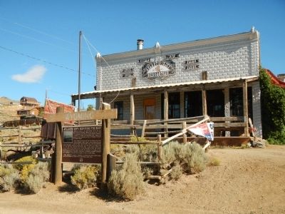
As the news of gold spread, the Sweetwater Mining District filled with miners who established Hamilton City about two miles east of here in 1867. The following year, the name of the town changed to Miners Delight, after a highly productive nearby . . . — — Map (db m80133) HM
“The Sinks” are a series of cracks and crevices at the back of the cavern before you. The water of the Popo Agie River flows into the Sinks. It then reappears at the “Rise of the Sinks,” a large calm pool ¼ mile down canyon. . . . — — Map (db m95824) HM
Viewed from Beaver Rim, the Wind River Mountains, part of the Rocky Mountain chain, boast 53 granite peaks over 13,000 feet high. The Continental Divide runs the length of the Wind River Range. Water on the east side of the Continental Divide flows . . . — — Map (db m67012) HM
This schoolhouse was built by John Borner along the Old Indian Trail near the mouth of Sinks Canyon. Mr. Borner was well known by residents of Lander for is large, plentiful garden. He was married in 1875 to Lena (Jenny) Canary, the sister of the . . . — — Map (db m95865) HM
This unique ornate building has been on Lander's Main Street since 1893. Built by Thomas J. Bossert and it was used for his dry goods store. He ran it as a "cash only" store. He advertised clothing at lower prices than every offered in Lander. He . . . — — Map (db m95870) HM
The Fremont served guests for eighty years on the corner of Main and 3rd, from 1891 to 1971. Jerry Sheehan had the foresight to build an out-of-the ordinary hotel in an isolated western town. Mr. Sheehan was no stranger to the hotel business. Prior . . . — — Map (db m95872) HM
The Historic Mine Trail and Byway Program designated the Gold Flakes to Yellowstone Historic Mine Trail in 2005. This trail links significant finds of gold, iron ore, and uranium, each of which played important roles in Wyoming's history.
The . . . — — Map (db m67011) HM
The Historic Mine Trail and Byway Program designated the Gold Flakes to Yellowstone Historic Mine Trail in 2005. This trail links significant finds of gold, iron ore, and uranium, each of which played important roles in Wyoming's history.
The . . . — — Map (db m67015) HM
This building located at 202 Main Street in Lander, WY has weathered over a century of storied & varied history. The building before you was commissioned by, & constructed for, the local International Order of Odd Fellows in 1886. Initially the Odd . . . — — Map (db m131600) HM
In 1886, the social society, the International Order of Odd Fellows, funded the construction of this brick building. The Odd Fellows held their meeting upstairs which was reported as handsomely furnished, and was supplied with “electric . . . — — Map (db m95965) HM
The Lander Hotel was one of the first businesses on Lander’s dusty Main Street. It began as an eating place and stopover for bull-team freighters on their way to Fort Washakie. It was a one-story, four-room log building built by Ben Decora. Later . . . — — Map (db m95961) HM
Scouts and Trappers visited this area by 1811 and rendezvous were held in 1829, in 1830, and in 1836.
Camp Magraw, 1857, site 2.1 miles north.
Fort Thompson, 1857-1858, was located 4.4 miles north of here.
Camp Augur, 1869-1870, . . . — — Map (db m95785) HM
By 1887-88 the farmers were pushing for a local flour mill and went as far as putting up some of their own money to entice someone to take on the project. At that time, wheat was grown in abundance but little was sold except as chicken feed. J. D. . . . — — Map (db m95967) HM
Major Noyes Baldwin and his wife, Josephine Wright Baldwin, were some of the earliest settlers in the Lander Valley. Before establishing the dry good store in Lander, he had a trading post near Hudson, Wyoming, a log trading post on Baldwin Creek, . . . — — Map (db m95946) HM
J.K. Moore, post trader at Fort Washakie, built the large store shown in mid-photo in the early 1880s. It was later to be one of the most elaborate saloons in the entire west, fitted out with glassware and furniture cut in the shape of diamonds. . . . — — Map (db m95868) HM
The Noble Hotel has been a landmark in downtown Lander since it was built in 1918. The grand hotel was built to serve visitors from the East on their way to Yellowstone. Harold Del Monte bought the hotel in 1929 and set out to recreate the Noble as . . . — — Map (db m95947) HM
This building was the second home to the Noble and Lane Mercantile Business. The face of the mercantile building has changed. It was originally built by Worden P. Noble and Albert D. Lane in 1891. The stone building next to it is where their . . . — — Map (db m95944) HM
To the south stand the Oregon Buttes, a major trail landmark. The name is significant because the Buttes were roughly the beginning of the Oregon Territory and also helped keep emigrants encouraged, even though there were still hundreds of miles of . . . — — Map (db m80499) HM
In 1891, Eugene Amoretti, successful businessman and one of the “town fathers,” financed the construction of this building. It was the original home of the Palace Pharmacy. The building was large enough to house many different . . . — — Map (db m95970) HM
In 1919 the Sinks Canyon Hydro Electric Company built a power plant in the canyon to provide electricity for Lander. A dam was built upstream of the Sinks. The dam diverted part of the Popo Agie River into a pipeline which carried the water to the . . . — — Map (db m95820) HM
Red Canyon is cooperatively managed by the Wyoming Game and Fish Department, the State of Wyoming, the Bureau of Land Management and private landowners.
The spectacular orange and red sandstone formations you see here have been exposed through . . . — — Map (db m80132) HM
The Red Canyon Wildlife Habitat Management Area (WHMA) before you is a crucial part of the entire winter range complex along the Southern Wind River Mountains in the Lander Area. The 1785 acres of the Red Canyon WHMA were purchased in 1958 primarily . . . — — Map (db m96368) HM
In 1842, gold was first found in the Wind River Mountains of Wyoming by a fur trapper, Georgia Tom Mckeever of the American Fur Company. Mckeever passed before he could get his gold to an assayer, leaving location unknown. Given the hostile . . . — — Map (db m152989) HM
At 7000 feet above sea level, Rocky Ridge is the highest point on the Mormon and Oregon Trails. This elevation, lack of water, and rugged landscape presented a challenge to early pioneers. The trail over Rocky Ridge is approximately two miles long . . . — — Map (db m96621) HM
From the time the glaciers of the last Ice Age retreated about 16,000 years ago, people have journeyed into Sinks Canyon. The canyon is a natural pathway into and over the southern Wind River Mountains. For thousands of years people, and wildlife, . . . — — Map (db m95818) HM
The heavily timbered slope before you provides excellent habitat for many species of wildlife. Douglas Fir trees with Oregon Grape, Mountain Lover, Snowberry, Wild Rose and many other shrubs in the under story, cover the slope. Vegetation is thicker . . . — — Map (db m95825) HM
In 1856 the United States Congress appropriated money to build the central division of the Fort Kearney-South Pass-Honey Lake Wagon Road from Nebraska to California. W.M.F. Magraw was appointed superintendent by the Secretary of the Interior. He was . . . — — Map (db m96164) HM
The South Pass, in which you are now located, is perhaps the most significant transportation-gateway through the Rocky Mountains. Indians, mountain men, Oregon Trail emigrants, Pony Express riders, and miners all recognized the value of this . . . — — Map (db m67016) HM
From where you're standing South Pass doesn't look all that remarkable. But compared to the rugged Wind River Mountains, it can easily be recognized as a type of gateway.
Nevertheless, crossing the Continental Divide into "Oregon Country" was a . . . — — Map (db m67020) HM
Even after the discovery of South Pass in 1824, it was years before the route was used extensively. Fur trapper/trader William Sublette brought a small caravan of wagons to South Pass in 1828. While his party did not take wagons over the pass, they . . . — — Map (db m67021) HM
South Pass was discovered in 1812 by a small band of Astorians led by Robert Stuart as they traveled east with dispatches for John Jacob Astor. It was “rediscovered” in 1824 by a party led by Jedediah Smith as they searched for a winter . . . — — Map (db m80501) HM
The hills of the Sweetwater Mining District hold various minerals, and beginning in the 1960s, iron ore mining provided an economic boom for the area. In 1960 the U.S. Steel Corporation broke ground on the nation's highest open pit iron ore mine at . . . — — Map (db m67014) HM
The trail over South Pass is a transportation corridor which served many purposes. In addition to being the route to Oregon and California, it was used by Mormon pioneers and by the Pony Express.
A great exodus to the Salt Lake Valley in 1847 . . . — — Map (db m67019) HM
The demand for beaver pelts in the early 1800s led to the exploration and eventual settlement of the American West. South Pass was part of a major thoroughfare through the Rockies and its discovery is significant to the era known as the fur trade. . . . — — Map (db m67022) HM
The Oregon Trail
In memory of those who passed this way to win and hold the West
Plaque placed by the Historical Landmark Commission of Wyoming
1950 — — Map (db m80504) HM
The Rise of the Sinks is a large spring where the water of the middle fork of the Popo Agie River reappears after flowing into a limestone cavern called the Sinks, located a quarter of a mile upstream.
The water flows underground following an . . . — — Map (db m95819) HM
With South Pass behind them, Oregon and California-bound travelers faced the second half of their journey. The roughest travel was yet to come. From Missouri to South Pass, emigrants were able to follow rivers. But from South Pass to Oregon and . . . — — Map (db m67018) HM
The Twin Mounds are a minor landmark along the Trail. These low hills on either side of the Trail helped keep emigrants headed in the right direction on the final climb to South Pass.
After the wagons passed between the Mounds, they fanned out . . . — — Map (db m237435) HM
The James G. Willie Handcart Company was rescued on October 21, 1856 by a rescue party sent by Brigham Young. 21 members of the Willie Company perished in this valley due to a severe winter storm and lack of clothing and food. Captain Willie left in . . . — — Map (db m96622) HM
An arrastra is a type of primitive mill used to crush ore and extract gold and silver. Water diverted from Willow Creek turned the large water wheel to provide power. A drive shaft connected to the wheel rotated a series of cogwheels that in turn . . . — — Map (db m154156) HM
Two related, side-by-side markers pay tribute to Esther Hobart Morris.
Home & office site of
Esther Hobart Morris
First woman Justice
of the Peace
in the World
Feb. 14, 1870 . . . — — Map (db m80149) HM
1869 - 1925
Site of
First Masonic Lodge in Wyoming
No. 28
under jurisdiction of Nebraska
Now
Wyoming Lodge No. Two
Lander, Wyoming — — Map (db m80150) HM
As early as 300 BC, the Greeks use the primary components of a stamp mill - drive wheel, cams, and stamps - for pounding and hauling grain. The concept was adapted to crushing ore and became widely used in America as a gold recovery process.
. . . — — Map (db m154146) HM
In 1858, this ancient path, which had been used by Indians, explorers and mountain men as a short cut to the Snake River country was developed by Frederick Lander in to an alternate route on the Oregon Trail. What is commonly called the Lander Trail . . . — — Map (db m80161) HM
With spring, the meadow grasses and broad-leafed plants, called forbs, emerge green and succulent. Antelope, mule deer, and elk wintering south and west of here return each spring to the green grass and forb meadows found in the sagebrush desert and . . . — — Map (db m96700) HM
For many emigrants, the first tangible evidence that the had crossed South Pass was Pacific Springs, "the fountain source of the Pacific streams," according to pioneer Joseph Goldsborough Bruff. The broad expanse of the pass from Pacific Springs . . . — — Map (db m96660) HM
A region rich in history. A city rich in gold. From 1812 to 1868 this open country at the end of the Wind River Mountains provided a passage - the only passage - through the Rocky Mountain barrier of the Continental Divide for some 500,000 westering . . . — — Map (db m80160) HM
Founded 1868
A Great Gold Camp
Part of Wyoming’s historical heritage. Acquired for preservation May 18, 1966, with funds raised by Wyoming;s 75th Anniversary Commission Inc., its advisers, county committees and people of . . . — — Map (db m80162) HM
Emigrant travelers on their way west likely discovered small amounts of gold in the 1840’s, but it took until 1868 for the first mining claims to be staked. Word of the new gold rush spread and the summer of 1868 brought an influx of people from . . . — — Map (db m80148) HM
Thousands rushed to the South Pass area following the find of substantial gold deposits at the Carissa Mine in 1867. As the boom gained steam, the Carissa sat at the center of mining development, serving as the primary economic force for South Pass . . . — — Map (db m80146) HM
Captain James G. Willie’s Handcart Company of Mormon emigrants on the way to Utah, greatly exhausted by the deep snow of an early winter and suffering form lack of food and clothing, had assembled here for reorganization by relief parties from Utah, . . . — — Map (db m80154) HM
Oregon-Mormon Trail
and Sixth Crossing
of Sweetwater River
Willie Handcart Company rescue site, 21 October 1856 and burial site of John Winford and eight others from that company
John Linford
Born 28 August 1808 England
Died . . . — — Map (db m95742) HM
The modern burg of Sweetwater Station is at the intersection of U.S. Highway 287 and State Route 135 in central Wyoming along the Sweetwater River. It is a place of scenic beauty and historic significance. Prehistoric groups camped along the . . . — — Map (db m95745) HM
In summer, the trilling “Kroo-oo-oo” of the sandhill crane is heard along the Sweetwater River. The endangered whooping crane has been seen in the marshy meadows immediately south of this spot. The Sweetwater’s wide floodplain, enhanced . . . — — Map (db m95747) HM
The Sweetwater Valley is the mid-section of the 2000 mile-long Oregon Trail. West of Casper, Wyoming, branches of that trail, meld into a single transportation corridor and here, paralleling the serpentine Sweetwater River, the trail approaches the . . . — — Map (db m95776) HM
Late in the year of 1856, the Willie and Martin Handcart Companies and the Hunt and Hodgetts Wagon Companies left Iowa City for their journey westward. Near this spot, these companies crossed the Sweetwater River for the sixth time, thus the name . . . — — Map (db m95743) HM
This marks a fork in the trail, right to Oregon, left to Utah and California.
1812, Robert Stuart and eastbound Astorians used South Pass gateway.
1824, Eleven westbound Ashley-Henry men led by Jedediah Smith and Thomas Fitzpatrick.
. . . — — Map (db m67035) HM
Trail ruts at this site were mistakenly identified as the Parting-of-the-Ways where emigrant parties separated on their journeys to Oregon, California, or Utah.
The actual Parting-of-the-Ways is approximately 10 miles west of this spot. . . . — — Map (db m237433) HM
In July 1844 the California bound Stevens-Townsend-Murphy wagon train, guided by Isaac Hitchcock and 81-year old Caleb Greenwood, passed this point and continued nine and one half miles southwest from here, to a place destined to become prominent . . . — — Map (db m67036) HM