Near 15th Street Northwest at F Street Northwest, on the right when traveling north.
Clara Barton lived a lifetime of tireless service to others. During the American Civil War, she became known as the “Angel of the Battlefield,” delivering supplies and caring for the sick and wounded. After the war, Barton organized a . . . — — Map (db m92177) HM
On 7th Street Northwest south of E Street Northwest, on the right when traveling north. Reported permanently removed.
“I have paid the rent of a room in Washington… retaining it merely as a shelter to which I might return, when my strength should fail me under exposure and labor at the field.”
Clara Barton, December . . . — — Map (db m36174) HM
On 7th Street Northwest just south of E Street Northwest, on the right when traveling north.
"I have paid the rent of a room in Washington… retaining it merely as a shelter to which I might return, when my strength should fail me under exposure and labor at the field."
Clara Barton, December 1863
On Bayshore Boulevard at South Plant Avenue, on the right when traveling south on Bayshore Boulevard.
Clarissa 'Clara' Harlowe Barton traveled through Tampa, in 1898, on her way to and from Cuba during the Spanish American War. Barton often stayed at the home of J. Mack Towne, which was located just north of this marker at 350 Plant Avenue. There . . . — — Map (db m156548) HM
On Prison Site Road at Cemetery Road, on the left when traveling south on Prison Site Road.
In Commemoration of the Untiring Devotion of Clara Barton ———— She organized and administered efficient measures for the relief of our soldiers in the field, and aided in the great work of preserving the names of more than . . . — — Map (db m12126) HM
On Broadway Street just east of North 2nd Street, on the right when traveling east.
The organizer of the American Red Cross in 1881, Clara Barton, came to Paducah March 13, 1884, on the steamboat "Josh V. Throop" to help direct relief work during the Ohio River flood. Relief boats traveled from Pittsburgh to Cairo in first flood . . . — — Map (db m158788) HM
Clara Barton House has been designated a Registered National Historic Landmark under the provisions of the Historic Sites Act of August 21, 1935. This site possesses exceptional value in commemorating and illustrating the history of the United . . . — — Map (db m70672) HM
On MacArthur Boulevard at Goldsboro Road (Maryland Route 614) on MacArthur Boulevard.
Early headquarters of the American Red Cross and home of Clara Barton, founder and First President, who lived here until her death in 1912. Located just south of this marker, the house had an unusual interior of Steamboat Gothic design with railed . . . — — Map (db m303) HM
Near Oxford Road west of MacArthur Boulevard, on the left when traveling south.
Did you know a heroine lived right here in Glen Echo, Maryland? Fearless, selfless. and determined, Clara Barton dedicated her life to helping others. Know as the “Angel of the Battlefield” during the Civil War and founder of the . . . — — Map (db m104015) HM
On Mansfield Avenue, on the left when traveling east.
During the Battle of Antietam September 17, 1862 Clara Barton brought supplies and nursing aid to the wounded on this battlefield. The act of love and mercy led to the birth of the present American National Red Cross
Additional . . . — — Map (db m141486) HM
On Mansfield Avenue, on the left when traveling east.
"I have been permitted to stand by your loved ones when the trial hour came..." For some, service to their country ended with the Civil War. For Clara Barton, this was the beginning. Barton, a forty year old teacher, patent clerk and . . . — — Map (db m20671) HM
On Main Street (Massachusetts Route 12) at Clara Barton Road, on the right when traveling south on Main Street.
One mile westward Clara Barton, "the angel of the battlefield," was born in 1821. A volunteer nurse in the Civil War, she served the International Red Cross in the Franco-Prussian War, founded the American Red Cross and served as its president for . . . — — Map (db m48042) HM
On Crosswicks Street at East Burlington Street, on the left when traveling west on Crosswicks Street.
Clara Barton, best known as a Civil War nurse and founder of the American Red Cross, was significant in New Jersey history for beginning the first "free" public school in the state. Barton took a teaching position in Hightstown in 1851, at the . . . — — Map (db m36470) HM
Near Clinton Street west of South Delaware Avenue, on the right when traveling west.
"I have an almost complete disregard of precedent, and a faith in the possibility of something better…I defy the tyranny of precedent. I go for anything new that might improve the past."
- Clara Barton
Born: . . . — — Map (db m220955) HM
On Elizabeth Street just north of Ossian Street, on the right when traveling south.
Given to Clara Barton, Chapter No. 1 of the American National Red Cross, in memory of Emma Hartman Noyes, a charter member of this chapter, by her children Nicholas H. Noyes, Jansen Noyes, and Katherine E. Noyes, December 28, 1949. — — Map (db m198737) HM
On Mount Hope Avenue (New York State Route 15) 0.1 miles south of Westfall Road, on the right when traveling north.
Clara Barton Red Cross Trail linking chapters 1 & 2 of the American Red Cross founded by Miss Barton at Dansville & Rochester 1881 — — Map (db m115302) HM
Near S. Main Street (U.S. 283) at S. 2nd Street, on the right when traveling north.
Scottish immigrant John Brown (1842-1903) moved west following his theological studies in New York. He married Mary Jane Matthews Larn near Fort Griffin and in 1884 became minister of Albany Presbyterian Church, just as West Texas farmers and . . . — — Map (db m85634) HM
On George Street at Princess Anne Street, on the right when traveling east on George Street.
Founder of the American Red Cross. A devoted nurse and tireless organizer who knew no enemy but the unfeeling heart. We walk the ways she took in easing the suffering at the Battle of Fredericksburg when the churches became military hospitals. — — Map (db m14428) HM
Clara Barton's property was a reflection of her personality: practical, thrifty, and just a bit eccentric. Visitors to her home frequently commented on the utilitarian grounds filled with fruit trees and rows of vegetables instead of formal gardens. . . . — — Map (db m103973) HM
Beyond the trees stands a Victorian House as unique as its owner. This house was built for Clara Barton in 1891 by Edward and Edwin Baltzley as part of the National Chautauqua at Glen Echo. With 30 rooms serving as offices, bedrooms, and storage, . . . — — Map (db m45000) HM
"You have never known me without work;
while able, you never will." —Clara Barton
Clara Barton lived a life that transcended limitations. She built a career of humanitarian service in a society that did not grant her full rights . . . — — Map (db m45245) HM
On Mansfield Avenue, on the left when traveling east.
At a farmhouse and barn not far from here, Clara Barton labored without sleep for three days, comforting the wounded of the Battle of Antietam with water, food, and medical supplies. Clara Barton, founder of the American Red Cross, began her . . . — — Map (db m5902) HM
On Main Street at Main Street, on the right when traveling north on Main Street.
Dorence Atwater grew up in the Terryville section of Plymouth. He enlisted in the union Army in 1861 and was captured by Confederate forces in 1863. In February 1864, he was moved to the infamous Andersonville prison camp in Georgia, . . . — — Map (db m28053) HM
Near Enon Church Road (Virginia Route 746) at Point of Rocks Road, on the left when traveling west.
Patients at Point of Rocks Hospital were under the care of two pioneer women in the field of medicine, Clara Barton and Harriet Dame. At a time when most women were not allowed to be near the fighting, these women saw the war close up at field . . . — — Map (db m109378) HM
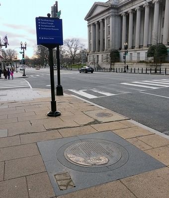
On 7th Street Northwest south of E Street Northwest, on the right.
Missing Soldiers.
Office, 3rd Floor, Room 9
Miss Clara Barton
Clara Barton is famous for her fierce determination and courage to save lives on the Civil War battlefields, and later for founding the American Red Cross.
1861-1865: . . . — — Map (db m36172) HM
Near Clara Barton Parkway, 1.5 miles Capital Beltway Inner Loop (Interstate 495), on the right when traveling east.
After being neglected for nearly a decade, the Chesapeake and Ohio Canal received new life with the New Deal programs in the late 1930s. Two African American Civilian Conservation Corps camps were setup at nearby Cabin John and Carderock to . . . — — Map (db m105328) HM
Near Halsema Road North, 0.4 miles Old Plank Road, on the right when traveling north.
The Confederate prison at Andersonville, Georgia was one of the most notorious military prisons in American history. Following the Civil War and under the direction of Congressman William Seward; Clara Barton and Dorrance Atwater, a former . . . — — Map (db m142654) HM
On South West Shore Boulevard at Interbay Boulevard, on the right when traveling north on South West Shore Boulevard.
From April to June, 1898, Tampa served as port of embarkation for U.S. troops on their way to Cuba. Some 30,000 troops arrived in Tampa and 16,000 embarked from Port Tampa on June 7. The Tampa Bay Hotel was headquarters for the force's leaders . . . — — Map (db m13635) HM
On West Kennedy Boulevard near University Drive, on the right when traveling west.
Henry B. Plant built this ornate Moorish structure at a cost of $3 million. Opened in 1891, it became the social and cultural center of early Tampa. During the Spanish American War it was headquarters for troops going to Cuba and housed such . . . — — Map (db m20020) HM
On Locust Street north of West 7th Street, on the right when traveling north.
This imposing Victorian structure built circa 1860 by Dr. William Doswell Stirman, a successful physician. Received its name because he spent a fortune building it. In 1915, Samuel R. Ewing, civic leader and tobacco farmer, purchased and remodeled . . . — — Map (db m160124) HM
On Elm Street at North 2nd Street, on the right when traveling east on Elm Street.
This Federal style house was built by the town's founder, James Young, in 1797. Clara Barton, founder of the American Red Cross, stayed here while distributing flood relief to the victims of the 1884 flood. — — Map (db m122119) HM
Near Macarthur Boulevard south of Goldsboro Road, on the right when traveling south.
Fun is where you find it...
Glen Echo Park, the Washington DC Metro area's premier amusement park from 1898 to 1968, is the only amusement park preserved by the National Park system. In the early 1890's this was a National Chautauqua . . . — — Map (db m130060) HM
On Johns Street at Walnut Street, on the right when traveling south on Johns Street.
On June 5, 1889, Clara Barton and a group of American Red Cross volunteers arrived in Johnstown to help the survivors of a devastating flood resulting from the failure of the South Fork Dam. It was one of the first major disaster responses for the . . . — — Map (db m74402) HM
On Ox Road (Virginia Route 123) at Fairfax Station Road, on the right when traveling south on Ox Road.
Here at Fairfax Station in early Sept. 1862, after the Second Battle of Manassas and the action near Chantilly, Clara Barton ministered to the suffering. By her humane and tireless efforts this Angel of the Battlefield helped move over 3000 wounded . . . — — Map (db m102) HM
On Cool Springs Road (County Route 607) 0.3 miles south of White Oak Road (Virginia Route 218), on the left when traveling south.
During the Civil War, a railroad station stood on this site. The station consisted of a warehouse, a platform, quartermaster tents, and several sidings. Trains arrived and departed on the hour traveling to and from Aquia Landing. The station . . . — — Map (db m75944) HM
Near Clara Barton Parkway south of the Glen Echo Exit. Reported permanently removed.
“When I was 7, we moved [to the] lock, and we were very happy. My mother was so happy to have a home; she was just about wild. And we did love it here, as a locktender, you know?” —Lavenia Cross Waskey
On Cemetery Road, 0.4 miles north of Prison Site Road, on the right when traveling north.
The prisoners' headstones are only inches apart. As the death rate at Andersonville escalated to 100 per day, officials abandoned the use of pine-box coffins and had the bodies buried shoulder to shoulder in trenches. At first only numbered stakes . . . — — Map (db m173069) HM
Near Darnestown Road (Maryland Route 28) east of Seneca Road (Maryland Route 112), on the left when traveling east.
Soldiers feared bullets and bayonets on the battlfield, but the greater danger was the invisible presence of bacteria in both Union and Confederate camps. By 1865, 620,000 men were casualties of war; the bulk succumbed to communicable diseases like . . . — — Map (db m69818) HM
On South Opera Street at East Columbus Avenue, on the left when traveling south on South Opera Street.
Born in Mt. Pleasant, Ohio, William Lawrence moved to Bellefontaine shortly after graduating from Cincinnati Law School in 1840. Lawrence was prosecuting attorney for Logan County (1845); a member of the Ohio Legislature (1846, 1847, 1849-51, . . . — — Map (db m22049) HM
Near Fairfax Station Road west of Ox Road (Virginia Route 123), on the left when traveling west.
Dedicated September 19, 1858 by Rt. Rev. John McGill, Bishop of Richmond. — Catholic workers, who were employed in building the Fairfax Railroad pass, began work on the structure in 1856. They were assisted by members of the nearby Hamill . . . — — Map (db m184) HM
On Kings Highway at Naomi Road, on the right when traveling east on Kings Highway.
Chatham, a Georgian manor house, was completed in 1771 for planter William Fitzhugh and his wife, Ann Randolph. George Washington and Thomas Jefferson were visitors here. Many enslaved African Americans worked on the plantation, and in Jan. 1805 a . . . — — Map (db m171422) HM
Ambrose E. Burnside's Union army had found existing bridges destroyed, and now R. E. Lee's Confederates awaited attack on high ground beyond Fredericksburg. On December 11, 1862, the Union engineers shivered in the early morning as they broke a skim . . . — — Map (db m4723) HM
On MacArthur Boulevard, on the right when traveling east.
Guests at the Bobinger brothers’ Cabin John Hotel entered the grounds by way of an ornate iron foot bridge crossing Cabin John Creek and ascended along manicured paths to the garden entrance shown here. The place was extravagant in every way, . . . — — Map (db m164232) HM
On Seawall Boulivard, 0.2 miles east of Fort Crockeett Boulevard, on the right when traveling east.
Within days of the devastating storm of 1900 Clara Barton, founder of the American Red Cross, arrived in Galveston with personnel, supplies, and relief funds. Assisting the relief effort, which included Galveston Island and several mainland . . . — — Map (db m153172) HM
Chatham has watched quietly over Fredericksburg for almost 250 years—an imposing, 180-foot-long brick manor house once visible from much of town. It has witnessed great events and played host to important people. George Washington, Thomas . . . — — Map (db m35385) HM
Near Cummings Street (Alternate U.S. 58) at Mont Calm, on the left when traveling north.
Since 1776 more than 2½ million women have served in our military services in the defense of our nation. Beginning with the American Revolutionary War and continuing through the present day, in all military conflicts, including War of 1812, Civil . . . — — Map (db m210300) HM
If you were in this spot in 1891, you would have seen a two-story building nestled in trees overlooking the Potomac River and Chesapeake and Ohio Canal. The Hall of Philosophy was part of the National Chautauqua Assembly at Glen Echo, which offered . . . — — Map (db m104011) HM
Near Fort Street at Westport Street, on the right when traveling west.
Their names may not be recorded in the official records, but thousands of women volunteered their time, labor and money during the Civil War. As a teenager, Julia Gill, a future resident of Cape Girardeau, volunteered her services as a nurse, . . . — — Map (db m236815) HM
On Broadway Street east of South Water Street, on the right when traveling east.
(front:)
Here the Tenn. River flows into the Ohio. Owen's Island opposite Kentucky Ave. There in 1779 George Rogers Clark's small army landed to prepare for its defeat of the British in the Illinois country. In 1780 Col. John Donelson . . . — — Map (db m154667) HM
On Hannah Avenue just west of Woodmere Avenue, on the left when traveling west.
Early Romans named the dazzling white planet Venus, after their goddess of love and beauty. Venus is sometimes called Earth's sister planet because both are about the same size, composition and age. But conditions on the two planets are very . . . — — Map (db m213237) HM
On County Road 662 at Farnsworth Avenue, on the left when traveling east on County Road 662.
Though never larger than a small village, a remarkable cross section of notable and influential people lived in Bordentown in the eighteenth and nineteenth centuries.
Leaders of the American Revolution who lived on Farnsworth Avenue included . . . — — Map (db m160154) HM
Inman Avenue, the main thoroughfare of Colonia, was named for the painter Henry Inman (1801-46), the leading American portraitist of his time. Born in Utica, New York, Inman excelled in portrait painting and created lasting works of President . . . — — Map (db m126630) HM
Near State Road 2408 east of 133, on the right when traveling east.
The Hulltown Church of Christ organized shortly after the establishment of the village of Hulltown (later Moran) in 1883. In the early years, the congregation met in different homes. In 1886, real estate investor, Bem Scott, deeded Block 30, Lots . . . — — Map (db m144892) HM
On Princess Anne Street at George Street, on the left when traveling south on Princess Anne Street. Reported permanently removed.
Wounded Union Soldiers in a Fredericksburg yard, May 1864. All but one of these men have been wounded in the leg. Most of the wounded soldiers brought to Fredericksburg survived…
…But some did not. Hundreds of men died in the hospitals here . . . — — Map (db m2575) HM
Near Prince William Street, 0.1 miles west of Wellington Road, on the left when traveling west. Reported permanently removed.
Welcome to Manassas Industrial School/Jennie Dean Memorial, part of The Manassas Museum System. This Memorial tells the story of an institution of learning that was unique in Northern Virginia and of the visionary African-American woman who . . . — — Map (db m143085) HM
Near D Street Northwest east of 18th Street Northwest, on the right when traveling west.
Generations of Americans have given themselves to help others at home and around the world through the American Red Cross, generously donating time, money and blood. They have helped feed, shelter, and clothe those in need—from thousands of . . . — — Map (db m131073) HM
On New York State Route 28, 4.6 miles east of New York State Route 8, on the right when traveling east.
Childhood Home Near this Site
Matthew Brady was born of Irish immigrant parents and grew up here in Johnsburg off what is today called Pasco Road. Some records suggest that he was actually born here. Youngest of three children, his father was . . . — — Map (db m137822) HM
Near Enon Church Road (Virginia Route 746) at Ramblewood Drive, on the left when traveling west.
Point of Rocks, named for a sandstone cliff on the Appomattox River, marked the southern end of the Union defensive line that stretched across the Bermuda Hundred peninsula. In May 1864, the Union army seized property east of the present-day park . . . — — Map (db m54255) HM
Near Princess Anne Street (Business U.S. 17) at George Street, on the left when traveling south.
During the December 13, 1862 battle, thousands of wounded Union soldiers were crowded into Fredericksburg's houses and churches, including the Presbyterian Church across the street from you. During that period, Clara Barton, the future founder of . . . — — Map (db m148062) HM
On Prison Site Road south of Cemetery Road, on the right when traveling east.
This tablet is erected in commemoration
of the patriotic work of the Women's Relief Corps, auxiliary to the Grand Army of the Republic, in the preservation and improvement of this historic site, comprising 87 acres, of which 72.5 acres were . . . — — Map (db m48152) HM
On Depot Street west of North Bridge Street, on the right when traveling west.
In memory of the boys of 1861-1865 who offered their services for the integrity and unity of our Grand Republic during the War of the Rebellion
Dan S. Root Post 126
Department of Michigan
Grand Army of the Republic
Organized April . . . — — Map (db m216677) WM
On West Park Street, 0.2 miles west of Prince Street, on the left when traveling west.
The 330-mile Delaware River is the longest free-flowing river east of the Mississippi River is the longest free-flowing river east of the Mississippi River. Its watershed drains an area of 14,119 square miles in four states. This nationally . . . — — Map (db m160163) HM
Near Enon Church Road (Virginia Route 746) at Point of Rocks Road, on the left when traveling west.
Point of Rocks takes its name from a 60-foot high sandstone cliff located here along the Appomattox River. The site was used by Native Americans as a camp and observation point, and was mentioned by Captain John Smith in his notes on Virginia. A . . . — — Map (db m109399) HM
Near Lt Billy Webb Avenue, 0.1 miles north of Cook Street.
The American Civil War (1861-1865) was the result of decades of tension between the North and the South. Chief among the issues were expansion of slavery into the western territories, the South's declining political power, states' rights, and the . . . — — Map (db m210072) HM
On Riverfront Drive just south of Walnut Street, on the right when traveling north.
Ned Buntline. Pen name of Edward Z. C. Judson,
father of the dime novel, came to
Smithland to publish his works;
lived here in 1845. He brought
fame to “Buffalo Bill” (William Cody)
thru stories and promotion
of his renowned . . . — — Map (db m170134) HM
On Mechanic Street east of 24th Street, on the right when traveling west.
The present Tremont House is the third Galveston hotel to bear the name. The island's first Tremont House was built by the firm of McKinney and Williams in 1839 on the southwest corner of Postoffice and Tremont Streets.
An impressive two-story . . . — — Map (db m117389) HM
On Fairfax Station Road, 0.4 miles west of Ox Road (Virginia Route 123), on the right when traveling west.
The first Fairfax Station depot, built by Irish immigrants in 1852, was a stop on the Orange
and Alexandria Railroad from Alexandria to Gordonsville. Early in 1862, after Confederate forces withdrew, the railroad carried military supplies
and . . . — — Map (db m885) HM
Near Roosevelt Boulevard (Pennsylvania Route 56) at Lincoln Street, on the right when traveling south.
In 1889 Johnstown was a steel company town of Germans and Welsh. With a population of 30,000, it was a growing and industrious community known for the quality of its steel. Founded in 1794, Johnstown prospered with the building of the Pennsylvania . . . — — Map (db m203932) HM
On Memorial Avenue west of Virginia Route 110, in the median.
[Quotes are etched in glass on the top of the memorial:]
I'm still so very proud
of my Naval service.
I would do it again if I could.
Mildred Pearl Lane, Yeoman 2nd Class, US Navy, World War I
This award doesn't
have . . . — — Map (db m137193) WM
On Ellsworth Drive at Fenton Street, on the right when traveling north on Ellsworth Drive.
"… We take increased devotion to that cause
for which they gave the last full measure of devotion …
that this nation, under God, shall have a new birth of freedom …"
Abraham Lincoln
Gettysburg . . . — — Map (db m113541) WM
Erected by the State of Ohio to the honor and memory of the Ohio veterans of the Spanish-American War, Philippine Insurrection and the China Relief Expedition.
1898 — 1920
“The cause which triumphed through their valor will . . . — — Map (db m9868) HM
On S Main Ave, 0.1 miles north of 2nd St SW, on the right when traveling north.
Lest We Forget
U.S. and Sioux Center timeline:
1775---
Battle of Lexington
Battle of Concord
2nd Continental Congress formed
Battle of Bunker Hill
Olive Branch Petition issued
USS independence commissioned
Military . . . — — Map (db m118957) HM WM
* Inflectional forms of words are their plurals, singulars, and possessives as well as gramatical tenses and similar variations.