By Tim & Renda Carr, September 5, 2010
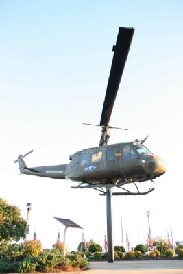
Bell UH-1 Iroquois (Huey) and Marker
| On McFarland Boulevard East (U.S. 82), on the right when traveling north. |
| On McFarland Boulevard East (U.S. 82), on the right when traveling north. |
| On Capstone Drive at Colonial Drive, on the right when traveling west on Capstone Drive. |
| On McFarland Boulevard East (U.S. 82), on the right when traveling north. |
| On McFarland Boulevard East (U.S. 82), on the right when traveling north. |
| On McFarland Boulevard East, on the right when traveling north. |
| On McFarland Boulevard East, on the right when traveling north. |
| On Loop Road, 0.1 miles east of Patton Avenue/Woodland Road, on the right when traveling east. |
| On McFarland Boulevard East (U.S. 82), on the right when traveling north. |
| On McFarland Boulevard East (U.S. 82), on the right when traveling north. |
| On McFarland Boulevard East (U.S. 82), on the right when traveling north. |
| On Blake Drive, on the right when traveling north. |
| On Whittier Way at West Willoughby Avenue when traveling south on Whittier Way. |
| On Alaska Highway (at milepost 1,422) at Richardson Highway, on the left when traveling north on Alaska Highway. |
| On Richardson Highway (Alaska Route 4 at milepost 13.9). |
| Near Parking Lot BIA 100 MP 0 (Route 100 Connector Road) 0.8 miles east of Route 12 N (Arizona Highway 263). |
| On Arizona Route 90 at milepost 314, on the right when traveling south. |
| On Grierson Avenue north of Hungerford Avenue, on the right when traveling south. |
| Near Cushing Street east of Cibecue Street. |
| On Grierson Avenue at Boyd Avenue, on the right when traveling south on Grierson Avenue. |
| On Hatfield Street at Irwin Street, on the right when traveling south on Hatfield Street. |
| On Forest Service Road 100, on the right when traveling west. |
| On Inspiration Avenue at Sullivan Avenue, on the right when traveling south on Inspiration Avenue. |
| On Broadway Avenue (Arizona Route 72 at milepost 27) south of Main Street, on the right when traveling west. |
| On Broadway Avenue (Arizona Route 72 at milepost 27) south of Main Street, on the right when traveling west. |
| On Broadway Avenue (Arizona Route 72 at milepost 27) south of Main Street, on the right when traveling west. |
| On Broadway Avenue (Arizona Route 72 at milepost 27) south of Main Street, on the right when traveling west. |
| On Broadway Avenue (Arizona Route 72 at milepost 27) south of Main Street, on the right when traveling west. |
| On Broadway Avenue (Arizona Route 72 at milepost 27) south of Main Street, on the right when traveling west. |
| On Broadway Avenue (Arizona Route 72 at milepost 27) south of Main Street, on the right when traveling west. |
| On Broadway Avenue (Arizona Route 72 at milepost 27) south of Main Street, on the right when traveling west. |
| On Broad Street (Arizona Route 72 at milepost 27) south of Main Street, on the right when traveling west. |
| On Broadway Avenue (Arizona Route 72 at milepost 27) south of Main Street, on the right when traveling west. |
| On Broadway Avenue (Arizona Route 72 at milepost 27) south of Main Street, on the right when traveling west. |
| Near Hi Jolly Road, 0.2 miles north of Quartzsite Boulevard. |
| Near Cemetery Street (Business U.S. 10) 0.1 miles north of West Main Street (U.S. 95) when traveling north. |
| On Beeline Highway (Arizona Route 87) near North Fort McDowell Road, on the right when traveling north. |
| On N. Greenfield Road at E. McKellips Road, on the right when traveling north on N. Greenfield Road. |
| On Innovation Way West at East Williams Field Road, on the right when traveling north on Innovation Way West. |
| On North Gavilan Peak Parkway, 0.2 miles south of West Anthem Way, on the left when traveling south. |
| Near E. Pinnacle Peak Road at Cave Creek Road, on the left when traveling west. |
| Near E. Pinnacle Peak Road at Cave Creek Road, on the left when traveling west. |
| On E. Pinnacle Peak Road at Cave Creek Road, on the left when traveling west on E. Pinnacle Peak Road. |
| Near Andy Devine Road (Business Interstate 40) near Grandview Avenue. |
| On East 3rd Street at Transcon Lane, on the right when traveling west on East 3rd Street. |
| Near West Duval Mine Road. |
| Near North Church Avenue. |
| On North Main Avenue at West Washington Street, on the right when traveling north on North Main Avenue. |
| Near North Church Avenue at Washington Street. |
| On North Church Avenue at West Washington Street, on the right when traveling south on North Church Avenue. |
| On North Illinois Street at Arizona Boulevard, on the left when traveling north on North Illinois Street. |
| On Alden Road north of Upton Road, on the right when traveling east. |
| On Sacaton Road (Arizona Route 87) at Sacaton-Casa Blanca Road, on the right when traveling east on Sacaton Road. |
| On Sacaton Road (Arizona Route 87) at Sacaton-Casa Blanca Road on Sacaton Road. |
| On Arizona Route 82 at milepost 29.5, on the right when traveling west. |
| Near East Hollamon Street, 0.3 miles North Montezuma Well Road (Arizona Route 260). |
| Near East Holloman Street, 0.2 miles north of Arizona Route 260. |
| On Entrance to Bob Stump VA Medical Center, on the right. |
| Near East Gurley Street east of North Arizona Avenue. |
| On Ave 64E near Interstate 8, on the left when traveling south. |
| On East Imperial Dam Road, 0.5 miles west of U.S. 95, on the right when traveling east. |
| Near 6800 Southwest Minuteman Avenue, on the left when traveling north. |
| On Arkansas Route 72 at North Curtis Avenue, on the right when traveling west on State Route 72. |
| On East Main Street west of South Maxwell Street, on the right when traveling east. |
| On Public Square south of West Church Street, on the left when traveling south. |
| On Southwest Second Street at Chestnut Street, on the right when traveling south on Southwest Second Street. |
| On South Moose Street north of East Church Street, on the right when traveling north. |
| On S. Main Street at W. Washington Street, on the left when traveling north on S. Main Street. |
| On West Washington Avenue at South Main Street, on the left when traveling north on West Washington Avenue. |
| On S. Main Street at W. Washington St., on the left when traveling north on S. Main Street. |
| On Main Street at South 4th Street, on the left when traveling west on Main Street. |
| Near Main Street at South 4th Street. |
| On Main Street (Arkansas Route 59) west of North 11th Street, on the right when traveling west. |
| On Main Street (Arkansas Route 59) east of Cane Hill Street, on the right when traveling east. |
| On Court Street near Cypress Drive, on the right when traveling north. |
| On Locust Avenue at Main Street, on the left when traveling north on Locust Avenue. |
| On Locust St. at W. Second St., on the left when traveling north on Locust St.. |
| On Main Street at Front Street, on the left when traveling west on Main Street. |
| On Brandenberg Ln at Graceland, on the right when traveling east on Brandenberg Ln. |
| On Brandenberg Lane at Graceland Street, on the right when traveling east on Brandenberg Lane. |
| On Maple Street (State Highway 29) at East 3rd Street, on the left when traveling north on Maple Street. |
| On North Beacon Road, 0.1 miles north of Custom, on the left when traveling north. |
| On Ramp Road north of Douglas Road, on the left when traveling north. |
| On Ramp Road north of Douglas Road, on the left when traveling north. |
| On Ramp Road north of Douglas Road, on the left when traveling north. |
| On West Main Street (U.S. 412) at Northwest 4th Street (Business U.S. 67), on the left when traveling west on West Main Street. |
| On North 2nd Street, 0.1 miles north of Commerce St, on the right when traveling south. |
| On State Highway 14, 0.1 miles north of Potter, on the right when traveling north. |
| On State Highway 140 east of State Route 136, on the left when traveling east. |
| On Route 140 east of Arkansas Route 136, on the left when traveling east. |
| On East Fleeman Street (State Highway 18) at Baltimore Avenue, on the left when traveling east on East Fleeman Street. |
| On West Cypress Street, 0.2 miles east of North Main Street (U.S. 49), on the left when traveling east. |
| On Stone Street (State Highway 7) at Church Street, on the right when traveling north on Stone Street. |
| Near Pecan Street south of Perry Street, on the right when traveling south. |
| On North Main Street north of Court Street, on the right when traveling north. |
| On North Main Street at Court Street, on the right when traveling north on North Main Street. |
8519 entries matched your criteria. Entries 101 through 200 are listed above.
⊲ Previous 100 —
Next 100 ⊳