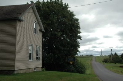
Home of Enoch Ambler
Inventor of First
Mowing Machine
Patent Signed by Pres.
Andrew Jackson in 1834
Heritage & Genealogical Soc. of Montg. Co
— — Map (db m68671) HM
Dedicated in our 70th year to commemorate the first official flag of the Incorporated Village of East Williston and to proclaim this bell as the village’s official emblem by the Board of Trustees on 13 October 1996
Mayor Dolores Sedacca • . . . — — Map (db m290679) HM
Water was pumped for the house by wind power. The windmill structure also offered a challenge to small gymnasts in the family who loved to clamber about it. — — Map (db m42976) HM
Pier A, a designated New York City landmark, was constructed by the Department of Docks' third Engineer-in-Chief, George S. Greene Jr. between 1884 and 1886.
The pier's two-story building served as the headquarters of the Department of Docks . . . — — Map (db m114673) HM
This line in the pavement represents the western edge of Manhattan in 1871. By that time, the shoreline had already been extended well to the west of the original location, which lay along present day Greenwich Street. The fill that expanded the . . . — — Map (db m154067) HM
This building, constructed in 1895, is among the best of the many eclectic firehouses built by Napoleon Le Brun & Sons. Today it seems surprising that such an elaborate design would be used for so utilitarian a structure. The entire spirit of the . . . — — Map (db m126953) HM
By 1796, a city engineer deemed Collect Pond to be stagnant and foul. A plan emerged to cleanse the pond and reconstruct it as a ship harbor with a channel to the Hudson River, but that plan was rejected. Instead, in 1803, the city decided to . . . — — Map (db m131783) HM
(Medallion)
The leveling of the hills • Fresh water pond filled 1802-1812
As early as 1780, draining the Collect Ponds was suggested to rid the area of pestilence thought to originate in this swampy land. The . . . — — Map (db m128686) HM
The long process of burying Collect Pond was completed by the mid-1810s, but its watery legacy remained. Streets laid over the former pond created a neighborhood that was briefly fashionable but quickly declined after the filled-in pond began to . . . — — Map (db m131785) HM
The Croton Fountain 1842-1870
This was the location of the Croton Fountain. It was fed by the Croton Aqueduct, which provided New York City with its first dependable supply of pure water. Considered one of the great engineering achievements of . . . — — Map (db m130147) HM
The American Immigrant Wall of Honor ® celebrates the peopling of America. The names of individuals and families are inscribed on the wall for posterity as gifts of remembrance through donations made to restore and maintain Ellis Island. The . . . — — Map (db m49817) HM
FishBridge Park is located on the south side of Dover Street, from Pearl to Water Streets. It is between the Fulton Fish Market, to the south, and the Brooklyn Bridge, to the north. Of the two distinguished New York institutions, Fulton Fish Market . . . — — Map (db m41322) HM
The design and layout of Governors Island National Historic District owes much of its development to changing times and roles. From early Dutch settlement to its incarnations as a military base to the US Army and the Coast Guard, Governors Island . . . — — Map (db m47183) HM
This dock is named in honor of the First United States Army soldiers who landed in Normandy during the invasion of France in World War II Dedicated by First United States Army 6 June 1964 — — Map (db m149153) HM
Above your head is nearly three million square feet of historic roofs. More than sixty percent of these roofs are covered in historic slate. In 2008, the Governors Island Preservation and Education Corporation (GIPEC) undertook the repair of these . . . — — Map (db m47205) HM
Yankee Pier is one of six docks and piers on Governors Island. It was built to hold large Coast Guard cutters. Cutters are vessels that are at least 65 feet long and can accommodate a crew living on board. The Y shape of the pier made it easier . . . — — Map (db m47202) HM
[ North Inscription ] To commemorate the one hundredth anniversary of the inauguration of George Washington as first President of the United States. [ South Inscription ] Let us raise a standard to which the wise and the honest can repair. . . . — — Map (db m41339) HM
Between 1886 and 1924, 14 million immigrants entered America through New York. The Statue of Liberty was a reassuring sign that they had arrived in the land of their dreams. To these anxious newcomers, the Statue’s uplifted torch did not suggest . . . — — Map (db m49321) HM
In 1883, a young writer, Emma Lazarus, donated a poem to an auction raising funds for the pedestal of the Statue of Liberty. “The New Colossus” vividly depicted the Statue of Liberty as offering refuge from the miseries of Europe. The sonnet . . . — — Map (db m49325) HM
The iron skeleton which supports the Statue was designed by this noted French engineer and bridge builder. He later designed and built the Eiffel Tower for the Paris World’s Fair of 1889. Dedicated by Mr. and Mrs. Marvin Kay Philip Rathner – . . . — — Map (db m49813) HM
The French sculptor, Frédéric Auguste Bartholdi designed the Statue of Liberty as a giant three-dimensional jigsaw puzzle. Over 300 thin sheets of copper, most of it from a copper mine in Karmoy, Norway, fit together to form the Statue’s outer . . . — — Map (db m49285) HM
He conceived this monument, showing the love of Liberty shared by France and America. This statue would be a gift from a people to a people. It was intended for the 1876 Centennial, but was delayed until 1886. De Laboulaye never saw his dream . . . — — Map (db m49811) HM
In 1883 this American poet and essayist wrote “The New Colossus” to aid the Pedestal Fund Campaign. Twenty years later her sonnet was cast in bronze and placed inside the Statue’s pedestal. “Give me your tired, your poor, . . . . . — — Map (db m49815) HM
A French sculptor and friend of De Laboulaye, he created the Statue of “Liberty Enlightening the World” and selected its site. Inspired by his first view of New York Harbor, Bartholdi later wrote “The Statue was born for this place which inspired . . . — — Map (db m49812) HM
As publisher of the New York World newspaper, this Hungarian immigrant conducted the editorial crusade that popularized the American Pedestal Fund Campaign. His last will and testament established the Pulitzer prizes for achievement in journalism, . . . — — Map (db m49814) HM
The Statue of Liberty conveys its message of freedom through a number of dramatic symbols. The broken shackles at her feet signify escape from tyranny. In her left arm, she holds a tablet of law inscribed in Roman numerals the date of the American . . . — — Map (db m49290) HM
Height from base to torch 151’ 1” (46.50m) Pedestal foundation to torch 305’ 1” (92.99m) Length of hand 16’ 5” (5.00m) Index finger 8’ 0” (2.44m) . . . — — Map (db m49332) HM
The Statue of Liberty was the first statue designed by Bartholdi to be completed. Earlier, in the 1850s, while traveling in Egypt, the Nubia and Ethiopia, he designed an immense lighthouse for the opening of the Suez Canal in Egypt, but the design . . . — — Map (db m49315) HM
The granite pedestal of the Statue was paid for entirely by private funds raised in the United States. It was designed by the eminent American architect, Richard Morris Hunt, and engineered by former Civil War General, Charles P. Stone. Its variety . . . — — Map (db m49287) HM
The answer is in the air. The Statue’s skin is made of copper, and when copper is exposed to oxygen in the air, it undergoes a chemical reaction called oxidation. The reaction causes a fine crust or film to develop that is usually green in . . . — — Map (db m49289) HM
This is the oldest synagogue building in continuous use in New York City. The congregation was established in 1839 and this temple, designed by Henry Fernbach, was completed in 1872. The style is Moorish Revival, the arrangement Gothic. . . . — — Map (db m147691) HM
The Hudson River was essential to the history and economic development of New York. The river provided food for early settlers and is still an important waterway for commerce, which led to the expansion and growth of the City. The recognized source . . . — — Map (db m41584) HM
Located at the base of the Niagara Escarpment, the ravine known as the Gully provided a naturally sheltered docking area where the Niagara River flows out of the steep and unnavigable Niagara Gorge. From this docking area, the Gully provided access . . . — — Map (db m94983) HM
Site of gates originally constructed in 1858 to control the inflow of water to the Hydraulic Tunnel and used for mechanical power by three manufacturing establishments. The tunnel was closed in 1954, the gate stems were dismantled, and concrete was . . . — — Map (db m105704) HM
This elevator was constructed by the commissioners of the State Reservation at Niagara Falls A.D. 1924 to replace the ancient Biddle Stairway. Alphonso T. Clearwater – Pres. Paul A. Schoellkopf • Ansley Wilcox Robert W. DeForest • Robert H. . . . — — Map (db m140066) HM
The wide point of the river at this spot is called the "Eddy Basin".
If you look over the edge you will see an extensive shelf of Whirlpool Sandstone at river level. This was covered by water prior to the large water diversions for . . . — — Map (db m74477) HM
Portage Road, constructed on an old Indian trail,
was used to transport goods around the falls from
the Lewiston Landing to Fort Schlosser on the
upper river. It held the key to governing the
entire Great Lakes area and the . . . — — Map (db m54345) HM
This C-47, also affectionately known as a "Gooney Bird", represents the History and Mission of the 914th Airlift Wing and the 328th Airlift Squadron. It is displayed in the markings of the 3rd Combat Cargo Squadron. The 3rd CCS pioneered Tactical . . . — — Map (db m75928) HM
Lake Island Park, established in the 1890's, was a popular tourist destination for those from Western New York, Rochester and the Toronto area. It originally consisted of a broad area around this site, including what is now the Tuscarora Yacht Club. . . . — — Map (db m74976) HM
First Light on the Great Lakes
You are standing near the site of the earliest lighthouse on the Great Lakes; a lantern room on the roof of the French Castle inside the fort. From that first whale oil fueled lantern, the Niagara . . . — — Map (db m67377) HM
Site of Lock 71, Summit Level; 710 feet above Rome; from here water flowed north to St Lawrence, south to Mohawk. State Education Department 1938 — — Map (db m137974) HM
First used as a school, later bought with large tract of land by John G. Post. Passed from family in 1905. Oneida County D.P.W. 1969 — — Map (db m137980) HM
Construction began in Rome N.Y. on July 4, 1817. The canal measured 40'x 28'x 4' and was 363 miles long. It went from Albany to Buffalo and was used into the 1830's. — — Map (db m54216) HM
Begun in the 1830's and enlarged to 70'x 56'x 7'. The improvement included double and larger locks and the capacity of handling more traffic. The enlargement was used until 1918 when the barge canal opened and horse-drawn boats became a thing of the . . . — — Map (db m54197) HM
Built 1842 By NY State. In use 1845 - 1918, replacing 1819 aqueduct located just downstream. One of 32 on the 19th century Erie Canal.
These limestone arches & piers held a wooden water-filled trunk 144 feet long and 49 feet wide, carrying . . . — — Map (db m24186) HM
The Old Erie Canal Historic Park is a 36-mile trail following the canal's towpath from DeWitt to Rome. This scenic trail passes through a variety of natural and cultural landscapes including open farmland, dense woods, and old canal communities. . . . — — Map (db m261003) HM
The Old Erie Canal State Historic Park is a 36-mile trail following the canal's towpath from DeWitt to Rome. This scenic trail passes through a variety of natural and cultural landscapes, including open farmland, dense woods, and old canal . . . — — Map (db m144324) HM
In 1820, the middle section of the Erie Canal was completed from Utica on the Mohawk River, to Montezuma on the Seneca River. Hugging the base of the Allegheny escarpment, the canal traversed thinly settled portions of Onondaga County, with . . . — — Map (db m261011) HM
Site of first religious society
of Borodino Church c. 1833
Spafford Town Hall 1870
Borodino Grange #1272 1912-1997
Spafford Area Historical Society 1997 — — Map (db m108495) HM
Buildings constructed on the banks of the canal had two distinct sides, one faced the canal and one faced the street.
The street sides of the buildings along the canal featured ornate facades to attract passing pedestrians and carriages. The . . . — — Map (db m144193) HM
You are standing across from the Weighlock Building on the towpath of the canal where the mule drivers and the mules that pulled canal boats once trod.
The Syracuse Weighlock Building, built in 1850 to weigh canal boats, is the last surviving . . . — — Map (db m138698) HM
The historic 60 foot wide right-of-way that became the Erie Canal in 1825 established N.Y.S. as the route to the west for an expanding nation. This corridor of commerce and culture, extending from Albany to Buffalo, made New York the Empire State. — — Map (db m138685) HM
The Erie Canal did much more than link the cities of Albany and Buffalo.
It opened America's midwestern heartland to European immigrants entering New York Harbor. The Weighlock Building, the only one remaining in the world, was built in 1850 . . . — — Map (db m144190) HM
That's the Weighlock Building across Erie Boulevard, where canal boats were weighed and tolls paid when this busy street was the Erie Canal. Cargo boats entered the stone lock chamber beneath the overhang, gates were closed at each end, the water . . . — — Map (db m138700) HM
The locks at the Weighlock are designed in the same manner as a standard lock. However, the basic function between a traditional lock and a weighlock differ. In a traditional lock, flooding the chamber was a simple function of gravity. The locks . . . — — Map (db m144191) HM
Pitts Park is located next to the Syracuse Weighlock Building, on the site of a former widewaters where boat captains would wait their turn to enter the weighlock. At your left, where Oswego and Erie Boulevards intersect today, was the confluence of . . . — — Map (db m138699) HM
Washington Street Rails Laid 1837 Removed April 21, 1937 by Mayor Rolland B. Marvin First thru train operated over the 17,000,000 dollar elevated structure Sept. 24, 1936 Washington Street construction plan approved Mar. 15, 1937 and work started . . . — — Map (db m142300) HM
Several Syracuse banks sprouted here along the Erie Canal, each striving to benefit from the commerce of a fast growing city. When the first canal section opened here in 1820 the settlement had 60 people. By 1900 its population reached 108,000. . . . — — Map (db m138697) HM
A weighlock was used to weigh canalboats so that a tariff could be determined on the cargo. Each time a boat captain took on a new cargo, he was required to have the cargo weighed and pay a toll.
Boats were weighed once a year to determine the . . . — — Map (db m144192) HM
the head representing the Atlantic Ocean features Neptune's trident upholding a crescent shaped moon, indicative of the relationship between the moon and the tides. To one side is the compass chart and to the other is the compass box top . . . — — Map (db m110223) HM
the Boyne head features the date "1690" - the year of the Battle of the Boyne when the Catholic King James was defeated by King William (Billy) of Orange.
The river rises in County Westmeath, touches County Offaly, flows into County Meath . . . — — Map (db m110217) HM
The Coleman Family • The Leigh-Hayden Family
The O'Brien Family • Hon. Leo Hayes & Family
The Dorsey Family • The Gooley Family
Jerry Wilson • The Collins Family • Chris Witting
The Ken Davis Family • The Dennis Ryan Family
Mayor Thomas . . . — — Map (db m110366) HM
1788 Survey 4 towns, 3 counties meet near this site. Starting point for survey of Phelps & Gorham Purchase done by Co. Hugn Maxwell in 1788. — — Map (db m126144) HM
At this point in 1828, water from Seneca Lake was first released into the newly constructed Cayuga-Seneca Canal, forming a navigable link to the Erie Canal. The waterway enabled commerce to flow between Seneca and the Hudson River and soon became an . . . — — Map (db m60113) HM
The first railroad appeared in Geneva in 1841. By the 1870's, railroads ran in all directions from Geneva. Over the years, the rail system expanded to include industrial and passenger service. Today the rail system is still used to bring raw . . . — — Map (db m60123) HM
This full-size model stands upon the remains of a wooden house built by the Seneca in the 1670s or 1680s. The modern tubes have been erected over the location of postmolds discovered through archaeological excavation in 1984. The diameter of each . . . — — Map (db m126484) HM
West Bloomfield, New York
circa 1857 constructed by
Stephen H. Ainsworth with
assistance from Seth Green,
by cold water springs, used
for observation & study of Brook Trout. — — Map (db m281422) HM
The existence of the Firemen's Memorial Fountain in Thrall Park is due largely to the efforts of Mr. J. B. Wheeler. The fountain, with its seven foot statue of a uniformed fireman holding a baby in his arm, is symbolic of and dedicated to the . . . — — Map (db m118332) HM
Formerly a one-room schoolhouse, District #13, Town of Wallkill. Built in 1851 by stone mason Samuel Bull. For 96 yrs. grades 1-8 attended. Closed in 1947.
Memorialized 2000 – Town of Wallkill — — Map (db m136993) HM
Honoring the celebrated landscape
architect, associate of Frederick Law
Olmstead, who designed the cemetery
in 1861.
——————————————
Hillside Cemetery has . . . — — Map (db m118380) HM
Hillside Cemetery, 1861. Picturesque design by Calvert Vaux,
renowned Anglo-American architect, and co-designer of
Central Park in New York City. — — Map (db m50386) HM
In honor of A. J. Crane, first president Monroe Improvement Association, estab. 1921 to purchase and improve land around the Mill Pond as a public park. — — Map (db m23673) HM
The 1800’s saw this site occupied by a fulling mill. During the 1900’s a blacksmith shop operated by Mr. Gimpsey was here. Circa 1925 a two-story wood frame soda fountian stood here. in 1919 “The Monroe Diner” was opened. It was operated . . . — — Map (db m24259) HM
Freemasons met here from 1817-1826. Purchased by the Cornerstone Lodge #711 in 1998. The 1817 Lodge Room remains active as of 2013. — — Map (db m68711) HM
First races held here, 1908. Last race, 1927. Track record was set in 1913 by Directum 1:2:04 1/2. The grandstand was razed in 1964. — — Map (db m25105) HM
Montgomery Street Station, one of the world’s earliest central electric stations, began service here in 1884. Built by Thomas A. Edison. — — Map (db m34006) HM
The first 5 brick houses on the east side of the street were saved from demolition by Ellzabeth Lyon in 1974. Newburgh's neighborhood preservation began on thls street. — — Map (db m34054) HM
Black dirt formed 12,000 yrs. ago in a glacial lake. Hearty farmers drained the swamp by hand. Their work made “Pine Island” the top onion area for the past 50 years. — — Map (db m180802) HM
This Model 1999 [sic - it was No. 199 produced] 12pd. Napoleon Civil War era (1861-1865) cannon was built by Revere Copper Company and inspected by Thomas Jefferson Rodman (T.J.R.), the Ordinance [sic - Ordnance] Inspector. His initials are . . . — — Map (db m107173) HM
This monument was erected by
the patriotic generosity of
Diana Farnum
and was dedicated July 4th,
1886, to the memory of the
Men of Deerpark
who, by their services
and lives in the
Civil War of 1861-5,
aided in preserving the . . . — — Map (db m107224) WM
Built in 1854 and used by the railroad until ca. 1987 Restored to full operating condition in 1996 it is one of a few left in the nation — — Map (db m107247) HM
Built in 1892, enlarged in
1912, this building served
as the Delaware Division's
largest station until its
closing in the mid 1970's.
Dedicated July 4 1986 — — Map (db m107250) HM
Dedicated June 22, 1969 by the Polish American Veterans of Massachusetts Inc. This fountain was first built by Colonel (later Brigadier General) Thaddeus Kosciuszko in 1778 — — Map (db m52804) HM
This gate, and the cemetery gate further along Washington Road, were the main gates to West Point during the last half of the nineteenth century. These intricately detailed cast iron gates and posts are rare survivors of early exterior decorative . . . — — Map (db m22330) HM
presented to West Point and the Nation by the Class of June 1943 and friends September 1988 [ Lower Marker : ] ROE/Eliseco Inc., a Burns and Roe Company Construction Merritt-Meridian Construction Corporation George A. Logan & Sons . . . — — Map (db m47306) HM
3554 entries matched your criteria. Entries 401 through 500 are listed above. ⊲ Previous 100 — Next 100 ⊳