After filtering for Virginia, 991 entries match your criteria. Entries 101 through 200 are listed.⊲ Previous 100 — Next 100 ⊳
Waterways & Vessels Topic
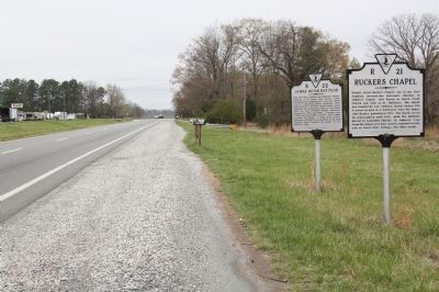
By J. J. Prats, April 9, 2011
James River Batteau and Rucker’s Chapel Markers
| 101 ► Virginia, Amherst County, Amherst — R-22 — James River Batteau — |
| On South Amherst Highway (Business U.S. 29) south of North Coolwell Road (County Route 663). | |||
| 102 ► Virginia, Amherst County, Amherst — The Amherst County Bateau / The Thornhill Wagon — |
| On South Main Street (Business U.S. 29) just north of Star Street, on the right when traveling south. | |||
| 103 ► Virginia, Amherst County, Monroe — A Lock Canal / A Lift Lock — |
| Near Blue Ridge Parkway (at milepost 63.6), 0.3 miles east of Lee Jackson Highway (U.S. 501), on the left when traveling south. | |||
| 104 ► Virginia, Amherst County, Monroe — Battery Creek Lock — 1851-1880 — |
| Near Blue Ridge Parkway (at milepost 63.6), 0.3 miles east of Lee Jackson Highway (U.S. 501), on the left when traveling south. | |||
| 105 ► Virginia, Amherst County, Monroe — Battery Creek Lock — As It May Have Looked in the Mid 1800's — |
| Near Blue Ridge Parkway (at milepost 63.6), 0.3 miles east of Lee Jackson Highway (U.S. 501), on the left when traveling south. | |||
| 106 ► Virginia, Amherst County, Monroe — The Lock Gate — |
| Near Blue Ridge Parkway (at milepost 63.6) near Lee Jackson Highway (U.S. 501), on the left when traveling south. | |||
| 107 ► Virginia, Amherst County, Monroe — Water Gap — |
| Near Blue Ridge Parkway (at milepost 63.6), on the left when traveling north. | |||
| 108 ► Virginia, Arlington County, Arlington, Arlington Forest — Mary Carlin House — |
| On North Carlin Springs Road. | |||
| 109 ► Virginia, Arlington County, Arlington, Arlington Mill — Flow Of Time — |
| On Columbia Pike (Virginia Route 244) just east of South Four Mile Run Drive. | |||
| 110 ► Virginia, Arlington County, Arlington, Arlington National Cemetery — A Symbol of Union — George Washington Memorial Parkway — National Park Service, U.S. Department of the Interior — |
| On Memorial Avenue, 0.1 miles east of Richmond Highway (Virginia Route 110), on the right when traveling west. | |||
| 111 ► Virginia, Arlington County, Arlington, Arlington National Cemetery — They Served with Honor - The Persian Gulf — 1990-1991 — |
| 112 ► Virginia, Arlington County, Arlington, Arlington National Cemetery — U.S. Coast Guard Memorial — |
| 113 ► Virginia, Arlington County, Arlington, Arlington National Cemetery — U.S.S. Houston and H.M.A.S. Perth — |
| On McClellan Drive east of Grant Drive, on the left when traveling west. | |||
| 114 ► Virginia, Arlington County, Arlington, Arlington National Cemetery — U.S.S. Salem — |
| On Grant Drive north of Bradley Drive, on the right when traveling north. | |||
| 115 ► Virginia, Arlington County, Arlington, Arlington National Cemetery — USS Frank E. Evans DD 754 — |
| On Grant Drive north of Porter Avenue, on the left when traveling north. | |||
| 116 ► Virginia, Arlington County, Arlington, Arlington National Cemetery — USS Serpens Memorial — |
| On Grant Drive at Bradley Drive, on the right when traveling north on Grant Drive. | |||
| 117 ► Virginia, Arlington County, Arlington, Ashton Heights — Maury School — |
| On Wilson Blvd. at N Monroe Street, on the right when traveling east on Wilson Blvd.. | |||
| 118 ► Virginia, Arlington County, Arlington, Bellevue Forest — Glenmore — |
| On Roberts Lane east of North Kenmore Street, on the left when traveling east. | |||
| 119 ► Virginia, Arlington County, Arlington, Crystal City — The March Across the Long Bridge — |
| On 6th Street South east of Long Bridge Drive, on the right when traveling east. | |||
| 120 ► Virginia, Arlington County, Arlington, Crystal City — Transportation — |
| On Eads Street at South Glebe Road (Virginia Route 120), on the right when traveling north on Eads Street. | |||
| 121 ► Virginia, Arlington County, Arlington, Fort Myer — Amphibious Scouts and Raiders World War II — 1942-1945 — "We led the way!" — |
| 122 ► Virginia, Arlington County, Arlington, Fort Myer — Evolving Vision — Arlington House, The Robert E. Lee Memorial — George Washington Memorial Parkway, National Park Service, U.S. Department of the Interior — |
| Near Sheridan Drive, 0.1 miles east of Humphreys Drive, on the right when traveling north. | |||
| 123 ► Virginia, Arlington County, Arlington, Fort Myer — Exercise Tiger Memorial — |
| 124 ► Virginia, Arlington County, Arlington, Fort Myer — Lancaster Monument — |
| On Capron Drive at McPherson Drive, on the right when traveling west on Capron Drive. | |||
| 125 ► Virginia, Arlington County, Arlington, Fort Myer — Mast of the USS Maine |
| Reported missing. | |||
| 126 ► Virginia, Arlington County, Arlington, Fort Myer — Naval Combat Demolition Units — |
| On Roosevelt Drive, on the right when traveling west. | |||
| 127 ► Virginia, Arlington County, Arlington, Fort Myer — Pearl Harbor Survivors Association — |
| Near Wilson Avenue east of Farragut Drive, on the right when traveling east. | |||
| 128 ► Virginia, Arlington County, Arlington, Fort Myer — Sailors, Coast Guardsmen and Marines of African and Asian-Pacific Descent — Cooks, Stewards, and Messmen — |
| 129 ► Virginia, Arlington County, Arlington, Fort Myer — Seafarers Memorial — |
| On Wilson Avenue west of Farragut Drive, on the left when traveling west. | |||
| 130 ► Virginia, Arlington County, Arlington, Fort Myer — U.S.S. Boston — ★ ★ ★ ★ ★ ★ ★ — |
| On Roosevelt Drive at Wilson Avenue, on the right when traveling east on Roosevelt Drive. | |||
| 131 ► Virginia, Arlington County, Arlington, Fort Myer — USS Underhill (DE-682) Memorial — |
| On Grant Drive just south of Roosevelt Drive, on the left when traveling south. | |||
| 132 ► Virginia, Arlington County, Arlington, Gravelly Point Park — A Roadside Respite — George Washington Memorial Parkway | Roaches Run Waterfowl Sanctuary — National Park Service, U.S. Department of the Interior — |
| On George Washington Memorial Parkway, 1.5 miles south of 14th Street Bridge (Interstate 395), on the right when traveling south. | |||
| 133 ► Virginia, Arlington County, Arlington, Green Valley — Jennie Dean Park — |
| On South Four Mile Run Drive just east of South Nelson Street, on the left when traveling west. | |||
| 134 ► Virginia, Arlington County, Arlington, High View Park — Hall's Hill Wall — |
| On 17th Road North west of North Culpeper Street, on the left when traveling west. | |||
| 135 ► Virginia, Arlington County, Arlington, North Highland — The Tulip Poplar - Giant of the Arlington Forest — |
| Near Palisades Trail, 0.1 miles west of 22nd Court North, on the left when traveling west. | |||
| 136 ► Virginia, Arlington County, Arlington, Potomac Overlook Regional Park — The Indian Spring — |
| Near Marcey Road, 0.2 miles north of Overlook Trail, on the right when traveling north. | |||
| 137 ► Virginia, Arlington County, Arlington, Potomac West — Four Mile Run and Flooding / The Restoration Project / I Live Here...Can You Find Me? / Public Art — |
| Near South Eads Street, 0.1 miles south of South Glebe Road (Virginia Route 120), on the right when traveling south. | |||
| 138 ► Virginia, Arlington County, Arlington, Woodmont — Fort C.F. Smith — Mr. Lincoln’s Forts — Defenses of Washington, 1861-1865 |
| Near 24th Street North. Reported permanently removed. | |||
| 139 ► Virginia, Arlington County, Arlington, Woodmont — Fort C.F. Smith — Mr. Lincoln's Forts — Defenses of Washington, 1863-1865 — |
| On 24th Street North, 0.1 miles west of 23rd Road North, on the right when traveling west. | |||
| 140 ► Virginia, Bath County, Warm Springs — Overshoot Wheel — |
| On Old Mill Road (Virginia Route 645) south of Old Germantown Road (Virginia Route 692), on the left when traveling south. | |||
| 141 ► Virginia, Bath County, Warm Springs — Waterwheel Restaurant Building — |
| On Old Mill Road (Virginia Route 645) just south of Old Germantown Road (Virginia Route 692), on the left when traveling south. | |||
| 142 ► Virginia, Bedford County, Bedford — 6th Engineer Special Brigade — National D-Day Memorial — |
| Near Overlord Circle, 0.4 miles west of Burks Hill Road. | |||
| 143 ► Virginia, Bedford County, Bedford — Abbott Lake — Stanley William Abbott — 1908 - 1975 — |
| Near Blue Ridge Parkway (at milepost 86), 0.4 miles north of Peaks Road (Route 43). | |||
| 144 ► Virginia, Bedford County, Bedford — Australia — National D-Day Memorial — |
| Near Overlord Circle, 0.4 miles west of Burks Hill Road. | |||
| 145 ► Virginia, Bedford County, Bedford — Belgium — National D-Day Memorial — |
| Near Overlord Circle, 0.4 miles west of Burks Hill Road. | |||
| 146 ► Virginia, Bedford County, Bedford — Bertram Home Ramsay — National D-Day Memorial — |
| Near Overlord Circle, 0.4 miles west of Burks Hill Road. | |||
| 147 ► Virginia, Bedford County, Bedford — Canada — National D-Day Memorial — |
| Near Overlord Circle, 0.4 miles west of Burks Hill Road. | |||
| 148 ► Virginia, Bedford County, Bedford — Exercise Tiger — 22-30 April 1944 — National D-Day Memorial — |
| Near Overlord Circle, 0.4 miles west of Burks Hill Road. | |||
| 149 ► Virginia, Bedford County, Bedford — Four Chaplains Field Chapel — National D-Day Memorial — |
| Near Overlord Circle, 0.4 miles west of Burks Hill Road. | |||
| 150 ► Virginia, Bedford County, Bedford — Fourth Infantry Division — “The Ivy Division” — National D-Day Memorial — |
| Near Overlord Circle, 0.4 miles west of Burks Hill Road. | |||
| 151 ► Virginia, Bedford County, Bedford — Greece — National D-Day Memorial — |
| Near Overlord Circle, 0.4 miles west of Burks Hill Road. | |||
| 152 ► Virginia, Bedford County, Bedford — Mulberry Harbors at Normandy — National D-Day Memorial — |
| Near Overlord Circle, 0.4 miles west of Burks Hill Road. | |||
| 153 ► Virginia, Bedford County, Bedford — Netherlands — National D-Day Memorial — |
| Near Overlord Circle, 0.4 miles west of Burks Hill Road. | |||
| 154 ► Virginia, Bedford County, Bedford — New Zealand — National D-Day Memorial — |
| Near Overlord Circle, 0.4 miles west of Burks Hill Road. | |||
| 155 ► Virginia, Bedford County, Bedford — Norway — National D-Day Memorial — |
| Near Overlord Circle, 0.4 miles west of Burks Hill Road. | |||
| 156 ► Virginia, Bedford County, Bedford — Poland — National D-Day Memorial — |
| Near Overlord Circle, 0.4 miles west of Burks Hill Road. | |||
| 157 ► Virginia, Bedford County, Bedford — Second Naval Beach Battalion — National D-Day Memorial — |
| Near Overlord Circle, 0.4 miles west of Burks Hill Road. | |||
| 158 ► Virginia, Bedford County, Bedford — Seventh Naval Beach Battalion — National D-Day Memorial — |
| Near Overlord Circle, 0.4 miles west of Burks Hill Road. | |||
| 159 ► Virginia, Bedford County, Bedford — Sixth Naval Beach Battalion — National D-Day Memorial — |
| On Overlord Circle, 0.4 miles west of Burks Hill Road. | |||
| 160 ► Virginia, Bedford County, Bedford — The United States — National D-Day Memorial — |
| Near Overlord Circle, 0.4 miles west of Burks Hill Road. | |||
| 161 ► Virginia, Bedford County, Bedford — U.S. Armed Guard and Merchant Marine — National D-Day Memorial — |
| Near Overlord Circle west of Burks Hill Road. | |||
| 162 ► Virginia, Bedford County, Bedford — U.S. Navy Women’s Reserve — Women Accepted for Volunteer Emergency Service “WAVES” — National D-Day Memorial — |
| Near Overlord Circle, 0.4 miles west of Burks Hill Road. | |||
| 163 ► Virginia, Bedford County, Bedford — United Kingdom — National D-Day Memorial — |
| Near Overlord Circle, 0.4 miles west of Burks Hill Road. | |||
| 164 ► Virginia, Bedford County, Bedford — United States Coast Guard — National D-Day Memorial — |
| Near Overlord Circle, 0.4 miles west of Burks Hill Road. | |||
| 165 ► Virginia, Bedford County, Bedford — United States Naval Academy — Ex Scientia Tridens — National D-Day Memorial — |
| Near Overlord Circle, 0.9 miles west of Burks Hill Road, in the median. | |||
| 166 ► Virginia, Bedford County, Bedford — USS Arkansas, BB-33 — Awarded Four Battle Stars for World War II Service — National D-Day Memorial — |
| Near Overlord Circle, 0.4 miles west of Burks Hill Road. | |||
| 167 ► Virginia, Bedford County, Bedford — USS Augusta, CA-31 — National D-Day Memorial — |
| Near Overlord Circle, 0.4 miles west of Burks Hill Road. | |||
| 168 ► Virginia, Bedford County, Bedford — USS LST-5 — Awarded Three Battle Stars for World War II Service — National D-Day Memorial — |
| Near Overlord Circle, 0.4 miles Burks Hill Road. | |||
| 169 ► Virginia, Bedford County, Bedford — USS Nevada, BB-36 — Awarded Seven Battle Stars for World War II Service — National D-Day Memorial — |
| Near Overlord Circle, 0.4 miles west of Burks Hill Road. | |||
| 170 ► Virginia, Bedford County, Bedford — USS Rich, DE-695 — Awarded One Battle Stars for World War II Service — National D-Day Memorial — |
| Near Overlord Circle, 0.4 miles west of Burks Hill Road. | |||
| 171 ► Virginia, Bedford County, Bedford — USS Texas, BB-35 — Awarded Five Battle Stars for World War II Service — National D-Day Memorial — |
| Near Overlord Circle, 0.4 miles Burks Hill Road. | |||
| 172 ► Virginia, Bedford County, Bedford — W.E. Steven’s Family Victory Garden — D-Day Memorial — |
| Near Overlord Circle, 0.4 miles west of Burks Hill Road. | |||
| 173 ► Virginia, Bedford County, Big Island — A Transportation Corridor — Navigating a Historic River — |
| Near Blue Ridge Parkway (at milepost 64), on the left when traveling south. | |||
| 174 ► Virginia, Bedford County, Big Island — James River — |
| Near Blue Ridge Parkway (at milepost 64), on the left when traveling south. | |||
| 175 ► Virginia, Bedford County, Huddleston — K-161 — Smith Mountain Lake — Bedford County — |
| On Interpretive Trail, 1.7 miles south of State Park Road, on the right. | |||
| 176 ► Virginia, Botetourt County, Buchanan — A 58 — Buchanan — |
| On Main Street (U.S. 11) south of Washington Street, on the right when traveling south. | |||
| 177 ► Virginia, Botetourt County, Buchanan — A-58 — Buchanan |
| On Main Street (U.S. 11), on the right when traveling south. Reported missing. | |||
| 178 ► Virginia, Botetourt County, Buchanan — Buchanan & The James River & Kanawha Canal — Celebrating more than two centuries of history — |
| Near Lowe Street (County Road T-1305) west of Main Street (U.S. 11), on the right when traveling west. | |||
| 179 ► Virginia, Botetourt County, Buchanan — A-91 — Looney's Ferry — |
| On Main Street (U.S. 11), on the right when traveling south. | |||
| 180 ► Virginia, Brunswick County, Alberta — S-60 — Sturgeon Creek — |
| On Boydton Plank Road (U.S. 1) 0.2 miles north of Poor House Road (County Route 642), on the right when traveling south. | |||
| 181 ► Virginia, Brunswick County, Broadnax — You are Traveling Through the Scenic Meherrin River Watershed! — |
| On Tobacco Heritage Trail, 0.8 miles east of Evans Creek Road (County Route 623), on the right when traveling east. | |||
| 182 ► Virginia, Buena Vista — L-11 — Moomaw’s Landing — |
| On West 29th Street (U.S. 60) west of Culvert Street (County Route 631), on the left when traveling west. | |||
| 183 ► Virginia, Caroline County, Port Royal — N-17 — Old Port Royal — |
| On King Street, 0.1 miles north of Cumberland Street, on the right when traveling north. | |||
| 184 ► Virginia, Caroline County, Port Royal — Port Royal Harbor — |
| On King Street, 0.1 miles north of Water Street, on the right when traveling north. | |||
| 185 ► Virginia, Caroline County, Port Royal — The Earliest Inhabitants: Native Americans — |
| On Water Street, on the left when traveling east. | |||
| 186 ► Virginia, Carroll County, Ivanhoe — Powering a Community — New River Trail State Park — |
| On Byllesby Road (County Route 602) at Buck Dam Road, on the left when traveling east on Byllesby Road. | |||
| 187 ► Virginia, Charles City County, Charles City — Chickahominy Water Trail — |
| Near Wilcox Neck Road (Virginia Route 623) 0.5 miles north of The Glebe Lane (Virginia Route 615). | |||
| 188 ► Virginia, Charles City County, Charles City — V-9 — Grant's Crossing — |
| On John Tyler Memorial Highway (Virginia Route 5) at Wilcox Wharf Road (Virginia Route 618), on the right when traveling east on John Tyler Memorial Highway. | |||
| 189 ► Virginia, Charles City County, Charles City — Herring Creek & Kimages — Charles City County, Virginia — |
| On John Tyler Memorial Highway (Virginia Route 5) at Kimages Road, on the right when traveling east on John Tyler Memorial Highway. | |||
| 190 ► Virginia, Charles City County, Charles City — Lane to Site of First Thanksgiving — |
| Near Harrison Landing Road, 0.7 miles south of Westover Road (Virginia Route 633), on the right when traveling south. | |||
| 191 ► Virginia, Charles City County, Charles City — Swineyards - Willcox Wharf — Charles City County, Virginia — |
| On John Tyler Memorial Highway (Virginia Route 5) at Wilcox Wharf Road (Virginia Route 618), on the right when traveling east on John Tyler Memorial Highway. | |||
| 192 ► Virginia, Charles City County, Charles City — 18 — Westover Plantation — Captain John Smith’s Adventures on the James — www.johnsmithtrail.org — |
| Near Westover Road (Virginia Route 633) 2.1 miles east of Harrison Landing Road. | |||
| 193 ► Virginia, Charlotte County, Charlotte Court House — FR-12 — Campaign of 1781 — |
| On David Bruce Avenue (Virginia Route 40) at County Road 9093 (County Route 9093), on the right when traveling east on David Bruce Avenue. | |||
| 194 ► Virginia, Charlotte County, Wylliesburg — F-82 — Staunton Bridge Action |
| On Barnesville Highway (U.S. 15) 0.2 miles north of Cannery Lane, on the left when traveling north. Reported damaged. | |||
| 195 ► Virginia, Chesapeake, Deep Creek North — Village of Deep Creek — "The den of the Rebels" — |
| On Luray Street, 0.3 miles north of George Washington Highway North (Business U.S. 17), on the right when traveling north. | |||
| 196 ► Virginia, Chesapeake, Greenbrier West — Bridging the Past with the Present — Great Bridge Battlefield & Waterways Park and Visitor Center — |
| Near Locks Road, 0.6 miles west of North Battlefield Boulevard (Virginia Route 168), on the left when traveling west. | |||
| 197 ► Virginia, Chesapeake, Greenbrier West — Civil War Anchor — The Waterways — |
| Near North Battlefield Boulevard (Business Virginia Route 168) at Locks Road, on the right when traveling south. | |||
| 198 ► Virginia, Chesapeake, Greenbrier West — Father & Son Canal Builders — The Waterways — |
| Near North Battlefield Boulevard (Business Virginia Route 168) at Locks Road, on the right when traveling south. | |||
| 199 ► Virginia, Chesapeake, Greenbrier West — Liquid Highways — The Waterways — |
| Near Locks Road, 0.6 miles west of North Battlefield Boulevard (Virginia Route 168), on the left when traveling west. | |||
| 200 ► Virginia, Chesapeake, Greenbrier West — Planning a Canal — |
| Near North Battlefield Boulevard (Business Virginia Route 168) at Watson Road, on the left when traveling south. | |||
991 entries matched your criteria. Entries 101 through 200 are listed above. ⊲ Previous 100 — Next 100 ⊳