On Salem Church Road (Pennsylvania Route 168) 0.1 miles south of Lisbon Road, on the right when traveling north.
October 25, 1796, Reverends John McMillan & Thomas Marquis dispensed northwest of Ohio River to found church. 1797 services first held in tent then in log church nearby. Erected in 1850, the present building is their first church. — — Map (db m50882) HM
On Midland Road (Pennsylvania Route 68/168) at Smiths Ferry Road, on the right when traveling east on Midland Road.
Oil boom town in 1860s-1870s. Oil shipped here on trains and river boats from wells in the Upper Dry Run and Island Run oilfields. Town had a hotel store post office and train station. All gone today. Rockport School remains. Neaby Glasgow had oil . . . — — Map (db m44179) HM
On Midland Road (Pennsylvania Route 68/168) 0.2 miles west of Calcutta Road, on the right when traveling east.
No survey of the western lands of the United States could be made as required under the land ordinance of 1785 until the surveyors for Pennsylvania and Virginia set a marker on the north shore of the Ohio River. On August 20, 1785, that marker was . . . — — Map (db m44181) HM
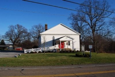
On Pennsylvania Route 68, 0.4 miles south of Benvenue Road, on the right when traveling north.
Benvenue Manor was built in 1816 by George Henry Mueller near the Old Venango Trail. Stone for the manor was quarried on the property. Saint Paul's Lutheran Church, Zelienople, was founded here. Also on the property is Sunrise Cottage, built in . . . — — Map (db m50287) HM
On Pittsburgh Road at Allendale Road, on the right when traveling north on Pittsburgh Road.
First Catholic cemetery in Beaver County. Land given by Edward Daugherty for Catholic burials upon the death of his brother 1801. Transferred to sponsor parish Saint Peter and Paul, Beaver 1832. Burial ground for parish priests, Father James Reid . . . — — Map (db m50285) HM
On Adams Street (Pennsylvania Route 68) at Harmony Avenue, on the right when traveling west on Adams Street.
Founded in Rochester by Henry Clay Fry President of the Rochester Tumbler and National Glass Company. Hundreds of skilled workers produced world renowned glass including cut, tableware, ovenware, art, industrial and optical glass of the finest . . . — — Map (db m45786) HM
Near Delaware Avenue, 0.1 miles north of West Madison Street (Pennsylvania Route 18).
Home of Joseph H. Bausman D.D. 1854-1924 author of best known and most used history of Beaver County 2-volume Published 1904
Pastor of United Presbyterian and congregational churches Rochester 1882-1907
Professor English Literature Washington . . . — — Map (db m50284) HM
On YMCA Drive, 0 miles east of Delaware Avenue (Pennsylvania Route 18/65), on the right when traveling west.
Built by Beaver Valley Traction Company to increase trolley ridership. 2 roller coasters, carousel, diner theatre, dance hall, dark ride, and grandstands with a racetrack and ballfields. In 1929 an Olympic pool was added. The rides were gone by 1941 . . . — — Map (db m51428) HM
On Water Street west of Harrison Street, on the right when traveling east.
In 1803, Meriwether Lewis led the corps of discovery, 11 men on a keelboat, though Beaver County. They stayed overnight about 3 miles west of Beaver and stopped in Georgetown. This visit was commemorated by a reenactment in Rochester and Georgetown . . . — — Map (db m44791) HM
On Water Street west of Harrison Street, on the right when traveling east.
Talgayeeta, a Cayuga Indian also known as Chief Logan lived here 1772. Logans sister Koonay married trader John Gibson here. Logans family was massacred by renegade whites at Yellow Creek in 1774. He then wreaked terrible vengeance on white settlers . . . — — Map (db m44880) HM
On Brighton Avenue, 0 miles north of Adams Street (Pennsylvania Route 68), on the right when traveling north.
Born in Rochester June 2, 1860 to Joseph R. and Matilda Cross Pendleton. United States Navy Academy 1878. He fired last shot in Spanish American War. Camp Pendleton California named in his honor. Died February 4, 1942. Buried at National Cemetery . . . — — Map (db m45789) HM
On Pine Run Road at Reno Road Extension/Grange Road, on the right when traveling east on Pine Run Road.
Oakland United Presbyterian Church was organized in 1870. A frame building was erected in 1872 on this site, donated by Thomas Boggs. Three pastors served the congregation: Reverend J.C. Evans, Reverend J. Patterson, and Reverend J.A. Hazlett. The . . . — — Map (db m51797) HM
Free and Accepted Masons of Pennsylvania, is the oldest Masonic Lodge in Beaver County. Meeting continuously since it was constituted April 11, 1848, a year before Rochester Borough was incorporated the Masonic Temple was built in 1884. — — Map (db m45785) HM
On Irvin Avenue at Clay Avenue, on the right when traveling north on Irvin Avenue.
Black residents of Rochester, some former Virginia slaves employed at Park Brick Works, organized the church in 1894 on Jefferson Street. The present church foundation was built in 1904 with bricks prepared by church men, women and children. — — Map (db m50184) HM
On Adams Street at Henon Avenue, on the right when traveling east on Adams Street.
The Camp House erected in 1870 by Michael Camp, Jr. Believed to be the oldest continuing family in Rochester. Leaders in civic, religious and fraternal affairs. This was home to three county commissioners and four masters of the Rochester Masonic . . . — — Map (db m50183) HM
On River Avenue at Bridge Street, on the left when traveling east on River Avenue.
West Aliquippa was boyhood home of composer Henry Mancini, who wrote scores for more than eighty movies, winning four Academy Awards and twenty Grammy awards. Born in Cleveland, Mancini lived at 401 Beaver Avenue and graduated from Aliquippa High . . . — — Map (db m48132) HM
On South Main Street south of Center Street, on the right when traveling south.
On this site in 1865-66 a tabernacle was erected by the pioneers. Built of local brick, lumber and stone. It was of pioneer architecture with a large assembly hall, gallery, full basement, a tower and large bell. This building was used for church . . . — — Map (db m75614) HM
For Honorable Judge Daniel Agnew, 1809-1902. Eminent jurist, author and respected citizen. Judge of the 17th District 1851 to 1863; then appointed to Pennsylvania Supreme Court, becoming Chief Justice in 1873. His home, where he resided over 60 . . . — — Map (db m40227) HM
On Water Street west of Harrison Street, on the left when traveling west.
The great Ohio River - and the Beaver River that flows into it - played important roles in attracting settlers to the Rochester area. Two hundred years ago, the rivers here served as main transportation routes, sources for industrial water power and . . . — — Map (db m55923) HM
On Water Street west of Harrison Street, on the left when traveling west.
In the 1880s, the heart of Rochester lay on the flat stretch of land along the Ohio River. The main road, Water Street, was a perfect location for businesses for many reasons. Proximity to the rivers and railroads meant heavy supplies could . . . — — Map (db m55906) HM
On Water Street west of Harrison Street, on the left when traveling north.
By 1851 the railroad had arrived at Rochester. Rail transit had been developed in the year before and had finally spread through Pittsburgh and surrounding western Pennsylvania towns.
Railroads were built on flat surfaces - one commonly flat . . . — — Map (db m55185) HM
On Water Street west of Harrison Street, on the left when traveling west.
Before bridges, ferry boats did a brisk business transporting passengers and their goods from shore to shore. But sometimes even ferries couldn't get through the area's frozen rivers in winter time.
It was in 1815 that the first bridge . . . — — Map (db m55159) HM
On East End Avenue just south of 3rd Street (Pennsylvania Route 68), on the right when traveling north.
Among the earliest settlers in the county were the slaves Fortune and Lunn, who were brought here by Levi Dungan around 1772. Many of the later African Americans who either eventually settled or passed through Beaver County came as they followed . . . — — Map (db m177037) HM
On East End Avenue, on the right when traveling north.
As county life attempted to return to normal following the end of WWII, the county was once again in an economic boom, and the
emphasis turned to recreation. This period saw the establishment of our county parks, a new county airport in Chippewa, . . . — — Map (db m177007) HM
On State Highway 23, 8 miles south of U.S. 412, on the left when traveling south.
You Are Now Entering Old
No Man's Land
Colorado Kansas 37th Parallel
Called "No Man's Land" until 1890
Known Then as
Beaver County
Became the Panhandle of Okla. Statehood 1907
Texas State Line 36° 30" Parallel
The . . . — — Map (db m93483) HM
On East End Avenue, on the right when traveling north.
Rivers:
1785/1964 - With the opening of the Indian lands on the north side of the Ohio River, ferries began operating
to carry settlers and goods across. Some of the earliest included: Chrisler's Ferry (Shippingport) and Thomas
Smith's . . . — — Map (db m177039) HM
On East End Avenue, on the right when traveling north.
Fall 1764 – British Colonel Henry Bouquet, then commander of Fort Pitt, led an army of 1,500 into
the Ohio country to help quell an Indian uprising known as "Pontiac's Rebellion.” The army encamped
along the Tuscarawas Trail near the present-day . . . — — Map (db m177030) HM
On Madison Street at Delaware Avenue, on the right when traveling east on Madison Street.
The Beaver Division of the Pennsylvania Canal System was one of the most important developments in early Beaver County history. This combination of a canal and slack water navigation system began at the mouth of the Beaver River and extended to . . . — — Map (db m206673) HM
On East End Avenue, on the right when traveling north.
The most important factor that drove the growth of industry in Beaver County was the dedication of
the workforce in producing the best quality product. These dedicated workers, led by men of great
vision and ambition, helped make American . . . — — Map (db m177025) HM
On East End Avenue, on the right when traveling north.
Patriotism has aiways been a Beaver County trait, and it was no different when the Civil War exploded on the scene. Eleven of the
270 regiments that the State of Pennsylvania raised contained one or more companies composed of Beaver County men, and . . . — — Map (db m176994) HM
On Evans City Road (Pennsylvania Route 68) 0.3 miles west of Raymond P. Shafer Highway (Interstate 79), on the right when traveling east.
Burial place of Harmonist Society, 1805-15. Graves were not marked. The stone wall was built in 1869, after the Harmonists had returned from Indiana and settled at "Old Economy," in Beaver County. — — Map (db m40434) HM
On Main Street at Mercer Street, on the right when traveling north on Main Street.
First home of Harmony Society, founded 1804, by George Rapp and German followers. In 1814 moved to New Harmony, Indiana, and settled at Economy in present Ambridge, Beaver County, in 1825. — — Map (db m40359) HM
On East End Avenue, on the right when traveling north.
1851 - Rail service came to Beaver County with the Ohio and Pennsylvania Railroad operating
along the north bank of the Ohio River.
1855 - The Stone family built the first of two houses on this site that were later acquired by the P&LE
for the . . . — — Map (db m176913) HM
On Madison Street at Delaware Avenue, on the right when traveling east on Madison Street.
One of the first river bridges constructed in Beaver County was the Big Beaver Tall Bridge, which connected the thriving manufacturing town of Bridgewater with its smaller suburb of "East” Bridgewater in 1815. This wooden, covered bridge lasted just . . . — — Map (db m206720) HM
On North Florence Street at 5th Street, on the left when traveling north on North Florence Street.
Organized Baptist work in the Oklahoma Panhandle began Aug. 5, 1894 when the Pleasant View Baptist Church was founded with 8 charter members 1½ mi. N and 1½ mi. E of here. Meetings were in the Pleasant View school house until after the . . . — — Map (db m55272) HM
Edward T. Guymon was born in Illinois in 1859. At 21 he moved to McPherson, Kansas from Coatsburg, Illinois. Story is he sold a cow for $22 to pay his fare west. He loaded coal for the Santa Fe Railroad as a clerk and partner for the Star . . . — — Map (db m55265) HM
Townsite planned on Rock Island Railroad survey by
Inter-State Land & Town Co. in 1900.
Rock Island Railroad built through Oklahoma Panhandle 1901.
Town founded as Sanford Post Office 14 June 1901, changed to
Guymon Post Office on 29 June . . . — — Map (db m55267) HM
On U.S. 54, 0.4 miles east of East Street, on the right when traveling east.
The post office of Loretta was established May 7, 1898. It was moved to the Texas-Okla. line and the name was changed to Texhoma on Nov. 12, 1901.
The Panhandle of Okla. was called No Man's Land. It was owned by Spain in 1541, . . . — — Map (db m78864) HM
On East End Avenue, on the right when traveling north.
Just after the turn of the century, large industries recognized the advantages of locating within the county, and began moving here. Some,
like the steel companies, chose plots of ground along the Ohio River and began building not only their . . . — — Map (db m177001) HM
On East End Avenue, on the right when traveling north.
Beaver County industry and life were booming as the country became involved in WWI. Once again, we were well represented as Beaver
Falls native Colonel Joseph H. Thompson was awarded the Medal of Honor for his heroism. As the war drew to a close, . . . — — Map (db m177004) HM
Near Gap Road (Pennsylvania Route 741) east of Bishop Road, on the right when traveling east. Reported missing.
The Little Giant: The Pittsburgh and Lake Erie Railroad, established in 1875, connected the steel centers of Conellsville, Pittsburgh, and Youngstown, Ohio. Only 120 miles long, the P&LE served most of the major industries in the region, . . . — — Map (db m19960) HM
On Ely Highway (Utah Route 21), on the left when traveling north.
A typical mining town at the foot of the San Francisco Mountain was fed by the fabulously rich Horn Silver Mine. By 1885 over $60,000,000 in zinc, copper, lead, silver, and gold were hauled away by mule train and the Utah Central Railroad. Water was . . . — — Map (db m78264) HM
On East End Avenue, on the right when traveling north.
Historic Landmark
Pittsburgh & Lake Erie Railroad Station
Designed by R. P. Forsberg, operated from 1897 to 1985
served as Beaver County 911 Center from 1986 to 2010
Opened as Beaver Station Cultural & Event Center in 2015
Historic . . . — — Map (db m231095) HM
On West 1100 South, on the right when traveling west.
No. 255
Erected 1959
The Grist Mill
Minersville was settled in 1859 for the purpose of opening lead mines. Nelson S. Hollingshead built a grist hill on this site in 1871. It was operated by water diverted from the Minersville . . . — — Map (db m240540) HM
On East Center Street at South 100 East Street, on the right when traveling east on East Center Street.
Beaver Territorial Courthouse is considered one of the finest examples of Pioneer architecture. The architect, K.A. Kletting, designed the building in the Queen Ann style with Victorian overtones. The courthouse was constructed under the direction . . . — — Map (db m75581) HM
On East Center Street (Utah Route 21) east of Main Street (Utah Route 160), on the right when traveling east.
This early sawed log farm cabin (circa 1890-1900) was relocated to this site from the small hamlet of Manderfield located 5 miles north of Beaver. Manderfield was known as Indian Creek in pioneer days. The Beaver Chapter of the sons of The Utah . . . — — Map (db m127201) HM
On East End Avenue, on the right when traveling north.
Prior to the 17th century, the area we know today as Beaver County was inhabited by the Monongahela People, of whom we
know little. These early natives disappeared from the area sometime in the early 1600s.
The earliest European visitors to the . . . — — Map (db m176915) HM
On Main Street at N 100 W Street, on the right when traveling west on Main Street.
The Lincoln Mine
No. 17
Erected March 20, 1937
First lead mine in Utah
Five miles N.E. of here, discovered 1858, by Isaac Grundy, Jesse Smith, Tarlton Lewis and Wm. Barton. These men and Sidney Tanner,
John Blackburn, Edwin . . . — — Map (db m240538) HM
On Ohio River Boulevard (Pennsylvania Route 65) 0.1 miles south of 15th Street, on the right when traveling south.
Maintained by the
Pennsylvania Historical
and Museum Commission
as a State memorial to the
Harmony Society
Organized February 15, 1805
Dissolved December 15, 1905
These buildings erected 1824-1831, . . . — — Map (db m40721) HM
On East End Avenue, on the right when traveling north.
This unique structure was
repurposed from the turret roof of this 1890 mansion
located nearby at 199 Beaver Street. The stone steps
are now a landscape wall. It was built by Civil War
veteran and prominent attorney James Cunningham
and . . . — — Map (db m176903) HM
On Main Street at 3rd Street, on the right when traveling south on Main Street.
This is the oldest surviving courthouse designed by George P Washburn of Ottawa. Before coming to town, Washburn had worked for the Kansas City architectural firm of Cross and Taylor where he supervised construction of Union railroad depots . . . — — Map (db m67586) HM
On East End Avenue, on the right when traveling north.
This period of our county history saw the establishment of early industry and the infrastructure that would support it. Prior to this time,
ferries, not bridges, had been used to move wagons and people across the rivers. Boat building- first . . . — — Map (db m176918) HM
On East End Avenue, on the right when traveling north.
Beaver County was built by the labor of many generations of people who moved here to begin a
new life. It began with the earliest pioneers who braved the wilderness and its dangers to clear the
land for farms, on which they built a foundation for . . . — — Map (db m177024) HM
On East End Avenue, on the right when traveling north.
Hall Of Famers
Vito "Babe” Parilli -
Hometown: Rochester
Member of College Football Hall of Fame
Super Bowl Champion
Mike Ditka - Hometown: Aliquippa
Member of College Football Hall of Fame & Pro Football Hall of Fame
Three-time . . . — — Map (db m177027) HM
On East End Avenue, on the right when traveling north.
During this period, new industries popped up such as Mayer China and the Keystone Driller Company, along with many others. The
rise of these industries created a demand for a rapid increase in transportation, which was partially answered with the . . . — — Map (db m176998) HM
On East End Avenue, on the right when traveling north.
Despite the threat of Indian attack and the hardships of life on the frontier, early white settlers began trickling into the area south of the
Ohio River, attracted by fertile farmland, river transportation, and an abundance of natural resources. . . . — — Map (db m176916) HM
159 entries matched your criteria. Entries 101 through 159 are listed above. ⊲ Previous 100
* Inflectional forms of words are their plurals, singulars, and possessives as well as gramatical tenses and similar variations.