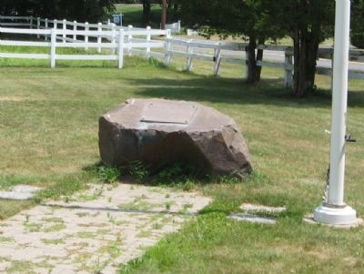
On Arch Road 0.1 miles east of West Avon Road, on the right when traveling west.
1778 1978
1st Company Governor's Horse Guards
Organized Militia – State of Connecticut
20 May, 1978
This memorial is dedicated to the Horse Guardsmen who have honorably served this illustrious cavalry unit since it's founding during . . . — — Map (db m33060) HM
On West Main Street (U.S. 202) at Ensign Drive, on the right when traveling west on West Main Street.
Avon
This area, formerly Northington or the North Parish of Farmington, was settled in 1645non land that had belonged to the Tunxis Indians. It prospered as a farming community and, in 1830, after the construction and opening of the Farmington . . . — — Map (db m33019) HM
On West Main Street (U.S. 202) at Ensign Drive, on the right when traveling west on West Main Street.
[ center panel ]
Avon Remembers
"No Greater Gift"
Mexican War
Sperry, Orrin
Civil War
Beman, Job • Booth, Austin C • Brewer, Gilbert F • Buckley, Frederick O • Calkins, Obed H • Clark, Henry W • Evans, Henry D • Evans, Newton J . . . — — Map (db m33168) WM
On Old Farms Road, on the right when traveling west.
Wilford Woodruff, fourth President of The Church of Jesus Christ of Latter-day Saints, was born 1 March 1807 in a section of Farmington, Connecticut, known as Northington (now Avon). He and his parents, Aphek and Beulah Thompson Woodruff, lived in . . . — — Map (db m92453) HM
The Artist
A charismatic Englishman with the unlikely name of Dawson Dawson-Watson came to Hartford in 1893, fresh from Giverny and its aura of Claude Monet, and set to work introducing the radical French art called
Impressionism. He taught . . . — — Map (db m102122) HM
On Albany Turnpike (U.S. 44), on the right when traveling east.
In 1829 the Farmington Canal opened in Avon and operated until 1847. The Markers, here and across the street, show where it crossed the Albany Turnpike, now Rt. 44. They are made of the same sandstone used in in the Farmington Canal construction. — — Map (db m92442) HM
On Kensington Road at Main Street, on the left when traveling north on Kensington Road.
Berlin
This land, granted to settlers in 1661 and 1668 by the General Court of Connecticut, was also purchased from the local Mattabesett Indian tribe. Founders of the community include Sergeant Richard Beckley, who came north on the trail from New . . . — — Map (db m46041) HM
On Worthington Ridge at Wildem Road, on the right when traveling south on Worthington Ridge.
1920
Erected by the Town Of Berlin
in honor of
her patriotic men and women
who served their country
in time of war
For The Dead – A Tribute
For The Living – A Memory
For Posterity – An Emblem Of Loyalty
To The Flag Of Their . . . — — Map (db m47327) WM
On Percival Avenue at Sheldon Street, on the left when traveling north on Percival Avenue.
[ north side ]
Erected to Commemorate the Death
Of Those Who Perished in Suppressing
The Southern Rebellion
How sleep the brave who sink to rest.
By all their country's wishes blest.
1863
Soldiers
[ west side ] . . . — — Map (db m46037) WM
Near John Karbonic Way at South Main Street, on the right when traveling west.
In Memory Of The
Vietnam Veterans
From New Britain
Who Lost Their Lives
In Vietnam
Pedro O. Cancel PFC. • Richard E. Chabot L/Cpl • Richard W. Roy Sp4
Michael Smith L/Cpl • Paul Thorik Jr. Cpl • Stanley J. Ciesielski Sp4 • Francisco . . . — — Map (db m41600) HM
On Park Avenue (Connecticut Route 178) at Bloomfield Avenue ( Route 189), on the left when traveling north on Park Avenue.
Bloomfield
In 1736 fifty-one inhabitants petitioned for parish privileges in what is now Bloomfield. They called the parish Wintonbury, using parts of the names of the three towns they came from Windsor, Farmingtonand Simsbury. It remained . . . — — Map (db m97354) HM
On Bloomfield Avenue (Connecticut Route 189) at Park Avenue ( Route 178), on the right when traveling north on Bloomfield Avenue.
The Town of Bloomfield
dedicates this memorial
to the 129 men who signed to
serve in the Union Army
during the Civil War 1861 – 1865
A grateful town thanks them
Dedicated Memorial Day May 28, 2012 — — Map (db m97274) WM
On Bloomfield Avenue (Connecticut Route 189) at Park Avenue ( Route 178), on the right when traveling north on Bloomfield Avenue.
Korean War Memorial
Dedicated to the Memory
of those who served for America
as part of a United Nations
team to establish a
foothold for democracy at
the thirty-eighth (38th)
parallel in Korea.
Special attention is
given to those . . . — — Map (db m97272) WM
On Bloomfield Avenue (Connecticut Route 189) at Park Avenue ( Route 178), on the right when traveling north on Bloomfield Avenue.
Vietnam Veterans
Monument
George C Kosovich Jr 11-1-65
Edward L Bieber 10-23-67
Robert S Bagnall 3-8-69
Barry Jackson 3-18-69
(back)
Dedicated to The Men
And Women of Bloomfield
Who So Bravely Answered
Their Country’s . . . — — Map (db m97270) HM
On Bloomfield Avenue (Connecticut Route 189) at Park Avenue ( Route 178), on the right when traveling north on Bloomfield Avenue.
Dedicated To The
650 Men and Women
Of Our Community
Who Fought In World War II
1941 – 1945
To These,
The Living and the Dead,
The Citizens of Bloomfield
Erected This Tablet
In Grateful Remembrance
In Loving Memory . . . — — Map (db m97282) WM
On Tunxis Avenue (Connecticut Route 189) 0.1 miles north of Wintonbury Avenue, on the right when traveling north.
( left gatepost plaque )
1736 1933
Old Wintonbury Cemetery
This gateway and fence were erected to the memory of the founders and descendants of ancient Wintonbury through the generosity of Mrs. Alice Bidwell Francis and Miss Caroline . . . — — Map (db m99742) HM
On Bloomfield Avenue (Connecticut Route 189) at Park Avenue ( Route 178), on the right when traveling north on Bloomfield Avenue.
Roll of Honor
Town of Bloomfield
1914 World War 1919
*Harry Emanuel Johnson *Patrick J. Lane *Willard Delmont Mason
Alfred Arndt • Philip A Auben • Raymond H Barnard • Arthur G Beebe • Rev Howard W Benedict • Harold F . . . — — Map (db m97352) HM
On Park Avenue (Connecticut Route 178) at Bloomfield Avenue ( Route 189), on the left when traveling north on Park Avenue.
On This Site Stood
The Bloomfield Methodist Church
From 1853 to 1961
Originally Built on Whirlwind Hill in 1832
Moved to This Site in 1853 — — Map (db m97353) HM
On Bloomfield Avenue (Connecticut Route 189) at Park Avenue ( Route 178), on the right when traveling north on Bloomfield Avenue.
The Village Green
Symbolizing the Beginnings and
Center of Community Life
The Bloomfield Village Green
Has Existed Since the 1700’s
Restored by Wintonbury Park
Redevelopment Project
Wintonbury Parish 1735
Town of Bloomfield 1835 . . . — — Map (db m97283) HM
On Canton Springs Road, on the right when traveling south.
Driving along Maple Avenue, circa 1915
Some early transportation at the corner of Maple Avenue & River Road, circa 1910
CNE Station on Canton Springs Road with cemetery in the background, circa 1900
Patrons of Cherry Park, off Lovely . . . — — Map (db m102376) HM
On Albany Turnpike (U.S. 44), on the right when traveling west.
On this site, in 1778, Phoebe Humphrey protected
her home from Hessian soldiers who were part of
Burgoyne’s captured army headed for Boston.
Because of her bravery, she became the namesake
of the Collinsville Chapter of the National Society
of . . . — — Map (db m94480) HM
On Albany Turnpike (U.S. 44) at Canton Green Road, on the right when traveling east on Albany Turnpike.
Settlement of the area later called Canton, originally part of Simsbury, began in 1737 with the erection of the Richard Case II home on East Hill. The earliest homes were constructed along “Cherry’s” brook. The settlers’ name for the . . . — — Map (db m87925) HM
On Market Street (Connecticut Route 179), on the right when traveling east.
In honor of
the men of this town
who have served our country
in her various wars for freedom
and in grateful recognition
of their heroism
and the sacrifice they made This tablet is erected by the
Canton Soldiers Memorial . . . — — Map (db m103786) WM
On Bridge Street (Connecticut Route 17) at River Street, on the right when traveling east on Bridge Street.
Canton Veterans Memorial
In Grateful Memory Of The
Men Who Died In The Service
Of Their Country And In
Recognition To All Men
And Women Who Served
That Freedom Might Live.
This Monument Stands So
That Future Generations
Will Always . . . — — Map (db m88300) WM
On Bridge Street (Connecticut Route 179), on the right when traveling west.
From the book “Connecticut Railroads” by Turner & Jacobs. Train time at Collinsville, Connecticut on the Central New England Railway. Because the main-line track was on the outskirts of town, trains actually backed into the station. This train is . . . — — Map (db m93067) HM
Central New England Railroad had several names but started in 1871 and ended in 1927. It ran from Hartford, Connecticut to Millerton, New York. The train came into this High Street Junction (on Dyer Avenue) from Simsbury. The passenger station was . . . — — Map (db m92461) HM
On River Road (Connecticut Route 179), on the left when traveling north.
Canoe Club, circa 1910- The club house was near the present-day nursery.
Note: The house in back was lost in the flood of 1955
Ice on the river, Circa 1900
View of the river from the tracks, Circa 1910
Station, circa 1911, . . . — — Map (db m92462) HM
On Lovely Street, on the left when traveling north.
Route 44 began as the Indian’s Northwest Path. It became the Hartford to Albany Road during the French and Indian War in order to move troops and equipment. In 1984, it became the Albany Turnpike, a toll road.
1776 House was an old home . . . — — Map (db m102423) HM
On Torrington Avenue (Connecticut Route 179) at Bridge Street, on the right when traveling north on Torrington Avenue.
This powerhouse was built in 1935 to house a low-head, Francis-type turbine and a General Electric remote controlled generator. The turbine and generator were purchased by The Collins Company from a municipality in Lenoir, North Carolina and . . . — — Map (db m92548) HM
On Front Street at Main Street, on the right when traveling south on Front Street.
This building was built in 1865. Here, plows were assembled, painted, labeled and stored. By 1870, the Collins Company was producing 100 plows a day.
The introduction of the tractor and gasoline powered farm equipment eventually made hand . . . — — Map (db m93373) HM
Near Newgate Road 0.3 miles north of Valley View Drive, on the left when traveling north.
In 1805, the state organized the construction of this now ruinous three-story building. This multi-use structure served as a kitchen, storeroom, shoe shop, and makeshift hospital for sick or injured prisoners. Firsthand accounts from prisoners, . . . — — Map (db m248840) HM
Near Newgate Road 0.3 miles north of Valley View Drive, on the left when traveling north.
Everyday needs such as eating, bathing, and going to the bathroom were much more difficult in prison. This foundation is thought to be a latrine for the prison guards and officials. As for the prisoners, one of the overseer's reports states that a . . . — — Map (db m248848) HM
On Center Street at Memorial Drive, on the left when traveling south on Center Street.
East Granby
This area, first settled in 1664, was one of four Congregational parishes in Simsbury. The Turkey Hills Ecclesiastical Society in 1786 became a section of Granby, and in 1858 was incorporated as the Town of East Granby. An unusual . . . — — Map (db m97408) HM
On South Main Street at Memorial Drive, on the left when traveling south on South Main Street.
East Granby
Roll of Honor World War II
Aldrich, Howard E. • Alexander, George • Archambault, Lloyd L. • Barnes, George F. • Bartkus, Edward A. • Bartkus, Ernest F. • *Bartkus, Ferdinand • *Bates, William e. Jr. • Bazyk, David F. • . . . — — Map (db m97410) WM
Near South Main Street at Memorial Drive, on the left when traveling south.
1917 East Granby 1919
Roll of Honor World War
Christian H. Ahrens • George H. Ahrens • Rena Ahrens • Stanley Bazyk • Charles W. Bishop • Eugene Bolden • Stanley Boultrish • Steve Brozatsky • Harry Whitehead Case • Coulter M. Cook • . . . — — Map (db m97411) WM
Near Newgate Road 0.3 miles north of Valley View Drive, on the left when traveling north.
In 1774, following several successful escapes, the General Assembly instructed that a log house be built over the original mineshaft to prevent further prison escapes. In 1777 prisoners attempting to escape via this mineshaft burned the guardhouse . . . — — Map (db m248847) HM
Near Newgate Road 0.3 miles north of Valley View Drive, on the left when traveling north.
In February 1781, officials oversaw the construction of a picket fence around the prison yard to improve security. In 1802, Colonel Calvin Barber from Simsbury built the twelve-foot stone wall enclosing a 180 x 160 foot prison yard. The new wall . . . — — Map (db m248859) HM
Near Newgate Road 0.3 miles Valley View Drive, on the left when traveling north.
During the colonial period, it was illegal to smelt ore in the colonies, so colonial mine operators like those at New-Gate were forced to ship the ore to England. After the prison closed in 1827, the Phoenix Mining Company and the Connecticut . . . — — Map (db m248863) HM
Near Newgate Road 0.3 miles north of Valley View Drive, on the left when traveling north.
Old New-Gate Prison
Has been designated a
registered national
historic landmark
Under the provisions of the
Historic Sites Act of August 21, 1935
This site possesses exceptional value
in commemorating or illustrating
The history of . . . — — Map (db m248830) HM
Near Newgate Road 0.3 miles north of Valley View Drive, on the left when traveling north.
Copper Mine
Old New-Gate is the site of the first chartered copper mine in the North American colonies; it is a historic and physical representation of the type of commercial business that colonists needed to establish to reduce dependency . . . — — Map (db m248860) HM
Near Newgate Road 0.3 miles north of Valley View Drive, on the left when traveling north.
Old New Gate Prison and Copper Mine
have been designated a
national historical landmark by
American Society for Metals
First copper mine chartered in America and is
believed to be the first copper mine in the
thirteen original colonies. . . . — — Map (db m248827) HM
On South Main Street at Memorial Drive, on the left when traveling south on South Main Street.
Planted in Memory of
George W. Pepe
and
William E. West
Killed in the Vietnam Conflict
East Granby Jaycees
and
Jaycee Wives
May 1973 — — Map (db m97448) WM
Near Newgate Road 0.3 miles north of Valley View Drive, on the left when traveling north.
In an attempt to heighten security, New-Gate officials built a guardhouse. The warden's quarters were in the front section of the house, and the back two sections were provided that descended to the storage, cells, and mine.
Guarding the . . . — — Map (db m248844) HM
Near Newgate Road 0.3 miles north of Valley View Drive, on the left when traveling north.
The 1790 structure, the remains of which you see in this corner of the prison yard, served as the work house, primarily for making nails. One goal of the colony in opening New-Gate Prison was "profitably employing" prisoners. Still, experienced . . . — — Map (db m248862) HM
Near Newgate Road 0.3 miles north of Valley View Drive, on the left when traveling north.
As the number of prisoners grew, additional buildings were erected consisting of workshops, a chapel, a hospital, and a four-story cell block to house the overflow population and move inmates out of confinement in the mine.
These ruins mark . . . — — Map (db m248842) HM
Near Newgate Road 0.3 miles north of Valley View Drive, on the left when traveling north.
State officials evaluated New-Gate's success largely by how much money the prison earned and how few prisoners escaped. By the 1820s, the General Assembly became increasingly concerned about overcrowding, unsanitary conditions, and the failure of . . . — — Map (db m248835) HM
Near Newgate Road 0.3 miles north of Valley View Drive, on the left when traveling north.
Miners determined their path based on the vein of copper they followed. Eventually the vein brought them to this point, 75 feet below ground. The need for a second ore shaft arose to haul the valuable ore to the surface.
New-Gate's first . . . — — Map (db m248843) HM
Near Newgate Road 0.3 miles north of Valley View Drive, on the left when traveling north.
You are currently standing in the location of the historic nail shop at New-Gate Prison, where incarcerated men made wrought iron nails as part of their forced prison labor. Much of what we know about life at New-Gate comes from historic documents . . . — — Map (db m248864) HM
On Main Street at Carroll Road, on the right when traveling north on Main Street.
East Hartford
This part of the lands once inhabited by the Podunk Indians saw its first permanent colonists in 1655, when Thomas Hooker and his followers came from Cambridge, Massachusetts, to found Hartford. The east side of the Connecticut River . . . — — Map (db m74248) HM
On Main Street at Phelps Place, on the right when traveling north on Main Street.
( north side )
Alvin Flint, Co. B. 21. Reg. C.V. Died Jan. 10, 1863. Aged 53.
Alvin Flint, Jr. Co. D. 11. Reg. C.V. Killed at Antietam, Sept. 17, 1862. Aged 17.
George B. Flint, Co. B. 21. Reg. C.V. Died at Falmouth, Va. Jan. 14, 1863. . . . — — Map (db m74953) WM
On Main Street at Central Avenue, on the right when traveling north on Main Street.
1917 ― 1918
In Honor Of
The Men And Women Of
East Hartford
Who Answered
Their Country’s Call
To Service In The
World War
To The Dead A Tribute
To The Living A Memory
To Posterity A Token
Of Loyalty
To The Flag Of . . . — — Map (db m74740) WM
On Burnside Avenue (U.S. 44) at Westbrook Street, on the right when traveling east on Burnside Avenue.
Dedicated
To The Memory
Of Our Youth
Who Gave
Their Lives
In
World War II
* * *
“Let none forget they gave their all
And faltered not when came the call”
( memorial stone behind the monument )
Dedicated to . . . — — Map (db m74245) WM
On Main Street at Phelps Place, on the right when traveling north on Main Street.
Historic Center Cemetery
Authorized 1709
“Center Cemetery is one of Connecticut’s most interesting and important 18th century burial grounds, and is one of the most striking examples extant of the mixing of Connecticut River Valley . . . — — Map (db m74928) HM
On Main Street at Gold Street, on the left when traveling north on Main Street.
On Tuesday, April 15, 1817, in a building located on this site, the Connecticut Asylum for the Education of Deaf and Dumb Persons officially opened. The school was the first in America to teach deaf children and had a class of seven syudents. The . . . — — Map (db m52437) HM
On Main Street at Church Street, on the right when traveling south on Main Street.
Christ Church
Cathedral
Diocese of Connecticut
Episcopal
Founded as Christ Church 1762
Set Apart as Cathedral 1919
Present Building 1828
The Rt. Rev. Ian T. Douglas
Bishop of Connecticut
The Very Rev. Mark B. Pendleton . . . — — Map (db m44074) HM
On Main Street at Capitol Avenue, on the right when traveling north on Main Street.
Pulaski
"I came here, where freedom is being defended, to serve it, and to live or die for it . . ."
General Casimir Pulaski
was born in Poland in 1748. He led the unsuccessful revolt of Polish Patriots against Russia. Upon arrival in America . . . — — Map (db m52343) HM
On Main Street at Gold Street, on the right when traveling south on Main Street.
Hartford was named in 1637 after the English town of Hertford. The Indian name was Suckiaug. The first colonial settlement, called House of Good Hope, was made by the Dutch in 1633. The Reverend Thomas Hooker arrived overland from Newtown . . . — — Map (db m43708) HM
On Scantic Road near Phelps Road, on the right when traveling south.
East Windsor
Separated from Old Windsor and constituted a township on the “second Thursday of May A.D. 1768”. In this area was the Nortin Society of Old Windsor, organized in May 1752. Ferry service established by John Bissell in 1641 . . . — — Map (db m113964) HM
On Bridge Street (Connecticut Route 140) at Main Street ( Route 510), on the left when traveling west on Bridge Street.
In Tribute to Those Men and Women of This Community Who Nobly Answered Their Country’s Call by Patriotic Service In All Her Wars Beginning With The Founding of The American Colonies.
Dedicated May 30, 1938 by Barry - Poulter Post No 40 . . . — — Map (db m114599) WM
On Scantic Road at Phelps Road, on the left when traveling south on Scantic Road.
Site of
Constitutional Oak
Commemorating the Connecticut Constitutional
Convention of 1902
Presented to Harold A. Middleton East Windsor Delegate
Erected by East Windsor Historical Society 1966 — — Map (db m113970) HM
On Rye Street near Old Ellington Drive, on the left when traveling south.
For Democacy
Erected in Memory of Our Boys in the Town of
East Windsor, Conn. Who, in the Time of Out Country’s
Need, Willingly Laid Aside Their Duties to Enter
The World War Offering Their Lives and Sacred
Honor On the Altars of Our . . . — — Map (db m113957) WM
On Rye Street at Old Ellington Drive, on the left when traveling south on Rye Street.
Spirit of Unity
Time Capsule
To be Opened June 10, 2092
Dedicated June 10, 1992
To the People
of
East Windsor, South Windsor and Ellington
Who united in purpose on June 10, 1991 to oppose
the siting of a radioactive dump in order to . . . — — Map (db m113960) HM
On Hazard Avenue (Connecticut Route 190) at North Street, on the right when traveling west on Hazard Avenue.
This Memorial Erected
In Honor of the Men and Women
Of Hazardville, Who Served
Their Country in The Armed
Forces Preserving Our
Freedom and Our Way of Life
During World War II — — Map (db m113855) WM
On Hazard Avenue (Connecticut Route 190) at North Street, on the right when traveling west on Hazard Avenue.
This Flagpole Erected In Memory Of
SFC Lawrence A. Dufraine
May 27, 1968 — Aug. 1, 2004
Dedicated May 27, 2006
By His Family and Friends — — Map (db m113857) WM
On Enfield Street (U.S. 5) at S. Road, on the left when traveling north on Enfield Street.
Established as the township of Enfield, 1683, this area was part of the Springfield Plantation granted to William Pynchon and others by the Massachusetts General Court. Springfield was settled in 1636, but no effectual grants were made here until . . . — — Map (db m301997) HM
On Enfield Street at N. Main Street, on the left when traveling north on Enfield Street.
This Space is Dedicated to The Veterans of Our Community Who Served The Nation In Time of Danger
This We’ll Defend · Semper Fidelis · Don’t Tread On Me · Aim High Fly-Fight-Win · Semper Paratus · Acta Non Verba
Some Are With Us Still
Many . . . — — Map (db m113880) WM
On Church Street at N. Main Street, on the right when traveling south on Church Street.
In memory
of the men of Enfield
who
on land and sea
periled their lives
for Union
and liberty, 1861-1865.
Erected by the
Town of Enfield
A.D. 1885.
Roll of Honor
Killed in Battle
Maj. Theo. H. Rockwood · . . . — — Map (db m113882) WM
On Enfield Street near N. Main Street, on the left when traveling south.
This Memorial Erected In Honor Of
The Men and Women of This Community
Who Served Their Country In the
Armed Forces Preserving Our Freedom
And Our Way Of Life
To The Memory Of Those Who Served
In The Global War On Terror
Those Who Paid . . . — — Map (db m113858) WM
On Enfield Street at N. Main Street, on the left when traveling north on Enfield Street.
Enfield, Connecticut
World War II Honor Roll
( 2,246 names are inscibed. These have stars next to their name, indicating that they gave their lives. )
Arrowsmith, John W. Jr. · August, Kenneth E. · Austin, David T. · Bannon, Edmund . . . — — Map (db m113928) WM
On Enfield Street at Spier Avenue, on the left when traveling south on Enfield Street.
Near this site the first church building in Enfield was erected by pioneer settlers in 1684.
Placed by Penelope Terry Abbey Chapter, D.A.R.
1680 1930 — — Map (db m113886) HM
On Enfield Street at Spier Avenue, on the left when traveling south on Enfield Street.
To Honor the Memory of the Founders of the Town of Enfield. Who led by John Pease, Jr. and his Brother Robert made the First Settlement in 1680.
Placed by Penelope Terry Abbey Chapter, D.A.R.
1680 1930 — — Map (db m113885) HM
On Enfield Street (U.S. 5) at S. Road, on the left when traveling south on Enfield Street.
Thomas Abbey Born April 11, 1731. Died June 3, 1811.
A soldier in the French and Indian Wars. Took part in the capture of Fort Ticonderoga, 1758, and the conquest of Canada, 1761. Corporal First Regiment, Connecticut Troops, May 25 to . . . — — Map (db m113925) HM WM
On Main Street (Connecticut Route 10) at Maple Street, on the left when traveling north on Main Street.
American Board of Commissioners
For Foreign Missions
Here, on September 5, 1810, in the parsonage of the Reverend Noah Porter, minister of the Congregational Church of Farmington, Connecticut, the American Board Of Commissioners for . . . — — Map (db m33015) HM
The Unionville Feeder Canal joined the Farmington Canal here, providing the water from Granby to New Haven. You are standing on the “Long Level”, 26 miles without a lock. 1828-1847. — — Map (db m92153) HM
On Montieth Drive at Farmington Avenue ( Route 4), on the right when traveling east on Montieth Drive.
On January 16, 1640 the Connecticut General Court empowered a committee to "view those parts by Vnxus Sepus wch may be suitable" for settlement. Soon afterward a small group of families traveled nine miles westward over the hills from . . . — — Map (db m33066) HM
On Main Street (Connecticut Route 10) at School Street, on the right when traveling south on Main Street.
Known in the 1800’s as “the hub” of Connecticut’s Underground Railroad, Farmington was home to an active group of prominent and outspoken abolitionists, several of whom were involved in state, national and international anti-slavery . . . — — Map (db m95984) HM
On Farmington Avenue (Connecticut Route 4) at Main Street ( Route 10), on the left when traveling east on Farmington Avenue.
Lest We Forget
In honor and grateful remembrance of our French Allies in the Revolution, whose army, under the command of General Count de Rochambeau, marched past this spot enroute from Newport and Providence, R.I., to join General Washington on . . . — — Map (db m190186) HM
Site of U.S. Army Air Corps P47 Thunderbolt plane crash in which the pilot Second Lieutenant Vincent Hugh Core died on April 11, 1945 — — Map (db m91860) HM WM
On Garden Street, on the right when traveling south. Reported missing.
On this site in 1828 was located "Pitkin's Basin" for the Farmington Canal Company.
On November 10, 1828 the packet boat "James Hillhouse" was launched here on its first voyage to New Haven from port of Farmington.
The gray building . . . — — Map (db m106441) HM
The Farmington Canal crossed various topographic features- rivers, hills, roads and woodlands. Boats traveling the length of the canal passed through 28 locks that compensated for changes in elevation. Perhaps the most impressive engineering . . . — — Map (db m111590) HM
On Waterville Road at Aqueduct Lane, on the right when traveling south on Waterville Road.
The Farmington Canal
The 56-mile Farmington Canal was Connecticut's super-highway of the 1830s and 1840s. Begun in 1825, the canal was the largest engineering project ever attempted in New England. Inspired by the commercial success of the . . . — — Map (db m33017) HM
In the middle 1800s, it is believed, the cave was the home of Farmington’s mystery man, Will Warren. He was a poor farmhand with no property of his own. He refused to attend the village church on Sundays and spent his free time with the few Native . . . — — Map (db m92260) HM
On Town Farm Road, on the right when traveling south. Reported missing.
The Unionville Feeder Canal crossed here, providing most of the water for the Farmington Canal, from Granby, CT to New Haven, CT 1828-1847. — — Map (db m127444) HM
Unionville has used Farmington River water power since the late 1700s. The first dam (item D1 on map 1 and Photograph P1), built circa 1780, was just 200 yards upstream from the Route 4 bridge. The canal from this dam was on the west side of . . . — — Map (db m95986) HM
On Farmington Avenue (Connecticut Route 4), on the right when traveling west.
Also known as Rainbow Park, Suburban Park was owned and operated by the Farmington Street Railway Company, which charged fifteen cents for the one hour and fifteen-minute ride from Hartford. At thirty-five acres, the park extended well into . . . — — Map (db m134917) HM
621 entries matched your criteria. The first 100 are listed above. Next 100 ⊳