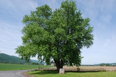
On River Road at Local Route 436, on the right when traveling west on River Road.
On this site stood the original building of Pine Creek Presbyterian Church organized 1792
Became Presbyterian Church of Jersey Shore 1851 — — Map (db m65553) HM
Under this huge Elm, July 4, 1776, resolves declaring independence were drawn, prior to news of action by Congress at Philadelphia. This was an expression of the spirit common to the frontier and led by the famous Fair Play men. — — Map (db m65556) HM
On Frank D. O'Reilly Highway (U.S. 220) at Tiadaghton Avenue, on the right when traveling north on Frank D. O'Reilly Highway.
Here, on July 4, 1776, the pioneer settlers of the West Branch resolved independence from Britain. This historic tree still stands about two miles from here at the junction of the Susquehanna and Pine Creek. — — Map (db m150087) HM
On Main Street (Pennsylvania Route 150) at Church Street, on the left when traveling east on Main Street.
This bell [formerly] atop
The Beech Creek Memorial Presbyterian Church
now The Friendship Community Center,
was purchased from the Center by
Sara McGhee and given to this
community for preservation by
Miss McGhee in memory of her . . . — — Map (db m275240) HM
On Wynn Avenue 0.1 miles south of Eagle Valley Road ( Route 150), on the right when traveling south.
VETERANS
Allen, Calvin R. • Allen, George • Allen, Kenneth E. • Allen, Steven T.
Andresky, Nikolai L. • Andrus, Leon S. • Andrus, Robert W.
Andrus, Manuel L. • Asta, Theodore E. • Aurand, William F.
Bachman, Alan L. • . . . — — Map (db m275298) WM
On Wynn Avenue 0.1 miles south of Eagle Valley Road ( Route 150), on the right when traveling south.
In honor of those who served
Army • Navy • Marines • Air Force • Coast Guard
WWI • WWII • Korea • Vietnam • Panama/Grenada
Desert Storm • Operation Enduring Freedom — — Map (db m275293) WM
On Woodward Avenue (Pennsylvania Route 150) 0.2 miles west of Fargus Island Road, on the right when traveling east. Reported missing.
Many Indian nations have occupied the Great Island in the river just south of here. Trails led from the Genesee, Ohio, Potomac, and Susquehanna North Branch. Delawares and Shawnees stopped here for a time on their migration west. — — Map (db m65555) HM
On Kettle Creek Road (Pennsylvania Route 4001) at Spice Wood Run Road, on the right when traveling south on Kettle Creek Road.
Against expert advice, Dorcie Calhoun drilled Leidy Township's first successful deep gas well about a quartermile south of here. On January 8, 1950, the well hit natural gas at a depth of 5,659 feet, and for a time it brought up an estimated 15 . . . — — Map (db m65551) HM
On Piper Way north of Bald Eagle Street, on the left when traveling north.
Howard Piper, who was head of product development at Piper, asked Ed Swearingen to create a twin version of the PA-24 Comanche. Howard didn't always get what he wanted from the engineers inside Piper. Accordingly in June 1960, Ed Swearingen . . . — — Map (db m275078) HM
Piper had started a Light Trainer project at Vero Beach in 1969, designated the PA-38. The concept definition called for the aircraft to compete with the Cessna 150 in the 1970-1980 timeframe. Piper canvassed thousands of flying instructors . . . — — Map (db m275079) HM
On Water Street (Pennsylvania Route 120) west of Jay Street ( Route 664), on the right when traveling west.
As of 2024, about 600 Clinton Countians
have served in the Middle East since
2001. MAJ Thomas J. Motel was awarded
the Bronze Star for his service in
Afghanistan with the 452nd Medical
Detachment. SSG Jeffrey D. Rembold
engaged in airborne . . . — — Map (db m275142) HM WM
On Water Street east of Jay Street ( Route 664), on the left when traveling east.
The Bald Eagle Cross Cut Canal
The Bald Eagle Cross Cut Canal was built between 1828 and 1834, and ran from Lock Haven to Bellefonte. The canal was created to improve inland navigation. The locks that were a part of the canal eventually led . . . — — Map (db m251746) HM
On Church Street (Pennsylvania Route 150) at Bellefonte Avenue ( Route 150), on the left when traveling east on Church Street.
In memory of the
loyal sons who offered
their lives in defense
of the Union.
With malice toward none,
with charity for all.
Population of Clinton County in 1861. 17723.
Number of soldiers enlisted from
Clinton County 1938. . . . — — Map (db m251722) WM
On North Jay Street (Pennsylvania Route 120) at East Water Street, on the right when traveling south on North Jay Street.
Formed on June 21, 1839 out of Lycoming and Centre counties. Named probably for New York's Gov. DeWitt Clinton. Site of "Tiadaghton Declaration of Independence," 1776. In 19th century a lumbering center. Lock Haven, the county seat, became a city . . . — — Map (db m65547) HM
On Bald Eagle Street, on the left when traveling east.
(Bronze Plaque) American Revolution 1775-1784 Buried in Clinton County-Dedicated 1976 William Baird, James Caldwell, John C. Culvey, Thomas Curts, J. P. De-Hass, William Dunn, Brewster Freeman, Peter Grove, James Hays, John W. Kister, Robert . . . — — Map (db m91070) WM
On Bald Eagle Street, on the left when traveling west.
Dedicated in memory of the men and women
of Clinton County who sacrificed their lives
during World War II.
Allison, David R. • Ammon, William C. • Anderson, Harry P. • Anton, Joseph E.
Arndt, James C. • Bailey, Donald E. • Barrile, . . . — — Map (db m275146) WM
On Jay Street (Pennsylvania Route 664) at Water Street, on the right when traveling north on Jay Street.
Lock Haven...looking to the future, warmly remembering its past!
Nestled between the West Branch of the Susquehanna River and the scenic mountains of Central Pennsylvania, Lock Haven has small town charm and a rich historical architectural . . . — — Map (db m251748) HM
On 1st Street at Church Street, on the right when traveling south on 1st Street.
In gratitude for the ministry of the former
First Evangelical Lutheran Church
and
St. John's Evangelical Lutheran Church
of Lock Haven, Pennsylvania
and as a reminder of our heritage
This Bell
from the First Evangelical Lutheran . . . — — Map (db m251729) HM
On West Water Street (Pennsylvania Route 120) at 6th Street, on the right when traveling east on West Water Street.
William Reed's stockaded house was the westernmost defense for Susquehanna Valley settlers. The site of the pioneer outpost is a few blocks ahead at the monument near the bridge. — — Map (db m65549) HM
On East Bald Eagle Street at Race Street on East Bald Eagle Street.
This playfield was made ours through the assistance of the Harmon Foundation 1927. Dedicated forever to the plays of children, the development of youth and the recreation of all. "The gift of land is the gift eternal" — — Map (db m91071) HM
On Water Street (Pennsylvania Route 120) west of Jay Street ( Route 664), on the right when traveling west.
Operation Iraqi Freedom began in March
2003. PO2 John W. Varner served aboard
the USS Harry S. Truman, where he
supervised the upload of bombs and
missiles for over 1,200 airstrikes in Iraq.
MAJ John J. Williamson was a company
commander . . . — — Map (db m275144) HM WM
Dedicated to the enjoyment of
students, alumni, and friends of
Lock Haven University as testament
to the many individuals who
enhance the lives of students
Donated in 2003 by
Ron Jury '72 — — Map (db m275172) HM
On Water Street (Pennsylvania Route 120) west of Jay Street ( Route 664), on the right when traveling west.
In Korea, three county men earned Silver
Stars for gallantry in action: PFC Gene F.
Riggle, 8th Cavalry, killed near Taegu on
September 3, 1950; CPL Raymond E.
Heaton, 27th Infantry, killed near
Tongduchon on March 30, 1951; and SGT
Floyd . . . — — Map (db m275136) HM WM
On Water Street (Pennsylvania Route 120) west of Jay Street ( Route 664), on the right when traveling west.
Clinton County honors its citizens who made the ultimate sacrifice for their country. You will always remain our heroes.
PFC Donald R. Abel · Westport • PVT Landis L. Button · North Bend
CPL Boyd W. Cassidy · Drurys Run • 2LT Edward M. Crays . . . — — Map (db m275113) WM
On East Water Street 0.1 miles east of North Jay Street, on the right when traveling east.
Named by the founder Jerry Church for this old canal lock built by the state of Pennsylvania 1834 the haven for rafts created by the dam. — — Map (db m65552) HM
On North Jay Street (Pennsylvania Route 120) at East Water Street, on the right when traveling north on North Jay Street.
Dedicated to the people of Lock Haven to secure protection from the ravaging floods of Susquehanna River and to promote economic stability for future growth.
Dedicated
October 14, 1994
Local Cooperation Agreement
March 14, 1991
. . . — — Map (db m79973) HM
On Fairview Street north of Glenn Road, on the left when traveling north.
This Bald Eagle statue was gifted to Lock Haven University from the Class of 1966. It symbolizes the pride of generations of Lock Haven students, alumni, and the entire Lock Haven and campus communities.
Thank You to All of our . . . — — Map (db m275157) HM
"To learn something new, take the
path that you took yesterday." - John Burroughs
In the early 1930s the LHU Naturalist Club blazed a nature trail that runs through the woods on the hill above you. In 2014 the . . . — — Map (db m275182) HM
On East Main Street (Pennsylvania Route 150) 0.1 miles east of North Jay Street, on the right when traveling west.
Division was built from Northumberland to Lock Haven in 1828-34. Until 1889, carried iron, lumber, and manufactures from this area to eastern markets. Here Bald Eagle Cross-Cut Canal joined the division, connecting with it by two locks, a dam, . . . — — Map (db m150086) HM
On Water Street (Pennsylvania Route 120) west of Jay Street ( Route 664), on the right when traveling west.
About 100 Clinton Countians served in
Operation Desert Storm. SSG John
Schenck, Jr., repaired F-15 Eagles with
the 1st TFW, the first unit deployed to the
Persian Gulf in response to the Iraqi
invasion of Kuwait in August 1990. SSG
Barry . . . — — Map (db m275139) HM WM
On Piper Way north of Bald Eagle Street, on the left when traveling north.
Founded as Taylor Bros. in 1927. In the 1930s William T. Piper purchased the company and moved it to Lock Haven in 1937, rebranding as Piper Aircraft Corp. Employed more than 2,000 people at its height. Manufactured nearly 77,000 general . . . — — Map (db m275076) HM
Commemorating the
distinguished service to education
of
Albert N. Raub, A.M., Ph.D.
First Principal of
the Central State Normal School
1877 - 1884
Dedicated May 21, 1966 — — Map (db m275179) HM
On Campus Drive west of Fairview Street, on the left when traveling west.
Constructed in 1896 as the Central State Normal School Gymnasium,
and renovated in 2005, this is the oldest structure on campus. In 1953,
it was named in memory of James Rogers '49, who lost his life to
Hodgkin's disease in 1952. He was . . . — — Map (db m275188) HM
On Water Street at Jay Street ( Route 664), on the left when traveling east on Water Street.
David M. Collins was born and raised in Lock Haven, Pennsylvania, and graduated from Lock Haven High School in 1987. In April 1988, he enlisted in the U.S. Navy and served on the USS Independence (CV62) during the Gulf War. In 1991, he successfully . . . — — Map (db m91069) WM
On Water Street (Pennsylvania Route 120) near Jay Street ( Route 664).
More than a thousand Clinton County men
served in the Civil War. PVT Cyrus M.
Walker of the 7th PA Cavalry fought with
the Army of the West at Chickamauga,
Chattanooga, and Murfreesboro. PVT
Walker died in 1946 at age 103. CPL DeWitt
C. . . . — — Map (db m275120) HM WM
On Water Street (Route 120) near Jay Street (Route 664), on the right when traveling west.
During the American Revolution (1775-83),
what is now Clinton County was the
northern frontier of Northumberland
County. In 1776, William McElhattan,
Robert Love, William Dunn, and many
others answered the call for independence
and reported . . . — — Map (db m275118) HM WM
On Fairview Street at Water Street/Campus Drive, on the left when traveling north on Fairview Street.
Gift of
Samuel Harvey Fredericks Jr
and his wife
Carol Whitcraft Fredericks
to
Lock Haven University and
the Community of Lock Haven — — Map (db m275156) HM
On Water Street east of Jay Street ( Route 664), on the left when traveling east.
Covered Bridge
The Jay Street Bridge was once one of the oldest and longest covered bridges in Pennsylvania, spanning more than 800 feet. It was built in October of 1852 by E. Kirkbride and Company under the auspices of the Lock . . . — — Map (db m251742) HM
What is the Susquehanna Greenway? The Susquehanna Greenway is a corridor of farms, forests, parks, trails and river towns that connects people to the natural and cultural treasures of the Susquehanna River. Nearly 500 miles in length, it is . . . — — Map (db m91037) HM
On Jay Street (Pennsylvania Route 664) at Water Street, on the right when traveling north on Jay Street.
Dedicated to
Veterans of Clinton County
William Marshall Crawford Post 131 • Bitner-Bechdel Post 623
Remembrance Post 442 • Martin-May Post 284 • W.W.I Barracks 2941
40 et 8 Voiture 903 • V.F.W. Post 1630 • D.A.V. Chapter 116 . . . — — Map (db m251739) WM
On Water Street (Pennsylvania Route 120) west of Jay Street ( Route 664), on the right when traveling west.
Over 1,100 Clinton Countians served in
the military during the Vietnam War. SP5
Mary Lee Motter, SP4 Patricia M. Powell,
and SP5 Peggy A. Sheasley were among
the county women in uniform. CAPT
Richard W. Day flew F-102 Delta Daggers
over . . . — — Map (db m275137) HM WM
On Water Street (Pennsylvania Route 120) west of Jay Street ( Route 664), on the right when traveling west.
In Honor of the Clinton County Vietnam Veterans who lost their lives...
and those who continue to suffer the effects of war.
PFC Larry K. Barner · Army • PSGT Kenneth L. Culvey · Army
SSGT George E. Eaton · Army • LCPL John J. Edwards · . . . — — Map (db m275116) WM
On Water Street (Pennsylvania Route 120) west of Jay Street ( Route 664), on the right when traveling west.
In 1917, MAJ George D. Green, a doctor at
the Lock Haven Hospital, organized the
305th Ambulance Company, a group of
about 200 local volunteers including SGT
Clyde A. Stouck, PFC Linford W. Rogers, and
PVT William H. Raymond, one of the . . . — — Map (db m275127) HM WM
On Water Street (Pennsylvania Route 120) west of Jay Street ( Route 664), on the right when traveling west.
Two county men earned Silver Stars during
the drive through Italy in 1943-44: MSG
Henry S. Furst, 82nd Airborne, for gallantry
in action at Salerno and Anzio; and SGT
Gordon R. Shaffer, 141st Infantry, for his
part in crossing the Gari River . . . — — Map (db m275128) HM WM
On Water Street (Pennsylvania Route 120) west of Jay Street ( Route 664), in the median.
SSGT Frank J. DePolis of the Army Air
Corps, PFC Daniel D. Confer of the 16th
Coast Artillery, and S1C Demonte W. Temple
of the USS Perry were at Pearl Harbor on
December 7, 1941. SSGT DePolis was killed.
LT Jeraldine E. Jones of the Army . . . — — Map (db m275131) HM WM
On Interstate 80 at milepost 194, on the right when traveling west.
Timbering — Clinton County, at one time of settlement was considered one of the most remote parts of Pennsylvania. It is likely that during this early time most of the area was densely covered with white pine, eastern hemlock, and hardwoods . . . — — Map (db m176028) HM
On Interstate 80 at milepost 194, on the right when traveling west.
our history
There's no telling exactly how many elk once roamed free throughout Pennsylvania. From the Allegheny National Forest to Kettle Creek State Park, the loud bugles of the male bulls could be heard calling the female cows to mate. . . . — — Map (db m176035) HM
On Main Street (Pennsylvania Route 880) east of Mill Street ( Route 477), on the right when traveling east.
Frank Barner • Walter Barner Jr. • Dean Bartges • Elwood Bartges • Glen Bierly
Harry Boone • James Breon • Jason Breon • Frank J. Brungard • Boyd Cashner
Donald Confer • Harry Conoway • Warren Cooper Sr. • Alton L. Currin
Ronald Douty • . . . — — Map (db m184629) WM
On Main Street (Pennsylvania Route 880) east of Mill Street ( Route 477), on the right when traveling east.
Killed In Action
David A. Cooper, Jr.
Honor Roll
Darren M. Barnard • Eric M. Barner • Gregory R. Barner • Walter G. Barner
Dustin E. Best • Scott E. Bixel • Nicole A. Bressler • Scott M. Brungard
Brandon W. Cherry • Michael L. . . . — — Map (db m184549) WM
On Main Street (Pennsylvania Route 880) east of Mill Street ( Route 477), on the right when traveling east.
Killed In Action
Larry Barner
Honor Roll
Alvin Aikey • William Andrews • George Baney • Boyd Barner • Jerry Barner
Steve Barner • Walter Barner • Carl Beck • Ralph Beck • Glen Bierly • James Bower
Barry Breon • Donald Breon • . . . — — Map (db m184623) WM
On Main Street (U.S. 880) east of Mill Street ( Route 477), on the right when traveling east.
Died In Service
Gordon Bletz • Parse Breon • William Frankenberger
Lawrence Jackson • Merrill Reeder
Honor Roll
Andrew Anderson Jr. • John Barner • Ross Beschler • Guy Bierly • Ernest Bower
Jason Breon • Eugene Bressler • . . . — — Map (db m184653) WM
On Main Street (Pennsylvania Route 880) east of Mill Street ( Route 477), on the right when traveling east.
Killed In Action
John McCauley • Samuel Musick • Francis Simcox
Fred Vance • Oscar Wetzel
Honor Roll
Glenn Adams • Harold Adams • Floyd Barner • Glenn Bierly • Glenn E. Bierly
John Bierly • Raymond Bierly • Richard Bierly • . . . — — Map (db m184656) WM
On Interstate 80 east of East Valley Road, on the right when traveling east.
Timbering — Clinton County, at one time of settlement was considered one of the most remote parts of Pennsylvania. It is likely that during this early time most of the area was densely covered with white pine, eastern hemlock, and hardwoods . . . — — Map (db m282643) HM
On Eagle Valley Road (Pennsylvania Route 150) at Homestead Drive, on the right when traveling west on Eagle Valley Road.
By the Indian path along Bald Eagle Creek, in 1772, Bishop Ettwein, Moravian, brought some 200 Christian Mohicans and Delawares from Friedenshuetten, near Wyalusing, to Friedensstadt on the Beaver. — — Map (db m65550) HM
Near Kettle Creek Road (Pennsylvania Route 4001) 1.1 miles south of Sugar Camp Road.
In memory of Simeon Pfoutz and wife Susannah, first white settlers on Kettle Creek. He selected this site in 1813, cleared the land, built a log house, went to Perry Co. for his wife, two year old son Simon, and returned in 1814 to spend the rest of . . . — — Map (db m65554) HM
On Nittany Valley Drive (Pennsylvania Route 64) 0.4 miles north of Long Run Road ( Route 477), on the right when traveling north.
Governor of Pennsylvania, 1895-1899; born, 1849, on a farm 4.5 miles southeast of here. During his term, the State Department of Agriculture was created and the present State Capitol planned. Lived most of his life in Bellefonte. Died there in 1903. — — Map (db m65548) HM
On Pennsylvania Route 880 at Narrows Road, on the right when traveling west on Pennsylvania Route 880.
[Roll of Honored Dead]
John McCauley • Samuel Musick • Francis Simcox
Fred Vance • Oscar Wetzel
[Honor Roll of Veterans]
Glenn Adams • Harold Adams • Floyd Barner • Glenn Bierly • Glenn E. Bierly
John Bierly • Raymond Bierly • . . . — — Map (db m226499) WM
On Mill Street (Pennsylvania Route 487) 0.1 miles south of Shichshinny Road ( Route 239), on the right when traveling south.
Alarmed about draft resistance, the federal government deployed 800 troops to the Fishing Creek Valley in August 1864 to suppress the opposition. Peace Democrats suspected of Confederate sympathies were questioned at the Christian church near this . . . — — Map (db m89911) HM
On 3rd Street at Mack Street, on the right when traveling west on 3rd Street.
Dedicated to all firefighters, police officers,
EMS workers and all others
who lost their lives to the tragic events of
September 11, 2001
and all those who carry on.
These metal fragments are
from remains of the Twin Towers that . . . — — Map (db m134844) HM WM
On Market Street north of 4th Street, on the right when traveling north.
(front)
1747 — Evan Owen — 1819
Purchaser of the Site
and
Founder of the Town.
- First Settlers -
1786
Robert and John Brown
named the town Berwick,
after Berwick-upon-Tweed, England
- Pioneers - . . . — — Map (db m119515) HM
On Front Street (U.S. 11) at Lasalle Street, on the left when traveling east on Front Street.
For his distinguished service, unselfish dedication, and tireless efforts to strengthen Berwick. He is an inspiration to all. He has made our community a better place to live, work, and grow. — — Map (db m276883) HM
On East Front Street (US 11) at Fowler Avenue on East Front Street (US 11).
Name of Shawnee-Delaware Indian village located here. From Braddock's defeat in 1755 until Fort Augusta was built in 1756, it was a rallying point for Indians hostile to the English. — — Map (db m167150) HM
On Market Street north of 4th Street, on the right when traveling north.
With the faith and courage of
their forefathers who made
possible the freedom of these
United States
The Boy Scouts of America
dedicate this copy of the
Statue of Liberty as a pledge
of everlasting fidelity and
and loyalty
The . . . — — Map (db m119508) HM
On 3rd Street at Oak Street, on the right when traveling west on 3rd Street.
During WWII, 9,135 American Car & Foundry workers from the surrounding region produced 15,224 tanks for American and Allied Forces. The first US tank fabricated on an assembly line, the Stuart was favored for its speed and mobility and saw action . . . — — Map (db m134841) HM
On Front Street (U.S. 11) at Lasalle Street, on the left when traveling east on Front Street.
In Honor of All
Past And Present
Military Veterans
In Memory of
Thomas S. Cretella M.D.
WW II Veteran Marine-China
11/11/1917 - 11/29/2011
"Doc"
Family Doctor, Berwick PA.
In Honor of
Chief Warrant Officer Four
Joseph . . . — — Map (db m276884) WM
On Market Street north of 4th Street, on the right when traveling north.
These memorial rose beds
dedicated in commemoration
of our men and women
who served in World War II
Let none forget
they gave their all
and faltered not
when came the call — — Map (db m119529) WM
On Market Street north of 4th Street, on the right when traveling north.
Dedicated to all men of Berwick and
Vicinity who fought in the World War -
to those who fought and lived, and
those who fought and died; to those
who gave much, and those who gave all.
☆ ☆ ☆ ☆
Arthur Belles • . . . — — Map (db m119513) WM