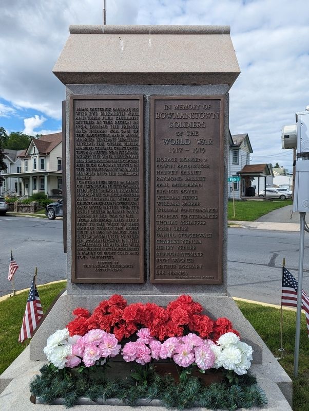
On White Street at East White Street, on the right when traveling west on White Street.
(Left side Plaque)
Hans Dieterick Bauman, his
wife Eve Elizabeth Weil,
and their four children
settled in this region in
1754, during the French
and Indian War. One of
the daughters, Anna Maria,
married Sergeant Sebastian
Seybert; . . . — — Map (db m247343) HM
On White Street at East White Street, on the right when traveling north on White Street.
Bowmanstown Borough
In honor
And
In memory of
Those who served in:
The Korean War
The Viet-Nam War
The Gulf War
(lower plaque)
This flagpole is dedicated
to those brave soldiers who put
their lives at risk to . . . — — Map (db m247297) WM
On White Street at East White Street, on the right when traveling north on White Street.
In Honor of the Veterans of
Bowmanstown
World War II 1941-1945
★ Heintzelman, Willard R.
• ★ Hermany, Charles w.
• Arner, Marian C.
• Balliet, Clair V.
• Balliet, Harold M.
• Balliet, Paul S.
• Balliet, William A. . . . — — Map (db m247407) WM
On White Street at East White Street, on the right when traveling west on White Street.
(Right Side Plaque)
In memory of
Bowmanstown
Soldiers
Of the
World War
1917-1919
• Horace Hongen ★
• Edwin Bagenstose
• Harvey Balliet
• Raymond Balliet
• Earl Beidleman
• Francis Boyer
• William Deppe
• . . . — — Map (db m247342) WM
On Packer Hill Avenue at Hazard Square, on the right when traveling west on Packer Hill Avenue.
After World War II, prosperity resided elsewhere. In Mauch Chunk and East Mauch Chunk too many remained unemployed. To raise money to lure factories to town, Joe Boyle helped organize the grass roots "Nickel-a-Week" campaign. He also hoped to . . . — — Map (db m252130) HM
On North Street (Pennsylvania Route 903) 0.1 miles north of 13th Street, on the left when traveling north.
"Our lives were lived in the open," he remembered, "winter and summer. We were never in the house when we could be out of it. And we played hard. I emphasize this because boys and girls who would grow up physically fit adults must lay . . . — — Map (db m116592) HM
On Center Avenue at Church Alley, on the left when traveling west on Center Avenue.
"A quarter of an hour's walk from the hotel up a very steep incline…brought me to…the Mauch Chunk and Summit Hill Railroad Depot."
"Special Correspondent, New York Times, December 14, 1872, p . . . — — Map (db m252159) HM
On East Catawissa Street (U.S. 209) at Susquehanna Street (U.S. 209) on East Catawissa Street.
This black diamond is a piece of the mammoth coal vein found in the Panther Valley. It was placed here on August 28, 1976 as a monument to the enterprising spirit of men such as Josiah White and Erskine Hazard, whose early pioneering efforts . . . — — Map (db m141004) HM
On Packer Hill Avenue at Hazard Square, on the right when traveling west on Packer Hill Avenue.
Readers of The Times News came to expect it. In every April 1 edition, among the paper's serious news, editor and reporter Joe Boyle planted a well researched practical joke. Clues to the verity of the facts often rested with key players in . . . — — Map (db m252128) HM
On Packer Hill Avenue west of Hazard Square, on the left when traveling north.
Asa Packer Mansion
has been designated a
National Historic Landmark
This property possesses national significance in commemorating the history of the United States of America
Built in 1860 for industrialist and philanthropist . . . — — Map (db m252156) HM
On Packer Hill Avenue north of Hazard Square, on the left when traveling north.
Asa Packer Mansion
has been designated a
National Historic Landmark
This property possesses national significance in commemorating the history of the United States of America
Built in 1860 for industrialist and philanthropist . . . — — Map (db m252158) HM
On South Avenue at Spruce Avenue, on the right when traveling east on South Avenue.
Born in Lockport, PA May 30th, 1832
Died in Germany, Oct. 30th, 1902 at the age of 70
He achieved recognition as an Educator, having instituted many reforms to the school systems in the South. He established his own Seminary in Baton Rouge, . . . — — Map (db m196444) HM
Formed March 13, 1843 from Northampton and Monroe counties. Carbon is the basic element of this area's rich deposits of anthracite coal. The county seat, incorporated in 1850 as Mauch Chunk, was renamed in 1954 for Jim Thorpe, Indian athlete. — — Map (db m32150) HM
On Liberty Road just south of East Catawissa Street (U.S. 209), on the left when traveling north.
This monument marks the site of the Northern Liberties, from this village of fifty families, fifty-six men enlisted for the defense of the Union in the War of 1861 -1865
Patrick Burns •
Daniel Burns •
John Burns •
John Billingsley . . . — — Map (db m252434) WM
Near Susquehanna Street (U.S. 209) 0.1 miles south of Race Street, on the left when traveling south.
"The problem of getting coal from wagon to ark was solved by constructing an inclined loading chute at Mauch Chunk that extended downward from Mount Pisgah to a coal-loading house along the Lehigh River. The coal house projected over the river's . . . — — Map (db m138499) HM
On Packer Hill Avenue at Hazard Square, on the right when traveling west on Packer Hill Avenue.
In a story about a fictional lake formed by a dam across the Mauch Chunk Creek, Boyle wrote, "the impounded body of water might be used as a major source of consumer supply," or used "as a lake area for the recreation and enjoyment of tourists . . . — — Map (db m252126) HM
Near Susquehanna Street (U.S. 209) 0.1 miles south of Race Street, on the left when traveling south.
"It should be borne in mind that in timber dams it is the weight of the stone ballast that keeps the structure in place, and not the bulk and combination of the timbers." Edwin F. Smith, Dam Building in Navigable and Other Streams . . . — — Map (db m138500) HM
Near Lehigh Avenue (U.S. 209) at Lehigh Gorge Trail.
“Our residents take pride and partner in their heritage — they understand the meaning of what we have and act to preserve it” Delaware & Lehigh National Heritage Corridor and State Heritage Park, Management Action Plan. . . . — — Map (db m153540) HM
On East Catawissa Street (U.S. 209) at Susquehanna Street (U.S. 209) on East Catawissa Street.
"A few miles above Easton, the Lehigh was pocked with white water at almost every turning. To navigate it seemed impossible."
Josiah White, Co-founder of the Lehigh Coal and Navigation Company
Near Lehigh Avenue (U.S. 209) at Lehigh Gorge Trail.
"Since most of the land was donated to the railroads by the American public in the first place, we believe it should be returned to the public." David Burwell, President, Rails-to-Trails Conservancy, 1988 A Well-Worn Path The path you . . . — — Map (db m153536) HM
On North Street (Pennsylvania Route 903) 0.1 miles north of 13th Street, on the left when traveling north.
1887 · Born May 22 on the Sac and Fox Reservation near Belmont, Oklahoma Territory.
1904 · Enters Carlisle Indian School in Pennsylvania, scene of his brilliant career in college football.
1911 · First Team All-American Football Team at . . . — — Map (db m116566) HM
On North Street (Pennsylvania Route 903) 0.1 miles north of 13th Street, on the left when traveling north.
"Sir, you are the greatest athlete in the world."
King Gustav V of Sweden
Born in Oklahoma Territory in 1888, Jim Thorpe was a member of the Sac and Fox tribe. Prophetically named Wa-tho-huck (Bright Path) by . . . — — Map (db m307779) HM
On North Street (Pennsylvania Route 903) 0.1 miles 13th Street, on the left when traveling north.
"Sir, you are the greatest athlete in the world"
King Gustav, Stockholm Sweden, 1912 Olympics
[Athletic engravings on mausoleum] . . . — — Map (db m116564) HM
On Packer Hill Avenue at Hazard Square, on the right when traveling west on Packer Hill Avenue.
It happened again and again, for over 60 years. It happened at high school athletic games, at meetings of the Lions, V.F.W., Rotary, Chamber of Commerce, Borough Council, and Y.M.C.A. For decades it happened in the Mauch Chunk Times News and . . . — — Map (db m116526) HM
On Packer Hill Avenue at Hazard Square, on the right when traveling west on Packer Hill Avenue.
"Reverend Msgr. John Chizmar of Immaculate Conception Catholic Church said it all … for all of us. 'Joe made a difference,' he eulogized. 'He saw a Need and took the initiative to fill it; he gave Encouragement through his journalistic . . . — — Map (db m252131) HM
On Lehigh Avenue (U.S. 209) south of North Street ( Route 903), on the right when traveling north.
"Nearly all [canal] boatmen kept going day and night, boats being so numerous that the canal seemed to be a solid mass of boats."
W.H. Gausler
Lehigh Canal Boat Operator (1840-1856)
On Hazard Square west of Packer Hill Avenue, in the median.
Those who made the supreme sacrifice
Anthony, Richard J. •
Corkill, John T. •
Crilley, Frank •
Crilley, Melvin J. •
Devenney, William J. •
Gyuricsek, Stephen •
Hilferty, Edward J. •
Hughes, David L. •
Johnes, Robert Lee • . . . — — Map (db m252422) WM
On Packer Hill Avenue at Hazard Square, on the right when traveling west on Packer Hill Avenue.
Citing tourism as an important tool in economic prosperity, Boyle's 1982 story announced plans to develop a mine museum in Lansford. "If this succeeds to the extent that we contemplate, it will mark the beginning of a new era of prosperity for . . . — — Map (db m252124) HM
On West Broadway at High Street, on the right when traveling west on West Broadway.
On June 21, 1877, four "Molly Maguires," an alleged secret society of Irish mine-workers, were hanged here. Pinkerton detective James McParlan’s testimony led to convictions for violent crimes against the coal industry, yet the facts of the labor, . . . — — Map (db m32153) HM
On Packer Hill Avenue at Hazard Square, on the right when traveling west on Packer Hill Avenue.
In a 1965 April Fool's Day story, Boyle predicted the production of a major motion picture about the secret Irish-American society, the Molly Maguires. Making use of the county court house, jail, and local residences, the film promised to . . . — — Map (db m252125) HM
Near Lehigh Avenue (U.S. 209) at Lehigh Gorge Trail.
”So far back as 1827, the Company constructed down-grades on which loaded cars were run down to the Lehigh River by their own gravity.” —“Special Correspondent, New York Times, December 14, 1872, p 3.” Geography . . . — — Map (db m153422) HM
On Broadway at East Catawissa Street (U.S. 209), on the left when traveling west on Broadway.
Standing on the nearby hill is the home of Asa Packer, industrialist, philanthropist, congressman and founder of Lehigh University. The ornate mansion, built in 1860, has been carefully preserved with its original furnishings and is maintained as a . . . — — Map (db m140827) HM
"In my humble opinion, the Aqueduct, or Race, which carries water over Susquehanna Street to the Mill...is a great nuisance. The water descends from it like a Shower bath...and no person..can pass under it without getting wet." — — Map (db m268159) HM
On North Street (Pennsylvania Route 903) south of West 6th Street, on the right when traveling north.
Pastors:
Father John Freude, 1871 •
Msgr. William Heinen, 1872 - 1910 •
Msgr. Peter J. Masson, 1910 - 1911 •
Father Joseph A. Assmann, 1911 - 1931 •
Father Jacob Wm. Post, 1931 - 1955 •
Father Francis P. Adolf, 1955 - 1968 •
Father . . . — — Map (db m252149) HM
On North Street (Pennsylvania Route 903) 0.1 miles north of 13th Street, on the left when traveling north.
Jim's dominance over his intercollegiate rivals in football was paralleled by his records as a member of the Carlisle track team. He ran sprints, he ran hurdles and he ran distance races. He high jumped and he broad jumped. He threw the . . . — — Map (db m116632) HM
On North Street (Pennsylvania Route 903) 0.1 miles north of 13th Street, on the left when traveling north.
The Indian wars were over and the Army had moved the Indians to forts and reservations. A young Army officer named Richard Henry Pratt had taken part in the Indian fighting and subsequent subjugation of the Indians. His observations had caused . . . — — Map (db m116601) HM
On Broadway at Hill Road, on the right when traveling west on Broadway.
This Italianate Victorian townhouse was the home of U.S. Congressman Milo M. Dimmick and his family. His son Milton founded the Dimmick Memorial Library in Old Mauch Chunk in their memory. — — Map (db m163184) HM
Near Susquehanna Street (U.S. 209) 0.1 miles south of Race Street, on the left when traveling south.
"The class that resort here are select, intelligent, of quiet, unostentatious manners, who mostly come here for health and to admire and study the wonders and beauties of nature..."
The Health and Pleasure-Seeker's Guide, 1874
By . . . — — Map (db m138507) HM
On North Street (Pennsylvania Route 903) 0.1 miles north of 13th Street, on the left when traveling north.
[Center inset quote reads]
"Sir, you are the greatest athlete in the world."
King Gustav V of Sweden
Legend has made a tragic figure of Jim Thorpe, blighted by his Olympic heartbreak, but in fact, after the initial . . . — — Map (db m116702) HM
On Packer Hill Road west of East Calawissa Street.
"…there is no distinction to which any young man may not aspier, and with energy, diligence, intelligence, and virtue, obtain."
From Asa Packer's 1867 biography
"The Rich Men of the World and How they Gained their . . . — — Map (db m32270) HM
Southern face:
To all the Brave Defenders of the Union from the County of Carbon.
Appomattox, 1865.
Northern face:
Wilderness, Hampton Roads, Antietam, Gettysburg
New Orleans, 1815.
Eastern face:
On . . . — — Map (db m32102) WM
This house (1844 A.D.) is the oldest complete and unchanged home existing from the early history of Mauch Chunk (now Jim Thorpe). Built as a parsonage by the Rev. Webster, famous pastor of the Presbyterian church, the home was certified as oldest . . . — — Map (db m128303) HM
On West Broadway just west of Hill Road, on the left when traveling east.
1853 Organized Marion hose Co. First fire company in the county. Disbands 1856.
1866 Reestablished & purchases old US hose carriage no 14 from Philadelphia.
1875 Purchases Silsby steam engine for $4000.
1883 . . . — — Map (db m252144) HM
On West Broadway west of Hill Road, on the left when traveling east.
1881
Designed by prominent Quaker architect, Addison Hutton. The new venue initially featured a concert hall, seating over 900 on the 2nd floor & a farmer's market on the first floor. The Concert Hall was a regular stop on the vaudeville . . . — — Map (db m252132) HM
"As soon as the passenger-car arrived at the bottom of the plane, the safety-car....came up behind it, and drawn up the plane by two broad iron bands working over a steam powered driven drum at the top, propelled the passenger car before . . . — — Map (db m268161) HM
On Packer Hill Avenue at Hazard Square, on the right when traveling west on Packer Hill Avenue.
In 1984, Lehighton's "long and storied past as a railroad center" prompted Boyle to create an April Fool's tale that included not only a rail museum but also train excursions, a dining car restaurant, and a motel of cabooses. Destined to be a . . . — — Map (db m252123) HM
On Packer Hill Avenue north of Hazard Square, on the left when traveling north.
"I mention these circumstances as an encouragement of what may be accomplished by a life of integrity, energy and devotion to business."
Matthew S. Henry, 1860, History of the Lehigh Valley
On East 10th Street east of Fern Street, on the right when traveling east.
In grateful memory of those from this community who so faithfully served in the World War.
Mauch Chunk-East Mauch Chunk World War I Honor Roll
Albeck, George A. •
Allan, George •
Allen, . . . — — Map (db m252430) WM
On North Street (Pennsylvania Route 903) at 9th Street, on the right when traveling north on North Street.
Dedicated to the memory
of those who made
the supreme sacrifice
World War II
PVT. Joseph T. Martino • CPL. Fred Felker
PFC. James Lauth • PVT. Patrick Searfoss
PFC. Anthony Fabrick Jr. • S/SGT. Maurice Pricka
T/S. . . . — — Map (db m116522) WM
Near Lehigh Gorge Trail 10.1 miles south of Rockport Trailhead, on the left when traveling south.
How a Lock Works
1. Upper valves are opened and water in lock is raised to level of upstream canal. Upper gate is lowered and boat enters lock. Upper gate is closed.
2. Valves in lower gates are opened, allowing water to empty . . . — — Map (db m196407) HM
On Lehigh Gorge Trail 1.7 miles west of Main Street, on the right when traveling north.
“Our residents take pride and partner in their heritage — they understand the meaning of what we have and act to preserve it” Delaware & Lehigh National Heritage Corridor and State Heritage Park, Management Action Plan. . . . — — Map (db m153538) HM
On Lehigh Gorge Trail 1.7 miles west of Main Street, on the right when traveling north.
Welcome to Lehigh Gorge State Park. This 4,548-acre park stretches 32 miles along the Lehigh River from the Francis E. Walter Dam in the north to Jim Thorpe in the south. Carved by the power of the Lehigh River, the park's deep gorge, steep . . . — — Map (db m153550) HM
On Lehigh Gorge Trail 4 miles north of Main Street.
”My grandfather, Samuel Rice got a job as a watchman after the pipeline was built in 1886. In an emergency he could turn off the valve at either end of the bridge from his house. My mother, Ethel Rice Jenkins, tells how the house was in the . . . — — Map (db m153420) HM
Near Lehigh Gorge Trail 2.2 miles west of Main Street when traveling north.
"Built in 1850, the (inclined) planes were 1,200 feet long and 430 feet high. As a loaded car descended on one plane. it would draw an empty car up the other plane."
John Koehler, Railroad Historian, Weatherly
You are . . . — — Map (db m114632) HM
On Lehigh Gorge Trail 1.7 miles west of Main Street, on the right when traveling north.
“We had been in many beautiful glens, but this was so unlike all others, so varied — grand and noble falls alternating with delightful rippling cascades, lovely moss covered grottos, marvelous combination — that we were led to exclaim ‘All hail, . . . — — Map (db m153421) HM
On Pennsylvania Route 903 0.3 miles south of Reservoir Road, on the right when traveling north.
The residents of Penn Forest Township thank all the men and women in the Armed Forces who sacrificed so much for us to have the freedoms we have today
Thank you — — Map (db m252160) WM
On Sgt Stanley Hoffman Boulevard (U.S. 209) 0.2 miles north of South Main Lane, on the right when traveling north.
In honor of all
Veterans of the
United States
Navy
☆☆☆☆
Marine Corps
☆☆☆☆
Coast Guard
☆☆☆☆
Merchant Marines
From The
Lehighton, PA Area
Anchors . . . — — Map (db m116268) WM
On 1st Street at North Main Lane/South Street, on the right when traveling south on 1st Street.
"Lehighton is a very beautiful and most pleasant town."
Georg Heinrich Loskiel
Moravian bishop and historian
Anthracite Pioneer
Philadelphia-born Col. Jacob Weiss (1750-1839) was deputy quartermaster general of . . . — — Map (db m116387) HM
On Sgt Stanley Hoffman Boulevard (U.S. 209) north of North Main Lane, on the right when traveling north.
“Our residents take pride and partner in their heritage—they understand the meaning of what we have and act to preserve it”
Delaware & Lehigh National Heritage Corridor and State Heritage Park, Management Action . . . — — Map (db m116343) HM
On Sgt Stanley Hoffman Boulevard (U.S. 209) at North Main Lane, on the right when traveling north on Sgt Stanley Hoffman Boulevard.
"Since most of the land was donated to the railroads by the American public in the first place, we believe it should be returned to the public."
David Burwell, President,
Rails-to-Trails Conservancy, 1988
A Well-Worn . . . — — Map (db m116342) HM
On East Penn Street 0.1 miles north of Blakeslee Boulevard, on the left when traveling north.
Gnadenhuetten. The Moravian mission of this name was built in 1746 to accommodate the growing number of Mohican and Delaware Indian converts. It was the first white settlement in present-day Carbon County. It was burned on November 24, 1755, during . . . — — Map (db m133878) HM
On Sgt Stanley Hoffman Boulevard (U.S. 209) 0.2 miles north of South Main Lane, on the right when traveling north.
Sgt. Stanley Hoffman
1919 - 1944
For whom this boulevard was named,
paid the supreme sacrifice in the line of duty,
during the invasion of Anzio Beach, Italy.....
This monument is a memorial to all fifty-seven
servicemen, from the . . . — — Map (db m116324) WM
On Iron Street at South 8th Street, on the right when traveling east on Iron Street.
"The truly spectacular feature of the Carbon County Fair… was the airport. Jake Arner's big hanger stood at the southern end of the midway, and during fair week local private pilots were available to take all comers who could pay . . . — — Map (db m252105) HM
On Sgt Stanley Hoffman Boulevard (U.S. 209) north of North Main Lane, on the right when traveling north.
"The first workers' whistle [at Packerton Yard] sounded at 5 a.m. as a wakeup call while the second at 7 a.m. was the signal for the men to start work."
Thomas D. Eckhart
The History of Carbon County, v. III
When the . . . — — Map (db m116344) HM
On South 4th Street at Bridge Street, on the right when traveling north on South 4th Street.
This was the first settlement in Carbon County, founded in 1746. On that fatal day in 1755, the settlement was attacked by hostile Indians. 10 people lost their lives, 5 of which died in the flames of their home.
Their remains are . . . — — Map (db m252108) HM
On 3rd Street at North Street, on the left when traveling north on 3rd Street.
Dedicated
to
All Who
Served
—————————
Designed & Hand Painted
Original & Replacement Cross
2012 • 2014
By Dotti Miller
Class of 1965
Original Cross Made By
Mark "Irish" Hagan . . . — — Map (db m116398) WM
On 3rd Street at North Street, on the left when traveling north on 3rd Street.
In Memory of Class of 1964 member
PFC Clyde R. (Speedy) Houser KIA June 13, 1967
and Lehighton Area Residents
SP4 Leon D. Eckhart KIA Feb. 25, 1967
LCPL Ronald S. H. (Butch) Christman KIA Feb. 28, 1968
SP4 Charles R. (Butch) Jones KIA . . . — — Map (db m116401) WM
Dedicated to all those who served
during the Vietnam War
Those who paid the supreme sacrifice
Leon D. Eckhart • Clyde R. Houser, Jr. • Ronald S.H. Christman • Charles R. Jones • Merlin C. Hollenbach
POW ☆ . . . — — Map (db m252117) WM
On Sgt Stanley Hoffman Boulevard (U.S. 209) 0.2 miles north of South Main Lane, on the right when traveling north.
This memorial is dedicated to Michael C. Wargo, and the brave men and women whom have fought for America overseas, and have paid the final price here at home due to PTSD or TBI. We cannot stand idly by as Veteran suicides sweep the country. This . . . — — Map (db m116320) WM
On Water Street at Centre Street, on the right when traveling east on Water Street.
Growing up in Parryville, Carl learned valuable life lessons by playing. In high school, he was the javelin state champion; at Penn State he became an All-American in Track & Field and is the record holder for javelin in the college Big Ten . . . — — Map (db m124041) HM
On Main Street at Chestnut Street, on the right when traveling north on Main Street.
This memorial
erected and dedicated
in honor of the Boys of
Parryville
who served in the World War.
—————————
Russel Smith • Raymond McClellan☆
Gerald Eshleman • Raymond . . . — — Map (db m124039) WM
On Pine Street at East Ludlow Street, on the right when traveling north on Pine Street.
At the corner of Pine and Ludlow, an important part of the Switchback Gravity Railroad was completed around 1844. Upon returning from Mauch Chunk, empty mine cars began their Summit Hill descent east of town at the Mount Jefferson Plane. Passing . . . — — Map (db m128304) HM
Near East White Bear Drive 3 miles east of Route 902, on the left when traveling east.
”Leaving Mt. Pisgah, the weight of the car was again its motive power, and the slight decline in the grade carried it at the speed of eighteen miles an hour to Mt. Jefferson, a distance of six miles and one furlong…”
. . . — — Map (db m125628) HM
Deeded to the Presbyterian Church in 1850 by the Lehigh Coal and Navigation Company, this is the last resting-place for many of Panther Valley’s earliest settlers. Originally lined with individual tombstones, graves were enclosed with iron fences . . . — — Map (db m86826) HM
On West Ludlow Street at North Market Street on West Ludlow Street.
While hunting, Ginter discovered anthracite on Sharp Mountain here in 1791. He showed it to Col. Jacob Weiss, a prominent area settler. In 1792 Weiss and others formed the Lehigh Coal Mine Co., the first Anthracite company and a forerunner of Lehigh . . . — — Map (db m86828) HM
A gravity railroad was built along this mountain in 1827 to carry coal from the mines near Summit Hill to the Lehigh Canal at Mauch Chunk. A back-track and two planes were added in 1844 for the return trip by gravity. Railroad crossed the highway . . . — — Map (db m125636) HM
Near Rockport Road 1 mile east of South Lehigh Gorge Drive.
How a Lock Works 1. Upper valves are opened and water in lock is raised to level of upstream canal. Upper gate is lowered and boat enters lock. Upper gate is closed. 2. Valves in lower gates are opened, allowing water to empty from . . . — — Map (db m153402) HM
Near Rockport Road 1 mile east of South Lehigh Gorge Drive.
”This is one of the worst wrecks ever in the country, because you had wooden cars. They were prone to 'telescoping,' or collapsing when they were hit from behind by an 'iron horse.'” —John Koehler Railroad Historian, Weatherly Mud Run is the . . . — — Map (db m153401) HM
Eckley Miners’ Village opened in 1854 as anthracite coal-mining became the predominant regional industry. Homes and a company store were first established. A colliery (breaker), additional houses, churches, hotel, school and outbuildings erected in . . . — — Map (db m89684) HM
482 entries matched your criteria. The first 100 are listed above. Next 100 ⊳