Kansas City - Native Sons and Daughters of Greater Kansas City Historical Markers
More than 100 historic markers that signify events and locations highlighting the political, military, social, and economic history of greater Kansas City.
On Metcalf Avenue south of 87th Street, on the right when traveling south.
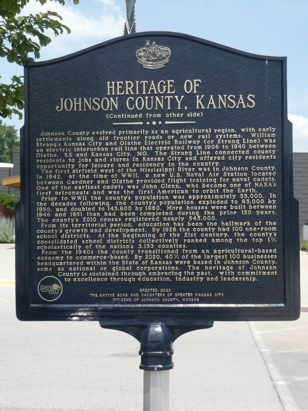
The heritage of Johnson County, Kansas extends back to the native peoples who occupied this land prior to European exploration and settlement. In the 1700s, French explorers, trappers and traders engaged with the Kansa and Osage natives of this . . . — — Map (db m226610) HM
On West 79th Street at Santa Fe Drive, on the right when traveling west on West 79th Street.
Constructed in 1906, this building served
the Missouri-Kansas Interurban Railway as a
power plant and a repair station. Founded
by William B. Strang, the railway transported
passengers between downtown Kansas City,
Missouri and Olathe, Kansas, . . . — — Map (db m251949) HM
Lewis and Clark at Kaw Point
The Lewis and Clark expedition arrived here at Kaw Point on June 26, 1804, concluding another daily struggle against the powerful current of the Missouri River. Captain William Clark wrote in his journal that . . . — — Map (db m53939) HM
Built by Moses R. Grinter in 1857 on the then Delaware Indian Reserve, this house was near the point where in 1831 he had begun operation of the first ferry on the Kansas River. For many years following its survey in 1837 the Fort Leavenworth - . . . — — Map (db m46338) HM
On Northwest Old Pike Road at Northwest 51st Street, on the right when traveling south on Northwest Old Pike Road.
Old Pike Road is the oldest, most westerly, north-south road in Clay County. Starting at Kawsmouth on the north bank of the Missouri River in Harlem it ran north, skirting on the east an old river scar the settlers called “the slough bank,” until it . . . — — Map (db m252107) HM
On NE Antioch Road (Missouri Route 1) at NE 48th Street, on the right when traveling north on NE Antioch Road.
"The Antioch Congregation was organized as a Christain Church (Disciples of Christ) in September 1853 by Moses Easterly Lard (1818-1880), Pastor of the Liberty Christain [sic] Church in Missouri. Its first 'Meeting House', a one room building, and . . . — — Map (db m86636) HM
On Miller Avenue at William Jewell College Drive, on the right when traveling west on Miller Avenue.
On July 5th, 1836, Andrew Hixon and wife, Ann, conveyed by Warranty Deed to the "Town of Liberty" Trustees for $30, one acre, "for the purpose of a public burying ground". Used as such before the 1825 settlement of Liberty. "The Old Graveyard", . . . — — Map (db m68263) HM
Near Vine Street north of 18th Street, on the right when traveling north.
The American Jazz Museum is an important cultural institution dedicated to its mission of celebrating and exhibiting jazz through performance, education, exhibitions and research at America's Jazz Crossroads - 18th and Vine.
There were four . . . — — Map (db m98414) HM
On Vine Street north of 18th Street, on the right when traveling north.
The Negro Leagues Baseball Museum (NLBM), located in Kansas City's historic 18th & Vine Jazz District, is dedicated to preserve the rich history of professional African-American baseball of the early 1900s to the 1950s and its profound impact on . . . — — Map (db m98412) HM
On Harrison Parkway east of Locust Street, on the left when traveling east.
The Boy Scouts of America (BSA) was founded in 1910 and was inspired
by and modeled after a program established by Baden-Powell in Britain
in 1908. The Scouting movement is designed to inspire youth through
programs with connections to nature, . . . — — Map (db m251997) HM
On Gillham Road at 36th Street, on the left when traveling south on Gillham Road.
Play began on the Kenwood Golf Links, an extension of the Hyde Park Country Club, in 1894. A group composed mostly of transplanted Scots laid out nine holes between 36th and 38th Streets, Gillham (Oak) to Charlotte, with the ninth green in the yard . . . — — Map (db m67795) HM
On Brookside Boulevard at 55th Street, on the right when traveling north on Brookside Boulevard.
This plaque is placed here in honor of James Gailey Ashley, Jr. and his wife, Pamela C. Ashley, who for 25 years struggled and sacrificed to preserve this railroad right-of-way, which provided freight and passenger service beginning in the . . . — — Map (db m69375) HM
On Cherry Street south of East 52nd Street, on the left when traveling south.
Organized on September 14, 1917, under the direction
of Carolyn Farwell Fuller, who conceived the idea of
establishing a club for the advancement of the charitable,
social and educational interests of married women. This
Colonial Revival style . . . — — Map (db m251964) HM
On 13th Street 0.1 miles east of Central Avenue, on the right when traveling west.
Kansas City’s expression of service and hospitality has a rich historical heritage starting in 1899, when the original convention hall opened with a concert by John Philip Sousa and his band. The success of the hall was proven when the Democratic . . . — — Map (db m86215) HM
Famous Painter & Portrait Artist
Internationally Known
State Treasurer
State Adjutant General
President, Kansas City, Mo. Police Board
——————————
Eminently gifted, almost . . . — — Map (db m62974) HM
On W 14th Street, on the right when traveling north.
Organized in 1949 to investigate corruption, the Commission has become a model for ways to organize the struggle for greater public safety. At its inception, Kansas City Businessman and civic leader E.M. Dodds pushed for the Commission to cut down . . . — — Map (db m134079) HM
On Arena Drive at American Royal Drive, on the right when traveling west on Arena Drive.
Opening as the Kansas Stockyards Company on June 1, 1871, it soon was renamed and reorganized as a bi-state Kansas City Stock Yards Company, growing to 13 acres by 1878. Built by enterprising railroad officials such as C.V. Morris and stock traders, . . . — — Map (db m199289) HM
On East 19th Street at Tracy Avenue, on the right when traveling west on East 19th Street.
Richard Thomas Coles
(educator)
Located here at 1835 Tracy, the R.T. Coles Vocational and Junior High School opened in 1936 in the building formerly occupied by Lincoln School. The school was named for Richard Thomas Coles in . . . — — Map (db m200145) HM
On East 13th Street at Holmes Street, on the left when traveling west on East 13th Street.
Founded in 1857 as St. Luke's and
located at 8th and Walnut. Under the
influence of The Oxford Movement
patronage was transferred to Our
Lady in 1879. Ground for this Gothic
structure was broken in 1886 and
completed two years later. . . . — — Map (db m252034) HM
On American Royal Court, on the right when traveling east.
The roots of the American Royal stem from the National Hereford Show in the fall of 1899, held in a tent in the Kansas City Stockyards. The American Royal was the first nationwide show for the exposition and sale of purebred cattle, having an . . . — — Map (db m199287) HM
On Cemetery Road at Warwick Trafficway, on the left when traveling east on Cemetery Road.
(Left Side)The Cemetery The Union Cemetery was incorporated by the State of Missouri November 9, 1857 and the first interment was made in 1858. Many of the graves have been removed from earlier burying grounds whose capacities had been . . . — — Map (db m19941) HM
On Walnut Street north of East 12th Street, on the right when traveling north.
The Greater Kansas City Restaurant Association (GKCRA) was established in 1916, when three visionary restaurateurs, Myron Green, George Fowler, and Guy Taylor began meeting in the basement of Myron Green's Cafeteria on this site at 1115 Walnut. In . . . — — Map (db m252036) HM
On Grand Boulevard at Truman Road North Drive, on the right when traveling north on Grand Boulevard.
Very near here at 1425 Grand Avenue during The Civil War, a tragedy occurred that was to intensify the ferocious hatred of the Border guerrillas for the Union forces. Under Union General Ewing's orders, the guerrillas' women were imprisoned in a . . . — — Map (db m42056) HM
On West Pershing Road at Main Street, on the right when traveling west on West Pershing Road.
Following the flood of 1903, Kansas City's original Union Depot, located in Kansas City's west bottoms, was rebuilt on this site in 1914 as Union Station and heralded as one of the most beautiful train stations, and the third largest passenger . . . — — Map (db m198768) HM
On Chiefs Way at Red Coat Lane, on the right on Chiefs Way.
The Jackson County Sports Complex Authority was established in 1967 as a political subdivision of the State of Missouri to serve as the landlord between Jackson County and the Kansas City Royals and the Kansas City Chiefs. Construction began in the . . . — — Map (db m118948) HM
On Tenth Street 0.1 miles west of Central Avenue, on the right when traveling east.
In June – July, 1861, barracks and service buildings within a 200-foot-square earthwork were built on this site by the battalion of United States Reserve Corps, Companies A, B, and C, organized by Major R. T. Van Horn, then Mayor of the City. By . . . — — Map (db m51192) HM
On Central Street at 9th Street, on the right when traveling north on Central Street.
The Savoy Hotel was constructed between 1890 and 1906 during a building boom which created some of the most architecturally significant buildings in the central business district. The first major hotel enroute from the old Union depot, it served as . . . — — Map (db m19831) HM
On Baltimore Avenue at West 40th Street, on the right when traveling south on Baltimore Avenue.
Built in 1855 by John and Henrietta Harris this Greek revival style all brick house was located on a slightly five acre tract on the ridge just east of Westport, MO. This site was on the southwest corner of Westport Rd. (Santa Fe Trail) and Main . . . — — Map (db m44411) HM
On Pennsylvania Avenue at Westport Road on Pennsylvania Avenue.
(Main Marker)
Originally used as an outfitting store for wagon trains, this building was completed in 1850 by Indian traders George and William Ewing and was sold in 1854 to Albert Gallatin Boone for $7,000. Boone operated the store . . . — — Map (db m20921) HM
On 3rd Street at Main Street, on the right when traveling east on 3rd Street.
From 1857 to the present, town activities have revolved around the "City Market", an integral site for commerce, political rallies, medicine shows, circuses, balloon ascensions, and other public "entertainments" without limits. Its origin began . . . — — Map (db m58410) HM
On West 49th Street at Main Street, on the right when traveling west on West 49th Street.
From 1966 to 2013 this building was home of the Kansas City Board
of Trade. Here the world price of wheat was determined as supply and
demand met in its trading pit. Traders shouted orders to buy or sell
futures contracts for the owners and . . . — — Map (db m251966) HM
On Sunset Drive at 51st Street, in the median on Sunset Drive.
Here just before noon on Sunday, October 23, 1864, Major General Samuel Ryan Curtis, commanding the Federal Army of the Border, began his flanking movement of Brigadier General Joseph Orville Shelby's Division of the Confederate Army of Missouri. . . . — — Map (db m21702) HM
In 1896, two years after introducing golf to Kansas City at the Kenwood Golf Links east of Gilham and south of 36th Street, devotees of the game sought larger space here, at Seth Ward's east pasture. A $1-a-year lease was signed, and a nine-hole . . . — — Map (db m88252) HM
On Ward Parkway east of Sunset Drive, on the right when traveling east.
Up the long hill to the south,
now Wornall Road, rolled the Santa
Fe Trail. Out of Westport, Missouri in
the 1840s and 50s came hundreds of
men, oxen, horses, mules, and wagons
loaded with trade goods, heading
for Santa Fe, New Mexico. By
the . . . — — Map (db m251994) HM
On Starlight Road at Pavilion Road, on the left when traveling east on Starlight Road.
As the City of Kansas City celebrated the U.S. Bicentennial in 1976, Mayor Charles B. Wheeler, focusing on Kansas City's rich cultural roots, formed the Ethnic Heritage Committee. The Committee planned an ethnic Bicentennial Parade, presented . . . — — Map (db m251950) HM
On Swope Parkway 0.2 miles east of Meyer Boulevard.
Immediately east of the Shelter House, nine holes laid out by James Dalgleish, professional at the nearby Evanston Golf Club, were opened September 5, 1906. An exhibition match featuring Dalgleish and the other two local professionals drew a small, . . . — — Map (db m30301) HM
On Manchester Trafficway 0.2 miles north of East 63rd Street, on the right when traveling east.
At 8 A. M. on October 23, 1864, Federal cavalry under General Alfred E. Pleasonton forced a crossing of the Blue River at Byram’s Ford and attacked the stone ridge, which was defended by Confederate troops under John S. Marmaduke. After 3 hours . . . — — Map (db m28705) HM
On Pennsylvania Ave. at 33rd Steet, on the left when traveling west on Pennsylvania Ave..
Built in 1901 by Irish immigrants, Edward and Mary Flavin to continue their established Flavin Grocery. The upper loft was their residence. In 1917, the grocery passed to their daughter and son-in-law Margaret & James M. (Jim) Browne, Sr. The name . . . — — Map (db m86245) HM
On Vine Street at East 21st Street, on the right when traveling north on Vine Street.
In 1890 Fire Chief George C. Hale was authorized by the City of Kansas
City to form a new Hose Co. No. 11, as the first all-black fire company
for the Kansas City Fire Department (KCFD). Having been hired by KCFD
in 1887 as its first black . . . — — Map (db m252032) HM
On Osage Street, on the right when traveling north.
On June 23-24, 1804 the Corps of Volunteers for Northwestern Discovery spent Saturday afternoon, the night and early Sunday morning across the river from the bluffs which would, in four years time, become the site of Fort Osage. On September . . . — — Map (db m86560) HM
Near Osage Street just north of 3rd Street, on the right when traveling north.
The native sons of Kansas City, Missouri organized and supervised the historical aspects of this project. Restoration was started in 1941 and completed in 1962. — — Map (db m144473) HM
On Main Street at 1st Street, on the right when traveling west on Main Street.
Here in 1839, with the "Platte Purchase", some of many settlers from Kentucky joined to establish Platte City; one, an Attorney, Merchant, Farmer, Mill Operator, Abstractor, Banker, Public Administrator, Genealogist, Historian, Poet and Civic . . . — — Map (db m63521) HM