52 entries match your criteria.
Entries Containing All of the Phrases «montgomery county» AND «ohio»
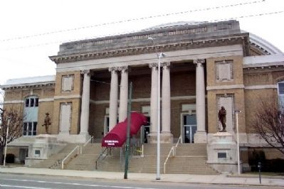
By William Fischer, Jr., February 14, 2009
Memorial Hall
RANKED BY RELEVANCE
1 ► Ohio, Montgomery County, Dayton, Downtown — Congressional Medal of Honor Recipients — State of Ohio, Montgomery County —  |
| On East 1st Street (State Highway 4) at North St. Clair Street, on the right when traveling west on East 1st Street. | |||
| 2 ► Ohio, Montgomery County, Kettering — 6-57 — Watervliet Shaker Community — |
| On Research Boulevard/County Line Road (Ohio Route 835) 0.1 miles north of Shakertown Road, on the left when traveling north. | |||
| 3 ► Ohio, Montgomery County, Dayton, DeWeese — 9-57 — Site of First Game in the NFL — |
| Near Ridge Avenue. | |||
| 4 ► Ohio, Montgomery County, Centerville — 11-57 — Brigadier General Edmund Munger — |
| On Yankee Street, on the left when traveling north. | |||
| 5 ► Maryland, Montgomery County, Rockville — Rockville — County Seat of Montgomery (formerly part of Frederick) County — |
| On South Washington Street at West Jefferson Street (Maryland Route 28), on the left when traveling north on South Washington Street. | |||
| 6 ► Ohio, Shelby County, Anna — John W. Carey — Founder of Anna, Ohio — |
| On Main Street (Ohio Route 119), on the left when traveling west. | |||
| 7 ► Ohio, Montgomery County, Vandalia — Cpl. John B. Buckmaster — |
| On Old Springfield Road at North Dixie Drive, on the right when traveling east on Old Springfield Road. | |||
| 8 ► Ohio, Montgomery County, Kettering — David's Cemetery - Established in 1826 — |
| On Mad River Road at Young Drive, on the right when traveling north on Mad River Road. | |||
| 9 ► Maryland, Montgomery County, Derwood — Newmantown |
| Near Rock Creek Park Road 0.6 miles north of Muncaster Road, on the left when traveling north. Reported permanently removed. | |||
| 10 ► Ohio, Montgomery County, Vandalia — Taylorsville Metropark - Metroparks Park System — |
| On South Cassel Road at East National Road (U.S. 40), on the right when traveling north on South Cassel Road. | |||
| 11 ► Maryland, Montgomery County, Poolesville — The Old Bank Building — |
| Near Fisher Avenue. | |||
| 12 ► Maryland, Montgomery County, Sandy Spring — Woodlawn — |
| On Park Police / Woodlawn Drive, on the right when traveling north. | |||
| 13 ► Maryland, Montgomery County, Silver Spring, Downtown Silver Spring — Spirited Entertainment — West Side Development — Silver Spring Heritage - Georgia Avenue — |
| On Georgia Avenue (U.S. 29) south of Bonifant Street when traveling south. | |||
| 14 ► Virginia, Bedford County, Montvale — K-121 — Colonial Fort — |
| On West Lynchburg Salem Turnpike (U.S. 460) 0.3 miles west of Circle K Road (Virginia Route 751), in the median. | |||
| 15 ► Maryland, Montgomery County, Silver Spring, Downtown Silver Spring — 24-Hour Service — Switching Places — Silver Spring Georgia Avenue Heritage Trail — |
| On Georgia Avenue (U.S. 97) at Cameron Street, on the right when traveling south on Georgia Avenue. | |||
| 16 ► Maryland, Montgomery County, Darnestown — Darnestown — Confederate Visit — Gettysburg Campaign — |
| On Darnestown Road (Maryland Route 28) 0.4 miles west of Seneca Road ( Route 112), on the right when traveling west. | |||
| 17 ► Maryland, Montgomery County, Silver Spring, Downtown Silver Spring — A Downtown is Born — Local Institutions — Silver Heritage Georgia Avenue — |
| On Georgia Avenue (Maryland Route 97) at Sligo Avenue, on the right when traveling north on Georgia Avenue. | |||
| 18 ► Ohio, Darke County, Versailles — Original Plat of Jacksonville — |
| On North 2nd Street at East Main Street (State Route 47), on the right when traveling south on North 2nd Street. | |||
| 19 ► Ohio, Montgomery County, Dayton, McCook Field — 28-57 — Katharine Kennedy Brown — |
| Near Webster Street at North Keowee Street. | |||
| 20 ► Maryland, Montgomery County, Bethesda — The Georgetown Branch Railroad — |
| Near Bethesda Avenue at Woodmont Avenue, on the right when traveling east. | |||
| 21 ► Maryland, Montgomery County, Bethesda — The Georgetown Branch Railroad — |
| Near Capital Crescent Trail 1.9 miles south of River Road ( Route 190), on the left when traveling south. | |||
| 22 ► Ohio, Greene County, Wright-Patterson Airforce Base — Huffman MetroPark — Five Rivers MetroPark — |
| On Lower Valley Pike at Ohio Route 4, on the right when traveling east on Lower Valley Pike. | |||
| 23 ► Texas, Montgomery County, Montgomery — 7906 — John M. Wade — (1815-1879) — |
| On Eva Street (State Highway 105) at Pond Street, on the right when traveling west on Eva Street. | |||
| 24 ► Maryland, Montgomery County, Gaithersburg — The Early Years — |
| Near South Summit Avenue just south of East Diamond Avenue, on the right when traveling north. | |||
| 25 ► Maryland, Montgomery County, Rockville — 7 — Montgomery County Court House — Location: Courthouse Square — Explore Early Rockville Walking Tour — |
| On Courthouse Square just west of Maryland Avenue, on the right when traveling east. | |||
| 26 ► Maryland, Montgomery County, Seneca — Rowser’s Ford — 5,000 Confederate Cavalrymen Crossed — Gettysburg Campaign — |
| On Rileys Lock Road south of River Road, on the right when traveling south. | |||
| 27 ► Maryland, Montgomery County, Silver Spring, Downtown Silver Spring — A Community Grows — Wayne Avenue Landmarks — Silver Heritage Georgia Avenue — |
| On Georgia Avenue (Maryland Route 97) at Wayne Avenue, on the right when traveling north on Georgia Avenue. | |||
| 28 ► Maryland, Montgomery County, Silver Spring, Downtown Silver Spring — Canada Dry Building — |
| Near East-West Highway near 1201 East-West Highway ( Route 410). | |||
| 29 ► Ohio, Montgomery County, Dayton — DAR Veterans Memorial — Woodland Cemetery — |
| On Civil War Road at Lookout Road, on the right when traveling west on Civil War Road. | |||
| 30 ► District of Columbia, Washington, Northwest Washington, Chevy Chase — Exploring Our Neighborhood: Black Broad Branch & Belmont — |
| On Wisconsin Avenue Northwest north of Harrison Street Northwest, on the right when traveling south. | |||
| 31 ► Kentucky, Menifee County, Wellington — 189 — Murder Branch Massacre — |
| On Old Beaver Road (Route 1274) at Big Woods Road, on the right when traveling west on Old Beaver Road. | |||
| 32 ► Maryland, Montgomery County, Darnestown — The Origins of Darnestown — Darnestown — |
| Near Darnestown Road (Route 28) just east of Seneca Road (Route 112), on the left when traveling east. | |||
| 33 ► Maryland, Montgomery County, Gaithersburg — The Woodlands — |
| Near Seneca Creek Road at Clopper Road ( Route 117), on the right when traveling west. | |||
| 34 ► Maryland, Montgomery County, Kensington — Baltimore and Ohio Railroad Bridge Abutment — |
| Near Beach Drive 0.3 miles north of Knowles Avenue ( Route 547), on the right when traveling north. | |||
| 35 ► Maryland, Montgomery County, Silver Spring, Downtown Silver Spring — The Hub of Growth — B&O Train Station — |
| On Georgia Avenue. | |||
| 36 ► Maryland, Montgomery County, Takoma Park — The Metropolitan Branch & Takoma Park — |
| On Takoma Avenue just south of Albany Avenue, on the right when traveling south. | |||
| 37 ► Maryland, Montgomery County, Takoma Park — The Metropolitan Branch and Takoma Park |
| On Takoma Avenue just south of Albany Avenue, on the right when traveling south. Reported permanently removed. | |||
| 38 ► Ohio, Montgomery County, Dayton — Montgomery County Revolutionary War Veterans Memorial — |
| On Civil War Road north of Lookout Road, on the left when traveling north. | |||
| 39 ► Ohio, Montgomery County, Dayton, University Park — William Morris House — |
| Near Carillon Blvd east of Arbor Boulevard. | |||
| 40 ► Ohio, Montgomery County, Englewood, Butler Township — Englewood Metropark - Metroparks Park System — You Are At East Park 4361 W. National Rd., Vandalia Welcome To Englewood Metropark — |
| On West National Road (U.S. 40) west of Patty's Road, on the right when traveling west. | |||
| 41 ► Georgia, Gordon County, Resaca — Site of Action — Judah's Division — |
| Near Resaca Lafayette Road Northwest (Georgia Route 136). | |||
| 42 ► Maryland, Montgomery County, Darnestown — Darnestown: A Strategic Point of Defense — The Civil War — |
| Near Darnestown Road (Maryland Route 28) at Seneca Road (Route 112), on the right when traveling west. | |||
| 43 ► Maryland, Montgomery County, Dickerson — White’s Ferry — Invasion or Liberation? — Antietam Campaign 1862 — |
| Near Whites Ferry Road 0.1 miles south of River Road, on the right when traveling west. | |||
| 44 ► Maryland, Montgomery County, Sandy Spring — Eliza Howard and Descendants / Remembering the Bells, Hopkins, Harriday Families — Sandy Spring African American Heritage Trail — [Sandy Spring Slave Museum & African Art Gallery] — |
| On Brooke Road 0.1 miles west of Chandlee Mill Road, on the right when traveling west. | |||
| 45 ► Maryland, Montgomery County, Sandy Spring — Mysteries of the Hopkins House / Free Black Slaves Settled the Norbeck Community — Sandy Spring African American Heritage Trail — [Sandy Spring Slave Museum & African Art Gallery] — |
| On Brooke Road 0.1 miles west of Chandlee Mill Road, on the right when traveling west. | |||
| 46 ► Ohio, Montgomery County, Dayton, University Park — Gristmill — |
| Near Carillon Boulevard 0.3 miles west of South Patterson Boulevard, on the left when traveling west. | |||
| 47 ► Tennessee, Montgomery County, Clarksville — First Courthouse Established ... Tennessee Awaits Statehood — 1796-1811 — |
| Near South 2nd Street (Tennessee Route 76) south of Franklin Street, on the left when traveling south. | |||
| 48 ► Virginia, Montgomery County, Blacksburg, University — Native Stewardship / The Monacan Peoples — |
| Near West Campus Drive at Drillfield Drive, on the left when traveling north. | |||
| 49 ► Virginia, Page County, Luray — 1901 A.B. Farquhar Company Threshing Steam Engine — |
| On Cave Hill Road west of Lee Highway (U.S. 211/340), on the right when traveling west. | |||
| 50 ► Maryland, Montgomery County, Sandy Spring — Leatha Howard Holland Webster / William Howard Hill & Anna Virginia Carter Hill — Sandy Spring African American Heritage Trail — [Sandy Spring Slave Museum & African Art Gallery] — |
| On Brooke Road 0.1 miles west of Chandlee Mill Road, on the right when traveling west. | |||
| 51 ► Ohio, Montgomery County, Dayton, University Park — The Marie Aull Tribute Sculpture & Garden — |
| On Carillon Boulevard 0.3 miles west of South Patterson Boulevard, on the right when traveling east. | |||
| 52 ► Tennessee, Robertson County, Coopertown — 3C 4 — Battle Creek Massacre — |
| On Tennessee Route 49 at Old Coopertown Road, on the right when traveling north on Tennessee Route 49. | |||
Thin black lines indicate changes in relevance. Between each pair of lines entries are ordered geographically but all have the same relevance.
* Inflectional forms of words are their plurals, singulars, and possessives as well as gramatical tenses and similar variations.
Nov. 13, 2026