By Clifton Patrick, March 22, 2015
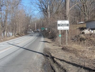
Entering Orange County, New York State.
RANKED BY RELEVANCE
| On New York State Route 94 at Barrett Rd, on the right when traveling east on New York State Route 94. |
| On Winkler Place near Howland Street & Greycourt Avenue. |
| On Main Street (New York State Route 207) at Erie Street on Main Street. |
| On U.S. 209 north of Swartwout Road, on the right when traveling north. |
| Near New York State Route 17A 0.4 miles Gibson Rd (County Route 100), on the right when traveling south. |
| On Pike Street (U.S. 6/209) west of Broome Street, on the right when traveling west. |
| On Main Street (Pennsylvania Route 487) south of Broad Street, on the right when traveling north. |
| On Main Street (U.S. 5) 0.1 miles north of Oxbow Road, on the left when traveling north. |
| On South Main Street (U.S. 34) at West Central Avenue, on the right when traveling south on South Main Street. |
| On South Main Street at Church Street (Dvorak Memorial Highway) (County Highway B16), on the left when traveling north on South Main Street. |
| On Orange Heritage Trail 0.1 miles east of Greycourt Avenue. |
| On Millpond Parkway 0.1 miles east of Route 17M. |
| On Paramount Boulevard 0.5 miles north of California Route 91, on the left when traveling north. |
| Near North Forest Avenue at Corrine Drive, on the left when traveling north. |
| On Green Street 0.1 miles west of South Street, on the right when traveling west. |
| Near Interstate 4 at milepost 96, 2.5 miles east of State Road 434, on the right when traveling east. |
| Near Interstate 4 at milepost 95 east of State Road 434, on the right when traveling west. |
| On Washington Street south of West 3rd Street, on the right when traveling south. |
| On Goshen Turnpike (Route 101) at Midland Lake Road, on the right when traveling north on Goshen Turnpike. |
| On Dutch Hill Road north of Orangeburg Road, on the right when traveling south. |
| On Sickles Avenue, on the right when traveling north. |
| On Main Street (U.S. 5) south of Chapel Street, on the right when traveling south. |
| On Main Street (New York State Route 207) at Park Place, on the right when traveling north on Main Street. |
| On Medoc State Park Road 1 mile south of North Carolina Route 4, on the right when traveling south. |
| On W Central Boulevard 0.1 miles N. Court Street, on the left. |
| On North Central Avenue (State Road 419/434) at Railroad Street, on the left when traveling north on North Central Avenue. |
| On Red Cleveland Boulevard 0.3 miles west of East Airport Blvd, on the left when traveling south. |
| On River Road at County Road 69, on the right when traveling north on River Road. |
| On Park Avenue (New York State Route 42) north of W Main Street, on the left when traveling north. |
| On New York State Route 284 at State Line Road, on the left when traveling north on New York State Route 284. |
| On New York State Route 97 north of the bridge over East Branch of the Delaware River, on the left when traveling north. |
| On Lower Main Street (New York State Route 133) at the connector to Upper Main Street, on the right when traveling west on Lower Main Street. |
| On Park Place south of Main Street ( Route 207), on the right when traveling north. |
| On Camino Capistrano north of Del Obispo Street, on the right when traveling north. |
| Near West 7th Street just west of Myrtle Avenue, on the right when traveling west. |
| On NY Rt 207 (New York State Route 207) at Maybrook Rd, on the right when traveling east on NY Rt 207. |
| On Main Street (New York State Route 207) 0.2 miles south of Scotchtown Road (County Route 83), on the right when traveling south. |
| On New York State Route 211 at Bodine Tavern Road ( Route 211), on the right when traveling west on New York State Route 211. |
| On East Main Street (U.S. 6) west of Ferguson Avenue, on the right when traveling west. |
| On Water Street at 3rd Street, on the right when traveling north on Water Street. |
| Near Havell Street at Jenkins Court. |
| On S Churton Street (U.S. 70), on the right when traveling south. |
| On Lakeview Parkway near Shoosmith Road, on the left when traveling north. |
| On Main Street (Nova Scotia Route 3), on the right when traveling east. |
| Near Katella Avenue near Disneyland Drive. |
| Near North State College Boulevard. |
| On Palmyra Avenue at Orange Street, on the right when traveling west on Palmyra Avenue. |
| On Brookside Avenue (New York State Route 17M) north of West Avenue, on the left when traveling north. |
| On Sickles Avenue, on the right when traveling north. Reported missing. |
| On Main Street (New York State Route 67) east of Wisner Avenue, on the left when traveling east. |
| On U.S. 9W, on the right when traveling north. |
| On Upper Court Street (New York State Route 11), on the right when traveling west. |
Thin black lines indicate changes in relevance. Between each pair of lines entries are ordered geographically but all have the same relevance.* Inflectional forms of words are their plurals, singulars, and possessives as well as gramatical tenses and similar variations.
Nov. 13, 2026
