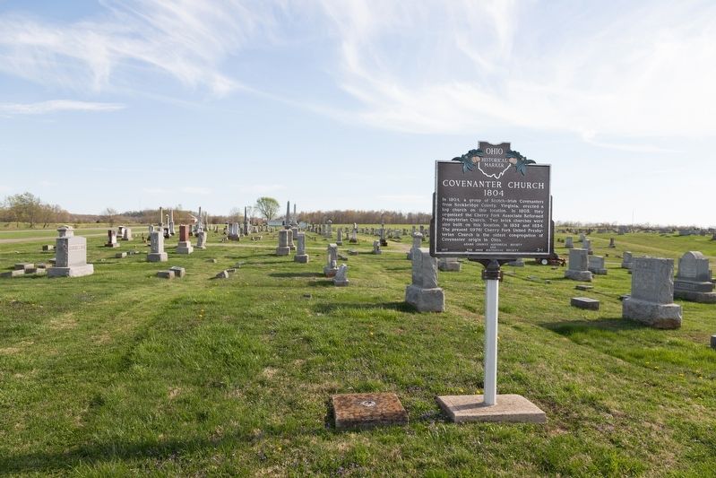
By J. J. Prats, April 16, 2019
Covenanter Church Marker
GEOGRAPHIC SORT Title Sort Marker Number Sort Marker Number Sort for Trails Publication Order Sort Publication Order Sort A Erected Year Sort Most Viewed Sort Most Recent-Interest Sort Most Recently Changed Sort SEE FAQ #33 FOR DESCRIPTIONS
On Ohio Route 138 south of 2nd Street (U.S. 137), on the right when traveling south.
On 2nd Street (U.S. 52) west of Jack Roush Way, on the right when traveling west.
On East 2nd Street (U.S. 52) 0.5 miles east of Cemetery Street, on the right when traveling west.
On Jack Roush Way (Ohio Route 136) at Brown Hill Road (County Route 3) on Jack Roush Way.
On Ohio River Scenic Byway (U.S. 52) at Yates Road, on the right when traveling east on Ohio River Scenic Byway.
On East Front Street at Pike Avenue, on the right when traveling east on East Front Street.
On West Front Street at Pearl Street, on the right when traveling west on West Front Street.
On 2nd Street (U.S. 52) east of Cemetery Street, on the right when traveling east.
On North Main Street (Ohio Route 41) near Elliott Avenue, on the right when traveling north.
Near Ohio Route 73 west of Horner Chapel Road (Local Route 116), on the right when traveling west.
On Ohio Route 41 at Adkins Rd, on the right when traveling north on Ohio Route 41.
On Ohio River Scenic Byway (U.S. 52) 0.3 miles west of Blue Creek Road (County Highway 18), on the right when traveling west.
On Main Street (Ohio Route 247) south of Tri County Road, on the right when traveling south.
On West Main Street (Ohio Route 41) at North Cherry Street, on the right when traveling west on West Main Street.
On North Cross Street at West Main Street, on the right when traveling north on North Cross Street.
Paid Advertisement
On Second Street (Ohio Route 247) at East Walnut, on the left when traveling south on Second Street.
Near South Cherry Street south of West South Street, on the right when traveling south.
On West South Street at South West Street, on the left when traveling west on West South Street.
On Manchester Street (Ohio Route 41) 0.1 miles east of McHenry Street (County Route 70) when traveling east.
On North Cherry Street west of North Cross Street ( Route 247), on the right when traveling west.
On Ohio Route 41 at Texas Street, on the right when traveling north on Ohio Route 41.
On Main Street at Route 32, on the right when traveling north on Main Street.
On East Washington Street at Main Street ( Route 136), on the right when traveling west on East Washington Street.
On Main Street (Ohio Route 136) at Dorsey Road (Local Route 48) on Main Street.
On Bentley Road near Riley Street, on the right when traveling south.
On Lincoln Highway (U.S. 30) at George Street, on the right when traveling west on Lincoln Highway.
On Napoleon Road 0.2 miles north of West 1st Street, on the right when traveling south.
On North Wanut Street at West 2nd Street, on the right when traveling north on North Wanut Street.
On Lafayette Road 0.1 miles north of Ada Road ( Route 81), on the right when traveling north.
On North Street, on the left when traveling east.
On North West Street (Ohio Route 68) at West Chapman Road, on the right when traveling south on North West Street.
Paid Advertisement
On Elm Street, on the left when traveling east.
On Central Avenue, in the median.
On Metcalf Street at Paul Street, on the right when traveling south on Metcalf Street.
On Market Street, on the left when traveling east.
On North McClure Road 1 mile south of Route 81, on the left when traveling south.
On South Broadway Street (Ohio Route 66) north of Wurster Drive, on the right when traveling north.
On Center Street (Ohio Route 511) 1 mile south of McKinley Boulevard, on the right when traveling north.
On Johnny Appleseed Historic Byway (Ohio Route 603) north of Local Highway 2256, on the right when traveling north.
On South Mechanic Street (Ohio Route 60) just south of Main Street ( Route 179), on the right when traveling north.
On South Mechanic Street (Ohio Route 60) 0.3 miles north of County Route 775, on the right when traveling north.
On Mechanic Street (Ohio Route 60) at Main Street ( Route 179), on the left when traveling south on Mechanic Street.
On East Main Street at South Pleasant Street on East Main Street. Reported permanently removed.
On South Market Street (Ohio Route 3) at East Main Street ( Route 39), on the left when traveling south on South Market Street.
Near Gorge Overlook, on the right when traveling east.
On Ohio Route 3 0.5 miles north of Route 97, on the right when traveling north.
Paid Advertisement
On Lincoln Highway (County Route 30A) at Iowa Street, on the right when traveling west on Lincoln Highway.
On Ohio Route 39, on the right when traveling west.
On Ohio Route 39 1 mile north of Route 95, on the left when traveling north.
On Pymatuning Lake Road (County Route 274) 1.2 miles north of Martin Road (County Route 269), on the left when traveling south.
On Bridge Street at Morton Street, on the right when traveling west on Bridge Street.
On Lake Avenue at West 27th Street, on the right when traveling north on Lake Avenue.
On Main Avenue 0.1 miles north of West 48th Street, on the right when traveling north.
On Lakeshore Drive 0.5 miles Route 531, on the right when traveling west.
On Walnut Boulevard at West 1st Street, on the right when traveling west on Walnut Boulevard.
On Center Road (Ohio Route 45) 0.1 miles north of Lampson Road, on the right when traveling south.
Near Main Street at Broad Street.
On South Broadway (Ohio Route 534) south of Greenridge Drive, on the right when traveling south.
On U.S. 20 0.1 miles west of North Eagle Street, on the right when traveling west.
On Harpersfield Road at State Road, on the left when traveling north on Harpersfield Road. Reported missing.
On East Jefferson Avenue 0.1 miles east of Market Street, on the right when traveling east.
On South Maple Street (Ohio Route 45) at U.S. 322, on the right when traveling north on South Maple Street.
Paid Advertisement
On West Clinton Street at Washington Road, on the right when traveling west on West Clinton Street.
On Ohio Route 550 south of Jago Valley Road (County Road 478), on the right when traveling east.
On Main Street (Ohio Route 329) 0.3 miles south of Linscott Run Road (County Route 41), on the right when traveling south.
On State Street (Ohio Route 550), on the right when traveling east.
On Carpenter Street at North Court Street, on the left when traveling east on Carpenter Street.
On Country Club Road (Local Road 559) south of State Route 56, on the left when traveling south.
On West Carpenter Street just east of North Congress Street, on the right when traveling west.
On Union Street at Court Street, on the right when traveling east on Union Street.
On South Green Drive 0.1 miles east of Richland Avenue (U.S. 50), on the right when traveling east.
On Ohio Route 13 south of Main Street, on the right when traveling south.
On High Street (Ohio Route 13), on the right when traveling south.
On Hocking Parkway near West Canal Street (U.S. 33), on the right when traveling south.
On West Washington Street at John Lloyd Evans Memorial Drive, on the right when traveling east on West Washington Street.
On Fort Street 0 miles south of East Washington Street, in the median.
On National Road (County Road 208) at North Dixie Highway (County Road 25A), on the right when traveling west on National Road.
Paid Advertisement
On Main Street at the CSX railroad tracks, on the left when traveling west on Main Street.
On Dixie Highway south of Coon South Lane, on the right when traveling north.
Near Ohio Route 198 0.2 miles south of Deep Cut Road.
On Ohio Route 198 south of Deep Cut Road (Local Highway 230), on the right when traveling north.
On Ohio Route 198 0.2 miles south of Deep Cut Road (Local Highway 230), on the right when traveling north.
On Ohio Route 198 0.3 miles south of Deep Cut Road (Local Highway 230), on the right when traveling north.
On Ohio Route 198 0.3 miles south of Deep Cut Road (Local Highway 230), on the right when traveling north.
On Main Street (Ohio Route 66) 0.1 miles south of Bensman Road (U.S. 40), on the right when traveling south.
On Ohio Route 119 east of North Paris Street, on the right when traveling west.
On West Monroe Street (Ohio Route 274) at South Washington Street (Route 66), on the right when traveling east on West Monroe Street.
On North Main Street at East Bremen Street, on the left when traveling north on North Main Street.
On East High Street west of North Chestnut Street, on the right when traveling west.
On North Spruce Street (Ohio Route 66) at Oil Street, on the right when traveling south on North Spruce Street.
On Celina Road (Ohio Route 703) west of Royal Oak Drive, on the right when traveling east.
On Auglaize Street at Broadway, on the right when traveling east on Auglaize Street.
On South Blackhoof Street at Main Street, on the right when traveling north on South Blackhoof Street.
Paid Advertisement
On West Benton Street at Buchanan Street, on the left when traveling west on West Benton Street.
On Santa Fe-New Knoxville Road (County Route 100) at Cemetery Rd (County Route 161), on the left when traveling east on Santa Fe-New Knoxville Road.
On Auglaize Street, on the right when traveling west.
On Lincoln Avenue (Ohio Route 501) 0.1 miles south of Redskin Trail, on the right when traveling south.
On Bellefontaine Street at Apollo Drive, on the right when traveling west on Bellefontaine Street.
︽
2067 entries matched your criteria. The first 100 are listed above.
Next 100 ⊳