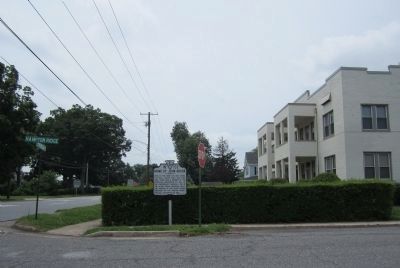
On Longwood Avenue (U.S. 221) at Hampton Ridge, on the right when traveling west on Longwood Avenue.
Here is the home of John Goode, political leader, born 1829, died, 1909. Goode was a member of the secession convention of 1861; of the Confederate Congress and of the United States Congress; Solicitor General of the United States; president of the . . . — — Map (db m42877) HM
On West Lynchburg Salem Turnpike (U.S. 460) 0.3 miles west of Patterson Mill Road (Virginia Route 680), in the median.
Near here General Hunter, on his retreat from Lynchburg, halted for the night of June 18, 1864. He resumed his retreat early in the morning of June 19. — — Map (db m42875) HM
Near Overlord Circle 0.4 miles west of Burks Hill Road, on the right when traveling south.
“Bedford Boys” from Company A, 116th Infantry Regiment, 29th Division killed in action on D-Day, 6 June 1944.
Leslie C. Abbott, Jr. • Wallace R. Carter • John D. Clifton • Frank P. Draper • Tayler N. Fellers • Nick N. Gillaspie • Bedford T. . . . — — Map (db m256274) WM
On East Lynchburg-Salem Turnpike (U.S. 460) west of Hull Street, on the right when traveling west.
Within a few miles of here lived and died Joel Leftwich, militia general, legislator, justice of the peace, and Revolutionary War veteran. In the War of 1812, he commanded a brigade of Virginia militia that marched in the winter of 1812-1813 to . . . — — Map (db m305732) HM
Near Overlord Circle 0.4 miles west of Burks Hill Road.
Chief of Staff, Hawaiian Department (1941-1942); Commander, 25th Infantry Division (1942-1943); Commander VIl Corps (1944-1945); Chief of Army Information (1945-1947);
Deputy Chief of Staff, U.S. Army (1947-1949): Chief of Staff, U.S. Army . . . — — Map (db m242019) HM WM
Joseph Stalin
21 December 1879 - 5 March 1953
General Secretary of the Communist Party
In 1922, Joseph Stalin became General Secretary of the Communist Party of the Union of Soviet Socialist Republics and spent the next seven years . . . — — Map (db m240663) HM WM
On Overlord Circle 0.7 miles west of Burks Hill Road (Virginia Route 122), in the median.
Edmond de Laheudrie was born in Trévières, France, where he served as mayor from 1896 through 1900. Classically trained as a sculptor, he studied at Paris under Pierre Jules Cavelier (1814-1896), Louis Ernest Barrais (1841-1905), and Marius Jean . . . — — Map (db m306181) HM WM
Near Overlord Circle 0.4 miles west of Burks Hill Road.
Perhaps inspired by President Franklin Delano Roosevelt's homey metaphor of a person lending a neighbor a garden hose to extinguish his burning house then getting it back when the fire is out, the initiative that came to be known as Lend Lease was . . . — — Map (db m240806) HM WM
Near Bedford Avenue, on the right when traveling east.
As in other small towns, Bedford's railroad station was a hub of community life. Transportation of passengers, freight and mail meant that railroad stations were a vital part of both the local and national economy. World War II found this particular . . . — — Map (db m306747) HM WM
On E Lynchburg Salem Turnpike (Virginia Route 460) 7.5 miles west of Bedford/Campbell County Line, on the right when traveling west.
The Lynchburg and Salem Turnpike Co. was incorporated in 1818 to build a turnpike from Lynchburg west to Salem. The road reached Liberty (now Bedford) in 1828 and was completed to Salem in 1836. In Bedford County, covered bridges spanned the Big . . . — — Map (db m18830) HM
On Avenel Avenue south of Peaks Street ( Route 43), on the right when traveling south.
This beautiful garden and circle were constructed in loving memory of Marilyn Moore Boardman by her husband John King Boardman and four daughters, Scottie Boardman House, Holly Boardman Burton, Beth Boardman Grant and Cathy Boardman. Marilyn was . . . — — Map (db m298706) HM
Near Overlord Circle 0.4 miles west of Burks Hill Road.
One of the major components of the National D-Day Memorial, Lawhorne Circle, named for Lieutenant Maurice T. Lawhorne, Army Air Force, recognizes the service and contributions of the Allied Air Forces in support of the Normandy landing and Operation . . . — — Map (db m242033) HM WM
Near Overlord Circle 0.4 miles west of Burks Hill Road.
Médaille commémorative de la guerre
Of Belgium's military medals for the Second World War, the Médatile commémorative de la guerre 1940-1945 had the broadest circulation. Established on 16 February 1945, the War Commemorative Medal . . . — — Map (db m240426) HM WM
Near Overlord Circle 0.4 miles west of Burks Hill Road.
Military Police (MP) Platoons
Normandy, France, June - August 1944
The Military Police Corps is the uniformed law enforcement branch of the United States Army. At Normandy, as for other combat operations, MP platoons had the . . . — — Map (db m240389) HM WM
On Morgans Church Road east of Feldspar Road, on the right when traveling east.
Morgans Baptist Church, earlier known as Goose Creek Church, was organized in 1771 and is the oldest-existing Baptist church in Bedford County. The congregation, consisting of black and white members until the 1860s, met along Goose . . . — — Map (db m298715) HM
Near Overlord Circle 0.4 miles west of Burks Hill Road.
Following the disastrous raid at Dieppe on the French coast in August 1942, Allied commanders realized that while a port would be essential to any invasion of occupied France, it need not necessarily be wrested from enemy hands. Instead, the idea of . . . — — Map (db m241116) HM WM
On West Main Street (U.S. 221) at South Bridge Street, on the left when traveling west on West Main Street.
In April 2024, Bedford Get Together, Inc. issued a call for artists to create a mural honoring the contributions of Bedford's diverse military community. This vision pays tribute to the service and sacrifice of all military members, emphasizing . . . — — Map (db m298709) HM
Near Overlord Circle 0.4 miles west of Burks Hill Road.
The modest Dutch military force that escaped to England when the Netherlands fell did not participate in Operation Overlord. A cruiser, HMNS Sumatra, and two gunboats did represent the Dutch Navy in Operation Neptune. The two gunboats fired . . . — — Map (db m240038) HM WM
Near Overlord Circle 0.4 miles west of Burks Hill Road.
>br>About 30,000 members of the Royal New Zealand Air Force were in Operation Overlord. Squadrons of New Zealand's fighters and bombers flew in every phase, the former performing with particular efficacy above Omaha Beach on D-Day. Some 4,000 . . . — — Map (db m240047) HM WM
Near Overlord Circle 0.4 miles west of Burks Hill Road.
Since the commencement of World War II, the New Zealand Memorial Cross has been presented to the next of kin of the New Zealand servicemen and women killed during war service, operational service overseas, or who later died of wounds received in the . . . — — Map (db m240431) HM WM
Near Overlord Circle 0.4 miles west of Burks Hill Road.
Organized at Camp Sheridan, Alabama, on 18 July 1918, the 9th Infantry Division was the last Regular Army division activated for World War I. It disbanded on 15 February 1919. Reactivated on 1 August 1940 at Fort Bragg, North Carolina, the division . . . — — Map (db m240172) HM WM
Near Overlord Circle 0.4 miles west of Burks Hill Road.
Established at Bowman Field, Kentucky, as V Air Support Command on 21 August 1941 and activated on 1 September, the fledgling unit was redesignated 9th Air Force on 8 April 1942 and assigned, on 22 July 1942, to Bolling Field, Washington, DC. On 18 . . . — — Map (db m241237) HM WM
Near Overlord Circle 0.4 miles west of Burks Hill Road.
Ten warships of the Royal Norwegian Navy in exile took part in Operation Neptune. The Svenner! a brand new destroyer, was struck midship by a German torpedo at H-1 and went down in a quarter-hour. The Norwegian Merchant Navy also committed . . . — — Map (db m240052) HM WM
Near Overlord Circle 1 mile west of Burks Hill Road ( Route 122).
Omar Nelson Bradley
12 February 1893 - 8 April 1981
Commanding General, United States First Army
A 1915 graduate of the United States Military Academy, Omar Bradley was first among the fifty-nine general officers in "the class the stars . . . — — Map (db m240251) HM WM
Near Overlord Circle 0.4 miles west of Burks Hill Road.
Activated at Camp Claiborne, Louisiana, on 15 August 1942 to become the U.S. Army's second division of airborne infantry, the "Screaming Eagles" came into being under the command of Brig. Gen. William C. Lee, who told his troops, "the 101st has no . . . — — Map (db m240785) HM WM
Operation Fortitude stands out as one of the most vital contributions made by the Allied staff during the planning and preparation for the D-Day invasion. Formulated as a plan "to induce the enemy to make faulty dispositions in northwest Europe . . . — — Map (db m240304) HM WM
Near Overlord Circle 0.4 miles west of Burks Hill Road.
Established in 1802 by Napoleon Bonaparte, the French National Order of the Legion of Honor recognizes meritorious service to the French republic. The order is open to military personnel and civilians, citizens and foreigners, men and women alike, . . . — — Map (db m241987) HM WM
On Blue Ridge Parkway near Peaks Road ( Route 43).
(preface)
On May 26, 1864, Union Gen. David Hunter marched south from Cedar Creek near Winchester to drive out Confederate forces, lay waste to the Shenandoah Valley, and destroy transportation facilities at Lynchburg. His raid was part of . . . — — Map (db m55780) HM
On Peaks Street (Virginia Route 43) at Longwood Avenue (U.S. 221), on the right when traveling north on Peaks Street.
This road was followed by General Hunter when he crossed the Blue Ridge at the Peaks of Otter and came to Bedford en route to Lynchburg, June 16, 1864. — — Map (db m42893) HM
Near Overlord Circle 0.4 miles west of Burks Hill Road.
Mindful of Germany's September 1, 1939
invasion of Poland, the government-in-exile was eager for its forces to participate in D-Day. Polish ground troops did not deploy until later, but the Polish Wing of the 84th Royal Air Force Group and a Polish . . . — — Map (db m240057) HM WM
Near Blue Ridge Parkway (at milepost 86), 0.6 miles Peaks Road ( Route 43).
Built in the early 1800's, this simple mountain cabin was operated as an inn, or "ordinary", from about 1830 until about 1850. Here the widowed Polly Woods catered to the "ordinary" needs of the weary mountain traveler -- a hot meal, a comfortable . . . — — Map (db m9655) HM
Near Overlord Circle, on the left when traveling north.
Franklin Roosevelt led the nation in this prayer by radio, June 6, 1944:
Almighty God: Our sons, pride of our Nation, this day have set upon a mighty endeavor, a struggle to preserve our Republic, our religion, and our civilization, . . . — — Map (db m306725) WM
Near Overlord Circle 0.4 miles west of Burks Hill Road.
Purple Heart
By order issued at his headquarters at Newburgh, New York, 7 August 1782, General George Washington designated the Purple Heart as the Army's Badge of Military Merit. He presented it to three sergeants, and it was not . . . — — Map (db m240419) HM WM
On Shingle Block Road (Virginia Route 24) at Wilson Church Road (County Route 722), on the right when traveling west on Shingle Block Road.
A Quaker Meeting was established on Goose Creek in 1757, and a meeting house built. Fear of Indians caused most of the Quakers to move elsewhere though some of them returned. Unsuccessful attempts were made to re-establish the Goose Creek Meeting. . . . — — Map (db m65610) HM
On College Street west of Mountain Avenue, on the right when traveling east. Reported permanently removed.
Randolph-Macon Academy, a Methodist preparatory school for boys, occupied a building on this site from 1890 until 1934 when the school was consolidated with the Randolph-Macon Academy at Front Royal. In 1936, the property was purchased by Bedford . . . — — Map (db m42878) HM
On College Street east of Ashland Avenue, on the right when traveling east.
The trustees of Randolph-Macon College, a Methodist institution in Ashland, opened Randolph-Macon Academy here in 1890. A preparatory school for boys, it attracted local students as well as boarders from other regions of Virginia and beyond. The . . . — — Map (db m298697) HM
Near Overlord Circle 0.9 miles west of Burks Hill Road, on the left when traveling east.
For any modern military force, a reliable, efficient method of keeping troops supplied is essential. For the American army in Europe in 1944, the need was especially acute. The mechanized army relied on rapid movement of fuel, ammunition, . . . — — Map (db m306197) HM WM
Near Overlord Circle 0.4 miles west of Burks Hill Road.
A native of Bristol, Virginia, who attended King College, Columbia University, and the University of Virginia, industrialist-poet Richard S. Reynolds Sr. founded Reynolds Metals Company. In 1935, he presciently selected an image of St. George . . . — — Map (db m241210) WM
Near Overlord Circle 0.4 miles west of Burks Hill Road.
Richard S. Reynolds Sr. (1881-1955) was an industrialist and poet, whose breadth of vision, common sense, and patriotism compelled him to take uncommon risks to prepare the American aluminum industry for war. The penultimate stanza of his poem “An . . . — — Map (db m241879) HM WM
On Overlord Circle 0.8 miles west of Burks Hill Road ( Route 122).
Robey W. Estes Sr. served with the United States Army in the European Theater of Operations. A platoon sergeant in Company E of the 116th Infantry Regiment on D-Day, he was part of the first wave of the attack on Omaha Beach. Wounded during the . . . — — Map (db m61339) HM WM
Near Overlord Circle 0.4 miles west of Burks Hill Road.
Robey W. Estes Sr. Plaza is the third major element of the National D-Day Memorial.
A stylized triumphal arch bearing the invasion's code name (Overlord) surmounts the plaza, rising forty-four and one half feet high (for 6/6/44). Estes Plaza . . . — — Map (db m240142) HM WM
Near Overlord Circle 0.4 miles west of Burks Hill Road.
Some visitors viewing the twenty-foot tall bronze relief mounted on the wall below the Overload Arch might suppose that the sculpture pays particular tribute to the members of the 2nd Ranger Battalion who ascended the cliffs at Pointe du-Hoc. Such a . . . — — Map (db m242038) HM WM
Near Overlord Circle 0.4 miles west of Burks Hill Road.
Commissioned at Camp Bradford, Virginia, in late March of 1943 under Commander John F. Curtin, the 2nd Naval Beach Battalion (NBB) was the most seasoned of the three NBBs to participate in the D-Day assault on Normandy. The 2nd NBB, along with the . . . — — Map (db m240769) HM WM
Near Overlord Circle 0.4 miles west of Burks Hill Road.
One of two battalions that on D-Day made up the Provisional Ranger Group (PRG) under the command of Lt. Col. James E. Rudder, the Second Ranger Battalion was activated at Camp Forest, Tennessee, on 1 April 1943. For the landing, the PRG was . . . — — Map (db m241814) HM WM
Near Overlord Circle 0.4 miles west of Burks Hill Road.
The Second World War Mothers and Widows Badge was a silver-colored disk authorized for issue to the mothers and widows of members of the Royal Australian Navy, Australian Imperial Force, Citizens Military Forces, and Royal Australian Air Force . . . — — Map (db m240422) WM
Near Overlord Circle 0.4 miles west of Burks Hill Road.
Commissioned on 5 October 1943 at Camp Bradford, Virginia, under Commander L. C. Leever, the 7th Naval Beach Battalion (NBB) was later filled with unassigned sailors and men drawn from the 1st, 2nd, 3rd, and 6th NBBs. At full strength, NBBs . . . — — Map (db m240855) WM
Rising abruptly from the surrounding terrain, Sharp Top Mountain attracted the attention of Indians 8,000 years ago just as it attracts parkway visitors today. Many hikers ascend the peak by way of this strenuous 1.5-mile trail. Others prefer the . . . — — Map (db m276864) HM
Near Peaks Road (State Highway 43), on the right when traveling east.
Sharp Top, famous observation point, was once thought to be Virginia's highest peak. From it came the Virginia stone in the Washington Monument which is inscribed: "From Otter's Summit, Virginia's loftiest peak, to crown a monument to Virginia's . . . — — Map (db m280666) HM
On East Main Street (U.S. 460) at South Street ( Route 43), on the right when traveling east on East Main Street.
Site of
Bedford County Court House
1782
This building
Mercantile Establishment
1842
Abel B. Nichols, owner
Builder of "Three Otters"
This building at 202 E. Main Street is identified as a significant contributing . . . — — Map (db m266563) HM
Near Overlord Circle 0.4 miles west of Burks Hill Road.
On 23 April 1943, Major General Richard N. “Windy" Gale, a veteran brigade commander who had served with the 1st Airborne Division (British) in North Africa, received orders to raise the 6th Airborne Division and lead its preparations for the Allied . . . — — Map (db m241270) HM WM
On Overlord Circle 0.4 miles west of Burks Hill Road.
Commissioned on 9 October 1943 at Camp Bradford, Virginia, under Commander Eugene C. Carusi, USNR, the 6th Naval Beach Battalion (NBB) moved to Fort Pierce, Florida, for amphibious-warfare training. On D-Day, the 6th NBB would number about 400 . . . — — Map (db m251254) HM WM
On West Main Street at Crenshaw Street, on the right when traveling west on West Main Street.
Although Bedford County was primarily an agricultural region in the 1940s, several impressive industries could be found along the railroad tracks. Smyth represents one of those businesses that played such a large role in the community. Like most . . . — — Map (db m306739) HM
On Morgans Church Road east of Feldspar Road, on the right when traveling east.
Style block
also referred to as a
horse block
was used to assist parishioners in mounting and dismounting from their horses, buggies and wagons
Erected - August 25, 1897
by the men of the church
Restored & memorialized . . . — — Map (db m298716) HM
Near Overlord Circle 0.4 miles west of Burks Hill Road.
In the autumn of 1943, British Lt. Gen. Frederick Morgan, Chief of Staff to the Supreme Allied Commander (COSSAC), directed the creation of a shoulder sleeve insignia (patch) for the use by the Supreme Commander of the Allied Expeditionary Forces . . . — — Map (db m240316) HM WM
On Burks Hill Road (Virginia Route 122) at Tiger Trail, on the left when traveling north on Burks Hill Road.
Susie G. Gibson (1878-1949), teacher and community activist, was Bedford County's supervisor of African American education for 22 years. Her work was sponsored by the Jeanes Fund, established in 1907 to enhance opportunities for Black students in . . . — — Map (db m243627) HM
Near Overlord Circle 0.4 miles west of Burks Hill Road.
On 29 December 1940, President Franklin D. Roosevelt announced "it is the purpose of the nation to build now with all possible speed every machine, every arsenal, every factory that we need to manufacture our defense material. We have the men, the . . . — — Map (db m242057) HM WM
Near Overlord Circle 0.4 miles west of Burks Hill Road.
On Sunday, 25 June 1944 Ivylyn Schenk wrote from her home in Bedford to her husband who was serving with the 29th Infantry Division and stationed in Europe. She wrote him faithfully each day and on this particular day was excited to acknowledge . . . — — Map (db m241543) HM WM
Near Peaks Road (State Highway 43), on the right when traveling north.
Cherokee and Souian Indians quenched their thirst at the Big Spring. It provided a refreshing stop-over for the pioneer, the wagon freighters of the revolution, and later the stage coach travelers. Today, clear and cool as ever, it pours forth . . . — — Map (db m280839) HM
Near Overlord Circle 0.4 miles west of Burks Hill Road.
In honor of all graduates and former cadets of The Citadel, The Military College of South Carolina, who participated in the Great Crusade to overthrow oppression and tyranny and bring about peace and security to Europe.
We dedicate this plaque . . . — — Map (db m242083) WM
Near Overlord Circle 0.4 miles west of Burks Hill Road.
Formed at Camp Gordon, Georgia, on 25 August 1917, the 82nd Infantry Division comprised soldiers from all 48 states; hence the nickname and double-A shoulder patch. After fighting with distinction in three World War I campaigns, the division . . . — — Map (db m240728) HM WM
On Ashland Avenue 0.2 miles north of College Street, on the left when traveling north.
The Elks National Home has been placed on the National Register of Historic Places and the Virginia Landmarks Register as an Historic District. — — Map (db m306753) HM
On West Main Street (U.S. 221) at South Bridge Street, on the right when traveling east on West Main Street.
In February 1941, Co. A of the 116th Regiment, WA National Guard, kissed mothers and girlfriends goodbye and filed onto a waiting train at Bedford's depot. They had been called up for a one-year assignment in the regular army; with the nation . . . — — Map (db m266558) HM
Near Overlord Circle 0.4 miles west of Burks Hill Road.
The Glider Pilot Regiment
“Nothing is Impossible”
The Glider Pilot Regiment was raised in 1941 on the order of the Prime Minister, Winston Churchill, and formally inaugurated on 24th February 1942 as part of the British Army . . . — — Map (db m240390) WM
Near Blue Ridge Parkway, on the right when traveling south.
The Peaks of Otter area has long been a favorite stopover for travelers. Benjamin Wilkes and his son, Leyburn, opened the Hotel Mons on this site in 1857. The hotel became a popular vacation resort, and Wilkes expanded his operation as public demand . . . — — Map (db m280846) HM
Near Overlord Circle, on the left when traveling north.
Presented by the President in the name of Congress, the Medal of Honor is the highest decoration bestowed upon members of the United States Military, awarded only sparingly, it recognizes extraordinary heroism involving conspicuous acts of . . . — — Map (db m306379) HM WM
Formed on 1 April 1918, the Royal Air Force is the world's oldest independent air force. During World War II, the RAF had three front-line commands: Coastal Command, Fighter Command, and Bomber Command.
RAF Coastal Command had a D-Day . . . — — Map (db m241245) HM WM
Near Overlord Circle 0.4 miles west of Burks Hill Road.
On D-Day the US First Army comprising two
corps (five divisions with auxiliary units and services - about 73,000 troops) landed on and around Omaha Beach, Utah Beach, and the
Cotentin Peninsula. The US provided 16.5 percent of the Allied warships . . . — — Map (db m240078) HM WM
Near Overlord Circle 0.4 miles west of Burks Hill Road.
The United States Marines in the European Theater
“Semper Fidelis”
For nearly 250 years, United States Marines have been found wherever American lives and interests were in jeopardy. World War Il Europe was no exception. Well . . . — — Map (db m240392) HM WM
On North Bridge Street north of Bedford Avenue, on the left when traveling north.
The Wharton Cottage was built by John A. and Isabella Brown Wharton in 1847, exemplifying the Carpenter Gothic style of architecture that was popular in the mid-nineteenth century. This style emphasized charm and quaintness while using an abundant . . . — — Map (db m305745) HM
Near Overlord Circle 0.4 miles west of Burks Hill Road.
Formed in 1940 by citizen-soldiers recruited to serve in units named for their home regions (e.g. Winnipeg Rifles, Regina Rifles, North Nova Scotia Highlanders, etc.), the 3rd Canadian Infantry Division was commanded by Maj. Gen. R. F. L. Keller. . . . — — Map (db m241296) HM WM
Near Overlord Circle 0.4 miles west of Burks Hill Road.
Arthur Wellesley, first Duke of Wellington, formed the division in 1809 to serve in the Peninsula War. Known during the Napoleonic Wars as the "Fighting Third," the division fought at the Battle of Waterloo and later in the Crimean War and Second . . . — — Map (db m241258) HM WM
Near Overlord Circle, on the left when traveling south.
Nearly 7000 naval vessels were used in Operation Neptune on D-Day (the assault phase of Operation Overlord), including six battleships and more than twenty cruisers. Naval action was critical to moving troops ashore, defending the landings, and . . . — — Map (db m306571) HM
Trafford Leigh Leigh-Mallory
11 July 1892 - 14 November 1944
Commander in Chief, Allied Expeditionary Force Air Force
Trafford Leigh-Mallory read law at Magdalene College, Cambridge, where he met Arthur Tedder. Serving in the . . . — — Map (db m240803) HM WM
Little recognized in popular histories of the Second World War, the U.S. Navy Armed Guard (USNAG) and U.S. Merchant Marine (USMM) played a central role in transporting the personnel and material the Allies needed to achieve victory. In the process . . . — — Map (db m241168) HM WM
Near Overlord Circle 0.4 miles west of Burks Hill Road.
Facing a shortage of men to build additional ships and create new bases and facilities in the wake of the 7 December 1941 bombing of Pearl Harbor, the Secretary of the Navy petitioned the U.S. Congress in January 1942, to establish a women’s . . . — — Map (db m241200) HM WM
Near Overlord Circle 0.4 miles west of Burks Hill Road.
On D-Day the British Second Army composed of two corps (including three British divisions with auxiliary units and services - some 62,000 Britons) landed on and around Gold Beach, Sword Beach, and along the Orne River toward Caen. The UK provided . . . — — Map (db m240058) HM WM
Near Overlord Circle 0.4 miles west of Burks Hill Road.
By the end of 1944, more than 6,500 nurses, all commissioned officers, were serving in the United States Army Air Forces (USAAF). Of that number, 500 were Flight Nurses based wherever casualties required evacuation by air. On entering the USAAF, all . . . — — Map (db m241242) HM WM
Near Overlord Circle 0.4 miles west of Burks Hill Road.
In our public memory of D-Day, the role of the United States Coast Guard too often goes unremarked. While Coast Guardsmen served in smaller numbers than their counterparts in the Army, Navy and Merchant Marine, their service was a vital ingredient . . . — — Map (db m241206) HM WM
Near Overlord Circle 0.4 miles west of Burks Hill Road.
Remember the
valor, fidelity, and sacrifice
of the graduates and alumni of the
United States Military Academy
on D-Day, 6 June 1944
Their leadership and service
In the climatic battle of the
Second World War . . . — — Map (db m241553) WM
Near Overlord Circle 0.9 miles west of Burks Hill Road, in the median.
The United States Naval Academy was established in 1845 at Annapolis, Maryland. Its mission is to develop midshipmen morally, mentally, and physically, and to imbue them with the highest ideals of duty, honor, and loyalty, and to provide the nation . . . — — Map (db m242249) HM WM
Near Overlord Circle, on the left when traveling south.
For the Normandy invasion, everything hinged on achieving a rapid build-up of Allied forces on the beaches. In addition to coastal defense, the German’s had sown thousands of mines throughout the English Channel. But, before any Allied soldier . . . — — Map (db m306570) HM
Near Overlord Circle 0.4 miles west of Burks Hill Road.
One of three American battleships in Operation Neptune, USS Arkansas was the oldest battleship in the U.S. Navy. She was laid down at Camden, New Jersey, on 25 January 1910, launched on 14 January 1911, and commissioned on 17 September . . . — — Map (db m241073) HM WM
Near Overlord Circle 0.4 miles west of Burks Hill Road.
USS Augusta, CA-31
“Augie Maru”
Awarded Three Battle Stars for World War II Service
Laid down on 2 July 1928, USS Augusta launched on 1 February 1930. Commissioned at the Norfolk Navy Yard on 30 January 1931, Augusta . . . — — Map (db m241119) HM WM
The British evacuation from Dunkirk, France, in 1940 made clear the need for ocean-going vessels capable of loading and landing large quantities of troops, cargo, and vehicles on an unimproved shore. The British Admiralty got busy and began design . . . — — Map (db m241161) HM WM
Near Overlord Circle 0.4 miles west of Burks Hill Road.
Laid down on 4 November 1912 by the Fore River Shipbuilding Company at Quincy, Massachusetts, USS Nevada launched on 11 July 1914. With Capt William S. Sims in command, Nevada commissioned on 11 March 1916, joined the Atlantic . . . — — Map (db m241101) HM WM
Near Overlord Circle 0.4 miles west of Burks Hill Road.
Named for LTJG Ralph McMaster Rich, posthumous recipient of the Navy Cross for "capable and aggressive leadership" during the Battle of Midway, USS Rich was laid down on 27 March 1943 at the Defoe Shipbuilding Company in Bay City, Michigan. . . . — — Map (db m241110) HM WM
The second battleship to bear the name, USS Texas was laid down at Newport News, Virginia, on 17 April 1911, launched on 18 May 1912, and commissioned on 12 March 1914, with Captain Albert W. Grant commanding. Without benefit of a shakedown . . . — — Map (db m241084) HM WM
Near Overlord Circle 0.4 miles west of Burks Hill Road.
Commemorating the
WWII Service of the
Virginia Military Institute
Citizen-Soldiers
who, in time of deepest peril, came
to the aid of their country.
Over 4,000 served,
185 gave their lives.
In every Branch, In . . . — — Map (db m241554) HM WM
Near Overlord Circle 0.4 miles west of Burks Hill Road.
Commemorating the Wartime Service and Sacrifice of the Citizen-Soldier Members of the Virginia Polytechnic Institute Corps of Cadets
Virginia Tech was founded as the Virginia Agricultural and Mechanical College in 1872 - Virginia's . . . — — Map (db m242898) HM WM
Near Overlord Circle 0.4 miles west of Burks Hill Road.
Mr. W.E. Stevens was a man of soil. He and his wife maintained a farm six miles outside the City of Bedford, Virginia. After the United States entered the Second World War, the government soon revived the World War I practice of victory gardening. . . . — — Map (db m243621) WM
Near Overlord Circle 0.4 miles west of Burks Hill Road.
Winston Leonard Spencer Churchill
30 November 1874 - 24 January 1965
Prime Minister of the United Kingdom,
10 May 1940 - 26 July 1945 and
26 October 1951 - 7 April 1955
First Honorary Citizen of the United States, 1963 . . . — — Map (db m240266) HM WM
Near Blue Ridge Parkway (at milepost 64), on the left when traveling south.
When George Washington stood here in 1772, he sought a way to open a water route to the West. Traveling over the region’s most rugged mountains was time consuming and dangerous. New settlers needed a more efficient way to transport goods like . . . — — Map (db m95959) HM
Near Blue Ridge Parkway (at milepost 64), on the left when traveling south.
The James River flows from the mountains through Lynchburg and Richmond to the coast. It is the largest river in Virginia and, historically, one of the state’s most important transportation corridors. Before the Civil War, investors built a canal . . . — — Map (db m95958) HM
Near Overlord Circle 0.4 miles west of Burks Hill Road.
Walter Bedell “Beetle” Smith
5 October 1895 - 89 August 1961
Chief of Staff, Supreme Headquarters, Allied Expeditionary Force
Enlisting in the Indiana National Guard at age sixteen, "Beetle" Smith earned a reserve commission at . . . — — Map (db m240260) HM WM
Near Overlord Circle 0.4 miles west of Burks Hill Road.
The National D-Day Memorial exists to honor the Valor, Fidelity, and Sacrifice of the Allied Forces on D-Day, June 6, 1944, the qualities giving this allegorical sculpture its name. The soldiers, sailors, airmen, marines, coast guardsmen, and . . . — — Map (db m241067) HM WM
1323 entries matched your criteria. Entries 101 through 200 are listed above. ⊲ Previous 100 — Next 100 ⊳