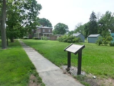
Constructed in 1833, this building was located just north of the present Main Arsenal as shown in the picture. The nearby identical Paymaster’s House was located on the south side of the Main Arsenal. Around 1880, both of these residences were . . . — — Map (db m65730) HM WM
On Bridge Street at Stearns Square, on the left when traveling south on Bridge Street.
Constructed on a site formerly occupied by Scott's Laundry, this building was originally owned by the Morgan Realty Company, a development arm of the nearby Morgan Envelope Company, one of the City's largest industries. The two-story structure . . . — — Map (db m158579) HM
Old First Church has been located in Court Square since the 17th century. It was the twentieth parish formed in the Massachusetts Bay Colony, and was gathered in 1637, the year after Springfield was founded. The first meetinghouse was erected just . . . — — Map (db m158499) HM
In the spring of 1636, a small band of early settlers from Roxbury, Massachusetts ventured up the Connecticut River to settle in Springfield, then known by its Indian name of Agawam. Together they executed an agreement which in part reads: "Wee . . . — — Map (db m158500) HM
Theodor Seuss Geisel (1904-1991) was born is Springfield, Massachusetts, and true up in the city's Forest Park neighborhood. Geisel attended and graduated for Central High School, where he developed his skill as an illustrator while serving on . . . — — Map (db m261643) HM
Naismith Memorial Basketball Hall of Fame
The Basketball Hall of Fame promotes and preserves the living history of the sport and basketball and highlights its nearly 400 inductees. The sport was invented in 1891 on the campus of Springfield . . . — — Map (db m230754) HM
Near Federal Street at State Street, on the right when traveling south.
Springfield Armory
Has been designated a
Registered National
Historic Landmark
Under the Provisions of the
Historic Sites Act of August 21, 1955
This Site Possesses Exceptional Value
In Commemorating and Illustrating
The History of . . . — — Map (db m110886) HM
Near Federal Street at State Street, on the right when traveling south.
The Springfield Armory (1794 — 1968) was the first National Armory in the United States.
It was an outstanding, innovative center for the design and production of military small arms.
Among its notable achievements are the Blanchard Lathe . . . — — Map (db m110888) HM
On State Street north of Main Street, on the right when traveling north.
This limestone building is a rare example of Art Moderne architecture in Springfield. It was designed by the Boston architectural firm of Thomas M. James Company for the Springfield Safe Deposit and Trust Company. Established in 1886, the company . . . — — Map (db m158498) HM
Near Main Street east of Court Street (Bruce Landon Way), on the right when traveling east.
[west plaque] Springfield furnished in the war of the rebellion two thousand four hundred and eighty five soldiers and sailors, the greater part of whom enlisted in the 10th, 27th, 37th, and 46th regiments. • • • They served with credit and . . . — — Map (db m158600) HM WM
On Taylor Street just south of Kaynor Street, on the left when traveling south.
The Springfield Steam Power Company was formed in 1881 by the Wason Car Manufacturing Company to supply power to company-owned blocks in the vicinity of Taylor and Lyman Streets. Work was soon begun on this three-story building which was first . . . — — Map (db m158399) HM
On Taylor Street south of Kaynor Street, on the left when traveling south.
Local architect F. R. Richmond designed this building for Edwin Stacy, a manufacturer of machinery and mill supplies. His son Frank took over the business in 1911 and served as Mayor from 1914 to 1918. The upper floors of the building were leased . . . — — Map (db m136598) HM
On Bridge Street just south of Stearns Square, on the left when traveling south.
This building was constructed to house stores and offices. It was designed by Samuel M. Green & Company, which eventually located its offices on the top floor. The company specialized in industrial architecture and engineering. It was involved in . . . — — Map (db m158495) HM
On Stockbridge Street north of Main Street, on the right when traveling north.
In 1839, Elam Stockbridge laid out this street and later constructed a series of brick buildings. This structure is the sole survivor of that row which housed both stores and residences. From 1913 to 1973, the Guenther and Handel Company, a . . . — — Map (db m158699) HM
On Fort Street north of E Columbus Avenue, on the left when traveling north.
The “Old Fort” in Early Springfield
Location ~ Fort and Main Street
William Pynchon founded Springfield in 1636.
His wooden house was constructed on this site, some 70 feet from the corner of Fort and Main Streets.
When he returned to . . . — — Map (db m304118) HM WM
Just east of here stood the first meeting house built in 1645. Past this point ran Meeting House Lane, which led to the first training field and burying ground on the bank of the Greate River. — — Map (db m304356) HM
As a "military factory," Springfield Armory was a hybrid installation, never a typical military post. During and after the Civil War, the military presence increased, with junior officers taking more of a hand in supervising production and . . . — — Map (db m107109) HM
Near Federal Street at State Street, on the right when traveling south.
To the Memory Of
George Washington
Commander-In-Chief Of
The American Army
1775 — 1785
First President of the United States
Who endorsed the location of a magazine and laboratory at Springfield in 1777, personally inspected the . . . — — Map (db m110887) HM
On Bridge Street just south of Barnes Street, on the right when traveling south.
This building replaced the Trinity Methodist Church which stood on the site from 1869 to 1922, when the congregation relocated to a more suburban section of the City. Samuel M. Green & Company designed the block, whose facade is a colorful . . . — — Map (db m158601) HM
On Main Street at Crossett Lane, on the right when traveling east on Main Street.
Union House / Chandler Hotel The Union House opened as a hotel in 1846. Two Presidents slept here, including James K. Polk, the 11th President, who stayed during a trip through the Northeastern part of the country. He was joined by his . . . — — Map (db m136695) HM
On Main Street west of Bruce Landon Way (Court Street), on the right when traveling west.
Now home to MultiBank National, this building was designed by the nationally recognized architectural firm of Peabody and Stearns. It is one of five of their known works in the Pioneer Valley. The Beaux Arts style building was erected for the Union . . . — — Map (db m158697) HM
On Worthington Street at Stearns Square, on the left when traveling north on Worthington Street.
The Italianate style Wells Block was built on the site of a lumber yard. Its construction was part of continued growth of business away from Main Street. Stores occupied its ground floor, and tenements were on the upper floors. In 1891, the . . . — — Map (db m158479) HM
During the 19th century, the Master Armorer played one of the most important roles at the Springfield Armory. He oversaw quality control measures and implemented innovative manufacturing techniques needed for the mass production of standardized . . . — — Map (db m230758) HM
On Eastern Avenue at Monroe Street, on the right when traveling north on Eastern Avenue.
Dedicated In Memory Of
Leonard A. Corbin
Springfield's First Black Firefighter
Appointed June 9, 1969 - Retired March 4, 2001
32 Years of distinguished service to the citizens of the City of Springfield
Lenny was a true . . . — — Map (db m288565) HM
On Eastern Avenue north of Monroe Street, on the right when traveling north.
This stone represents the last artifact of the former Buckingham Junior High
School building. The building was constructed on this site, 110 years ago, in 1891. It
was named for Dr. Samuel G. Buckingham, one of the city's most influential . . . — — Map (db m288563) HM
On Boston Road at Berkshire Avenue, on the right when traveling west on Boston Road.
This tree is planted in honor
of the late
John H. Murphy
November 27, 1936 - January 29, 2022
Founder of Springfield-based Eastern General Contractors, Inc., where he served as president and CEO for more than 50 years until the time of his . . . — — Map (db m288535) HM
On Boston Road at Berkshire Avenue, on the right when traveling west on Boston Road.
In memory of Pine Points veterans
who served our country in the
armed forces and to our youth whose
continued growth symbolizes the future
of our community. Donated P.P.C.C. 11-5-83 — — Map (db m288559) WM
On State Street south of Main Street, on the left when traveling south.
Constructed in 1929, the building at 95 State Street features a classical revival style of architecture. The eleven-story structure was built for the Springfield Republican as an annex to the adjacent State Building, which had been recently acquired . . . — — Map (db m136697) HM
Near Union Street south of Main Street, on the right when traveling south.
Originally the French Protestant Church, this edifice was erected with the support of Daniel Wesson, a local industrialist, to serve the small French-Canadian Protestant population in the City. In 1909, the building was given up by the French due to . . . — — Map (db m136698) HM
Near Union Street south of Main Street, on the right when traveling south.
The French Congregational Church was built in 1887, the first place of worship in Springfield to accommodate the City's growing French Protestant population. The building's vernacular is a Victorian Gothic style of brick and Longmeadow brownstone, . . . — — Map (db m136694) HM
Howard Street School The Howard Street School, designed by the local firm of Kirkham and Parlett, formerly stood on the MGM Springfield site. It was one of the first of many public buildings the firm, formed in 1904, was responsible for in . . . — — Map (db m158392) HM
On Mill Street at Main Street, on the right when traveling east on Mill Street.
Near this spot Lieut. Thomas Cooper and Constable Thomas Miller were killed by the Indians just prior to the burning of Springfield October 5, 1675 — — Map (db m304692) HM WM
On State Street south of Main Street, on the left when traveling south.
The Massachusetts Mutual Life Insurance Company commissioned Springfield's first steel frame skyscraper, built in the Classical Revival style. It was completed in 1908 and caused a controversy over its "excessive height" of 125 feet. A law . . . — — Map (db m136696) HM
On Main Street at State Street, on the right when traveling east on Main Street.
Organized in 1851, the Massachusetts Mutual Life Insurance company grew to become one of Springfield's largest businesses. It was begun by George Rice and Alfred Lambert to assure annual dividend life insurance. By the early twentieth century, . . . — — Map (db m137171) HM
The Springfield Armory was built in 1895
for the Massachusetts Volunteer Militia.
The building was designed by architects
Robert Wait and Amos Cutter from
Boston, who were responsible for many
county courthouses and state buildings in
Eastern . . . — — Map (db m127593) HM
On State Street north of MGM Way, on the right when traveling north.
United Electric Co. Building In 1912 the United Electric Company office building was completed by local builder Casper Ranger. The Beaux Arts brick and limestone building was designed by Boston architect Thomas M. James. The United Electric . . . — — Map (db m158394) HM
On State Street just north of MGM Way, on the right when traveling north.
The first electric lights in Springfield were installed inside a downtown factory in 1881; the first local streetlights went up in 1889; and the trolley system was electrified in 1890. The United Electric Light Company was formed to meet the . . . — — Map (db m158395) HM
The YWCA building, previously located at 22-30 Howard Street, was built in 1909. It was designed by local architect Eugene C. Gardner in the Renaissance Revival style. The building consolidated the boarding and educational functions of the YWCA, . . . — — Map (db m128267) HM
On Main Street west of Sykes Street, on the left when traveling west.
This bell, consecrated in the name of
Saint Ann in 1914 A.D.
and for many years thereafter
called the faithful to glorify God in the
Church of Saints Peter and Paul
Three Rivers, Massachussetts — — Map (db m199386) HM
On New Boston Road (Massachusetts Route 57) at Clubhouse Road, on the right when traveling west on New Boston Road.
In Memory of
Gordon Hall
First American Board
Missionary to
India, 1812 - 1826
Born in
Tolland, April 8, 1784
Died in
Doorlee D’hapoora
March 20, 1826 — — Map (db m97475) HM
On New Boston Road (Massachusetts Route 57) at Clubhouse Road, on the right when traveling west on New Boston Road.
Tolland Honor Roll
Moore, Raymond J. *
Messenger, Earl B. *
1917 --- 1918
Balch, Raymond • Clark, Jr. Ernest • Hanauer, Henry • Johnson, Henry B. • Rowley, Thomas
1940 --- 1960
Alaconis, Donald J. • Alaconis, Edward C. • . . . — — Map (db m97473) WM
On Park Street east of Van Dean Avenue, on the right when traveling west.
Dr. Mahlon Loomis 1826-1886 Aerial Signals Pioneer In 1850, Dr. Mahlon Loomis, dentist, inventor and wireless communications pioneer, lived with his wife, Acshah Ashley, in a nearby cottage at 232 Park St. It was here that he began experiments in . . . — — Map (db m195317) HM
On Park Avenue (Massachusetts Route 20) at Main Street, on the left when traveling east on Park Avenue.
Through this place passed General Henry Knox in the winter of 1775 – 1776 to deliver to General George Washington at Cambridge the train of artillery from Fort Ticonderoga used to force the British Army to evacuate Boston. Erected by the . . . — — Map (db m24008) HM
On Park Avenue (Massachusetts Route 20) at Main Street, on the left when traveling east on Park Avenue.
Here encamped Oct. 30 and 31, 1777, Gen. Riedesel and his Hessian soldiers on their way to Boston after Burgoyne’s surrender at Saratoga. — — Map (db m24075) HM
On Park Street at Hanover Street, on the right when traveling west on Park Street.
Only known solid brick salt box house of its period in the United States. At present, the only national historic site in the town of West Springfield – founded 1636. Preservation by Ramapogue Historical Society since 1903. — — Map (db m195172) HM
On Park Avenue at Elm Street, on the left when traveling east on Park Avenue.
On September 11, 2001, terrorists hijacked four planes. Two were flown into the World Trade Center Towers, leading to their collapse. One was flown onto the Pentagon. The other crashed in Shanksville, Pennsylvania.
In memory of the 2,999 victms . . . — — Map (db m195316) HM
On Park Street at Main Street, on the left when traveling west on Park Street.
Dedicated to the
Glory of God
And to the Memory
Of Our Citizens
Who Gave Their Lives
In the Service
Of Their Country
In World War II
1941 — 1945
Erected by the Citizens of
West Springfield
MCML
Pro Deo Et . . . — — Map (db m195170) WM
On Park Street at Elm Street, on the left when traveling west on Park Street.
Dedicated to those West Springfield residents who served in Vietnam with special recognition to the following who gave their lives…
Joel H. Chapin · Richard N. Gauthier · Daniel L. Grover · Raymond G. Masse · Alan L. Matte
( back . . . — — Map (db m195315) WM
On Southampton Road (U.S. 202) 0.2 miles north of Egleston Road, on the right when traveling north.
1941-1945 Fortitude et Courage La Bataille est finis In honor and memory of all who served in the 104th Infantry Regiment during World War II — — Map (db m56059) WM
On Southampton Road (U.S. 202) 0.8 miles south of Falcon Drive / Summit Lock Road, on the left when traveling south.
Presented to the 104th U.S. Infantry Veterans Association, A.E.F., Nov. 8, 1937 by Mrs. Sadie B. Knox and heirs, in memory of her father, Vincent E. Barnes Born Oct. 9, 1849, Died Dec. 4, 1933 A life long resident and distinguished citizen of . . . — — Map (db m56058) HM WM
On Main Street (U.S. 20) at U.S. 202, on the right when traveling east on Main Street.
Through this place passed
General Henry Knox
in the Winter of
1775 - 1776
to deliver to
General George Washington
at Cambridge
the train of artillery
from Fort Ticonderoga used
to force the British Army
to evacuate . . . — — Map (db m23754) HM WM
On Elm Street (U.S. 202) at Court Street, on the left when traveling south on Elm Street.
Believed to be one of the mileposts erected by Elijah Bates “From Springfield Court House to Chester Factories,” this marker stood at 80 Main Street for about 150 years. Lawyer Bates, principal owner of the Eighth Mass. Turnpike, built . . . — — Map (db m24502) HM
On Court Street (U.S. 202) at Holland Avenue, on the right when traveling east on Court Street.
A friend of Liberty and his country Soldier in the American Revolution Armorer to the 18th Mass. regiment Built armory at Mt. Tekoa circa 1765 Made muskets for the patriot cause This was the site of his home and blacksmith shop circa 1764 to 1783 . . . — — Map (db m24077) HM
Near Southampton Road (U.S. 202) 0.8 miles south of Falcon Drive / Summit Lock Road, on the left when traveling south.
Upper Plaque "For greatest fighting spirit and self sacrifice during action of April 10, 12, and 13, 1918, suffering from very heavy bombardments and attacked by very strong German forces the 104th Infantry succeeded in preventing their . . . — — Map (db m56060) WM
On Court Street (U.S. 20) at Elm Street (U.S. 202), on the left when traveling east on Court Street.
Westfield honors the memory of her sons who have fallen in defence of Liberty Union and Independence 1861 to 1865. --------------- Erected 1871 — — Map (db m24356) HM
On Boston Road (U.S. 20) near Main Street, on the right when traveling east.
Through this place passed General Henry Knox in the winter of 1775 – 1776 to deliver to General George Washington at Cambridge the train of artillery from Fort Ticonderoga used to force the British Army to evacuate Boston. Erected by the . . . — — Map (db m24014) HM
On Main Street (Massachusetts Route 202) north of Maple Street, on the right when traveling north.
Honor Roll
To Its Sons and Daughters
Who Answered the Call of Country in Its Hour of Need
Belchertown, in Grateful Memory,
Dedicates this Memorial at Its Bicentennial
September 23, 1961, A.D.
Where’er they sleep in distant clime . . . — — Map (db m199430) WM
On Main Street (U.S. 202) 0.1 miles north of Maple Street & Jabish Street (U.S. 202), on the right when traveling north.
[Front plaque]
Dedicated to
the
memory of those
who fought and died
from this town in the
Rebellion 1861 – 1865
and all soldiers now
citizens of Belchertown.
Also to the memory of
all those from
Belchertown who served . . . — — Map (db m198096) WM
On Main Street (Massachusetts Route 202) north of Maple Street, on the right when traveling north.
Belchertown
Honors Our Veterans
Who Served in the
Midle East Wars
Phillip Leab · Daniel Bellerose · Matthew Aliberti · Kevin Bowen · Stephen Gallant · Ronald Ryczek · Patrick Loftus · Vincent Engel · Bernard Schliemann · Matthew Blais · . . . — — Map (db m199391) WM
On Main Street (Massachusetts Route 202) north of Maple Street, on the right when traveling north.
Belchertown
Honors
The Men and Women Who Served Their Country
During the Vietnam Period
( back )
Anderson, Robert K. · ★Austin, Michael P. · Austin, Paul F. · Barnes, Frederick W. · Barrett, Warren R. · Barry, William P. Jr. · . . . — — Map (db m199388) WM
On Main Street (Massachusetts Route 10) at Campus Lane, on the right when traveling south on Main Street.
Easthampton
1869
erects this
tower memorial
to these, her sons who
died for their country
during the Great Rebellion
Maj. Gen. George Crockett Strong, Maj. in U.S. Army and Maj. General of Vol's. A student at Williston Seminary. . . . — — Map (db m198093) WM
On Park Street at Main Street, on the left when traveling north on Park Street.
Vietnam
1959 — 1975
PFC John J. Rabideau U.S. Army 7 July 1948 4 Dec. 1967
L/Cpl. Bruce W. Monska U.S. Marines 21 March 1949 2 May 1968
Sgt. Charles J. Robinson U.S. Army 4 April 1947 16 Jan. 1969
CWO George F. Lapan . . . — — Map (db m194992) WM
On Park Street at Main Street, on the left when traveling north on Park Street.
In Honor of Those who Served
in
1917 The World War 1918
These Gave Their Lives
Charles Bromley · Michael C. Cameron · Abner Laurens Clark · Leo Courtemanche · Louis Cummings · Leonard Dalton · Joseph J. Dineen · Joseph Gilarowski · . . . — — Map (db m195167) WM
On Park Street near Main Street, on the left when traveling north.
World War II
In honor of those who served
1941 – 1945
These made the Supreme Sacrifice
Beyer Edward · Bien Carl · Bostic Joseph Jr. · Boucher Raymond · Bozek Walter · Bridges Ralph · Brooks Albert · Campbell John · Carver Samuel · Chrabasczc . . . — — Map (db m195002) WM
The major industries established in Florence during the 19th century were founded by reform-minded individuals who championed progressive causes throughout their lives. Their success in business was matched by their generosity in giving. Many of the . . . — — Map (db m168919) HM
Florence, or Broughton’s Meadow as it was originally called, was one of America’s early manufacturing centers. In 1837, Samuel Whitmarsh established the area’s first silk mill along the Mill River. Importing silk worms fed on homegrown mulberry . . . — — Map (db m65761) HM
Present-day Florence is the site of one of the most active centers of the anti-slavery movement in America. In 1842, members of the Northampton Association of Education and Industry, among them Samuel L. Hill and George Benson, established a utopian . . . — — Map (db m168866) HM
The Florence Eagles were once one of the legendary teams of early baseball history. In 1865, as the Civil War drew to a close, the Army of the Potomac had its own championship team composed mainly of youths from Western Massachusetts. One of the . . . — — Map (db m65746) HM
On Russell Street (Massachusetts Route 9), on the right when traveling east.
Indian land called Norwottock. Settled in 1650 by families from Hartford. The Regicides Generals Goffe and Whalley were concealed for fifteen years in the Pastor's house. — — Map (db m48757) HM
On North Lane (Massachusetts Route 9) south of Cemetery Road, on the right when traveling south.
Indian land called Norwottock. Settled in 1650 by families from Hartford. The Regicides Generals Goffe and Whalley were concealed for fifteen years in the Pastor's house. — — Map (db m298016) HM
On Mountain Road at Skinner State Park Road on Mountain Road.
The park’s westernmost peak, Mt Holyoke, was the site of North America’s first summit house (1821) and the state’s first mountain tramway (1854). Located in the towns of Hadley, South Hadley, Amherst, Belchertown, and Granby, the two parks were . . . — — Map (db m65741) HM
On Russell Street (Massachusetts Route 9) at Goffe Street, on the right when traveling east on Russell Street.
Hooker School
Named in Honor of
Major General Joseph Hooker
Born at Hadley, Mass., Nov. 13, 1814
Educated at Hopkins Academy
Cadet U. S. Military Academy 1833 - 37
Served Gallantly in Mexican War
Commander of Army of The Potomac . . . — — Map (db m194733) HM
On Russell Street (Massachusetts Route 9) near Goffe Street, on the right when traveling east.
Hopkins Academy
One of the oldest secondary schools in the country; founded in 1664 through the bequest of Governor Edward Hopkins (1601 – 1607); first classes held at various sites throughout the town including West Street, North Hadley and . . . — — Map (db m194751) HM
On Russell Street (Massachusetts Route 9) at Goffe Street, on the right when traveling east on Russell Street.
Established in May 2014 Commemorating the 350th anniversary of Hopkins Academy founded in 1664. The bell in the gazebo hung in 1894 in Hopkins Academy which was then located in the Russell School building. The rock that holds this plaque was part . . . — — Map (db m194752) HM
On River Drive (Massachusetts Route 47) 0.3 miles north of Huntington Road, on the left when traveling north.
Preservation Works!
The Porter-Phelps-Huntington Historic House Museum
This property which is listed in the state register of places, has received a matching grant from the Massachusetts Historical Commission, Secretary of the Commonwealth William . . . — — Map (db m194755) HM
On Main Street (Massachusetts Route 9) at Kingsley Avenue, on the left when traveling north on Main Street.
On this site David and Daniel Hayden built Haydenville's first factory, a cotton mill, in 1809. Subsequent owners manufactured power looms and other industrial equipment. In 1828 the mill was enlarged and converted for the manufacture of buttons, . . . — — Map (db m263790) HM
On Russell Road (U.S. 20) at Route 112, on the right when traveling north on Russell Road.
Erected by
the citizens of this town
in honor of
her patriotic men and women
who served their country
in the time of war
to the dead-a tribute
to the living- a memory
to posterity- an emblem of loyalty
to the flag of . . . — — Map (db m111665) WM
On Huntington Road (Massachusetts Route 112) 0.4 miles north of Kimball Road, on the right when traveling north.
( upper left inset )
A Wild River
Splashing over waterfalls, nourishing farmland and flowing past deep forests and historic New England towns, the Westfield is one of America's great rivers. Over 78 miles of its branches and . . . — — Map (db m157956) HM
On Bridge Street (Massachusetts Route 9) at Parsons Street, on the right when traveling west on Bridge Street.
Dedicated to the
Honor and Sacrifice
Of Our Men and Women
Who Served Our Country
In
All
Wars
Erected by
B.P.O.E.
No. 997
Dedicated June 9
1985 — — Map (db m194967) WM
Near Main Street (Massachusetts Route 10) at Masonic Street, on the right when traveling east.
To perpetuate the memory of Brigadier General Casimir Pulaski an American Revolutionary War Hero, who, from wounds received at the siege of Savannah, Georgia, died on October eleventh, 1779.
This memorial is erected in testimony of . . . — — Map (db m138431) WM
On Pleasant Street (U.S. 5) at Main Street ( Route 9), on the right when traveling south on Pleasant Street.
1872 Born Plymouth, Vt.
1895 Graduate, Amherst College
1897 Admitted Mass. Bar Assoc.
1898 City Councilor, N'ton
1901 City Solicitor, N'ton
1906, 1907 State Rep, Mass.
1909, 1910 Mayor, City Of N’Ton
1911--1914 State . . . — — Map (db m194792) HM
On Pleasant Street (U.S. 5) at Main Street ( Route 9), on the right when traveling south on Pleasant Street.
Orators ... are usually flattered by having a numerous audience, but I am ashamed of the one before me.... Are there men to whom, the death of their fellow beings is a spectacle of pleasure, an object of curiosity? So preached Father . . . — — Map (db m194800) HM
On Main Street (Massachusetts Route 9/10) east of Masonic Street, on the right when traveling west.
This building is the remaining portion of the old
Draper Hotel
The first inn on this site was built by Asabel Pomeroy in 1792. Purchased by Oliver Warner in 1821 it became the Warner House, a celebrated stop on the Boston and Albany . . . — — Map (db m230495) HM
On Pleasant Street (U.S. 5) at Main Street ( Route 9), on the right when traveling south on Pleasant Street.
Northampton is the "Shire Town" or county seat for Hampshire County. When it was officially established in 1662, Hampshire County became the fifth county of the Massachusetts Bay Colony. The county originally included all of Western Massachusetts. . . . — — Map (db m194797) HM
On Main Street (Massachusetts Route 9) near Gothic Street, on the right when traveling south.
Jonathan Edwards is often remembered as the stern Puritan who preached fire and brimstone sermons such as his notorious "Sinners in the Hands of an Angry God." Yet Edwards was also America's preeminent thinker of the 18th century. Besides being a . . . — — Map (db m194872) HM
On Bridge Street (Massachusetts Route 9) at Parsons Street, on the right when traveling west on Bridge Street.
Planted in honor of those who lost their lives in the tragic events on September 11, 2001
The American Liberty elm was named after The Liberty Tree" : Our Country's first Symbol of Freedom. On the morning of August 14, 1765, the people of . . . — — Map (db m194969) HM WM