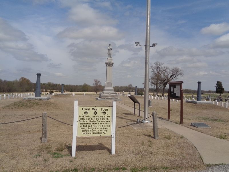
In 1870-71, the victims of the attack on Fort Blair and the Battle of Baxter Springs were disinterred from a site near the fort and reinterred in this newly designated national cemetery plot, officially National Cemetery #2. — — Map (db m171037) HM
In a field to the east, Blunt's military band wagon overturned while trying to escape the guerillas. The bandsmen were shot and their bodies were burned in the wagon. — — Map (db m170671) HM
The first bank in Baxter Springs was the Bank of Baxter also called the Crowell Bank. It was established in 1870 and did business in this building. H. R. Crowell, the founder, was the second mayor of Baxter Springs. In May of 1876, Jesse James and . . . — — Map (db m37531) HM
In the late 1880s, this building was constructed by W. H. Horner, and in it he established the Drovers' and Farmers' Bank. The Bank was purchased by John M. Cooper and J. N. McDonald, who changed the name to the Traders' Bank. They were later . . . — — Map (db m37502) HM
In 1866, a small log school building was built on this site, with benches and desks hewn from logs. The first teacher was Miss Lillie Van Epps. It was a subscription school, which was maintained, and the teacher paid with tuition from the students. . . . — — Map (db m80341) HM
Fort Blair, constructed as a garrison for soldiers guarding the Military Road, was attacked by rebel forces of William Quantrill on Oct. 6, 1863.
Although greatly outnumbered, Lt. James Pond and men from the 3rd Wisc. Cav. and Kans. 2nd Colored . . . — — Map (db m37838) HM
This is a replication of the blockhouse which records tell us was in the center of the encampment. The original blockhouse measured 16 feet square and was constructed of logs. It was built to store equipment and supplies. Reports indicate that it . . . — — Map (db m37621) HM
The breastworks that enclosed Ft. Blair measured 80 feet by 100 feet. A trench, called a rifle pit, encircled the breastworks on the inside. The dirt that was extracted to create the rifle pits was then piled outside the walls to provide a . . . — — Map (db m37599) HM
The west wall of the breastworks had been removed the day before the attack in order to enlarge the encampment to make room for more than 100 additional cavalry troops which had arrived under the command of Lt. Pond. — — Map (db m37623) HM
The Illinois Cash Store, a grocery and dry goods store, was constructed on this site in 1868 by John M. Cooper who came to Baxter Springs from Illinois. In 1886, he constructed a new brick building one block south and moved the business. in 1900, . . . — — Map (db m52061) HM
The Indiana Hotel, later renamed the Indiana House, was constructed on this site around 1870.
Christian Null acquired the Indiana House in 1881 and operated the business until its closing in the late 1890s. In 1900, the present building was . . . — — Map (db m37533) HM
In the spring of 1849, John Baxter, his wife and 8 children moved to this site and built an inn and general store and offered food and lodging to travelers who passed along the Military Road. Baxter was a colorful character -- a speculator, . . . — — Map (db m37598) HM
In the spring of 1849, John Baxter, his wife and 8 children moved to this site and built an inn and general store and offered food and lodging to travelers who passed along the Military Road. Baxter was a colorful character - a speculator, business . . . — — Map (db m272261) HM
This grand building was entered on the National Register of Historic Places in 1976. Built in 1872, it was intended to be the county courthouse, but was never used for that purpose. Through the years, the building has served as a city hall and a . . . — — Map (db m80350) HM
This small bridge is the last of its kind in Cherokee County. Given to the historical society by the county commissioners, it was moved to this site in 1994 from the northwest corner of the county. — — Map (db m80332) HM
This log cabin was built east of the Lowell Cemetery in the late 1870's. R.A. Hibbard built it as a home for his brother-in-law's family. Kent Lynch purchased the property and donated the cabin to the historical society in memory of Marsha Moncrief . . . — — Map (db m80219) HM
In 1872, the Mayor of Baxter Springs, J. R. Boyd, shot and killed C. M. Taylor, marshal, near this spot. Bad blood had existed between the two for some time.
The marshal approached Boyd to serve him a warrant for arrest on an assault charge. . . . — — Map (db m37437) HM
Henry and Louisa Ohlen purchased this property in February 1878 and opened Ohlen's Restaurant and Bakery. Among their offerings were ice cream and oysters which were advertised "in their proper seasons." The Ohlen's [sic] also offered a day . . . — — Map (db m37505) HM
J. P. Opperman, a native of France, came to Baxter Springs in 1871 and established the Opperman Harness and Saddle Shop located on this site. The building is still here, but lies beneath the present facade. Opperman's was one of the most successful . . . — — Map (db m37471) HM
Built in 1930 by the Independent Oil
and Gas Company, this Tudor
Revival style gas station was
purchased by Phillips 66 Petroleum
Company the same year. The
original "house" style brick building
was modified in the 1940s to the . . . — — Map (db m37388) HM
In May of 1893, the Polster Brothers, Charles, John and Ed, and their mother, Elizabeth Polster, had a grand opening for their new dry goods store. The public was entertained with music by an Italian harpist, and the building was lavishly decorated . . . — — Map (db m37503) HM
Near this site, Quantrill's men attacked and killed several men from the fort engaged in target practice. Among them were Johnny Fry, an Army scout who had earlier won fame as the first Pony Express rider, and Lt. Ralph Cook, officer in charge of . . . — — Map (db m80331) HM
Baxter Springs' economy was driven through two major periods of economic growth. First, as a cow town, thanks to its proximity to Texas and easy access to eastern markets. The second, as part of the lead and zinc mining region, which flourished in . . . — — Map (db m174250) HM
William C. Quantrill, a former Kansas school teacher, headed a guerilla army which had committed many outrages around Lawrence and Kansas City, one being the Lawrence Massacre. Quantrill received a commission of Colonel, supposedly either from . . . — — Map (db m80834) HM
A gushing spring, largest of many along Spring Branch, once flowed here. Early pioneers, Osage Indians, and military personnel stopped to camp here and drink the mineral waters, believed to have curative powers. During the Victorian Era, when the . . . — — Map (db m80336) HM
The Osage at Baxter Springs
The Osage once controlled a vast territory in the center of North America. In the mid-1600s, the tribe moved to the area around Baxter Springs. The area was important to the Osage because, for the tribe, it was . . . — — Map (db m174252) HM
A giant elm, it's branches spreading nearly 100 feet, grew here on the bank of Spring Branch. It shaded Fort Blair's mess kitchen during the Civil War and later was infamous as the site of vigilante justice. As many as seven horse . . . — — Map (db m80339) HM
The Baxter Springs brewery was built on this site in 1870 by Edward Zellekin, a German immigrant who knew there would be a demand for his product in the booming cattle town. The massive building was constructed of brick and yellow . . . — — Map (db m80218) HM
In Memory of
All American Veterans
This memorial honors all American Veterans
who although separated by generations shared a common
undeniable goal to protect our country's freedoms.
In war and in peace they have placed . . . — — Map (db m73093) WM
To the loving memory of those men and women who gave their lives in all past wars and to all veterans who served our great country we dedicate this tank
We thank you for your sacrifices
This M-60 forty five ton Army tank was donated by . . . — — Map (db m80333) WM
In 1870, the city marshal, H. C. Seaman, was called to the Wiggins House, a hotel/saloon located on this corner. The marshal intervened in an alteration between Mr. Wiggins who was the proprietor, a saloon girl, and a Texas cowboy. Nine shots . . . — — Map (db m80346) HM
This engine is one of the first internal combustion engines used by the Missouri Pacific Rail Road. It ushered in a new form of motive power that eventually replaced the steam engine.
This engine was last used at the Mackie-Clemens Mine #22 in . . . — — Map (db m34696) HM
This wooden frame depot is typical of most small town stations of this era. The depot and water tower was originally built in the 1880s and was located about ¼ mile south. The depot was torn down and moved in 1941. Due to the shortages caused by . . . — — Map (db m34676) HM
This Caboose was used by the Southern Pacific Railroad. Train crews lived in the caboose as the train traveled across the country. The bay window style allowed the crew to watch the train for any problems while riding. This caboose is on loan to . . . — — Map (db m34710) HM
Robert Alexander Long in 1875 established his first lumber yard at this site. Fifty years later Long-Bell lumber company was the largest lumber company in the world.
www.ralonghistoricalsociety.org — — Map (db m96967) HM
The Cherokee Indians were given this land in an 1835 treaty becoming the Cherokee Neutral Lands. Kansas was established as a state in 1861. The territory became Cherokee County named for the Cherokee Indian Nation.
During the Civil War the . . . — — Map (db m60770) HM
Unique railroading history is on display before you. A three-way interlocking railway crossing.
The crossing, formerly located in the northern part of Columbus, was donated to the City of Columbus by the Burlington Northern Railroad. At the . . . — — Map (db m11593) HM
In 2001, members of the community joined with the Galena Chamber of Commerce to donate a block of the downown Route 66 main street to construct a park for everyone to enjoy.
Route 66 Howard "Pappy" Litch Park
The Oldest Mining Town in . . . — — Map (db m43047) HM
Formerly, modern-day Galena was a wooded area of the Kansas
Ozarks. By 1835, it was part of the Cherokee Neutral Lands, though
Euro-Americans quickly settled the region after Kansas became a state
in 1861. Sharing a border with slave-state . . . — — Map (db m161630) HM
Named for the ore it produced, Galena lead mining was the largest industry in our history, starting in 1873 and continuing until 1973. The mining and smelting required 3 railroads, 65 crushers, 2 smelters and 3 sludge mills to handle the ore . . . — — Map (db m43035) HM
Built in 1939 out of native stone, this filling station served
travelers for decades under the ownership of Logan Thompson.
It closed shortly after 2000, but renovations by Aaron
Perry started in 2018, reopening as Gearhead Curios in 2019. — — Map (db m272259) HM
As an important mining town, Galena had
numerous mines and smelters, but none
was more important than the Eagle-Picher
smelter plant north of the pre-1940s Route 66
alignment. The facility operated from around
the late 19th century until 2004 . . . — — Map (db m161632) HM
In 2001, members of the community joined with the Galena Chamber of Commerce to donate a block of the downtown Route 66 main street to construct a park for everyone to enjoy. — — Map (db m272254) HM
For many years, a large garage/service station stood at this location.
The owner, Howard "Pappy” Litch, was an avid Galena historian.
"Pappy” spent much of his life promoting his hometown and saving
its history. To honor him for . . . — — Map (db m161633) HM
Geological remnants of Mississippian times are found in the limestone cave region of the 55 square mile Ozark Plateau in the very southeast corner of Kansas. The cherty limestones of the area were developed in marine environments during the late . . . — — Map (db m61154) HM
This 1.2-mile section of roadbed is the most intact section of the original U.S. Highway 66 (Route 66) in Kansas. It was first paved around the turn of the century using macadam made from the waste products of the nearby mines. Prior to its federal . . . — — Map (db m170666) HM
Dedicated to the Glory of God
and to the Spirit of
Sacrifice and Honor of the
Men and Women of
this community who served
our country in all wars
Lest we forget they have
given all for the principles
of democracy
Freedom of . . . — — Map (db m61152) WM
There is plenty to do while visiting Galena, aside from Cars
on the Route, starting right here in Howard "Pappy Litch
Memorial Park. Named for a local historian, the park was
once a federal weigh station. This official Route 66 . . . — — Map (db m161631) HM
Headquartered in Fort Scott, Union Major General James G. Blunt was the highly recognized commander of the District of the Frontier. In 1863, Blunt decided his force needed to be closer to the gathering Confederate forces in the South and headed out . . . — — Map (db m170743) HM
In less than 14 miles, this byway connects 3 towns, each with its own American success story.
The towns that dot Kansas Historic Route 66 were each poised for great success at the time the highway was designated in 1926. Galena was a major . . . — — Map (db m81118) HM
When Route 66 first gained federal status in 1926, it traveled over Kansas roads already paved.
At a time when hard-surfaced roads were a rarity in Kansas, Cherokee County was an exception. Prior to the turn of the century, engineers had . . . — — Map (db m81117) HM
The people of the Cherokee Nation left a lasting legacy to this corner of the State.
The 1836 Treaty of New Echota forced the removal of the Cherokee Nation from lands east of the Mississippi to the new Indian Territory. In addition to the . . . — — Map (db m81141) HM
You stand just miles north of one of Kansas' oldest highways: the Black Dog Hunting Trail.
In order to provide a supply route between seasonal hunting grounds, the indigenous people of the Osage Nation blazed a trail in the first decade of . . . — — Map (db m81145) HM
Baxter Springs is located on the Old Military Road connecting Fort Leavenworth and Fort Scott in Kansas Territory to Fort Gibson in Indian Territory and Fort Smith, Arkansas. The city initially served as a rest stop for wagon supply trains and their . . . — — Map (db m170736) HM
The waters of the Spring River and its tributaries have shaped this land and its settlement.
The Spring River and the waters that feed it, such as Brush, Shoal and Short Creek, carve their way through this corner of Cherokee County. For . . . — — Map (db m81100) HM
Rainbow Curve Bridge constructed in 1923 over Brush Creek. Only remaining Marsh Arch Bridge on Route 66. Listed on the National Registry March 10, 1983. — — Map (db m52060) HM
From wagon trails to rivers, railroads to highways, the ease of transporting people and goods has shaped the settlement of Kansas. At Riverton, two paths from different eras, now Historic Byways, cross. The Old Military Road passes along Kansas' . . . — — Map (db m170681) HM
The City of Treece, located ½ mile west of Hwy. 69 was founded on February 26, 1918 as a result of mining operations in the early 20th century. During prime mining industry production; Treece, neighboring Picher, Oklahoma and several other small . . . — — Map (db m82092) HM
This dipper bucket will hold 40 cubic yards of dirt and rock. It was donated by the Peabody Coal Company from their Roger County Mine #2 near Vinita Oklahoma. The dipper came off a Model 5561 (Marion) Coal Shovel. The weight of the dipper, as it . . . — — Map (db m39741) HM
With the discovery of coal in Cherokee and Crawford Counties in the late 1860's, thousands came to work the mines. Some came from American towns and cities but most were immigrants from Europe. Over fifty nationalities settled in this area. Many . . . — — Map (db m39738) HM
In Grateful Memory of All
Those Who Served Their Country.
Star Cemetery
Fred Fry • William Druit • Pete Bond
James Geddes • James Huntsinger
John Marietta • Joe Marietta
Dalla Creekmore • Julian Englebright
Charles Stout • . . . — — Map (db m39768) WM
History
Company 788, CCC, was formed at Camp Whiteside, Fort Riley, Kansas, May 19, 1933. The company was made up of Kansas boys, the largest percentage coming from the eastern part of the state.
After conditioning at Fort Riley, the . . . — — Map (db m50189) HM
We dedicate this monument to the 3.5 million men of the Civilian Conservation Corps. We celebrate their legacy of accomplishments they left for the future to enjoy.
This is the home of Camp Farlington, Co. 788th "Fire Devils" SCS-10-L, who built . . . — — Map (db m50187) HM
Another advantage the Civilian Conservation Corps offered to its enrollees was the chance to further their education. In their spare time, they could enroll in classes, such as radio operator and maintenance, surveying, photography, leather works, . . . — — Map (db m50207) HM
By 1936, the progress of building the dam was greatly accelerated with the arrival of new heavy equipment. The men now had excavators, dump trucks, caterpillar tractors, box sleds, and a pull-type grader.
The CCC camp had storage sheds for . . . — — Map (db m50234) HM
Proof of how hard times were during the Great Depression, this CCC recruiting poster depicts a young man wearing a clean, pressed uniform with a plate of food. Another incentive to enroll into the CCC was a $30.00 a month salary with $25.00 . . . — — Map (db m50192) HM
"We used mules and dump wagons before we got dump trucks," said Stanley Dolinar.
Prior to 1935, the majority of earth was moved by mule teams pulling slip buckets and wagons.
On display here is a pair of slip buckets actually used to . . . — — Map (db m50235) HM
This lake constructed
by the
United States
Department of Agriculture
Soil Conservation Service
Civilian Conservation Corps
cooperating with Kansas State
Forestry-Fish-Game Commission — — Map (db m50236) HM
The story of the Civilian Conservation Corps cannot be told without knowing the tale of the times from which it was created. The stock market crash of 1929, which led to the Great Depression coupled with the lack of soil conservation enabled the . . . — — Map (db m50186) HM
You Are Here! The Water Tower. Rumor had it that whoever had the job of testing and chlorinating the drinking water in the tower received more than his share of ribbing from the men. The only recorded time of discontent was over the sulfur . . . — — Map (db m50233) HM
The 788th Co. was nicknamed the Fire Devils because of its reputation for putting out prairie fires while stationed at Camp Ruteledge in Minnesota. The nickname remained with the company throughout service. The men were proud of their reputation . . . — — Map (db m50210) HM
The Farlington project started with a creek bed surrounded by trees and brush that had to be cut and hauled away. In fact, 90 percent of the work to build Crawford State Lake was done by hand. As one volunteer claimed, "You worked, and you worked . . . — — Map (db m50190) HM
Moved to present location
September 12, 2012
Designed for applications that require blasts of air for long distances. Used in coal mining industry to force fresh air into the shafts. — — Map (db m72361) HM
Moved from Chicopee to present location
July 19, 2012
The hoist had cables on the drum that were used to raise and lower coal cars from the mine, Circa Late 1800s-Early 1900s — — Map (db m72362) HM
Used in strip-mining operations to remove the overburden of soil from coal seams.
Owned by Wilkinson Coal Company
Donated by Wendell & Lynda Wilkinson
Dedicated January 13, 2013 — — Map (db m72353) HM
Constructed by John Nepote with help of Ray Hamblin, Melvin Patrick and a host of friends and volunteers. Historic artifacts (Angels and Sacred Heart) are from St. Philip Neri Catholic Church which was located in Franklin from 1915-2004. The . . . — — Map (db m36834) HM
On this site stood the original
Franklin Grade School and Playground
1907
This bench is made from a marble
window ledge from the 2 story brick
Franklin School House — — Map (db m36761) HM
Originally there were 3 school buildings in the community. This bell sat atop the large two story, eight room brick building that was originally the high school and later became the grade school. The schools were in operation from . . . — — Map (db m36742) HM
Constructed in 1936 with federal funding assistance, the Franklin Sidewalk connects two rural mining communities in Crawford County - Franklin and Arma. The 3' wide sidewalk stretches 1.7 miles. It has become well known as the "longest sidewalk . . . — — Map (db m72352) HM
owned and operated the Pritchett Insurance and Real Estate Agency in Pittsburg, Ks. for more than 50 years.
This park is one of the results of a trust they established with a mission to improve the quality of life in Pittsburg and Crawford . . . — — Map (db m36831) HM
Honoring All Who Served
"We pledge allegiance to the flag
of the United States of America
and to the Republic for which it stands,
one nation under God,
indivisible, with liberty and
justice for all."
The City of . . . — — Map (db m117426) WM
This Flag symbolizes Liberty and Justice for all.
The John F. Derby Post No. 43 Frontenac American Legion is proud to display and maintain this flag for all those who died defending it and those who live under it. — — Map (db m63690) WM
To show our appreciation to the U.S. military men and women, past, present and future, for their sacrifices, dedication and service to our country. — — Map (db m71511) WM
[Honor Roll of Names on Black Granite]
April 15, 1995
This UH-1H "Huey" helicopter was donated by Department of the Army and Kansas Army National Guard to Girard Veterans of Foreign Wars Post 7479 through the efforts of All American Post . . . — — Map (db m36946) HM WM
This flag is lifted high and flies gallantly above this memorial in honor of those who served from those who care.
May God bless you all. — — Map (db m50133) WM
To the loving memory of those men and women who gave their lives in all past wars and to all veterans who served our great country, we dedicate this memorial as a symbol of your sacrifices. — — Map (db m36929) WM
503 entries matched your criteria. Entries 101 through 200 are listed above. ⊲ Previous 100 — Next 100 ⊳