Near Rockport Road 1 mile east of South Lehigh Gorge Drive.
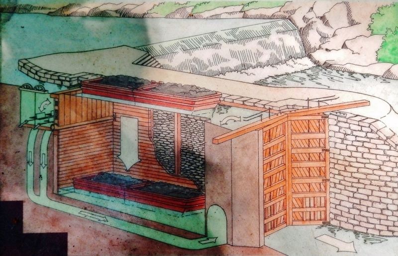
”On June 10, 1838, a boat laden with forty tons of merchandise was carried through the Lehigh navigation from Mauch Chunk to White Haven in fourteen hours, and drawn by one set of horses, and that the locks on said navigation are of a capacity . . . — — Map (db m153403) HM
On East Main Street at Spring Street on East Main Street.
Marker front:
1861 - 1865
Our country's crisis
Erected
by the citizens of
Weatherly
and vicinity
A.D. 1906
in memory of its noble
defenders
Marker reverse:
"— we here highly resolve that these dead . . . — — Map (db m32078) HM
On East Main Street at Spring Street on East Main Street.
Dedicate to the honor and sacrifice of our men and women who served their country.
"Let none forget they gave their all and faltered not when came the call."
World War I
1917 - 1918
Francis Deitrich •
Christ J. Luhman •
David G. Eroh . . . — — Map (db m32149) WM
Near Rockport Road 1 mile east of South Lehigh Gorge Drive.
Naturalist and artist John James Audubon visited Rockport in 1829 and hiked the surrounding forests sketching native birds. Already, the transformation was in progress. "One full third of trees have already been culled," he wrote in his . . . — — Map (db m225719) HM
Near Rockport Road 1 mile east of South Lehigh Gorge Drive.
"Since most of the land was donated to the railroads by the American public in the first place, we believe it should be returned to the public." David Burwell, President, Rails-to-Trails Conservancy, 1988 A Well-Worn Path The . . . — — Map (db m225717) HM
Near Rockport Road 1 mile east of South Lehigh Gorge Drive.
Welcome to Lehigh Gorge State Park. This 4,548-acre park stretches 32 miles along the Lehigh River from the Francis E. Walter Dam in the north to Jim Thorpe in the south. Carved by the power of the Lehigh River, the park's deep gorge, steep . . . — — Map (db m114645) HM
1947 Began formal training Allentown & New York City YMCA
1948 Qualified for Olympic trials at age 15 Detroit, MI placed 15 out of 36 competitors
1951 Pan American games Buenos Aires, Argentina gold medal 400-meter freestyle relay . . . — — Map (db m128286) HM
On Franklin Street at Park Street, on the right when traveling north on Franklin Street.
Betty Mullen Brey
November 23, 1931 - March 21, 2015
Upon graduating from Purdue University, Betty received a commission as a Second Lieutenant in the U.S. Army Women's Medical Specialist Corps. Her interest in working with physically . . . — — Map (db m252098) HM
On Franklin Street at Park Street, on the right when traveling north on Franklin Street.
Betty Mullen Brey
November 23, 1931 - March 21, 2015
Betty Mullen Brey was born and raised in Weissport PA, a railroad, river, and canal town with a population of 577. She was the only daughter with four brothers, Dean, Dick, Jack, and Tom. . . . — — Map (db m252102) HM
Welcome to the Delaware and Lehigh National and State Heritage Corridor, a collection of people, places and events that helped shape our great nation. Come journey through five Pennsylvania counties bursting with heritage and brimming with . . . — — Map (db m114644) HM
Erected by Col. Benjamin Franklin in the winter of 1758 at the order of the Province of Pennsylvania. The fort consisting of the two block houses and a well, surrounded by a stockade, was situated 201 feet southwest of this spot. It was used as a . . . — — Map (db m86885) HM
Only remaining part of Fort Allen, which was built by the Province of Pennsylvania, 1756, under the supervision of Benjamin Franklin. The well, now restored, is located directly behind houses opposite. — — Map (db m86879) HM
On Franklin Street at Bridge Street, on the right when traveling north on Franklin Street.
Almost 250 years before President George Bush designated a department of homeland security to help protect Americans from terrorist attack, Pennsylvania's colonial governor, Robert H. Morris, selected someone known for his great ingenuity to . . . — — Map (db m252095) HM
In memory of Jacob Weiss, born in Philadelphia Sept. 16, 1750. Pioneer, Patriot and Colonel in the American Revolution. This monument is situated 334 yards east of the spot where he built his log cabin in 1783, on the east bank of the Lehigh River. . . . — — Map (db m86888) HM WM
On Bridge Street at D&L Trail - Lehigh Canal (North), on the right when traveling west on Bridge Street.
Built in 1756 by the Province of Pennsylvania. One of a series of frontier defenses erected during the French and Indian War. The site was within present Weissport. — — Map (db m86877) HM
On D&L Trail - Lehigh Canal (North) 0.2 miles north of Bridge Street, on the left when traveling north.
"A few miles above Easton, the Lehigh was pocked with white water at almost every turning. To navigate it seemed impossible."
Josiah White, Co-founder of the Lehigh Coal and Navigation Company
On D&L Trail - Lehigh Canal (North) 0.1 miles north of Bridge Street, on the left when traveling north.
As long as the Lehigh Canal prospered, so did Weissport. When the Lehigh Coal and Navigation Company located its primary boatyard here, it transformed both sides of the Canal into a bustling manufacturing complex.
Look around…imagine a . . . — — Map (db m133884) HM
On D&L Trail - Lehigh Canal (North) 0.1 miles north of Bridge Street, on the left when traveling north.
Community landscapes can reveal our past. This part of the Delaware & Lehigh National Heritage Corridor has a lot of stories to tell. You'll see distinctive types of towns. Traditional market towns formed as crossroads commercial centers, . . . — — Map (db m252050) HM
On East Lizard Creek Road (Pennsylvania Route 895) at Bowmans Road, on the left when traveling east on East Lizard Creek Road.
Korea Veterans
• Andreas Clair
• Andreas Robert
• Berger Warren C
• Doll Willard C
• Evert Lyle D
• Frey John A
• Kriner Richard M Jr
• Kurdilla Daniel
• Rehrig Clair N
• Rehrig Dale A
• Rehrig Gene E
• Smith Marvin F
• . . . — — Map (db m247280) WM
On East Lizard Creek Road (Pennsylvania Route 895) at Bowmans Road, on the right when traveling east on East Lizard Creek Road.
World War I 1914-1918
Bachman, Robert C.
• Bailey, Raymond C.
• Bowman, Robert O.
• Mc Farland, James G.
• Neff, Edwin L.
• Neff, George P.
• Rehrig, Howard E.
• Rehrig, Robert R.
• Sarger, Charles M.
• Schoch, Harry H.
• . . . — — Map (db m247289) WM
On Tannery Road, on the right when traveling east.
"Trees one after another were...constantly
heard falling. In a century, the noble
forests around should exist no more."
John J. Audubon
Naturalist
In the woods next to the river are the ruins of the
Lehigh Tannery and a village . . . — — Map (db m163588) HM
On Sir Bradford Road 0.5 miles PA Route 940 (State Route 940), on the left when traveling south.
As lumbering cleared our thick forests, farming grew into a local industry. By 1880, over 60 farms covered almost 7,000 acres in the township. Major crops were buckwheat, oats, rye, potatoes, wheat, corn and hay. Farm produce, dairy, poultry and . . . — — Map (db m186393) HM
On PA Route 115 (Pennsylvania Route 115) 0.5 miles south of PA Route 940 ( Route 940), on the left when traveling south.
A privately-owned toll road was chartered in 1803 and completed by 1816. It followed the course of today’s route 115 in our township, with tollgates about every 17-miles. Grain from the Wyoming Valley, lumber from the Poconos, and building plaster . . . — — Map (db m104520) HM
On PA Route 115 (Pennsylvania Route 115) 1.5 miles south of PA Route 940 & PA Route 115, on the right when traveling south.
From 1930,families flocked here, to a creekside beach and attractions on both sides of the road: Sporting fields, miniature railroad, carousel, stone skating rink, clubhouse, swimming pools, dining hall and penny arcade. The place was hopping as . . . — — Map (db m104525) HM
On PA Route 940 (Pennsylvania Route 940) 3 miles north of PA Route 940 (Route 940), on the left when traveling north.
Blakeslee was the influential community leader for whom this village was named. He was a merchant, farmer and lumberman, owning several thousand acres. A trustee of the Methodist Church built in 1852, and the town’s first postmaster in 1883, Jacob . . . — — Map (db m97890) HM
The local landscape was formed over 11,000 years ago by the retreating Wisconsin glacier. As the ice melted, it left behind massive boulders and rocks, known as “drift deposits”. This geological event created vast areas of swampy land . . . — — Map (db m104530) HM
On PA Route 115 (Pennsylvania Route PA 115), on the left when traveling north.
Built in 1922, this site has been the center and single most important structure for
hosting Blakeslee area community affairs. It has served as a gathering place for local
clubs, hosting fellowship dinners, public elections, dances, local art and . . . — — Map (db m177487) HM
On PA Route 115 (Pennsylvania Route 115) 0.2 miles north of PA Route 940 ( Route 940), on the left when traveling north.
The oldest congregation in the area first assembled in a log schoolhouse in 1840. A church was built in 1852, when Pastor Frederick Illman presided. In 1897 it was replaced with this building, which was enlarged in 1960. Seventeen stained glass . . . — — Map (db m97303) HM
On Pennsylvania Route 115 at Mackes Street, on the right when traveling north on Pennsylvania Route 115.
Our community pioneered public education before the state mandated it in 1834. A log schoolhouse was built in 1831, with Miss Sarah Winters as the first teacher. Few married women were employed in that era. By 1860, the township’s four schools each . . . — — Map (db m104529) HM
On Sand Spring Road (County Route 1008) at Hardytown Road, on the left when traveling south on Sand Spring Road.
The Flood of 1955 was the greatest natural disaster to affect Barrett Township in more than a century. The Flood occurred in the waning weeks of the summer of 1955 in the midst of the tourist season. Many of the local hotels and boarding houses . . . — — Map (db m125466) HM
On Delaware Avenue at Waring Drive, on the left when traveling east on Delaware Avenue.
This historical marker is placed as a
memorial to
John Philip Sousa
who conducted a Sousa band concert here
in the Castle Inn Music Hall on August 20, 1912
Dedicated on August 20, 1987, this plaque
commemorated the 75th . . . — — Map (db m111306) HM
On Main Street (Pennsylvania Route 611) at Shepard Avenue, on the right when traveling east on Main Street.
Dedicated to the men and women
of Delaware Water Gap
who served their country
1917 • World War I • 1919
[Honor Roll of Veterans]
1941 • World War II • 1945
[Honor Roll of Veterans]
Korean War
[Honor Roll of Veterans]
Vietnam . . . — — Map (db m111312) WM
On Delaware Avenue at Waring Drive, on the left when traveling east on Delaware Avenue.
has been named to honor
Delaware Water Gap's
world famous musician,
band leader and choral director
Fred M. Waring, Sr.
Dedicated July 1981 — — Map (db m111303) HM
On College Circle east of Prospect Street, on the left when traveling east.
Unveiled November 2, 1919, the Alma Mater statue
commonly known as "Julia," honors and bears the names
of the alumni, students and teachers who served in the
Great War. Special recognition is given to the six
individuals who died in that . . . — — Map (db m152547) HM
Settled here about 1738. Founder of the town, first called Dansbury. Lived here until 1755. His son Daniel became a Revolutionary War leader and later the State Surveyor General. — — Map (db m86985) HM
First European settlers in this region were Dutch who came over the "Old Mine Road," traveling from the Hudson to the Delaware. Crossing at Walpack Bend, they then used this road, oldest in Monroe County. — — Map (db m86988) HM
On Milford Road (US 209) at Community Drive on Milford Road (US 209).
Built in 1756 by order of the Province of Pennsylvania. Northernmost of a line of defenses erected during the French and Indian War. — — Map (db m86990) HM
On College Circle east of Prospect Street, on the left when traveling east.
This monument is dedicated
in memory of
Gertrude Mary Smith Boddle
East Stroudsburg State Normal School
Class of 1904
The first African American woman
to graduate from
East Stroudsburg State Normal School.
Dedicated by her . . . — — Map (db m152546) HM
On Analomink Street west of South Kistler Street, on the right when traveling east. Reported missing.
Built 1908 by Delaware, Lackawanna & Western RR. Tower operator controlled track switches from here using many mechanical levers. — — Map (db m280383) HM
Believed to be the first of four early churches built by Dutch Settlers, it stood below the road toward the river. The log structure housed the Dutch Reformed congregation until it moved to the Old Stone Church in Shawnee ca. in 1752. — — Map (db m86992) HM
On Brown Street (Business U.S. 209) at Washington Street, on the left when traveling north on Brown Street.
A tribute to those who in spirit of loyalty
served their country in the World War
1914 — 1918
from Monroe County Penna
Honor Roll
[not transcribed] . . . — — Map (db m165086) WM
On College Circle east of Prospect Street, on the left when traveling east.
In honor of
Alumni Students and Teachers
who served in the Great War
What more can a man offer than his life
[Honored Dead]
Fred Armstrong, Navy - Died
Elmer Frederick, Sgt. Av. - Died
George N. Kemp, Capt. Inf. - Killed
Peter L. . . . — — Map (db m152551) WM
On June 26, 1964, a burning tractor trailer exploded here, killing six people, including three Marshalls Creek firefighters, and injuring thirteen others. It was later determined that the trailer contained explosives but had no identifying placards. . . . — — Map (db m226849) HM
Near Summit Lodge Lane north of Mosiers Knob Road (Local Road T515), on the right when traveling west.
When Shawnee Mountain opened in 1975, we were an "upside down" mountain, meaning guests parked up here at the summit and skied down before ever getting on a chairlift. Three years after our grand opening we started to build our footbridge over the . . . — — Map (db m282645) HM
On U.S. 209 at Fairground Road, on the left when traveling west on U.S. 209.
Dedicated to those of
Chestnuthill Township
who served in the
Armed Forces
during World War II
[Roll of Honored Dead]
Charles N. Everett • Douglas R. Murphy • Harry Ruediger • Alfred Withroth
[Honor Roll of Veterans] . . . — — Map (db m237178) WM
Built in 1756 by the Province of Pennsylvania. One of a series of frontier defenses erected during the French and Indian War. The site was about a mile distant. — — Map (db m86932) HM
Erected 1756 one mile southeast across Pohopoco Creek, one of line of frontier forts built under the direction of James Hamilton and Benjamin Franklin. Commanded successively by Captain Jacob Orndt, “an excellent officer”, Capt. Reynolds . . . — — Map (db m86934) WM
On Interchange Road (U.S. 209) at Trach Road, on the left when traveling south on Interchange Road.
We dedicate this memorial to all men and women of Polk Township who helped preserve the freedoms of humanity during all conflicts — — Map (db m252045) WM
On Interchange Road (U.S. 209) at Trach Road, on the left when traveling south on Interchange Road.
Citizens of Polk Township who served our country in World War II
Raymond Andrews •
Maurice Andrews •
Paul Andrews •
Richard Andrews •
William Arnold, Jr. •
Ellis Bartholomew •
Claude Berger •
Robert Borden •
Allen Borger . . . — — Map (db m252344) WM
On Interchange Road (U.S. 209) at Trach Road, on the right when traveling north on Interchange Road.
Polk Township veterans
who have served our country
United States Air Force
Vaughn L. Arnold •
Wayne E. Arnold •
Henry Burger •
James D. Burger, Jr. •
Norman A. Burger •
Wesley Burder •
Zane B. Burke •
Zane G. Burke • . . . — — Map (db m252415) WM
On Old Route 940, on the left when traveling west.
The area’s vast timber resources spawned a myriad of wood-related industries. 30 sawmills existed in 1830. With increasing demand, larger sawmills and specialty production opened, including a clothespin factory. Over 20 products were made, such as . . . — — Map (db m104540) HM
On Pocono Crest Road 0.2 miles east of PA Route 940 and PA Route 423, on the right when traveling east.
In 1926, Lutherans from the NY metro area created a vacation site dedicated to Christian values. This was the entrance to over 1,300 acres on which their dream was realized. A lake, hotels, youth camps, and family cottages were built in a pristine . . . — — Map (db m97156) HM
On Milford Road (U.S. 209) west of Mt. Nebo Road, on the right when traveling east.
In 1968, John W. Leap and workers at a nearby peat bog discovered the bones of a large mastodon that died about 12,000 years ago. These large, tusked mammals (Mammut americanum) lived throughout North America from 5.2 million to 10,000 years ago. . . . — — Map (db m182691) HM
Nearly 13,000 years old, this location, near the confluence of the Delaware River and Brodhead Creek, is one of the earliest dated Native American sites in the northeastern US. Archaeological investigations uncovered hundreds of stone tools left by . . . — — Map (db m86978) HM
Near Old Pennsylvania Route 940 0.2 miles west of Firehouse Road.
A two room schoolhouse was built here in 1899 to serve students in grades 1-6. High school classes were available only in far away Wilkes-Barre or Stroudsburg. A major expansion in 1912 accommodated grades 1-10. After schools in Locust Ridge and . . . — — Map (db m183467) HM
On Old Route 940 0.1 miles north of Firehouse Road, on the right when traveling north.
This burial ground has served the surrounding area since the Civil War era. A walk among the markers takes you back in time. Here lie those who built our community. Some worked in logging, ice harvesting or farming. Some founded schools, churches, . . . — — Map (db m85408) HM
On PA Route 940 (Pennsylvania Route 940), on the right when traveling west.
Ice was harvested on local lakes from 1896 thru the 1940s. Vast icehouses insulated with sawdust at Naomi Lake, Pocono Lake, Stillwater Lake, Anglewood lake and Brady’s Lake kept tons of ice frozen through summer. Blocks of ice were shipped by rail . . . — — Map (db m104537) HM
On Old Route 940, on the left when traveling north.
Stauffer (1834-1919) engaged in lumbering on an enormous scale, reinvesting his profits in land. He accumulated over 4,000 acres in this area. Business ventures included manufacturing, a saw mill, ice companies and Pocono Lake’s first phone company. . . . — — Map (db m104545) HM
On Church Street, on the right when traveling west.
This 1883 building, initially the German Reformed Church, is the oldest surviving religious structure in the area, with the original bell still in its steeple. Legendary Pocono businessman Isaac Stauffer was a founder. Land donated by Charles Gravel . . . — — Map (db m92320) HM
On Firehouse Road east of Old Route 940, on the right when traveling west.
The First Fire Company
Built in 1935, the Pocono Pines Fire Company included offices for police, township supervisors and support staff. Its Goodwill Community Club offered space for public “meetings, suppers and various . . . — — Map (db m104528) HM
On Pennsylvania Route PA 940 at Stoney Hollow Road, on the right when traveling east on Pennsylvania Route PA 940.
Pocono timberlands, trees as far as the eye could see, laid the foundation of soaring commerce during the latter half of the 19th century. Innovative and energetic logging of mammoth white pine, eastern hemlock and hardwoods fueled the growth of . . . — — Map (db m96410) HM
On Pennsylvania Route 940 0.1 miles west of Route 423, in the median.
The first permanent settlers were attracted to this area by an abundance of natural resources: land, trees, water. The township was incorporated in 1830, with 230 residents. It was named after Tobyhanna Creek, “A stream lined with . . . — — Map (db m104538) HM
This playground is dedicated
in memory of
the sons of Tobyhanna Township
who made the supreme sacrifice in
World War II.
James P. Henning
Johnson Keiper, Jr.
Minor Smith, Jr. — — Map (db m183006) WM
On PA Route 940 (Pennsylvania Route 940), on the right when traveling east.
In 1888, George E. Wagner founded this tree farm on 1,700 acres. He and his son, Sterling R. Wagner, achieved recognition in the fields of forestry and conservation. A WB&E rail spur provided an outlet for forest products, coal, blueberries, and . . . — — Map (db m97721) HM
On Old Pennsylvania Route 940 west of Route 423, on the left when traveling west.
This plaque is dedicated to an
extraordinary Lion.
Bill was a charter and life member
of the Pocono Lions for
69 years. His devotion to his
community and the Pocono Lions
exemplified our motto:
We Serve
While Bill is greatly . . . — — Map (db m165083) HM
On North Shore Road (Pennsylvania Route 940) at North Shore Road, on the right when traveling east on North Shore Road.
During the Civil War, Christman of Pocono Lake enlisted in the 67th Regiment of the Pennsylvania Volunteers. He sent his military pay and enlistment bonus to his penniless parents so they could buy land for a family home and farm. On May 13, 1864 . . . — — Map (db m103670) HM
On Slutter Road 0.5 miles Locust Ridge Road (State Route 4003), on the left when traveling east.
Born on December 25, 1745, Andrew Eschenbach, Jr. (Andreas, Jr.) lived most of his life in Philadelphia. At age 64 in 1809, he moved with his family to what was later named Tobyhanna Township. Andrew was among the first permanent settlers of our . . . — — Map (db m177492) HM
On Locust Ridge Road (Pennsylvania Route 4003) 0.2 miles south of Slutter Road, on the left when traveling north.
In 1902, students moved here from a log schoolhouse nearby. This new school had two large rooms for grades 1-8. Elmer D. Borger, the first teacher, had 31 students. The following year there were 49 students enrolled. Schools of similar design were . . . — — Map (db m180047) HM
On Miller Drive, on the left when traveling north.
Franklin Comfort Miller opened a summer resort on this site in 1888. His beautiful Victorian hotel offered guests lush woodlands, pure streams and healthy spring water. Naomi Lake (1895) added swimming and boating. Room cost of $8 weekly included . . . — — Map (db m104543) HM
On Pocono Crest Road 0.5 miles PA Routes 940 and 423 (Route 940), on the right when traveling east.
An independent “Chautauqua” was organized in 1902 by followers of Rev. Rufus W. Miller. Occupying 300 acres, it was initially named “Naomi Pines Assembly and Summer Schools”. Hotels. Auditorium and a library provided . . . — — Map (db m104490) HM
On State Road 940, on the right when traveling east.
General John Sullivan’s 1779 Revolutionary War expedition built a road through this area. Only one bridge was required from Easton to Wilkes-Barre, and it crossed Tobyhanna Creek here. Camped nearby, over 500 troops completed the difficult . . . — — Map (db m305216) HM
On State Street, on the right when traveling east.
After 1900, Pocono camps became popular destinations for children from outside this area. Recreation activities including swimming, boating, riding and sports. “Sleep away” experience was a first for most campers. Pocohanna, Owaissa, . . . — — Map (db m95755) HM
On Pocono Crest Road 0.2 miles east of Route 940 and Route 423, on the right when traveling west.
A premier vacation destination, The Linnie Lee operated from 1927 to 1965 here in this existing building. The main hotel accommodated 45 guests year-round, with an additional 13 rooms in the Annex, Cottage and Bungalow buildings. Comforts for guests . . . — — Map (db m183532) HM
On Pennsylvania Route 423 (Pennsylvania Route 423) 0.5 miles north of Pennsylvania Route 940 ( Route 940), on the left when traveling north.
A log-framed inn served travelers on Sullivan Road, circa 1850. Rooms, food and drink were available. It also housed church services and a post office for the town, then known as Tompkinsville. Operated by Frederick P. Miller and his son Timothy, . . . — — Map (db m97597) HM
On Sullivan Trail (Pennsylvania Route 4004) 0.5 miles south of PA Route 940 ( Route 940) when traveling north.
This encampment site was named by General Sullivan’s Expedition of the Revolutionary War, 1779, en route north to avenge the Wyoming Massacre. They called the adjacent swamp Hell’s Kitchen. Army engineers built this first road on the Pocono Plateau, . . . — — Map (db m258069) HM
On Sullivan Trail (Pennsylvania Route 4004) 0.5 miles south of PA Route 940 ( Route 940).
So called because of privations suffered by men of 2nd New York and 5th New Jersey Regiments of the Continental Line who encamped here while changing a wilderness trail into a military road to pave the way for Sullivan's Expedition against the . . . — — Map (db m137653) HM
On PA Route 940 (Pennsylvania Route 940), on the right when traveling west.
In 1893 a single track line was built from Wilkes-Barre to Stroudsburg. It was the shortest route to a connecting line, taking anthracite coal to tidewater ports in New Jersey for domestic and export markets. With stations at Naomi Pines, Pocono . . . — — Map (db m104547) HM
On Hamilton Road East (Bus US 209) at Neola Road on Hamilton Road East (Bus US 209).
Site of the Sullivan Stores the advance post of the Expedition
Marked by
The Pennsylvania Historical Commission
And the Valley Forge Chapter SAR
1929 — — Map (db m137665) HM
On Hamilton Road East (Bus US 209) at Neola Road on Hamilton Road East (Bus US 209).
Brinker's Mill was the storehouse and advance post for the Sullivan Expedition, which left Easton June 18, 1779, to attack the hostile Iroquois Indians. — — Map (db m87013) WM
On River Road 0 miles south of Hollow Road, on the left when traveling north.
The first settler of Shawnee. In 1727 purchased 3000 acres of land including the islands of Shawano and Manwalamink from the Minsi Indians. He was a grandson of Nicholas DuPuy and his wife Catherine DeVos, Huguenot refugees from Artois France . . . — — Map (db m106201) HM
On River Road (County Route 2028) at Worthington Street, on the right when traveling east on River Road.
Shawnee on the Delaware Pa
has not forgotten those who served in
World War I
Micola Breletta ☆ • Richard S. Burns • Robert K. Christenberry
Earl N. Detrick • Ross S. Fuller • Howard A. Knudson
Loyd L. Lee • J. Stark Michaels . . . — — Map (db m111354) WM
On River Road (County Route 2028) at Worthington Street, on the right when traveling north on River Road.
This property has been
placed on the
National Register
of Historic Places
by the United States
Department of the Interior
———————————
As a memorial of
George . . . — — Map (db m111359) HM
On River Road near DePuy Drive, on the left when traveling north.
First known settler in this region, 1727. His home, stockaded and garrisoned, became Fort Depuy of the French and Indian War, after 1755. — — Map (db m106200) HM
On 3rd Street north of Fulmer Avenue / Kraemer Avenue, on the left when traveling north.
In 1868 the "Little Bethel" AME Church was built as a permanent place of worship for free yet segregated Native and Black Americans. Here they worshiped "Almighty God." The diverse congregation included Monroe County's Veterans of the United . . . — — Map (db m217042) HM WM
On North 7th Street at Sarah Street on North 7th Street.
US Congressman, 1909- 1915, US Attorney General, 1919-1921, and contender for Democratic presidential nomination, 1920. As Attorney General, led “Palmer Raids” during the “Red Scare,” prosecuting those suspected of being . . . — — Map (db m86961) HM
On Main Street (U.S. 209), on the right when traveling north.
In Memory of Col. Jacob Stroud, born 1735, died 1806, founder of Stroudsburg; his son Daniel, appointed by his father as his successor to the Lordship of Stroudsburg; and the Revolutionary Soldiers buried herein. — — Map (db m22) HM
On Main Street (U.S. 209), on the right when traveling north.
Colonel Jacob Stroud is buried in this graveyard,
originally the cemetery of the Mission of Dansbury.
Begun by the Monrovian Brethren in 1743, the chapel destroyed in the Indian uprising of 1755 was erected in 1753 under the leadership of Daniel . . . — — Map (db m37942) HM
On Main Street (U.S. 209), on the right when traveling north.
Erected about 1744, by Daniel Brodhead, for use by Monrovian missionaries. Destroyed by the Indians in 1755, during the French and Indian War. The site adjoined the present cemetery. — — Map (db m37943) HM
Welcome to Delaware Water Gap National Recreation Area. This unit of the National Park system stretches along both sides of the middle Delaware River for 40 miles from Milford in the north to the scenic Water Gap in the south. The park has places to . . . — — Map (db m87136) HM
Welcome to Delaware Water Gap National Recreation Area. This unit of the National Park system stretches along both sides of the middle Delaware River for 40 miles from Milford in the north to the scenic Water Gap in the south. The park has places to . . . — — Map (db m87137) HM
482 entries matched your criteria. Entries 101 through 200 are listed above. ⊲ Previous 100 — Next 100 ⊳