661 entries match your criteria. Entries 201 through 300 are listed.⊲ Previous 100 — Next 100 ⊳
United Daughters of the Confederacy Historical Markers
Markers erected by or related to the United Daughters of the Confederacy (UDC). UDC is an American hereditary association of Southern women established in 1894 in Nashville, Tennessee. The purpose of the organization includes the commemoration of Confederate soldiers and the funding of the erection of memorials to these men.
Jefferson Davis
President of the Confederate States of America 1861-1865 Reverse: On this spot May 10, 1865 President Jefferson Davis was made a prisoner of war by Federal troops Erected by the State of Georgia Eugene Talmadge, . . . — — Map (db m10568) HM
On Irwinville Highway (Georgia Route 32) at Jeff Davis Park Road, on the right when traveling west on Irwinville Highway.
On the night of May 9, 1865, Jefferson Davis, with his family and a small escort, enroute south to avoid a screen of Union cavalry attempting to intercept him, reached the site of the present Jefferson Davis Memorial State Park (1 mile north) and . . . — — Map (db m40345) HM
On South Irwin Avenue at West 2nd Street, on the right when traveling south on South Irwin Avenue.
“Tell it as you may,
it never can be told!
Sing it as you will,
it never can be sung.
The story of the glory
of the men who wore the gray.
Reverse
“Silently this stone
proclaims the deathless
fame of those . . . — — Map (db m105573) WM
On East Winthorpe Avenue near Daniels Street, on the right when traveling west.
( South Face )
1861-1865
Erected June 3rd.1909
By
The Wayside Home
Chapter. U.D.C.
In Honor Of Our
Confederate Soldiers,
Whom Power Could
Not Corrupt,
Whom Death Could
Not Terrify,
Whom Defeat Could
Not Dishonor. . . . — — Map (db m13291) HM
On East Winthrope Avenue (State Highway 17) at Harvey Street, on the right when traveling west on East Winthrope Avenue.
This boulder is placed by
The Wayside Home Chapter
United Daughters of the Confederacy
of Jenkins County, Georgia and
The Margaret Jones Chapter
United Daughters of the Confederacy
of Burke County, Georgia
to perpetuate the name of . . . — — Map (db m221766) HM
On Cotton Street near Daniel Street, on the right when traveling east.
Was erected near this spot
by patriotic citizens of this
vicinity for the sick and
wounded soldiers and all
weary and hungry wearers
of the Confederate Grey — — Map (db m13324) HM
On Lawrence Road, 0 miles south of Liberty Hill Road, on the right when traveling south.
In this lonely spot lie the mortal remains of more than 100 unknown soldiers of the Confederacy. Most of them were wounded while heroically defending the City of Atlanta against overwhelming forces of General Sherman, and died in an improvised . . . — — Map (db m14741) HM
On Ocean Highway (U.S. 17) at Martin Street, on the right when traveling north on Ocean Highway.
Established by South Carolina Calvinists of English and Scottish extraction in 1752, the small settlement of Midway became 'the cradle of the Revolutionary spirit in Georgia'. Two of Georgia's three signers of the Declaration of Independence, . . . — — Map (db m8941) HM
On North Dooly Street (Georgia Route 49) at Drayton Street, on the right when traveling south on North Dooly Street.
Macon County holds in proud and grateful remembrance her brave and loyal sons who preferred death to betrayal of her principles.
No nation rose so fair and white or fell so pure of crime.
Erected by the Phil Cook Chapter U.D.C Jan 19, 1911 . . . — — Map (db m228023) WM
Born in Columbia County, Georgia, on April 2, 1814, Henry L. Benning attended Franklin College prior to practicing law in Columbus. As a local attorney and state Supreme Court Judge, Benning played an active role in Georgia’s secession in 1861. . . . — — Map (db m57107) HM
On Veterans Boulevard (U.S. 27) at 14th Street, on the right when traveling south on Veterans Boulevard.
Where in March 1866, the Ladies Aid Society organized the first Memorial Association honoring Confederate heroes. “One day” each year is theirs.
(Reverse side):
Ladies Memorial Association
Organized March 12, 1865. . . . — — Map (db m42140) HM
On Prior Street west of South Main Street (Business U.S. 27), on the right when traveling west.
[Front]
Erected by the
Cedartown Chapter
U.D.C. No. 491
to the Confederate
veterans of Polk County,
1906.
The daughters of
those who made
our flag, hold in
exalted veneration
those who bore it.
[Side]
When . . . — — Map (db m197543) WM
On Old Phoenix Road near Sparta Highway (Georgia Route 16), on the left when traveling north.
The community of Hillsborough served as the site of the first county seat of Baldwin County in 1806 and later Putnam County after Putnam was created from Baldwin in December, 1807, but there is no known record that official County functions were . . . — — Map (db m242000) HM
On Marion Street at Madison Avenue, in the median on Marion Street.
East Face
A tribute of love from the Dixie Chapter Daughters of the Confederacy. ~*~ In honor of the men of Putnam County, who served in the Army of the Confederate States of America; “Those who fought and lived, and those who fought . . . — — Map (db m73953) HM
On U.S. 441 at Kelly's Creek Road, on the right when traveling south on U.S. 441.
Erected in 1932 by the
Georgia Division
of the
United Daughters of the Confederacy
to the memory of
Brig·Gen·Francis·S·Bartow·C·S·A·
8th·GA·Regiment
Born in Savannah, GA·Sept·6, 1816
and killed in the
First . . . — — Map (db m99001) HM
Twenty-four Confederate soldiers are buried here. These men, veterans of many hard fought battles, died in the Confederate hospitals located here, 1863-1865. They were the Hood, Hill, Lumpkin, and several temporary ones. Among the gallant . . . — — Map (db m46423) HM
On Pearl Street at Court Street (Georgia Route 216), on the left when traveling west on Pearl Street.
North
Though overpowered
their cause was not lost, for-
"Each single wreck in
the warpath of might
Shall yet be a rock
in the temple of right."
West
Heroism and love of
country were . . . — — Map (db m117205) WM
(East face)
Bicentennial
Augusta, Ga
1735 — 1935
(West face)
Gen. James Edward Oglethorpe,
Founder - 1735
Gen. "Light-Horse" Harry Lee
Revolutionary soldier, Commander - 1781
Gen. Robert Edward . . . — — Map (db m32703) HM
Jefferson Davis
West Point Graduate
Class of 1828
* * *
Services:
Indian Wars 1829- 1835
Member of Congress 1845-'46
Colonel U.S. Army
Hero of Buena Vista and Monterey
Secretary of War 1853-'57
Senator from Mississippi . . . — — Map (db m9645) HM
On Oglethorpe Street (Georgia Route 26) at South Broad Street (Georgia Route 153), on the right when traveling east on Oglethorpe Street.
[north face]Sons of the choicest strain of American blood, scions of revolutionary stock, citizens of the purest section of this Union, they lived true to every honorable tradition that illuminates the pages of our history and at . . . — — Map (db m174248) WM
On 1st Street at East Taylor Street, on the right when traveling north on 1st Street.
To
The Women of Griffin and Spalding County
Who gave their services during the War Between the States from ’61 to ‘65 James S. Boynton Chapter United Daughters of the Confederacy have placed this boulder
No act of injustice, no failure . . . — — Map (db m61276) HM
On East Church Street at Oglethorpe Street, in the median on East Church Street.
(east side)
Wirz
In memory
Captain Henry Wirz
C.S.A.
Born Zurich, Switzerland, 1822
Sentenced to death
and executed at Washington D.C.
Nov. 10, 1865.
To rescue his name from the stigma . . . — — Map (db m87990) HM WM
On North 6th Street at West 12th Street, on the right when traveling south on North 6th Street.
East Face of Monument:
More enduring than marble shall be the memory of the Confederate patriot in whose life fidelity to principle found loftiest expression.
West Face of Monument:
A tribute of love from the women of . . . — — Map (db m59030) HM
On North Railroad Street just south of Magnolia Street (State Route 96), on the left when traveling south.
[east side]To the Twiggs County • Soldiers • and those who sacrificed all to establish the independence of • the South • 1861-1865 In Memory[north side]Twiggs Volunteers Capt. Jas. Folsom 4th. Ga. Reg. Twiggs . . . — — Map (db m164693) WM
On South Center Street (Georgia Route 3) at West Gordon Street, on the left when traveling north on South Center Street.
First cannon ball fired at outbreak of the War Between the States, at Fort Sumter, April 12, 1861.
Presented to U.D.C. by Mrs. Sallie White to whom it was given in 1861 by P.W. Alexander, leading Confederate War Correspondent, who was present . . . — — Map (db m120351) HM
On South Center Street at East Main Street, on the left when traveling north on South Center Street.
General John B. Gordon
Born Upson County Feb 6, 1832
Died Jan 3, 1904
Soldier of the Confederacy, Statesman, and Christian Gentleman
Erected by U.D.C. 1938 — — Map (db m120353) WM
On Main Street (State Highway 1 / 136), on the right when traveling north.
This old academy, built in 1836, was in the line of fire during the Battle of Lafayette in the War Between the States. General Braxton Bragg (CS) who had his headquarters in LaFayette, planned the Battle of Chickamauga under an old oak tree that . . . — — Map (db m194488) HM
On North Main Street (Georgia Route 1) north of Wardlaw Street, on the right when traveling north.
Front Side:
1861-1865
Erected 1909.
By the
Chickamauga Chapter of
The United Daughters
of the Confederacy,
to the
Confederate Soldiers,
of Walker County.
——
"It is a duty we owe
to . . . — — Map (db m82775) WM
On Plant Avenue (U.S. 84) near Elizabeth Street, on the right when traveling west.
(South face)
1861 - 1865
[Crossed flags]
Confederate
Dead
(East face)
The impartial enlightened
verdict of mankind will
vindicate the rectitude
of our conduct,
and he who knows the
hearts of men, will . . . — — Map (db m24488) HM
On Hamilton Street at Crawford Street, on the left when traveling north on Hamilton Street. Reported permanently removed.
Joseph E. Johnston
1807 ---- 1891
Brigadier General U.S.A.
General C.S.A.
Given command of the Confederate
forces at Dalton, in
1863, he directed the 79 days
campaign to Atlanta, one of the
most memorable in the annals of war . . . — — Map (db m180351) HM
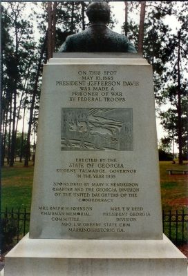
On East Main Street (U.S. 280) at North Broad Street (U.S. 129), on the right when traveling west on East Main Street.
Erected June 3, 1925 by Abbeville Daughters of the Confederacy to dedicate the spot where Jefferson Davis our great Confederate leader camped May the 9th 1865 the night before his capture. Love makes memory eternal. "Lest we forget." — — Map (db m164768) HM WM
On North Broad Street (U.S. 129) just north of West Main Street (U.S. 280), on the left when traveling north.
[south]”This carven stone is here to tell to all the world the love we bear to those who fought and bled and fell, whose battle cry was do and dare. Who feared no foe, but faced the fray — our gallant men who wore the . . . — — Map (db m164814) WM
On this site stood the old Georgia State Bank building in which Pres. Davis held the last official cabinet meeting of the Confederacy May 4, 1865.
Present
President Jefferson Davis •
Post. M. Gen. John H. Reagan •
Sec. of Navy Stephen R. . . . — — Map (db m66815) HM
On East Robert Toombs Avenue (Business U.S. 78) at Groves Street, on the right when traveling east on East Robert Toombs Avenue.
This museum shows the splendors of plantation life in Georgia before the War Between the States, displays relics, mementos and keepsakes of the era that tried men’s souls, and adds a fine collection of Indian relics for variety. Washington had . . . — — Map (db m26511) HM
On West Court Street at North Spring Street / West Square, on the left when traveling west on West Court Street.
Erected
Anno Domini 1908
By the
"Last Cabinet" Chapter
United
Daughters of The Confederacy,
Ladies
Memorial Association,
and
Sons of Veterans.
—
A tribute
of abiding love
for our
Confederate Heroes.
(Left . . . — — Map (db m30352) HM
On Georgia Route 112, 0 miles north of Pineview Street, on the right when traveling north.
To honor the memory of
Robert Toombs
July 2, 1810 – Dec. 15, 1885
United States Senator
Secretary of State, C.S.A.
Patriot and Statesman
For whom the town of Toombsboro is named — — Map (db m41908) HM
Near Walnut Street (Illinois Route 37) at Old U.S. 51, on the right when traveling north.
In memory of the Confederate Soldiers
who are buried at Mound City National Cemetery
May they never be forgotten
Erected by
United Daughters of the Confederacy
Seven Confederate Knights
Chapter 2625
Illinois Division,
Sons of . . . — — Map (db m161413) HM
On Park Street south of Harrison Street, on the left when traveling south.
Two blocks South of this marker
on March 6, 1814, was born
Sarah Knox Taylor
Daughter of
Capt. And Mrs. Zachary Taylor
Miss Taylor married Lieut. Jefferson Davis
at Louisville, Kentucky on June 17, 1835
and died in West Feliciana . . . — — Map (db m23263) HM
On Central Drive at Pear Drive, on the left when traveling north on Central Drive.
In loving remembrance of our
Confederate
dead
1861 -1865
[Plaque] This tablet was placed on this monument by the United States to mark the burial place of twenty-four Confederate soldiers who, while prisoners of war, died at . . . — — Map (db m226788) WM
On Main Street (Kentucky Route 94) at North 4th Street (Business U.S. 641), on the right when traveling east on Main Street.
[Front (north) side] Confederate Soldiers
[Left (west) side] Murray, KY May 1917
[Rear (south) side] Erected by J. N. Williams Chapter UDC
[Right (east) side] In Loving Remembrance — — Map (db m179598) WM
On South Main Street (U.S. 41) at Court Street, on the right when traveling south on South Main Street.
1861-1865
Erected by Christian County Chapter No. 590 United Daughters of the Confederacy
Soldiers from Christian County Kentucky
October 1911. — — Map (db m241836) WM
On North Main Street at East 4th Street, on the left when traveling north on North Main Street.
Here on Nov. 18-20, 1861, delegates from 68 counties of Kentucky in convention, by the ancient right of self determination and revolution, set up a newly constituted State of Kentucky. Henry C. Burnett, Trigg, was President of the Convention. . . . — — Map (db m124170) HM
On Old Main Street (Kentucky Route 2515) at North Court Street on Old Main Street.
Gen. Albert Sidney Johnston
Born February 2 - 1803
Washington, KY.
Killed at Shiloh Tenn.
April 6 - 1862
Graduated West Point 1826,
Black Hawk War,
War for Texas Independence,
Mexican War, . . . — — Map (db m84142) HM
On Jefferson Davis Highway near Pembroke-Fairview Road (Route 115), on the right when traveling east.
Zero Milestone
Jefferson Davis Highway
Fairview, Ky. - Biloxi, Miss.
Erected 1930 by
United Daughters of the Confederacy
Jefferson Davis
Born June 3, 1808
in Christian, now Todd Co. KY.
Died December 6, 1889
in New Orleans, . . . — — Map (db m3034) HM
Near East 10th Avenue at College Street, on the right when traveling east.
A newly constituted state of Kentucky, having been conceived in sovereignty convention Nov. 18-20, 1861 at Russellville,
established Bowling Green as its capitol. The commissioners to the Confederate Congress in Richmond were William Preston, . . . — — Map (db m129938) HM
Near Mississippi Street (State Highway 18) at Iberville Street, on the left when traveling north.
(center panel)
The Finest of Texas and Arizona,
Lives lost by river and bayou.
We mark their graves,
Remember their names:
Brave Confederates who died
At Fort Butler, June 28, 1863.
Martha M. Boltz
Virginia Division - . . . — — Map (db m86049) WM
On Louisiana Route 175 south of Parish Road 48, on the right when traveling north.
(Front)
General Alfred Mouton
1829-1864
(Back)
Prince C. J. de Polignac
Lt. Colonel July 1861
Col. 5th Tenn. Inft. Aug 1862
Brigadier General Feb 1863
Major General Apr 1864
Twice promoted for gallantry on the fields of Richmond, . . . — — Map (db m177857) HM WM
On Louisiana Route 175 south of Parish Road 48, on the right when traveling north.
To commemorate the victories of General Dick Taylor and his gallant soldiers at the Battles of Mansfield and Pleasant Hill, April 1864 — — Map (db m177856) HM WM
On Louisiana Route 175 south of Parish Road 48, on the right when traveling north.
In loving memory of the brave Confederate Soldiers who fought in this battle and to the courageous women who so nobly did their part. — — Map (db m177911) WM
On Louisiana Route 175 at Parish Road 1068, on the right when traveling north on State Route 175.
On this site, then the town of Pleasant Hill, on April 9th, 1864 Gen. Richard Taylor with 12,000 Confederates attacked the town, occupied behind log breastworks by Gen. Banks and 25,000 Federal troops. Through the afternoon the battle raged. That . . . — — Map (db m105402) HM
Near East First Street (State Highway 1) 0.1 miles south of Jones Lane, on the right when traveling south.
Side A
We care not whence they came
Dear is their lifeless clay
Whether unknown or known to fame
Their cause and country still the same
They died and wore Gray.
Side B
In memory of the thirty-nine members of Co. A. 2nd . . . — — Map (db m94473) HM WM
On Monroe Highway (U.S. 71/165) near Rainbow Drive, on the left when traveling east. Reported missing.
Fort Buhlow and Fort Randolph were earthwork/moat fortifications constructed beginning October 1864 by Confederate forces anticipating a repetition of Union Gen. Nathaniel Banks’ Summer 1864 Red River
Expedition. Construction, completed March 1865, . . . — — Map (db m7848) HM
On East Jefferson Highway (State Highway 44) at Ellis Street, on the right when traveling east on East Jefferson Highway.
Incorporated November, 1947, located partly on Indian-French settlement & trading post site. In 1739 much of this area was sold to Joseph Delille Dupart, a Commissioner of Indian Nations under Bienville. Today area is location of various industries. . . . — — Map (db m71147) HM
Near State Highway 18 at East 3rd Street, on the right when traveling east.
As Madame Beauregard lay dying in New Orleans, she yearned to see her husband once more, but his duties in the Confederate Army made his return impossible. She knew her husband could not be spared as a soldier of the South, and she resigned herself . . . — — Map (db m85143) HM
Near Camp Moore Road (State Highway 1052) east of U.S. 51, on the right when traveling north.
This cabin was believed to be built in 1929 to serve as the meeting house for the Camp Moore Chapter No. 562, United Daughters of the Confederacy and served in that capacity for many years. It originally stood east of Marker No. 2 but was removed to . . . — — Map (db m92336) HM
On Mount Royal Avenue. Reported permanently removed.
Gloria Victis-To the Soldiers and Sailors of Maryland in the service of the Confederate States of America. 1861-1865
{The front of the base of the monument} — — Map (db m62306) WM
On West Redwood Street, on the right when traveling east. Reported missing.
Within this cemetery is buried Brig. General Lewis A. Armistead Born New Bern, N.C. Feb. 16, 1817 Died at Gettysburg, Pa. July 3, 1863 Where men under his command made the farthest northern advance by any Southern troops Captain U.S. Army . . . — — Map (db m176185) HM
On Cockey’s Mill Road at Reisterstown Road (Route 140), on the right when traveling east on Cockey’s Mill Road.
Chief of the Confederate States Army Signal Corps and Secret Service Bureau, 1862–1865. Appointed Commissioner of Prisoner Exchange with rank of Colonel in April 1865. The Norris Home, “Bookland,” stood 2½ miles south of this . . . — — Map (db m2064) HM
Near Urbana Pike (Maryland Route 355), on the left when traveling south. Reported permanently removed.
Here on farmlands bordering the Monocacy River, the fate of the nation’s capital was decided July 9, 1864, when Union troops confronted Confederate soldiers marching toward Washington. Though the Confederates won this battle on Northern soil, they . . . — — Map (db m41915) HM
On Beallsville Road (Maryland Route 109) at Darnestown Road (Maryland Route 28), on the right when traveling south on Beallsville Road.
On September 9, 1862, the running engagement between Illinois, Indiana, and Virginia cavalry units that began the day before in Poolesville continued in Beallsville when two Federal regiments forced the single regiment of Virginia cavalrymen posted . . . — — Map (db m1681) HM
On Georgia Avenue (Maryland Route 97) 0.1 miles north of Damascus Road (Maryland Route 650), on the left when traveling north. Reported missing.
May 15, 1862, with seventeen young Marylanders he organized First Maryland cavalry. He served consistently and gallantly, rising from Private to Lt. Colonel. Killed at South Anna River, Virginia, June 1, 1864. — — Map (db m362) HM
Near Courthouse Square. Reported permanently removed.
To
Our Heroes
of
Montgomery Co.
Maryland
That We Through Life
May Not Forget to Love
The Thin Gray Line
Erected A.D. 1913
1861 CSA 1865 — — Map (db m106402) WM
On Charlotte Hall Road south of Charlotte Hall School Road, on the left when traveling south. Reported permanently removed.
(1807–1877) Born Charles County. Attended Charlotte Hall Mil. Academy. US Navy – Mexican War. Practiced Law. Commissioned in CSN 1861. Captained CSS Sumter. Later commanded CSS Alabama. Most successful raider with 82 naval victories. . . . — — Map (db m140069) HM
On Shepherdstown Pike (State Highway 34), on the right when traveling west.
C.S.A.
On this site in an oak grove from Sept. 15 to Sept. 18, 1862, stood the headquarters tent of General Robert E. Lee commanding the Confederate forces. Purchased, restored and marked by the West Virginia Division, United Daughters . . . — — Map (db m5640) HM
During the War Between the States, 1861-1865 more than a thousand Confederates were imprisoned here of whom thirteen died.
D.B. Cartwright CO H 32 N.C.
James J. Cooper CO. F 17 N.C.
Col. T.J. Davidson 25 Miss
A. Diggs citizen, VA
Aquila . . . — — Map (db m59205) HM
On State Street east of South Wall Street, on the left when traveling east.
”Lest we forget – lest we forget”
To the boys who wore the grey.
Erected by the Natchez Chapter No. 304
Daughters of the Confederacy
January 19, 1950
Commemorating those who left from
Natchez and Adams County
Mustered . . . — — Map (db m127098) WM
On South Court Street near North Pearman Avenue, on the right when traveling west.
Front (East)
To the memory
of our
Confederate Dead.
1861-65.
Dead upon the field of glory
Hero fit for song and story.
Rear (West)
Bolivar County's
tribute to
southern heroism.
No nation . . . — — Map (db m90270) WM
Near Park Lane Drive at South Church Street (Route 245).
Chickasaw County's tribute
to the sons who wore the gray
and were faithful to the cause.
Erected under auspices of
Okolona Chapter U.D.C. No. 117.
— — Map (db m102750) WM
On Elks Lake Road at Dixie Barn Road on Elks Lake Road.
Citizens of the Dixie community built this structure 1/4 mile southeast of this site in the 1930s to serve as a cafeteria during the Depression era. The log cabin has also served as a meeting place, music hall and classroom. In 2003 the cabin was . . . — — Map (db m56534) HM
On North Main Street at Eaton Street, on the right when traveling south on North Main Street.
[Northeast Inscription]:
C.S.A.
To the Men and Women of
the Confederacy
1861-1865
[Southwest Inscription]:
When their county called
they held back nothing.
They cheerfully gave their
property and their lives.
. . . — — Map (db m39867) HM