945 entries match your criteria. Entries 401 through 500 are listed.⊲ Previous 100 — Next 100 ⊳
Historically Black Colleges and Universities Historical Markers
This series collects markers describing historical events, persons, and buildings related to the 100+ Historically Black Colleges and Universities (HBCUs).
On Margaret W Alexander Drive east of Missouri Street, on the left when traveling east.
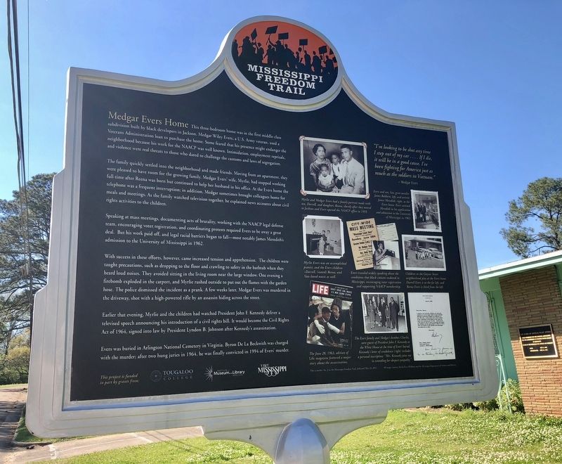
Medgar and Myrlie Evers moved into this
home with their children - Darrell and Reena -
in 1955 after Medgar became Mississippi's first
NAACP Field Secretary. Son Van was born in
1960. Evers was an outspoken activist for
voter . . . — — Map (db m115401) HM
On East Capitol Street east of North Farish Street, on the right when traveling west.
Woolworth's variety store was the scene of a pivotal event in the Mississippi Civil Rights Movement on May 28, 1963. When three black Tougaloo College students sat down at the white lunch counter seeking service, the nonviolent protesters were . . . — — Map (db m105565) HM
On High Street 0.1 miles east of North West Street, on the right when traveling east.
Front
On June 26, 1966, James Meredith's "March Against Fear" — led by Stokely Carmichael. Martin Luther King, Jr., Floyd McKissick, and others after Meredith was shot and wounded — ended its three-week trek from Memphis . . . — — Map (db m89745) HM
On John R. Lynch Street at Short Hickory Street, in the median on John R. Lynch Street.
Front
From this building, COFO (Council of Federated
Organizations) coordinated efforts of SNCC,
NAACP, CORE, SCLC, and other activist groups
from early 1963 through early 1965. Clarksdale's
Aaron Henry was COFO president. Bob . . . — — Map (db m115397) HM
Near Gibbs-Green Plaza 0.1 miles west of Dalton Street, on the right when traveling west.
Tragedy struck Jackson State College on May 15, 1970, when Jackson police and Mississippi Highway Patrol officers suppressed student unrest with intense gunfire. Phillip Lafayette Gibbs and James Earl Green were killed and many injured when bullets . . . — — Map (db m178451) HM
On John R. Lynch Street west of South Prentiss Street, on the right when traveling east.
Tragedy struck Jackson State College on May 15,
1970, when Jackson police and Mississippi
Highway Patrol officers suppressed student unrest
with intense gunfire. Phillip Lafayette Gibbs
and James Earl Green were killed and many
injured when . . . — — Map (db m109209) HM
Front
The courage of Tougaloo College students, faculty, and staff fueled the Jackson Civil Rights Movement. Inspired by the bravery and resolve of Medgar Evers, students and faculty attempted to integrate Jackson's main public library, . . . — — Map (db m115722) HM
On West Wiygul Street at South Gaither Street, on the left when traveling west on West Wiygul Street.
Front
Jazz bandleader and saxophonist James Melvin “Jimmie” Lunceford was born just outside Fulton on June 6, 1902. He formed his first band, the Chickasaw Syncopators, while teaching at Manassas High School in Memphis in 1927, and by . . . — — Map (db m96781) HM
On Main Street at Medgar Evers Boulevard, on the right when traveling north on Main Street.
In 1973 Mayor Charles Evers of Fayette and B. B. King began to cosponsor concerts at the Medgar Evers Homecoming in honor of the slain civil rights activist. Dozens of blues, soul, and gospel acts performed at the annual festival during . . . — — Map (db m162116) HM
On U.S. 61 at Rodney Road, on the right when traveling south on U.S. 61.
The town of Lorman was first settled in the early 1800s and known by a variety of names, including Lee, Lick, and Hays. In 1884, the town was formally platted when the Louisiana, New Orleans, and Texas Railroad purchased land from Mrs. Charlotte . . . — — Map (db m105737) HM
Near Galtney-Lott Plaza west of University Circle.
Front
On October 1, 1962, James Meredith broke the rigid segregation in Mississippi's higher education when he became the first African American student at the University of Mississippi. Though federal courts had ordered his admission, . . . — — Map (db m102580) HM
On 25th Avenue at 5th Street, on the left when traveling north on 25th Avenue.
Meridian blues and jazz performers have played important roles in musical history, both locally and nationally, not only supplying a foundation for other genres but also propelling music in new directions. Notables with Meridian roots include . . . — — Map (db m111037) HM
On North Liberty Street (U.S. 51) at West Peace Street (State Highway 22), on the left when traveling north on North Liberty Street.
CORE Activists David Dennis, Matheo Suarez, and George Raymond opened a Madison County office in 1963 to register black voters, the majority in white~controlled Canton. Co~directors Raymond and Suarez were joined by Annie Devine and C.O. Chinn . . . — — Map (db m105553) HM
On West County Line Road west of Tougaloo Boulevard, on the right when traveling west.
Founded in 1869 by the American Missionary
Association, which began as a New York-based
abolitionist society. Tougaloo University was
chartered as a teaching college in 1871 and
conferred its first baccalaureate degree in 1901.
The school was . . . — — Map (db m219755) HM
On West College Avenue 0.1 miles west of South Craft Street, on the left when traveling west.
At the original site of the Asbury Methodist Church, the Upper Mississippi conference was organized on February 5, 1891. Classes first held in the church led to the establishment of Rust College. — — Map (db m85132) HM
On Rust Avenue east of North Memphis Street (State Route 7), on the right when traveling east.
In 1964-65, the Council of Federated Organizations (COFO) came to Holly Springs, MS.
This monument is in honor and recognition of the students who came from across the country and joined with Rust College students and local citizens to register . . . — — Map (db m117499) HM
On East College Avenue at North Center Street, on the right when traveling west on East College Avenue.
(side 1)
Although Delta blues often claims the spotlight, other styles of the blues were produced in other regions of Mississippi. In the greater Holly Springs area, musicians developed a "hill county" blues style characterized by few chord . . . — — Map (db m84875) HM
On East College Street at South Market Street, on the right when traveling west on East College Street.
Born the eldest child to Elizabeth and James Wells, she grew up in Holly Springs, and attended Shaw University, now Rust College. She was a reformer who insisted on economic and political resistance to oppression. She became head of a household at . . . — — Map (db m136680) HM
On North Memphis Street (Mississippi Route 7) 0.2 miles north of Rust Avenue, on the right when traveling north.
Estab. 1866 as Shaw Univ. for the education of freed slaves by Miss. Methodists and the Freedman's Aid Society. Renamed 1890 to honor Richard Sutton Rust, Methodist clergymen, educator and abolitionist. — — Map (db m116157) HM
On Rust Avenue east of North Memphis Street (State Route 7), on the right when traveling east.
In 1960 Rust College students, under the leadership of President E. A. Smith, boycotted the segregated HollyTheater, a protest that in 1962 evolved into a Rust chapter of the NAACP. The chapter offices were installed by Medgar Evers, NAACP . . . — — Map (db m116163) HM
On U.S. 51 0.3 miles north of State Route 740, on the right when traveling north.
Front
One of the few female performers of country blues, Jessie Mae Hemphill (c. 1923 – 2006) was a multi-instrumentalist who performed in local fife and drum bands before gaining international recognition in the 1980s as a vocalist and . . . — — Map (db m102871) HM
Front
Country music singer and composer O. B. McClinton, born and raised here in Senatobia, found his first musical success as a songwriter for 1960s Memphis soul labels. When Stax-Volt founded the Enterprise imprint for release of his . . . — — Map (db m102890) HM
On Levee Street north of Clay Street, on the left when traveling north.
From the earliest settlers to Vicksburg, African Americans have made significant contributions to social, educational, religious, economic and political progress.
Vicksburg was home to Hiram Rhodes Revels, the first African American U. S. . . . — — Map (db m190865) HM
On 1st Street East at Monroe Street, on the right when traveling east on 1st Street East.
Site of first African Methodist Episcopal Church (1864), and first Negro Masonic Lodge in Mississippi organized here (1875). Campbell College was organized here in 1890. Present church was built in 1912. — — Map (db m103754) HM
On First East Street at Monroe Street, on the right when traveling east on First East Street.
Bethel AME Church
The Bethel African Methodist Episcopal (AME) Church was founded in 1864 when purchased from the First Presbyterian congregation. The original building, built in 1828, was replaced by the current Romanesque Revival . . . — — Map (db m115481) HM
On Monroe Street north of Jackson Street, on the right when traveling north.
Fannie Vick Willis Johnson
Fannie Johnson spent her life helping others and avoiding publicity. She funded two YMCAs during the days of racial segregation. The "Blacks Only" YMCA was located here with the "Whites Only" YMCA three blocks . . . — — Map (db m115473) HM
On East Broadway 0.1 miles west of North 1st Street, on the left when traveling west.
Gravesites for blacks were initially segregated in the south-central end of Columbia Cemetery near its intersection of Boone Road and Todd Drive. Blacks buried in this section include famed ragtime pianist and composer J.W. "Blind" Boone and . . . — — Map (db m169446) HM
On North Garth Avenue at East Ash Street, on the right when traveling north on North Garth Avenue.
Trubie's Market, 115 N. Garth, was owned by Trubie (Edwards) Smith from the early 1940s to the mid-1960s. it was one of few neighborhood markets serving blacks and one of the few women-owned businesses in the city then. "Ms. Trubie," who was . . . — — Map (db m169462) HM
On North Providence Road (State Highway 163) at East Ash Street, on the left when traveling north on North Providence Road.
Doby Flats—Stephen Doby, born on a S. Carolina plantation in 1854, came to Columbia about 1915. He built/owned Doby Flats (residential buildings) nearby and other houses. Wiggins Medical Clinic—Doby's daughter Ruth, a legendary teacher at . . . — — Map (db m169465) HM
George Washington Carver (1864-1943) was born in Diamond Grove, MO. As an agricultural chemist and inventor at Tuskegee Institute, now Tuskegee University, in Alabama, he developed a system of crop rotation. He also discovered 300 uses for . . . — — Map (db m261463) HM
On West Shrader Street west of Gallatin Street, on the right when traveling east.
James A. Gay
(1882-1985)
Professor (Prof.) James A. Gay, centenarian and principal of Garrison School for 22 years, was born in Fayette, Georgia, the son of Felix and China Gay. His grandfather was the son of a white plantation owner who . . . — — Map (db m274675) HM
On Chestnut Street 0.1 miles north of Dawson Drive, on the left when traveling north.
During the next four decades, Lincoln University surpassed all expectations, growing into a culturally rich and diverse institution. In 1954, when the United States Supreme Court made Brown v. the Board of Education the law of the land, Lincoln . . . — — Map (db m169380) HM
On West Main Street at Clay Street, on the right when traveling west on West Main Street.
The capital of Missouri, officially named the City of Jefferson in honor of the third U.S. President, is built on a site chosen by the First General Assembly, 1821, for a seat of government. St. Charles, until 1826, was the temporary capital . . . — — Map (db m263969) HM
On Chestnut Street 0.3 miles north of East Atchison, on the left when traveling north.
Lincoln University was founded by the black enlisted men of the 62nd and 65th United States Colored Infantries and their white officers who fought for the cause of the Union during the Civil War. The black soldiers of these two regiments . . . — — Map (db m169375) HM
On Chestnut Street north of Atchison Street, on the left when traveling north.
Dedicated to the
Officers and Soldiers
of the
62nd and 65th
United States
Colored Infantries
The construction of the
Soldiers' Memorial Plaza
was inspired by
the vision of
Dr. David B. Henson
17th President of . . . — — Map (db m62284) HM WM
On Chestnut Street just north of Dawson Drive, on the left when traveling north.
Lincoln University was founded by the black enlisted men of the 62nd and 65th United States Colored Infantries and their white officers who fought for the cause of the Union during the Civil War. the black soldiers of these two regiments were the . . . — — Map (db m169386) HM
On Chestnut Street 0.1 miles Dawson Drive, on the left when traveling north.
Towards the end of the war, the men began to solicit funds to accomplish this dream. With some donating as much as a year's salary to the cause, they were able to collect more than $6,000. Their efforts resulted in the establishment of a school that . . . — — Map (db m169376) HM
On Chestnut Street 0.1 miles north of Dawson Drive, on the left when traveling north.
With the deeding of its property to the state in 1879, Lincoln Institute formally became a state institution. Later, under the Second Morrill Act of 1890, the school became a land-grant institution. In 1921, the Missouri Legislature passed a bill . . . — — Map (db m169379) HM
On East McCarty Street 0.1 miles west of Locust Street, on the left when traveling west.
History
When Missouri became a state in 1821, the temporary seat of government was in St. Charles, Missouri. The Constitutional Convention was charged with the duty of selecting a permanent set of government and after much discussion and . . . — — Map (db m169360) HM
On Morgan Street near Main Street (U.S. 40), on the left when traveling east.
Born in slavery in St. Louis County, Mo.
Freed 1843
Founder, Elias Buckner African-American School in Boonville 1869 Established 32 Missouri schools for African-Americans in 1870
Secured state funding for Lincoln Institute (later Lincoln . . . — — Map (db m46016) HM
On Stan Musial Drive south of U.S. 60, on the right when traveling west.
Born in Carrabelle, FL in 1911 to
John Sr. and Luella O’Neil
Attended Edward Waters College
Married Ora Lee Owen in 1946
Played for the Kansas City Monarchs from 1938-1943
Managed for the Kansas City Monarchs from 1948-1955
Served . . . — — Map (db m72094) HM
On Main Street (Missouri Route 23) at SW 6th Street, on the right when traveling south on Main Street.
Side A: Massacre Site
On August 22, 1861, "State Guard" troops under Col. Edwin W. Price plundered this community taking household goods, farm animals and merchandise from Brockhoff's Store.
Sunday, Oct. 5, 1862, sixty drunken . . . — — Map (db m43980) HM
On Spring Street near Spring Hill Street, on the right when traveling west.
A former slave boy, George Washington Carver came to Neosho in the 1870s seeking an education. At Neosho’s Lincoln School, he began his long climb out of ignorance. This was his first step toward becoming a world-famous scientist and teacher at . . . — — Map (db m43025) HM
On Thompson Avenue at 4th Street, on the left when traveling south on Thompson Avenue.
1860...
Vision of Prosperity
Welcome to Sedalia, Pettis County seat and home of the Missouri State Fair. Sedalia, originally named Sedville, began as a vision in the mind and on the farm of George R. Smith. "Sed" was the nickname of . . . — — Map (db m85305) HM
On Main Street at Lamine Avenue, on the left when traveling east on Main Street.
A tribute to the living legacy of
Scott Joplin
and to Sedalia, "The Cradle of Ragtime"
Dedicated
June 1, 1999
——————————
[Wayside Interpretive Panel]
1st Page of the . . . — — Map (db m85294) HM
On Market Street 0.1 miles east of South Compton Avenue, on the right when traveling west.
A baseball park built for the Negro National League St. Louis Stars Stood on these Grounds
First professional baseball park in the United States of America owned exclusively by African Americans - built for the Negro National League St. Louis . . . — — Map (db m144044) HM
Father Dickson Cemetery was founded in 1903. The cemetery is named for Moses Dickson, a prominent African American abolitionist who passed away in 1901 and was re-interred here. This was one of the first public cemeteries in St. Louis available . . . — — Map (db m163583) HM
On Grant's Trail just west of Sappington Road, on the right when traveling west.
Sappington House
• The Sappington House is the historic home of Thomas Sappington. Thomas was one of the seventeen children of John and Jemima Sappington, early pioneers of the area. John and Jemima Sappington moved to this area in 1804 . . . — — Map (db m140976) HM
On Laclede Station Road at Thomas Street, on the right when traveling south on Laclede Station Road.
By the late 1800s, many local large landowners began subdividing their property for residential developments. Property formerly part of the Charles and Mary Rannells Home Farm was purchased by Evens Howard Firebrick Company along with adjacent . . . — — Map (db m145185) HM
On Atlantic Avenue just east of South Michigan Avenue, on the right when traveling east.
A native of Atlantic City graduated with honors as a pre-med student at Lincoln University in Chester County Pa. While completing his studies at Howard University School of Medicine in Washington D.C., Doggett was the recipient of several scholastic . . . — — Map (db m190927) HM
On Atlantic Avenue at North New Jersey Avenue on Atlantic Avenue.
Born in Catawba, S.C., this graduate of Johnson C. Smith University moved to Atlantic City and joined the Atlantic City Police Department in 1942. Enlisting in the United States Army during World War II, he served in the Pacific Theater of . . . — — Map (db m153444) HM
On Atlantic Avenue at No. Martin Luther King, Jr. Blvd, on the right when traveling west on Atlantic Avenue.
Born in Athens, Georgia, this educator, mayor, professional athlete and longtime Atlantic City resident was affectionately known as “Big Jim.” He was a 6' 6" giant of a man who never raised his voice. Jim was a classroom teacher and . . . — — Map (db m37066) HM
On Atlantic Avenue at North New York Avenue, on the right when traveling west on Atlantic Avenue.
Born in Greenville, SC, longtime Atlantic City resident, Maceo Turner was a prominent black attorney, war hero and civil rights leader. He earned his B.S. Degree from Virginia State College in 1939. He served with the U.S. Army from . . . — — Map (db m190929) HM
On Atlantic Avenue at Dr. Martin Luther King Boulevard, on the right when traveling north on Atlantic Avenue.
An Atlantic City native, 'Rennie' graduated from Atlantic City High School and earned degrees in business administration from Atlantic Community College and North Carolina Central University, respectively.
Upon returning to Atlantic City he . . . — — Map (db m114609) HM
On North Ohio Avenue just west of Gramercy Avenue, on the right when traveling west.
Born in Clinton, North Carolina, Wilbert Royal made Atlantic City his home after receiving his Master's Degree at North Carolina A&T University. Affectionately known as "Huff", he spent many summers in Atlantic City working as a bellhop at Lombardy . . . — — Map (db m190941) HM
On Shore Road (U.S. 9) at East Main Street, on the right when traveling north on Shore Road.
Last African-American Congressman of the Reconstruction Era.
Only black member of the 55th Congress.
Attorney and founding member of Whitesboro, NJ.
Recognizing that economic power would be the path to equality for Black Americans, . . . — — Map (db m168924) HM
Near East 143th Street east of Beekman Avenue, on the right when traveling west.
What was here before?
This site was once part of the estate of Jonas Bronck (1600-1643), for whom the Bronx is named. Later, the land was held by the family of Gouverneur Morris (1752-1816), an author of the U.S. Constitution. After 1857, . . . — — Map (db m275848) HM
On Salamanca Sugartown Road (County Route 98) 0.1 miles east of Cadiz Road (Route 69), on the left when traveling west.
The first settlers arrived here in 1806 and this area was called Conrad's Mills. Later the name was changed to Cadiz. Dairy farming was the main occupation in this tiny hamlet within the Township of Franklinville. The famous Ontario Knife Company . . . — — Map (db m86625) HM
On Adam Clayton Powell Jr. Boulevard at West 125th Street, on the right when traveling north on Adam Clayton Powell Jr. Boulevard.
1908 Born November 29, in New Haven, Connecticut.
1930 Received his BA from Colgate University, Hamilton, NY. Became assistant pastor at Harlem's Abyssinian Baptist Church.
1932 Received his MA in Religious Education from Columbia . . . — — Map (db m112429) HM
On Adam Clayton Powell Junior Boulevard at West 130th Street, on the right when traveling south on Adam Clayton Powell Junior Boulevard.
What was here before?
Originally settled by Dutch farmers in the late 1600s, the area was first named Nieuw Haarlem. After the American Revolution (1775-1781), the neighborhood's agrarian yield began to wane, resulting in the relocation of . . . — — Map (db m210011) HM
On East Water Street at East Genesee Street, on the right when traveling east on East Water Street.
”…when Susan B. Anthony urged Republicans to take a stand against slavery, Syracusans burned her in effigy in Hanover Square.”
Hanover Square (1) was a busy commercial district and civic gathering place in the mid-19th . . . — — Map (db m138796) HM
On Lawton Street south of Huguenot Street (U.S. 1), on the right when traveling south.
Frederick Douglas Patterson was born in Washington D.C. in 1901. Orphaned at the age of two, he was raised by his elder sister, a Texas schoolteacher. He was an educator, humanitarian and doctor of veterinary medicine. He is best remembered for . . . — — Map (db m270840) HM
On NC Highway 49, on the left when traveling north.
Charles Richard Drew
1904 - 1950
Black scientist and surgeon
Pioneer in the preservation of blood plasma
Medical director of the Blood-for-Britain Project, 1940
Director of the first American Red Cross Blood Bank, 1941 . . . — — Map (db m31142) HM
On Cabarrus Avenue W (State Highway 1002) east of Crowell Drive SW.
Presbyterian. Est. 1867 by Luke Dorland to educate Negro women, Scotia Seminary merged in 1930 with Barber Memorial Institute. Coed since 1954. — — Map (db m43383) HM
On Broad Street (U.S. 17) at George Street, on the right when traveling west on Broad Street.
Asst. Superintendent Public Instruction, 1868-70; a founder Livingstone College, 1885; Bishop A.M.E. Zion Church; founded St. Peters, 1864. One blk. N. — — Map (db m24053) HM
On Concord Street at Brant Street, on the left when traveling south on Concord Street.
Hillside High opened as a school for black students in 1921 at Pine and Umstead streets on land donated by John Sprint Hill. It moved in 1950 to a larger building, the former Whitted Junior High School, at this location. In 1996, Hillside High . . . — — Map (db m126192) HM
On University Drive at Hope Valley Road (North Carolina Highway 751), on the right when traveling east on University Drive.
Negro educational and religious leader. Founder of a college (1910), now N.C. Central University, its president to 1947. Grave 1½ miles S.E. — — Map (db m219796) HM
On Fayetteville Street south of Brant Street, on the right when traveling south.
The house was built in 1925 for Dr. James E. Shepard, founder and first president of North Carolina Central University, and his family, with funds collected until his death in 1947. The State of North Carolina purchased the home in 1949, and it . . . — — Map (db m126191) HM
On Fayetteville Street south of Eagle Campus Drive, on the left when traveling south.
In Loving Memory of
Beulah C. Bowens Fuller
1918-1997
Wilson, North Carolina
Class of 1940
North Carolina College for Negroes at Durham
A graduate of Darden High School in Wilson, North Carolina and the first in her family to . . . — — Map (db m126198) HM
On Fayetteville Street north of Formosa Avenue, on the right when traveling south.
Holy Cross Church, established in Durham in 1939 by the Maryland Province of the Society of Jesus, was among North Carolina's earliest African-American Catholic congregations. A rectory was built in 1942 with one room serving as the chapel, and this . . . — — Map (db m218218) HM
On Brant Street east of Fayetteville Street, in the median.
Administration and classroom centerpiece for New Georgian Style campus of North Carolina College for Negroes. Designed by the local architectural firm, Atwood & Nash.
North Carolina Central University Historic District — — Map (db m126200) HM
On East Grand Avenue (State Highway 43) near Holly Street, on the left when traveling south.
A founder in 1908 of Alpha Kappa Alpha,
nation’s oldest sorority for African Americans;
history teacher. Her grave is ¼ mile east. — — Map (db m48677) HM
On West St. James Street near Main Street (Business U.S. 64).
Editor of A.M.E. Zion Church papers; orator; a delegate to Methodist world conference; customs collector of Wilmington. Home stood 3 blks. E. — — Map (db m45347) HM
On East Granville Street near St. David Street, on the right when traveling east.
St. Paul A.M.E. Zion Church was organized
on the fourth Sunday in March 1866 under
the leadership of George C. Caine.
The house of worship was erected on the
corner of St. David and Granville Streets
in 1869.
We are grateful to . . . — — Map (db m46638) HM
On U.S. 301 at Bricks School Lane, on the right when traveling south on U.S. 301.
Established for blacks in 1895 through philanthropy of Mrs. Joseph K. Brick; became junior college in 1926. Closed, 1933. Buildings stood here. — — Map (db m221575) HM
On S. Martin Luther King Jr. Dr. at Cromartie St., on the right when traveling south on S. Martin Luther King Jr. Dr..
Founded Slater Academy, now Winston-Salem State Univ.; president, 1892-1904, 1913-34. Religious and community leader. Lived one block west. — — Map (db m52208) HM
On Wallace Street at Price Street, on the right when traveling east on Wallace Street.
Founder of Slater Academy
Now Winston-Salem State University;
President, 1892-1904; 1913-1934
Religious and Community Leader.
House Originally Located
Three Blocks West of Current Location — — Map (db m52739) HM
Near Burlington Road (U.S. 70) west of Palmer Farm Road, on the right when traveling east.
Palmer grounds keeper James Rudd Sr. constructed the altar with stones brought from across the country and the Caribbean. Each morning Brown prayed before beginning her long day at the school.
The altar was a favorite place for students and . . . — — Map (db m43127) HM
On South Elm Street at East February 1 Place, on the right when traveling north on South Elm Street.
Albion Winegar Tourgee, a native of Ohio and veteran of the Union Army, moved to Greensboro in 1865 and led a campaign to secure justice for African—Americans. He was an organizer of the Republican Party in NC, a delegate to the convention that . . . — — Map (db m219410) HM
On South Elm Street, on the right when traveling south.
Four Students at North Carolina A & T State University conducted the first lunch counter sit-in on February 1, 1960 at the Woolworth Store.
Franklin McCain
Joseph McNeil
Ezell Blair, Jr. David Richmond
"Sometimes taking a stand . . . — — Map (db m219413) HM
On US Highway 70 at Palmer Farm Road on US Highway 70. Reported permanently removed.
Palmer students always enjoyed baseball. Team photographs appeared in school bulletins as early as 1916. The field’s original orientation placed home plate and a wooden backstop at the corner of Palmer Farm Road and the highway.
In 1997, . . . — — Map (db m41753) HM
On Burlington Road (Route 70) west of Palmer Farm Road, on the right when traveling east.
Physical activity was an important part of life for Palmer students. In 1927, the same year Galen Stone Hall and Kimball Hall were completed, a clay tennis court was constructed between the buildings where the small parking lot behind you is . . . — — Map (db m292531) HM
Near Burlington Road (U.S. 70) west of Palmer Farm Road, on the left when traveling west.
From here you can get a sense of what Palmer Memorial Institute looked like during its height. Dr. Brown's vision for the campus was for it to resemble a New England college, reflecting her own early educational environment. She wanted her . . . — — Map (db m292515) HM
On Burlington Road (U.S. 70) west of Palmer Farm Road, on the right when traveling east.
Built in 1925, Canary Cottage served as Dr. Brown's residence until her death in 1961. From here, Dr. Brown had a fine view of the campus. Over the years, other residents of the home included Dr. Brown's three nieces, several female teachers, and . . . — — Map (db m292514) HM
Near Burlington Road (U.S. 70) 0.2 miles west of Palmer Farm Road, on the left when traveling west. Reported permanently removed.
Canary Cottage (c.1927-1928) was the personal residence of Dr. Charlotte Hawkins Brown, where she hosted numerous social functions for faculty, students, and her many friends.
Dr. Brown did keep canaries at her home. It is because of the . . . — — Map (db m43115) HM
Near US Highway 70 west of Palmer Farm Road. Reported permanently removed.
Eliot Hall, named in honor of noted educator Charles W. Eliot (1834-1926), was the school's main dormitory for boys. The structure was built in 1934 and is similar in style to Galen Stone Hall for girls on the opposite end of the Palmer campus. . . . — — Map (db m41751) HM
On US Highway 70 west of Palmer Farm Road, on the right when traveling east. Reported permanently removed.
The Charlotte Hawkins Brown Museum opened in 1987 to preserve and interpret the history and legacy of Dr. Charlotte Hawkins Brown, Palmer Memorial Institute, and African American education in North Carolina. It is located on the former campus of the . . . — — Map (db m41572) HM
Near Burlington Road (U.S. 70) west of Palmer Farm Road, on the right when traveling east. Reported permanently removed.
A remarkable example of achievement in the face of segregation and discrimination, Charlotte Hawkins Brown was buried on the grounds of the school she led for fifty years.
Charlotte Hawkins Brown was born in Vance County, North Carolina, the . . . — — Map (db m43305) HM
On Burlington Road (U.S. 70) west of Palmer Farm Road, on the right when traveling east. Reported permanently removed.
In 1846, Christian abolitionists established the American Missionary Association (AMA). After the Civil War, the AMA provided schools for African Americans in the South and founded Bethany Institute here in 1870. Few educational opportunities . . . — — Map (db m41744) HM
On East South Main Street (U.S. 158) at Kirkland Street, on the right when traveling east on East South Main Street.
Civil rights leader. She organized the Student Nonviolent Coordinating Committee, April 1960, at Shaw University. Her childhood home ¼ mi. E. — — Map (db m222004) HM
On West 5th Street just west of North Church Street, on the right when traveling west.
One trait of early Presbyterians in this region was their commitment to education, so that everyone could read the Bible. While many families in Mecklenburg County could not read and could not afford to educate their children, everyone who could . . . — — Map (db m175547) HM
945 entries matched your criteria. Entries 401 through 500 are listed above. ⊲ Previous 100 — Next 100 ⊳