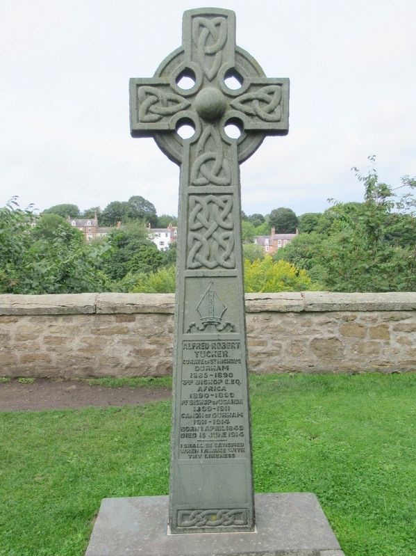
Alfred Robert
Tucker
Curate of St. Nicholas
Durham
1885 – 1899
3rd Bishop E.Eq.
Africa
1890 – 1899
1st Bishop of Uganda
1899 – 1911
Canon of Durham
1911 – 1914
Born 1 April 1849
Died 15 June 1914
I . . . — — Map (db m126288) HM
Capt Isidore Newman, MBE
Jewish Secret Agent WW2
Special Operations Executive (SOE)
lived at 52/53 Hawthorn Terrace.
He was betrayed in France
and murdered in Mauthausen
concentration camp in 1944
Be strong and of good courage, . . . — — Map (db m222723) HM WM
Charles William Vane Stewart
3rd Marquis of Londonderry
Earl Vane and Baron Stewart
Of Stewarts Court K.C. G.C.B.
Lord Lieutenant County of Durham
And Founder of Seaham Harbour
General in the Army
Born May 8th 1778 Died March 6th 1854 . . . — — Map (db m126168) HM
Durham Cathedral and Castle World Heritage Site
In Accord with the Principles of the World Heritage Convention Durham Cathedral and Castle have been designated a World Heritage Site
One of a number of protected areas of outstanding natural and . . . — — Map (db m122207) HM
George William Kitchin
Dean of Winchester
1883 1894
Dean of Durham
1894 1912
First Chancellor of
Durham University
Born Dec 7 · 1827
Died Oct 13 · 1912 — — Map (db m126289) HM
Remember in these cloisters which were finished in his day
John Washington
of Washington in this county, prior of this cathedral church 1416-1446, whose family has won an everlasting name in lands to him unknown. — — Map (db m253730) HM
Neptune
This statue was given to the City in 1729
by George Bowes M.P. of Gibside and Streatlam
as a symbol of the scheme to link Durham to the sea
by improved navigation of the River Wear.
It stood on top of the Market Place wellheads . . . — — Map (db m126170) HM
Old Registry
County Court House on this Site 1588 – 1811
Rebuilt as Diocesan Registry 1822
Passed to Union Society 1935
And to University Library 1978 — — Map (db m126290) HM
The Cloister has had lots of changes, repairs and conservation work over the years:
• 1000s: The first Cloister was built.
• 1093-1133: It was enlarged when the Norman Cathedral was built.
• Late 1100s: Bishop Hugh le Puiset remodelled the . . . — — Map (db m253728) HM
The Cloister, the area you are in now, is a series of four covered walkways set around a central grassed area, called the Cloister Garth. The first Cloister at Durham was built in the 11th century, and was later enlarged and extended. It provided a . . . — — Map (db m253727) HM
1758 1968
The Durham Light Infantry
Dedicated to All
Who Served in the Regiment
And in Memory of
Those Who Gave Their Lives
In the Cause of Freedom
Faithful
( side plaque )
The Regiment’s long connection with County . . . — — Map (db m126171) HM WM
To the Memory
Of the Men of
This Parish Who
Gave Their Lives
In the Great War
1914 – 1918.
Thomas Hindson Biggins Pte Som. L.I. · Rowland Burdon Capt. & Flt. Comdr R.F.C. · Thomas Burns L/Cpl Durham L.I. · James Henry Francis . . . — — Map (db m125904) WM
British Coal Corporation
Horden Colliery
Shaft Ref. North
Shaft Diameter 6090 mm
Shaft Depth 438 M
Depth to top of cap from top of monument 2 M
Date of Capping Aug. 94 — — Map (db m125912) HM
“For Home and Country”
Erected to the Memory of the
Men from this Parish who
Served in the Great War
1914 – 1918.
Those Who Fell
Richard Bell Adamson. · Robert Hodgson Adamson. · John Christopher Baty. · John Edward . . . — — Map (db m126343) WM
Eleven ‘O’ One
Known locally as ‘Tommy’
was bought on Aug 4th 2014
from the public local schools
businesses and Durham County
Council. He sits here
for future generations to
visit, enjoy and remember.
By — Ray Lonsdale
Two . . . — — Map (db m125911) WM
Remember
With Thanksgiving
The True and Faithful Men
Who In The Great War
Went Forth From This Parish
For God and the Right
The Names of Those
Who Returned Not Again
Are Here Inscribed
To Be Honoured For Evermore
1915 — . . . — — Map (db m126340) WM
25pr Mk II Saluting Gun
Calibre 87.6mm (3.45 inch)
Range 12km (13,400 yards)
Rate of Fire 6-8 rounds per minute
Shell weight 11.3kg (25lb)
This 25 pounder is used today by The Heugh Gun Battery to fire blank charges as a . . . — — Map (db m125799) HM
25pr Mk II Saluting Gun. 1942
Calibre 87.6mm (3.45 inch)
Range 12km (13,400 yards)
Rate of Fire 6-8 rounds per minute
Shell weight 11.3kg (25lb)
The 25 pounder is considered to have been one of the finest field artillery pieces . . . — — Map (db m125797) HM
5.5 inch Gun Howitzer
Calibre 140mm (5.5 inch)
Range 14km (15,300 yards)
Rate of Fire 3 rounds per minute
Shell weight 36kg (80lb)
The 5.5 inch Howitzer came into service in 1942 in the Western Desert of North Africa against . . . — — Map (db m125800) HM
Original 6 inch Mk 24
Calibre 152mm (6 inch)
Range 23km (25,400 yards)
Rate of Fire 6 to 8 rounds per minute
Shell weight 50kg (112lb)
A 6 inch Mk 24 was mounted here and, with its powered turret, would have been about a . . . — — Map (db m125758) HM
Original 6 inch Mk VII
Calibre 152mm (6 inch)
Range 14km (15,700 yards)
Rate of Fire 5 to 7 rounds per minute
Shell weight 45kg (100lb)
The original gun emplaced here was a Vickers 6 inch Mk VII gun, the workhorse of 20th . . . — — Map (db m125746) HM
A Trophy From Sebastopol
This Cannon Was Captured From the Russian Army
At the Battle of Sebastopol
During the Crimean War (1854-56). In October, 1857
The then Secretary of State, Lord Panmure,
Offered the Cannon to Hartlepool Borough . . . — — Map (db m125833) HM
Bofors L/60 40mm Anti Aircraft Gun
Calibre 40mm (1.57 inch)
Anti Aircraft Ceiling 7.9km (26,000 feet)
Rate of Fire 120 rounds per minute
Shell weight 0.7kg (2lb) High Explosive
The Bofors was a British version of a Swedish . . . — — Map (db m125761) HM
At 7pm on 14th December 1914 Winston Churchill, First Lord of the Admiralty, was told that "a battle cruiser attack on the East Coast was probably imminent", although what the precise objectives were it was impossible to say.
The SMS Seydlitz, . . . — — Map (db m125831) HM
It was thought that a buoy which the German fleet used as a guide had been moved further inland and the nearness of the German ships to the coast was the salvation of the batteries. A longer range would have given a trajectory bringing a dropping . . . — — Map (db m125832) HM
Burney 3.7 inch Mk I Recoilless Rifle
Calibre 94mm (3.7 inch)
Range approx 1km (1090 yards)
Rate of Fire Unknown
Shell weight Unknown
The requirement for light, highly mobile anti tank weapons led to experiments with . . . — — Map (db m125767) HM
The ancient tidal harbour of Hartlepool had become silted up by 1800 but was the obvious port from which to ship the coal of the South Durham collieries. From 1832 the dock was scoured by using sluices to release water from the Slake at low tide. . . . — — Map (db m125901) HM
This Tablet Marks the Place
Where the First Shell from the
Leading German Battle Cruiser
Struck at 8:10 A.M. on the
16th of December 1914
And Also Records the Place Where
(During the Bombardment)
The First Soldier Was Killed
On . . . — — Map (db m125803) HM WM
Welcome to the
Headland
Ancient Borough
of Hartlepool
This Gateway Marker was erected
2001 AD to celebrate the 800th
Anniversary of the grant of a Charter by
King John to the citizens of Herterpool,
The historic Borough of . . . — — Map (db m125835) HM
L6 Wombat 120mm Recoilless Rifle
Calibre 120mm (4.7 inch)
Range 1.1km (1,200 yards)
Rate of Fire 4 rounds per minute
Shell weight 12.8 kg (28lb)
The WOMBAT (Weapon Of Magnesium, Battalion Anti Tank Gun) was Britain's light . . . — — Map (db m125801) HM
3.7 inch Static Mount Anti Aircraft Gun
The Malta Gun
Between 1940 and 1943 the island of Malta, "Britain's unsinkable aircraft carrier" suffered almost continuous siege in the most sustained bombing campaign of World War Two. Germany . . . — — Map (db m125760) HM
3.7 inch Mk I Anti Aircraft Gun
Calibre 93.9mm (3.7 inch)
Anti Aircraft Ceiling 9.7 km (31,000 feet)
Rate of Fire 10 rounds per minute
Shell weight 12.7kg (28lb)
The Vickers anti-aircraft gun was introduced to the British . . . — — Map (db m125765) HM
4.5 Inch Mk III Naval & Anti Aircraft Gun
4.5 Inch Mk III
Calibre 114mm (4.5 inch)
Range 18.2 km (19,990 yards)
Anti Aircraft Ceiling 9.1km (29,900 feet)
Rate of Fire 14 rounds per minute
Shell weight 25 kg (55lb)
The . . . — — Map (db m125757) HM
4.7 inch Naval / Coast Defence Gun
Calibre 120mm (4.7 inch)
Range 9km (9,900 yards)
Rate of Fire 5 to 6 rounds per minute
Shell weight 20.4 kg (45lb)
The 4.7 inch gun was the first 'modern' breech loader and was accepted into . . . — — Map (db m125766) HM
Naval Gun 4 inch QF Mk 4 on Mk XVI Mount 1945
Calibre 100mm (4 inch)
Range 16,300 yards
Rate of Fire 10 - 15 rounds per minute
Shell weight 31lb, 14kg
The Naval Gun 4 inch QF first appeared in 1895 with the Mark IV being . . . — — Map (db m125759) HM
Naval Gun Barrel 4.5 inch QF Mk III
Calibre 114mm (4.5 inch)
Range 18.2 km (19,990 yards)
Anti Aircraft Ceiling 9.1km (29,900 feet)
Rate of Fire 14 rounds per minute
Shell weight 25 kg (55lb)
In the 1930s a Naval gun was . . . — — Map (db m125745) HM WM
The PS Wingfield Castle is a unique survivor of a type of passenger vessel which once was common across Britain. She is a symbol of the technical skill of local people, both during her construction on this very spot during the great depression of . . . — — Map (db m125686) HM
PSS Wingfield Castle
PSS Wingfield Castle is the largest exhibit at the Museum of Hartlepool. She was built here in Hartlepool by William Gray & Co and launched in 1934. She served as a passenger ferry on the River Humber with her sister ships PSS . . . — — Map (db m125689) HM
There would be approximately 12 miles of rope on board an average frigate of the Napoleonic era.
The Standing Rigging supports the masts. It is very thick as it has to bear a great deal of weight. These ropes could be as large as 10cm . . . — — Map (db m125685) HM
In Memory Of All Those
Who Lost Their Lives At Sea
( eleven granite tablets, set into the pavement, list the names of lost sailors ) — — Map (db m125687) HM
The Shipwrecked
Fishermen & Mariners
Royal Benevolent Society
16 Wilfred Street London S.W.I.
Founded 1833 For The Alleviation Of
Every Phase Of Shipwreck Distress
Among The Seafaring Population
And Their Dependents
Over 1,000,000 . . . — — Map (db m125690) HM
The Bombardment
of the Hartlepools
This memorial commemorates all those
across the Hartlepools who were killed or wounded
due to the naval bombardment of the 16th December 1914.
At least 114 civilians, 9 soldiers and 7 sailors were . . . — — Map (db m125834) HM WM
Throston Engine House was built 1838-1840 to accommodate a steam winding engine which hauled the coal wagons of the Stockton and Hartlepool Railway up 14 feet (4.3 metres) to the staiths of the Hartlepool Railway, at 3d (old pence) per ton of . . . — — Map (db m125902) HM
Castle Quarters
Alnwick Quarters
Aln, Celtic for bright river, and wick, an Anglo-Saxon settlement, point towards the possible origins of Alnwick. From the Normans to the Tudors, Alnwick, with its mighty castle, offered a strategic defence . . . — — Map (db m125983) HM
This Column of Remembrance
Is Dedicated to the Men of
Alnwick Who Gave Their Lives
In The Wars Of
1914 — 1918 & 1939 — 1945
We will remember them
( upper small plaque )
Korea War 1950 – 53
Flis. A. . . . — — Map (db m126057) WM
Fusiliers Museum of Northumberland
Bosnian Croat Army 76mm Artillery Gun
Regimental Sergeant Major Mac Leyland and Corporal Mac McGuiness, 1st Battalion Royal Regiment of Fusiliers took possession of this gun when on peace-keeping duties in . . . — — Map (db m126054) HM
Restored 1986
Presented by
Adam Robertson to
His Native Town
1890
Opened by Earl Percy June 8th 1891
Robertson’s Pant
This fountain
or pant was erected
in 1890 by Adam Robertson
local freeman and
benefactor as a
gift to his . . . — — Map (db m126056) HM
Sir Henry Percy 'Harry Hotspur' c1364 – 1403
“...and by his light did all the chivalry of England move to do brave acts.”
William Shakespeare - Henry IV, Part II
This statue was commissioned by Alnwick Community Development . . . — — Map (db m126055) HM
Sir Henry Percy Hotspur
Harry Hotspur was born at Alnwick Castle in 1364 or 1366 and was knighted in 1377 at the time when his father was created 1st Earl of Northumberland. He was supremely powerful in combat on land and sea, though sometimes his . . . — — Map (db m125984) HM
Early 19th Century Iron Mortar
Fitted to a wooden gun carriage this mortar is fitted with a cascabel. This ring at the breech or back of the cannon was used to attach lifting tackle when mounting or un-mounting it from its carriage. The mortar's . . . — — Map (db m125930) HM
It is believed that the castle acquired these two 24 pounder cannons when Napoleon was threatening to invade England in 1798. The stylised 'N' located on the left hand side of the breech is a naval service mark. This tells us that the cannons were . . . — — Map (db m125934) HM
This gun was purchased for £34.1.0. with an additional 74 barrels of gunpowder & a carriage bringing the total cost to £36.14.0. On 29th March 1784 Mr Cookson arranged to transport the 32 Pounder Gun on his sloop bound for Wareham, just outside . . . — — Map (db m125936) HM
This bell was originally in a cap house on top of the clock tower known also as the Belle Tower! As an integral part of the mechanism it sounded out at regular intervals. It was moved to its current site here in the apse of the chapel as its . . . — — Map (db m125982) HM
Bamburgh Castle Coastguard Station
In 1771 The Crewe Trustees published an:
“Account of the Signals made use of at Bamburgh Castle in the County of Northumberland in case Ships or Vessels are perceived in Distress, and of the charitable . . . — — Map (db m125937) HM
547 Bamburgh’s Recorded History Begins
Noted in the Anglo-Saxon chronicles, Ida the flamebearer conquers Din Guayrdi, Bamburgh, making it the capital of his kingdom of Bernicia.
607 – 634 Aethelfrith the Ravening Wolf
Added . . . — — Map (db m125927) HM
Once home to the Kings of Northumbria, from King Ida in the mid 6 Century, through toLord Armstrong, a ‘King’ of Industry, Bamburgh Castle has dominated this coastline from wooden palisade to sandstone fortress.
The story of Bamburgh goes . . . — — Map (db m125923) HM
This vaulted room is the middle floor of three built into the easterly of two towers on the inner curtain wall. The tops of the towers were removed during re-modelling in the late 1800s and now form seating areas The lower room is identifiable . . . — — Map (db m125978) HM
Originally discovered in the 19th century and thought to be a piece of a standing cross this piece of stone was later identified as belonging to a stone chair. It is currently on display in the Archaeology Room. It has been dated to around 800AD . . . — — Map (db m125941) HM
History
Often confused with the pillory, stocks were only designed to hold the legs and occasionally arms, whereas the pillory held the head as well. Perhaps the most famous person placed in the stocks was Cardinal Wolsey after he got drunk at . . . — — Map (db m125939) HM
Dating from the late 1600s this cannon was affectionately named the Armada Gun as it was believed to have come from a Spanish Armada vessel after the fleet was driven up the North Sea Coast. It was later confirmed as a Dutch trading vessel that . . . — — Map (db m125977) HM
The islands before you are the Farne Islands between 15 and over 20 depending on the state of the tide.
The islands were a renowned hazard to shipping and in the 18th Century, Dr Sharp, working for the Trustees of Lord Crewe, created one of . . . — — Map (db m125925) HM
Hadrian's Wall formed the north-west frontier of the Roman empire for most of the period AD 122-410. The empire's frontiers extended over 5,000 km from the Atlantic coast of Britain through Europe, the Middle East and across North Africa to the . . . — — Map (db m85985) HM
Where National Park meets World Heritage Site
Your visit
You have come to a very special place. The landscape is full of clues to our past, but it is also important for our future.
Not just a pretty place
The inspirational landscape . . . — — Map (db m86361) HM
Corbridge
The scene of stormy events in the past.
In 796 Ethelred, King of Northumbria was slain here.
In 918 King Regnald the Dane defeated the English and Scots armies here.
In 1138 King David I of Scotland occupied the town.
In 1201 it . . . — — Map (db m125635) HM
Corbridge Roman Site
The first Roman fort at Corbridge was built about a kilometre to the west of here. It was built as a supply base for the Roman advance into Scotland in about AD 80. Five years after the fort was abandoned, the first of a series . . . — — Map (db m125529) HM
To the Greater Glory of God
And in Never Fading Memory of All
Who the Noble Sons of This Parish
Who Laid Down Their Lives
For God King and Country in the
Great War 1914 – 1918
This Lychgate was Erected 1920
“A People That . . . — — Map (db m125634) WM
The Courtyard Building
About AD 165 a new layout for Corbridge was planned. The earlier fort buildings were mostly demolished and a little later work began on this large courtyard building. We do not know with certainty the original function of the . . . — — Map (db m125540) HM
The Early Forts
The earliest forts at Corbridge were built largely of timber. It was not until the middle of the second Century, when the last fort was built, that extensive use was made of stone.
The remains which you can see here belong to . . . — — Map (db m125541) HM
The East Military Compound
You are now standing in the east military compound, some of which lies buried in the field behind you. The most substantial remains within the compound belong to a pair of residential houses to your left, in the . . . — — Map (db m125542) HM
The Fountain House
An aqueduct brought water into the site from the north to feed a fountain here. The water flowed through an ornamental fountain-head into a large basin surrounded with decorated stone screens and from there into the stone trough . . . — — Map (db m125539) HM
The Golden Lion was built from stones from Dilston Hall, demolished in 1768 during the break up and sale of the property after Lord Derwent-Waters execution for his part in the Jacobite Rebellion. The stone originally came from the Roman bath . . . — — Map (db m125631) HM
The Granaries
In front of you are the remains of two large granaries. They were designed to store grain to make bread, an important part of a Roman soldier's diet.
Inside the buildings the stone floors rest on low stone walls with channels . . . — — Map (db m125538) HM
The Main Street
This was the main street of the town. It formed part of an important Roman road known as the Stanegate which ran all the way from Corbridge to Carlisle. To your left are the remains of shops, a fountain, and two granaries. On its . . . — — Map (db m125531) HM
The Old Market Cross
Which, mounted on a Roman altar from Corstopitum, stood for some 6oo years in the market place it was removed in 1807, and restored and re-erected on its present site in 1975. — — Map (db m125639) HM
The Side Street
This is the side street which divides the two military compounds. Originally it joined the Stanegate (the main street), but sometime in the third or fourth centuries a wall was built which closed off the far end and also linked the . . . — — Map (db m125543) HM
The West Headquarters Building
This building is thought to have been the administrative headquarters of the west compound. It was divided internally into six rooms probably with arched openings between them. The room in the centre at the back of . . . — — Map (db m125546) HM
The West Military Compound
You are now standing in the west military compound some of which lies buried in the field behind you. To your left. opposite the main gate, is the Headquarters building. There is a small underground chamber which is . . . — — Map (db m125544) HM
Vicar’s Pele
This tower, the finest of its kind, was built about AD 1300 for a Vicar of Corbridge and was lived in as a fortified vicarage until the early seventeenth century. — — Map (db m125637) HM
16th Century Bastle House Ruined buildings were adapted and new ones built at Housesteads in the centuries after the Romans left, when the land around became an upland farm. In the 16th century a local family built a fortified house onto the . . . — — Map (db m126423) HM
A Changing Fort
During its 280-year life, many changes were made in the fort, no more so than to building XV. Over the years, it served as a workshop, a barracks, a stable, and a storehouse before a small bathhouse (balneae) was placed . . . — — Map (db m126449) HM
A military community Villages like Vindolanda were a vital part of the military occupation of Hadrian's Wall, and were planned extensions of the forts themselves. They provided extra space for facilities such as shops, workshops, additional . . . — — Map (db m126419) HM
To the Glory of God
And in Proud and Loving Memory
Of the Men of This Parish, Who
Gave Their Lives in the Great War
1914 — 1918
William Frederick Pearson.
Gilbert Graham.
William Vickers.
George Sparke.
“Greater love . . . — — Map (db m126414) WM
Barracks: the Last Hundred Years at Housesteads
Archaeology has revealed radical changes to the fort beginning around AD 300. One of the most important was the reconstruction of the barracks from single long buildings into smaller individual . . . — — Map (db m126447) HM
The remains of the stone buildings that you see around you are but a fraction of what was once here at Vindolanda in ancient times. Before the last stone fort was built around AD213, eight forts had preceded it. Most of the earlier forts were . . . — — Map (db m126354) HM
195 entries matched your criteria. The first 100 are listed above. The final 95 ⊳