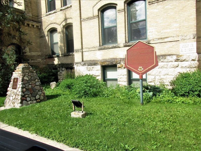
Higher Education in Western Manitoba traces its beginnings to Rapid city where in 1880 the Baptist community established Prairie College. In 1884 it was succeeded by the McKee Academy which moved to Brandon in 1890.
Brandon College was . . . — — Map (db m204698) HM
Brandon Courthouse and Gaol
Brandon's importance as a major centre in southwestern
Manitoba was confirmed when it was selected in 1883 as
the headquarters for the newly created Western Judicial
District of Manitoba. The Brandon . . . — — Map (db m289837) HM
The Burchill & Howey Block was constructed in 1906 and designed by notable Brandon architect, W.A. Elliott. The main floor of the structure was originally used by its owners as a retail butcher shop until 1945 when the property was sold to the . . . — — Map (db m290251) HM
Designed by W. A. Elliot, one of Brandon’s most prominent architects, the Central Fire Station was built in 1911 and stands on the site of its 1882-1893 predecessor. Elliot’s youngest son, Egbert, proposed the addition of the Station’s Tower. The . . . — — Map (db m204876) HM
Brandon's first mayor, Thomas Mayne Daly, hired local architect firm McCoskie & Co. to design this house for him in 1882 during Brandon's first decade of settlement. Daly was also appointed as Canada's first Juvenile Court Judge in 1909. This . . . — — Map (db m204875) HM
[English] Former Merchants Bank Building The Merchants Bank opened its first Brandon office in 1882, shortly after the townsite was chosen. This building, designed by the Montreal architectural firm of Taylor, . . . — — Map (db m290283) HM
This house was built for George A. Paterson in 1893 by
Brandon's William Bell and Sons. 1039 Louise Avenue is a
splendid example of the Eastlake style of architecture, which
is characterized by an abundance of ornamentation produced by
the . . . — — Map (db m289840) HM
This cairn is faced with stone from the walls of Prairie College, the forerunner to Brandon College and Brandon University. It was constructed in 1999, Brandon University's Centennial Year. Prairie College was the first post-secondary educational . . . — — Map (db m204700) HM
[English] Born near London, Upper Canada, Sifton as lawyer, politician, businessman and principal owner of the influential Manitoba Free Press, had great impact on Canadian development. As a member of the Manitoba Cabinet, he . . . — — Map (db m200468) HM
In 1881 Thomas Mayne Daly arrived in Manitoba from his native town of Stradford, Ontario and began his distinguished legal and political career in Brandon.
Elected the first Mayor of Brandon in 1882, Daly actively promoted civic development in . . . — — Map (db m204701) HM
The open landscape close to the CPR main line made this site attractive for summer training camps for artillery, infantry, and cavalry units. Established as Sewell Camp in 1909, it was renamed in honour of Major-General Sir Sam Hughes, . . . — — Map (db m218701) HM
Established in 1909, Camp Sewell (renamed Camp Hughes in August 1915) opened on a war-time footing in 1915. Compared to the summer of 1914 when almost 7,000 militia soldiers trained, camp strength more than doubled to 15,000 soldiers. A . . . — — Map (db m218681) HM
[English] Named after Sir Sam Hughes, Minister of Militia and Defence (1911–1916), this site contains the most intact First World War battlefield terrain created for training purposes in Canada. One of a dwindling number worldwide, . . . — — Map (db m218700) HM
[English] Camp Hughes, originally named Camp Sewell, was established in 1909 as the Central Training Camp for Military District 10 (Manitoba, Saskatchewan, North-West Territory and N.W. Ontario). The terrain was selected for its . . . — — Map (db m218702) HM
[English] Sewell Station was located on the Canadian Pacific Railway line. In 1881, the CPR had reached a point between Carberry and Douglas approximately seven miles east of Douglas. The Railway laid sidings at Sewell (later known . . . — — Map (db m218698) HM
[English]
During the Great War, Camp Hughes became the 2nd Largest “city” in Manitoba, second only to Winnipeg. By 1916, the camp was divided into five brigade areas: Central; South Central; West; North-East and South-East Camps. . . . — — Map (db m218708) HM
[English] The area immediately south of the main rail line and sidings was established as a headquarters and administrative support area. It contained several wood frame structures including the Commandant's Hut (and Staff Lines), . . . — — Map (db m218699) HM
[English] The Canadian Army Medical Corps, Military District 10, established at Camp Hughes in 1915, a Field Ambulance Depot to raise volunteers for overseas service. As well, a hospital at the Camp was set up consisting of 250 . . . — — Map (db m218704) HM
[English]
To the north-west of the Canadian Pacific Railway station lies a large, flat expanse of land. It was here that parades of the camp garrison, comprising up to 30,000 troops took place. Revues of note occurred in 1915 . . . — — Map (db m218697) HM
[English] When not training soldiers had many opportunities and venues within the Camp to keep themselves occupied. The YMCA and the Knights of Columbus maintained large marquee tents where the men could read books and newspapers, . . . — — Map (db m218684) HM
[English] During the Great War, training at Camp Hughes emphasised basic infantry soldiering where the new recruit learned drill, weapons handling, manoeuvre and tactics. In addition certain specialties were instructed. Signalers . . . — — Map (db m218707) HM
[English] The Camp Hughes trench system was developed in 1915/1916 to teach recruit soldiers the lessons of trench warfare which had been learned through great sacrifice on the battlefields of France and Flanders. Seasoned veterans . . . — — Map (db m218705) HM
[English] An internationally renowned writer, artist, and social reformer, Seton was passionately interested in nature and the relationship of Native peoples to their environment. His realistic animal stories were best-sellers that . . . — — Map (db m201689) HM
[English] Designed under the direction of Thomas Fuller, chief architect for the Department of Public Works from 1881 to 1896, this structure was built in 1895-1898. The federal presence was extended across Canada by public . . . — — Map (db m200606) HM
In the early years fire was an ever-present danger both in town and on the farms. The old newspapers are full of accounts of fires started from lamps and heated stovepipes. These fires were very difficult to control because of lack of available . . . — — Map (db m200584) HM
Erected by the Citizens of Elkhorn and district in memory of those who fell in the great war
1914 - 1918
They Gave Their All
1938 - 1945
Brennand G. •
Duxbury T. •
Duke A.S. •
Jenner J. •
McDonald J. •
Mallett R. • . . . — — Map (db m204710) WM
[English] When A.C. (Ace) Emmett arrived in 1902, Manitoba had only a few passable roads. Railways provided the chief means of mass transportation. Most automobile owners were concentrated in Winnipeg. Emmett energetically led the . . . — — Map (db m200618) HM