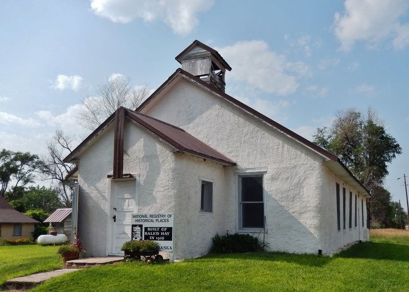
The invention of mechanical balers in the mid-1800s led to the use of bales of hay or straw as building blocks. Pioneer builders developed structural bale walls using cuttings of either native prairie flora — baled-hay — or of agricultural waste, . . . — — Map (db m223422) HM
Ainsworth Army Air Field, completed on November 30, 1942, was a satellite of Rapid City Army Air Field and under command of the Second Air Force. The field was one of eleven Army Air Force training bases built in Nebraska during World War II. The . . . — — Map (db m77760) HM
Lakeland High School was constructed 20 miles south of this site by ranchers from several rural school districts during the summer of 1934. School began that September with 11 students. Constructed of prairie sod, with a sod roof supported by pole . . . — — Map (db m9623) HM
Like many Nebraska communities, Long Pine's history is tied to railroad development. When the Fremont, Elkhorn, and Missouri Valley line arrived in 1881, Long Pine became a bustling railroad town. The Chicago & North Western Railroad (CNW) built a . . . — — Map (db m182061) HM
The first ranch in this area was set up on the Niobrara River about five miles south of here in 1877. E. S. Newman established his ranch to sell cattle to the government for delivery to the Indians at the Pine Ridge Agency to the north.
The . . . — — Map (db m9622) HM
This natural valley extending east and west across the Sandhills became known as Survey Valley after the Burlington and Missouri River Railroad surveyed a prospective line from O’Neill to Alliance in 1887. No rails were ever laid. On January 19, . . . — — Map (db m178711) HM
This arched cantilever truss bridge, connected in the center with a single pin, is the only one of its kind in the United States. It was built in 1932 by the Department of Public Works and named by the local citizenry in honor of Governor Charles . . . — — Map (db m70625) HM
When a Sioux Indian reservation was established north of here in Dakota Territory in 1878, early settlers in the region grew fearful of attack. They requested military protection, and in 1880 Fort Niobrara was built a few miles east of present-day . . . — — Map (db m77753) HM
At 10:45 a.m. on February 5, 1944, 1st Lt. John B. Beatty of Sandusky, OH, and 2d Lt. Earnest W. Fanslau of Mantua, NJ took to the air from the Ainsworth Army Air Field in two P-47 "Thunderbolt" fighter planes for an instrument training flight. Lt. . . . — — Map (db m77754) HM
Nebraska Sand Hills has been designated a National Natural Landmark This site possesses exceptional value as an illustration of the Nation's natural heritage and contributes to a better understanding of Man’s environment 1984 National . . . — — Map (db m178499) HM
The Grand Island and Wyoming Central branch of the Burlington railroad came through this area in 1887 and built a siding here named Mullen after a railroad contractor. In 1888 Trefren and Gandy platted the village of Mullen. Hooker County, named . . . — — Map (db m178920) HM
When the Burlington & Missouri River Railroad (now the Burlington Northern-Santa Fe) reached this point in 1887, it built a siding named Hecla after a volcano in Iceland. A post office was established the same year, and construction of stockyards . . . — — Map (db m180869) HM
Before you is a settlement success story resulting from the Homestead Act of 1862 and the Timber Culture Act of 1873.
David A. and Kate E. (Blakely) Clopton came to Keya Paha county from Jefferson, Iowa in 1884. They homesteaded just south of . . . — — Map (db m237138) HM
Keya Paha County, organized at a special election January 20, 1885, was created from that part of Brown County lying north of the Niobrara River. Its name comes from “Ke’-ya Pa-ha’ Wakpi” or “Turtle Hill River,” the Lakota Indian designation for . . . — — Map (db m237246) HM
Dedicated to the memory of our men from Keya Paha County who served their country in the Civil War, the Spanish War, and Great World War that Liberty shall not perish from the Earth. World War Antrim, Benj. R. • Austin, Warren . . . — — Map (db m237257) WM
Dedicated to the memory of the Men and Women from Keya Paha County who served their county, that Liberty shall not perish from the Earth World War II Adams Everett V. • Adkinson Charles L. • ☆Alexander Charles H. • . . . — — Map (db m237274) WM
The first Keya Paha County Fair was held in September 1898. Ever since, the center of the fair’s activities has been the Barn Dance. The current fairground was purchased in 1921. A new dance hall was approved in 1929 and built by Fred Taylor. The . . . — — Map (db m179183) HM
Settlement promoted by the Kinkaid Act of 1904 was directly responsible for the establishment of Valleyview, originally called Riverview. In February 1912 Walter Hesselgesser and Earl Cronk opened Valleyview Store, which included a grocery, living . . . — — Map (db m189343) HM
In 1908 John Harrop, originally from Roca, Nebraska, filed a homestead claim just west of the
Calamus River about thirteen miles north of Taylor in Loup County. Harrop acquired 640 acres
under the Kinkaid Act of 1904, which had been passed to . . . — — Map (db m77919) HM
McPherson County was Nebraska’s last “dry” county. No alcohol was sold legally from the county’s founding in 1890 until 2004. Federal Prohibition began in 1920 with the 18th Amendment. Supporters believed Prohibition would decrease crime and . . . — — Map (db m178790) HM
Welcome to Spring Valley Park. Pioneers of this
region, eastern Rock County, recognized it as a great
natural haying region extending over twenty miles
south down this valley. The nearby village of Newport.
established in 1883, became one of . . . — — Map (db m223476) HM
In 1885 surveyors designated a route through the Sand Hills for a Burlington Railroad branch line. The rails reached this point on the Blaine Thomas county line in 1887, and a town was laid out. It was named Halsey after Halsey E. Yates, the son of . . . — — Map (db m178925) HM
On May 10, 1891, eight-year-old Matilda (Tillie) Haumann and her four-year-old sister, Anna Henrietta (Retta), became lost in the Sandhills while returning home from visiting their sister who was helping a neighbor. Their parents, Carl and . . . — — Map (db m178914) HM
You are near the center of one of the world’s greatest cattle producing areas — some 13 million acres of deep sands with a high water-table exposed in numerous lakes. This great sea of sand was deposited by winds of a desert climate that ended . . . — — Map (db m180889) HM
The Sandhills, Nebraska’s most unique physiographic feature, covers about one-fourth of the state. The sandy soil acts like a giant sponge, soaking up rain and forming a vast underground reservoir. Hundreds of permanent lakes are found here. . . . — — Map (db m180875) HM